Bottom Topography of the Atlantic, Indian & Pacific Oceans | Geography Optional for UPSC PDF Download

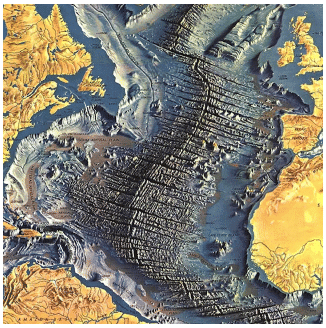
Bottom Reliefs of the Atlantic Ocean
- The Atlantic Ocean located between North and South Americas in the west and Europe and Africa in the east covers an area of 82,000,000 km2 which is 1/6th of the geographical area of the globe and half of the area of the Pacific Ocean.
- The ‘S’ shape of the ocean indicates the fact that landmasses (continents) on its either side were once a contiguous part.
- The Atlantic Ocean was formed due to drifting of North and South Americas to the west due to plate tectonics.
- The ocean widens to the south of equator and attains the maximum width of 5,920 km at 35°S latitude. It narrows down towards the equator.
- It is only 2560 km wide between Liberian coast and Cape Sao Roque. The width further increases northward and it becomes 4800 km at 40°N latitude.
- It narrows down in the extreme north where it maintains its contact with the Arctic Ocean through Norwegian Sea, Denmark Strait and Davis Bay.
- The average depth of the ocean is less than the Pacific Ocean because of extensive continental shelves and marginal and enclosed seas. About 24 per cent of the Atlantic Ocean is less than 915m deep.
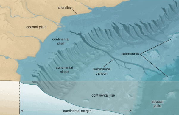
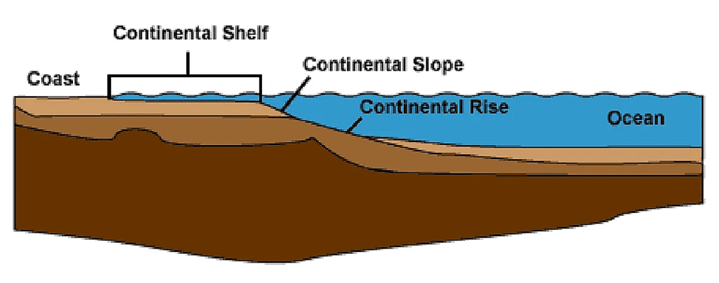
Continental Shelf
- Continental shelves have developed along both the coasts of the Atlantic Ocean and the width ranges from 2-4 km to more than 80 km.
- In fact, the width of continental shelves has been largely controlled by the reliefs of the coastal lands.
- These become significantly narrow where mountains and hills border the coasts e.g., the African shelves between Bay of Biscay and Cape of Good Hope and Brazilian shelves between 5°S and 10°S latitudes.
- The shelves become 200 to 400 km wide along the north-eastern coast of North America and the north-western coast of Europe. Extensive shelves are found around Newfoundland (Grand Bank) and British Islands (Doggar Bank).
- Similarly, the continental shelves around Greenland and Iceland are quite wide.
Mid-Atlantic Ridge
- The mid-Atlantic ridge representing the zone of divergent or constructive plate margins (American plates moving westward and Eurassian and African plates moving to the east) is the most striking relief feature which having S shape extends for 14,450 km from Iceland in the north and to Bouvet Island in the south.
- Though swinging west and east it maintains its central position and nowhere goes down more than 4000m below sea level.
- The ridge is known as Dolphin Rise to the north and Challenger Rise to the south of equator. It is known as Wyville Thompson Ridge between Iceland and Scotland.
- The ridge becomes quite extensive to the south of Greenland and Iceland and is called Telegraphic Plateau because first cabbies were laid down in this area.
Ocean Basins
The mid-Atlantic Ridge divides the Atlantic Ocean into two major basins viz. East and West Atlantic Basins.
 Ocean Basins
- Labrador basin extends between the continental shelf of Greenland in the north and Newfoundland Rise in the south covering latitudinal extent of 40° N to 50°N where the depth of the basin ranges from 4,000 to 4,500m.
- North American basin is the most extensive basin of the Atlantic Ocean and extends between 12°N and 40° latitudes. The east-west section lies between the continental shelves off the east coast of N. America and 50°W meridian. The depth of the basin is more than 5000m but a few deeps measure more than 6000m depth.
- Brazilian basin is confined between the equator and 30°S latitude and east coast of Brazil in the west and Para Rise in the east. The depth is more than 4,000m.
- Spanish basin is located between the mid-Atlantic Ridge and the Iberian Peninsula. It is bordered by Azores Rise in the south and extends up to 50°N latitude. The average depth is 5,000m.
- North and South Canary Basin is comprised of two almost circular basins and is 5,000m deep.
- Cape Verde basin is located between the mid-Atlantic Ridge and the west African coast and extends from 10° N to 23.° N. Average depth is 5000 m but at a few places it becomes 5000 m or more.
- Guinea basin extends from north-east to southwest in an elongated shape between Guinea Ridge and Sierra Leone Rise and measures 4,000 to 5,000 m in depth.
- Angola basin is located between the equator and 30°S latitude. It stretches from the African coast in the northeast to the knot of the mid-Atlantic Ridge and Walvis Ridge in the southwest. The basin is most extensive near the African coast and narrows down towards the south-west. The average depth is 5,000m.
Ocean Deeps
- The number of deeps in the Atlantic Ocean is far less than in the Pacific Ocean because of the absence of the effects of Tertiary orogenic movements along the Atlantic coasts. Murray has identified 29 deeps upto the depth of 3,000 fathoms (5,486.4m) in the Atlantic Ocean.
- Nares Deep (6,000m), Pureto Rico Deep (8,385m), Hatteras Deep (5,445m), Columbia Deep (5,125m, south of Haiti), Valdivia Deep (3,134 fathoms), Tizard or Romanche Deep (9,370m), Buchanan Deep (3,063 fathoms), Moseley Deep (3,309 fathoms), Vema Deep (4,900m) etc. are a few important ocean deeps of the Atlantic Ocean.
- The Mediterranean Sea, Caribbean Sea and Gulf of Mexico are significant marginal seas in the Atlantic Ocean. The Mediterranean Sea is divided into two major basins (East and West Basins) by 4,000m deep mid-sea ridge which runs from the southern Italian coast to the north African coast.
- The Gulf of Mexico and Caribbean Sea are separated by a 1,600 m deep ridge running between Yucatan Peninsula and Cuba Island. The prominent basins are Mexico basin and Caribbean basin. The latter is further divided into four sub-basins e.g. Yucatan basin, Cayman trough, Columbia basin and Venezuela basin.
Bottom Reliefs of the Pacific Ocean
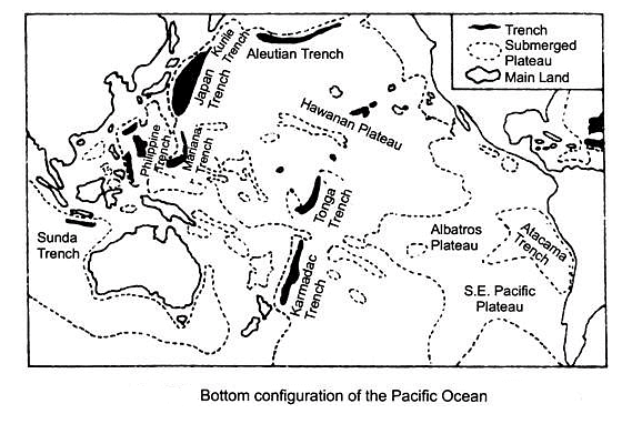
- The Pacific Ocean, the largest ocean of the world having one-third area of the globe, extends from east to west for 16,000 km from the east coast of Asia in the west to the west coasts of Americas in the east and for 14,880 km from north to south between Bering Strait in the north to Cape Adre (Antarctica) in the south.
Johnson has divided the Pacific Ocean into four sub-regions:
- The Northern Pacific represents the deepest part of the whole Pacific where average depth ranges between 5000m and 6000m. This region makes contact with the Arctic Sea through Bering Strait.
- The Central Pacific is characterized by largest number of islands most of which are of volcanic and coral origin. H.H. Hess has identified 160 flat-topped sea mounts in this region. There are a few sub-parallel island chains which have been named by E. Suess as Oceanides.
- The South-West Pacific carries a large number of islands, marginal seas, extensive continental shelves and oceanic trenches.
- The South-East Pacific has the most striking relief of the Pacific Ocean as the East Pacific Rise or Ridge but there is absence of marginal seas.
Continental Shelf
- There is significant difference in the extent and characteristics of continental shelves on the eastern and western coasts of the Pacific. The shelves are quite broad and extensive along the eastern coasts of Australia and Asia where the width varies from 160 km to 1600 km and the depth ranges between 1000 m and 2000m.
- These continental shelves also carry numerous marginal seas like Bering Sea, Okhotsk Sea, Japan Sea, Yellow Sea, China Sea, Java Sea, Coral Sea, Tasmania Sea, Arafura Sea etc. The continental shelve are less extensive along the western coasts of the Americas because of the nearness of cordillerean chains of folded mountains to the coastal lands.
East Pacific Rise
- The Pacific Ocean does not have central or mid- oceanic ridge like the Atlantic and the Indian Oceans, albeit there are a few scattered ridges having local importance.
- The East Pacific Rise or Ridge known as Albatross Plateau is 1600 km wide and it extends from north of New Zealand to the Californian coast. It sends off two branches between 23°S-35°S.
A minor ridge known as Galapagos Ridge runs parallel to the East Pacific Ridge in the east between the Eastern Island Fracture Zone and Galapagos islands from where in moves in two branches viz.:
- Carnegie Ridge, and
- Cocos Ridge in north-east direction.
Ocean Basins
- Philippine basin is located to the east of Philippines and extends from south of Japan to 5°N latitude. Kyushu – Paian Ridge runs through the middle of the basins. Average depth ranges from 5000m to 6000m.
- Fiji basin is located to the south of Fiji Island between 10°S and 32°S latitudes and the average depth is 4000m. The basin to the north of 20°S is known as North Fiji Basin whereas the South Fiji Basin between 20°S and 32°S is bordered by Norkolk Island Ridge in the west and Karmadec – Tonga Trenches in the east.
- East Australian basin is situated between the east coast of Australia and New Zealand Ridge with average depth of more than 5000m.
- South Australian Basin also known as Jeffreys Basin is located to the south-east of Australia having average depth of 5000m.
- Peru basin is located to the west of Peru coast between 5°S and 24°S latitudes and extends upto 110°W longitude. The average depth of the basin is 4000m.
- South-Western Pacific basin is an elongated basin stretching between 20°S and 50°S latitudes and 180-129°W longitudes. Karmadec Trench with the depth of 10,047 m is located to the west of this basin.
- Pacific-Antarctic Basin is located to the southwest of Chilean coast between 40°S and 60°S latitudes and extends up to 130°W longitude.
Bottom Reliefs of the Indian Ocean
- The Indian Ocean is smaller than the Pacific and Atlantic Ocean in areal extent and is bounded by, on all of its sides, Asia in the north, Africa in the west, Asia in the east, Australia in the south-east and Antarctica in the south.
- The ocean has contact with the Pacific and the Atlantic oceans in the south near Antarctica. The average depth of the ocean is 4000m.
- Major parts of the coastal lands of the Indian Ocean formed by the block mountains of Gondwanaland are compact and solid.
- The coasts of the East Indes are bordered by fold mountain chains. The marginal seas are less in number than the Pacific and the Atlantic oceans. Significant marginal seas are Mozambique Channel, Red Sea, Persian Gulf, Andman Sea, Arabian Sea, Bay of Bengal etc. Malgasy (Madagascar) and Sri Lanka are the big islands whereas Suqutra, Zanzibar, Comoro, Reunion, Secychelles, Prince Edwards, Crozet, Kerguelen, St. Paul, Rodriges, Maldive, Laccadive, Andman-Nicobar, Christmas etc. belong to the category of small and tiny islands. Indian subcontinent in the north divides the Indian Ocean into Arabian Sea and Bay of Bengal.
The ocean widens in the south Johnson has divided the Indian Ocean in 3 zones on the basis of regional characteristics:
- The Western Zone between African coast and the mid-Indian Oceanic Ridge has large number of islands and the average depth is 3650 m (2000 fathoms).
- The Eastern Zone is deepest of all the zones with average depth of 550 m (3000 fathoms). The continental shelves are narrow but have steep slopes.
- The Central Zone represents the mid-oceanic ridge where many tiny islands are located.
[Inrext Question]
Continental Shelf
- There is wide range of variation in the continental shelves of the Indian Ocean. Quite extensive shelves are found along the margins of Arabian Sea and Bay of Bengal. Similarly, extensive shelves are observed along the eastern coast of Africa and around Madagascar which is itself located on the continental shelves.
- On an average, the continental shelves are very wide (640 km) in the west whereas these are narrow (160 km) along the coast of Java and Sumatra.
- These become further narrow along the northern coast of Antarctica.
Mid-Oceanic Ridge
- The main central ridge starts from the continental shelf of the southern tip of Indian Peninsisula with average width of 320 km. This part of the ridge is known as Laccadive-Chagos Rigde (also known as Maldive Ridge).
- The ridge further extends southward and widens near equator. It is called Chagos- St. Paul Ridge between equator and 30°S latitude where the average width becomes 320 km.
- The ridge further widens to 1,600 km between 30°S and 50°S latitudes and is known as Amsterdam-St Paul Plateau.
- The central ridge bifurcates to the south of 50°S latitude. The western branch known as Kerguelen-Gaussberg ridge extends in NW-SE direction between 48°S and 63°S and the eastern branch is known as Indian-Antarctic Ridge.
Branches of the Central Ridge
- Socotra-Chagos Ridge also known as Carlesbreg Ridge emerges from the central ridge at 5°S latitude and extends in northwesterly direction upto Gardafuli Peninsula of N. E. Africa,
- Seychelles – Mauritius ridge bifurcates from the main ridge around 18°S latitude near Mauritius Island and runs in roughly north-west direction in arcuate shape upto Seychelles and Amirante islands.
- Madagascar Ridge stretches from the southern tip of Madagascar (Malagasy) to 40°S latitude. Its further southward extension is known as Prince Edward – Crozet Ridge between 40°S -48°S latitudes.
- Ninety East Ridge extends from the continental shelf off the Irrawadi river mouth and runs in almost north-south direction parallel to 90°E longitude upto 40°S where it merges with Amsterdam- St Paul Plateau.
- The south-western branch near 23°S latitude is known as S.W. Indian Ridge.
Ocean Basins
- Oman basin faces the Gulf of Oman and is spread over the extensive continental shelf with average depth of 3,658 m.
- Arabian basin is located in almost circular shape between Laccadive-Chagos ridge and Socotra – Chagos Ridge with the depth of 3,600m – 5,486m.
- Somali basin is bordered by Socotra – Chagos ridge in the north-west. Central Ridge in the east, Seychelles – Mauritius Ridge in the south-west and African coast in the west. The average depth is 3,600m.
- Mauritius basin is located between S.W. Indian Ridge and South Madagascar Ridge and extends from 20°S to 40°S latitude. The depth varies between 3,600m and 5,486 m. The deepest part measures 6,391 m depth.
- Mascarene basin of oval shape extends between Madagascar and Seychelles – Mauritius Ridge.
- Agulhas-Natal basin is an elongated basin which is bordered by Madagascar ridge in the north and north-east, Prince Edward Crozet Ridge in the east and the S.E. African coast in the west and north-west, Average depth is 3,600m.
- Atlantic- Indian – Antarctic basin is in fact the eastward continuation of Atlantic – Antarctic Basin. It stretches upto 70°E longitude and is bordered by Prince Edward Crozet Ridge in the north, Antarctica in the south and Kerguelen Gassberg Ridge in the north-east. Average depth is 3,600m.
- Eastern Indian-Antarctic basin is located between Amsterdam – St. Paul Plateau and Indian-Antarctic Ridge in the north and north-east and Antarctica in the south. The depth varies from 3,600m to 4,800m. Kerguelen – Gassberg Ridge separates the basin from the Atlantic – Indian-Antarctic Basin.
- West Australian basin is the most extensive basin and forms rectangular shape surrounded by S.E. Indian Ridge in the south – west, Ninety East Ridge in the west, continental shelves of Java-Sumatra in the northeast and the continental shelf of west Australia, Average depth varies from 3,600m to 6,100m but the central part of the basin is 6,459 m deep.
- Mid-Indian basin is bordered by the central ridge in the west and the south-west, by Ninety East Ridge in the east and by the Bengal plateau in the north. The average depth of outer part ranges from 3,600m to 6,800m while the depth of the central part of the basin ranges between 4,800m and 6,100m.
|
303 videos|636 docs|252 tests
|
FAQs on Bottom Topography of the Atlantic, Indian & Pacific Oceans - Geography Optional for UPSC
| 1. What are the main features of the bottom reliefs of the Atlantic Ocean? |  |
| 2. How does the Mid-Atlantic Ridge contribute to oceanic geology? | |
| 3. What distinguishes the East Pacific Rise from the Mid-Atlantic Ridge? | |
| 4. What are ocean deeps, and why are they important in oceanography? | |
| 5. How do the bottom topographies of the Atlantic, Indian, and Pacific Oceans compare? | |


Bottom Topography of the Atlantic
,Summary
,Indian & Pacific Oceans | Geography Optional for UPSC
,Exam
,Semester Notes
,video lectures
,shortcuts and tricks
,Indian & Pacific Oceans | Geography Optional for UPSC
,past year papers
,mock tests for examination
,practice quizzes
,study material
,Viva Questions
,Bottom Topography of the Atlantic
,MCQs
,Bottom Topography of the Atlantic
,Important questions
,Previous Year Questions with Solutions
,Objective type Questions
,Free
,Sample Paper
,ppt
,Extra Questions
,Indian & Pacific Oceans | Geography Optional for UPSC
;


Bottom Topography of the Atlantic, Indian & Pacific Oceans Free PDF Download
Importance of Bottom Topography of the Atlantic, Indian & Pacific Oceans
Bottom Topography of the Atlantic, Indian & Pacific Oceans Notes
Bottom Topography of the Atlantic, Indian & Pacific Oceans UPSC Questions
Study Bottom Topography of the Atlantic, Indian & Pacific Oceans on the App
|
© EduRev
|
Education Revolution
|


|


