Earthquakes and Tsunamis | Geography Optional for UPSC PDF Download
| Table of contents |

|
| Earthquake |

|
| Classification of Earthquake |

|
| Consequences of Earthquake |

|
| Earthquake Management |

|
| Tsunami |

|
| Frequently Asked Questions (FAQs) of Earthquakes and Tsunamis |

|
Earthquake
- An earthquake refers to the shaking or trembling of the Earth's surface, which occurs due to a sudden release of energy within the Earth's lithosphere. This energy takes the form of seismic waves, which travel through the surface layers of the Earth. Earthquakes can be caused by various factors, such as faulting, folding, plate movements, volcanic eruptions, and human-made factors like dams and reservoirs.
- Among all natural disasters, earthquakes are the most unpredictable and have the potential to cause significant destruction. Earthquakes can range in severity from minor tremors, which are caused by gentle waves of vibration within the Earth's crust and occur frequently, to major earthquakes that result from movement along faults. These major earthquakes can be particularly devastating, especially in densely populated areas.
Earthquake-Related Terminology
- Earthquake intensity: The measure of the severity of shaking produced by an earthquake at a given location.
- Earthquake magnitude: The measure of the energy released by an earthquake.
- Richter Scale: A scale developed by Charles F. Richter in 1935 to quantify the magnitude of an earthquake.
- Mercalli Scale: A seismic scale used to measure the intensity of an earthquake by observing its effects on people and structures.
- Fault: A fracture or zone of fractures in the Earth's crust where rocks on either side have moved relative to each other.
- Focus (or hypocenter): The point within the Earth where an earthquake begins.
- Epicenter: The point on the Earth's surface directly above the focus.
- Seismic wave: Waves of energy caused by the sudden breaking of rock within the Earth, which travel through the Earth and are recorded on seismographs.
- Seismograph: An instrument used to detect and record seismic waves.
Focus and Epicenter
The focus, or hypocenter, is the starting point of an earthquake within the Earth. The epicenter is the point on the Earth's surface directly above the focus. The intensity of the earthquake is highest at the epicenter and decreases as one moves away from it.
Richter Scale
The Richter magnitude scale measures the energy released by an earthquake. The scale ranges from 0 to 9, with each whole number increase representing a tenfold increase in shaking amplitude and a 31.6 times increase in energy released.
Mercalli Scale
The Mercalli intensity scale measures the effects of an earthquake on people, structures, and the Earth's surface. The scale ranges from 1 to 12, with higher numbers representing more severe effects.
Seismic Waves
Seismic waves are energy waves that result from the sudden breaking of rock within the Earth. There are two main types of waves: body waves and surface waves.
Body Waves
- Primary waves (P-waves): These are the fastest seismic waves, capable of moving through gases, solid rock, and fluids. P-waves cause rocks to move back and forth, similar to the movement of sound waves through the air.
- Secondary waves (S-waves): These waves are slower than P-waves and can only travel through solid rock. S-waves cause rocks to move up and down or side-to-side and arrive at the surface after P-waves.
Surface Waves
- Love waves (L-waves): Named after British mathematician A.E.H. Love, these waves are the fastest surface waves, moving the ground from side-to-side.
- Rayleigh waves: These waves cause the ground to move in an elliptical motion, with both vertical and horizontal components.

Rayleigh Waves
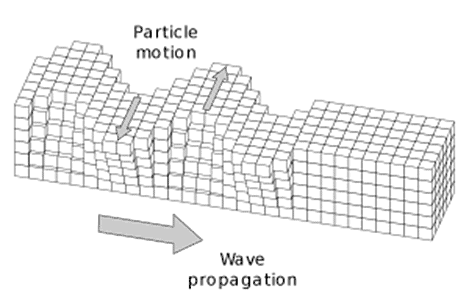
- The other kind of surface wave is the Rayleigh wave, named after Lord Rayleigh.
- A Rayleigh wave rolls along the ground just like a wave rolls across a lake or an ocean.
- Because it rolls, it moves the ground up and down, and side-to-side in the same direction that the wave is moving.
- Most of the shaking felt from an earthquake is due to the Rayleigh wave, which can be much larger than the other waves.
Classification of Earthquake
1. Classification of Earthquakes Based on Causative Factors:Natural Earthquakes:
- Volcanic: Caused by volcanic activity
- Tectonic: Caused by movement of tectonic plates
- Isostatic: Caused by adjustments of the Earth's crust due to changes in weight distribution
- Plutonic: Caused by the movement of magma beneath the Earth's surface
- Artificial Earthquakes: Human-induced, such as those caused by mining or reservoir construction
2. Classification of Earthquakes Based on Depth of Focus:
- Shallow focus (0-50 km): Earthquakes with a focal depth of less than 50 km
- Intermediate focus (50-250 km): Earthquakes with a focal depth between 50 and 250 km
- Deep focus (250-700 km): Earthquakes with a focal depth greater than 250 km
3. Classification of Earthquakes Based on Human Casualties:
- Moderate: Earthquakes resulting in fewer than 50,000 deaths
- Highly hazardous: Earthquakes resulting in 51,000 to 100,000 deaths
- Most hazardous: Earthquakes resulting in more than 100,000 deaths
Global Distribution of Earthquakes: Earthquake distribution around the world is closely related to the distribution of volcanoes. The areas with the highest seismic activity are found in the Circum-Pacific regions, with the most frequent earthquakes occurring along the "Pacific Ring of Fire." Approximately 70% of all earthquakes take place in this belt.
Another 20% of earthquakes occur in the Mediterranean-Himalayan belt, which includes Asia Minor, the Himalayas, and parts of northwestern China.
The remaining 10% of earthquakes occur within the interiors of tectonic plates and at spreading ridge centers.
Earthquake Causes
Earthquakes are primarily caused by an imbalance or dis-equilibrium in the Earth's crust. This imbalance can be attributed to various natural and man-made factors.
1. Natural Causes:
- Volcanic eruptions
- Faulting and folding
- Upwarping and downwarping
- Expansion and contraction of gases within the Earth
- Movement of tectonic plates
- Landslides
2. Anthropogenic (Man-made) Causes:
- Deep underground mining
- Blasting of rocks with dynamite for construction purposes
- Deep underground tunnels
- Nuclear explosions
- Reservoir-Induced Seismicity (e.g., the 1967 Koyna Reservoir earthquake)
- Hydrostatic pressure from man-made water bodies like reservoirs and lakes
Plate tectonics offer the most logical explanation for the occurrence of earthquakes and volcanoes. Earthquakes usually occur along three types of plate boundaries: convergent, divergent, and transform.
- In India, earthquakes are more frequent in areas where the Indian Plate converges with the Eurasian Plate, such as the Himalayan region. Although the peninsular part of India is generally considered a stable block, occasional earthquakes are felt along the margins of minor plates, like the 1967 Koyna earthquake and the 1993 Latur earthquake.
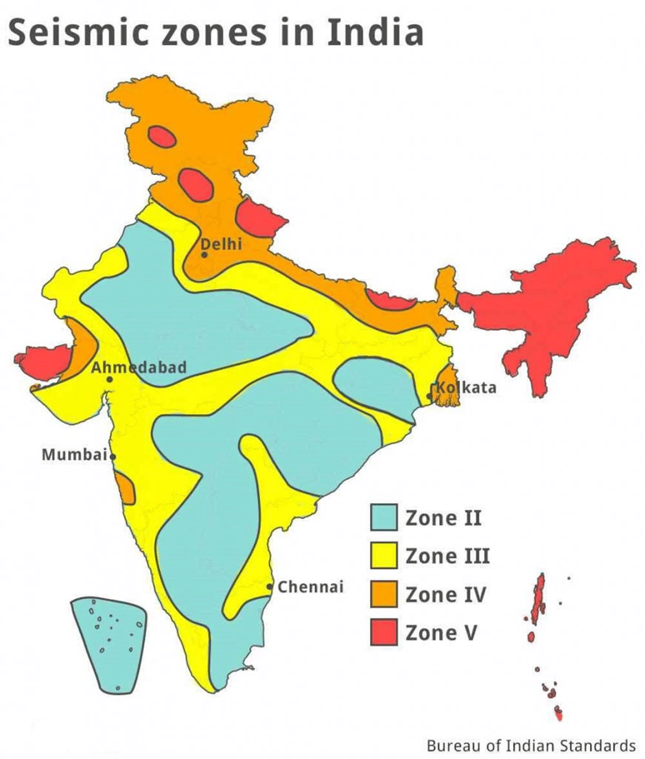
- Indian seismology experts have classified the country into four seismic zones: Zone II, Zone III, Zone IV, and Zone V. The highest and high-risk categories, Zone V and Zone IV, include the entire Himalayan region, the northeastern states, Western and Northern Punjab, Haryana, Uttar Pradesh, Delhi, and parts of Gujarat. The remaining parts of the northern plains and western coastal areas fall under the moderate-risk zone, while a large portion of the peninsular region is in the low-risk zone.

Consequences of Earthquake
Impact of EarthquakesEarthquakes can cause significant damage to human life and property due to the deformation of the ground surface resulting from the vertical and horizontal movement of the Earth's crust. For instance, the 2015 Nepal earthquake, which had a magnitude of 7.8 and a depth of 8.2 km, led to massive casualties and destruction due to poorly designed buildings and unscientifically constructed structures in urban areas. The city of Kathmandu experienced significant damage, with a death toll of around 8,000 people and an economic loss of 10 billion USD.
- Landslides and Avalanches: In mountainous regions, earthquake tremors can lead to slope instability and failure, resulting in landslides as debris falls down the slope. Additionally, large masses of ice may become dislodged from snow-covered peaks due to earthquakes, causing avalanches. For example, the 2015 Nepal earthquake triggered several avalanches around Mount Everest, while the 2011 Sikkim earthquake led to landslides and significant damage to life and property, particularly the Singik and Upper Teesta hydropower projects.
- Floods: Earthquakes can cause severe disruption to dams and reservoirs, potentially leading to flash floods. Landslides and avalanches can also block river courses, contributing to flooding. The 1950 Assam earthquake, for instance, created a barrier in the Dihang River due to the accumulation of massive debris, causing flash floods in the upstream section.
- Tsunamis: Tsunamis are waves generated by the disruption of ocean basins and the displacement of large volumes of water. Seismic waves from an earthquake can displace the seafloor and create high sea waves, such as tsunamis. The 2004 Indian Ocean tsunami, which occurred on December 26th, was caused by an earthquake off the coast of Sumatra. The event was triggered by the subduction of the Indian plate under the Burmese plate, killing around 240,000 people in countries surrounding the Indian Ocean.
- Fukushima Nuclear Accident: The 2011 Tohoku earthquake in Japan, which had a magnitude of 9, resulted in tsunami waves reaching heights of 10 meters due to an undersea earthquake. These waves destroyed the emergency generators that cooled the reactors at the Fukushima Daiichi nuclear plant, leading to nuclear meltdown and radioactive fallout. The incident became a global concern as the radiation spread worldwide.
Earthquake Management
Earthquake management involves organizing and managing resources and responsibilities to address all humanitarian aspects of emergencies, with the goal of minimizing the negative effects of such hazards. Earthquake management encompasses everything from pre-earthquake risk reduction measures to post-earthquake recovery efforts.
- Risk Recognition: The first step in earthquake management is identifying areas that are more susceptible to earthquakes. This helps in prioritizing resources and planning for potential disasters.
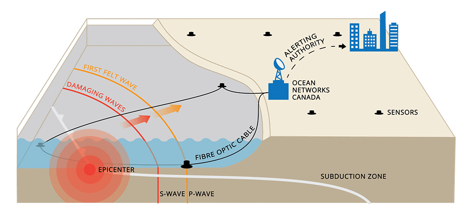
- Earthquake Monitoring and Early Warning Systems: Accurately predicting the occurrence of an earthquake in a specific region remains a challenge for seismologists. However, the focus has shifted towards developing earthquake forecasting systems to mitigate the impact of potential disasters. For example, Japan has implemented an earthquake early warning system that utilizes electronic signals, which travel faster than earthquake waves, to provide advance notice of an impending quake.
- Structural Solutions: Historical data reveals that over 95% of lives lost in earthquakes are due to the collapse of non-earthquake resistant buildings. Constructing earthquake-resistant buildings is more expensive compared to regular structures, which poses a challenge for countries with limited financial resources, such as India. A possible solution to this issue is seismic strengthening, which involves prioritizing structures for retrofitting and ensuring they meet safety standards. To implement this approach effectively, it is crucial to develop an earthquake hazard map that categorizes different zones based on their vulnerability to earthquakes.

Tsunami
A tsunami is a series of large ocean waves caused by seismic activity, such as earthquakes, that displace large volumes of water. The term "tsunami" comes from the Japanese words "tsu," meaning harbor, and "nami," meaning wave. These waves can cause massive destruction in coastal areas where underwater earthquakes occur.- For a tsunami to occur, two conditions must be met: there must be an earthquake that transfers energy, and there must be a vertical displacement of water. This typically happens near oceanic trenches, where tectonic plates are being subducted. Tsunamis are not formed in areas where there is no sudden vertical movement, such as the Mid-Atlantic ridge. Seamounts breaking can also trigger tsunamis by causing a vertical displacement of water.
- When a tsunami is generated, its height-to-length ratio is very small, which allows it to pass unnoticed beneath ships at sea. As the wave approaches the shore, its height increases rapidly due to the rebound from the shallow surface. The wave's period remains constant, but its velocity decreases and its height increases. In confined coastal waters, tsunamis can reach heights of over 30 meters.
- Tsunamis travel at speeds of 100-150 km/h in deep water, which can increase to 650-900 km/h. As they enter shallower waters near the coast, their velocity decreases and their height increases due to the "shoaling" effect. This causes a tsunami that was barely noticeable in deep water to grow several feet or more in height as it approaches the shore.
- The Pacific Ocean has the highest frequency of tsunamis, and since 1948, an International Tsunami Warning Network has been in place to alert coastal residents of potential dangers.
- Tsunamis can be caused by various factors, including earthquakes, landslides, undersea volcanoes, meteor and asteroid impacts, and human activities such as nuclear explosions.
- Since scientists cannot predict when earthquakes will occur, they cannot accurately predict when a tsunami will be generated. However, historical records and numerical models can help determine where tsunamis are most likely to occur. The most effective way to mitigate the impact of a tsunami is through an early warning system.
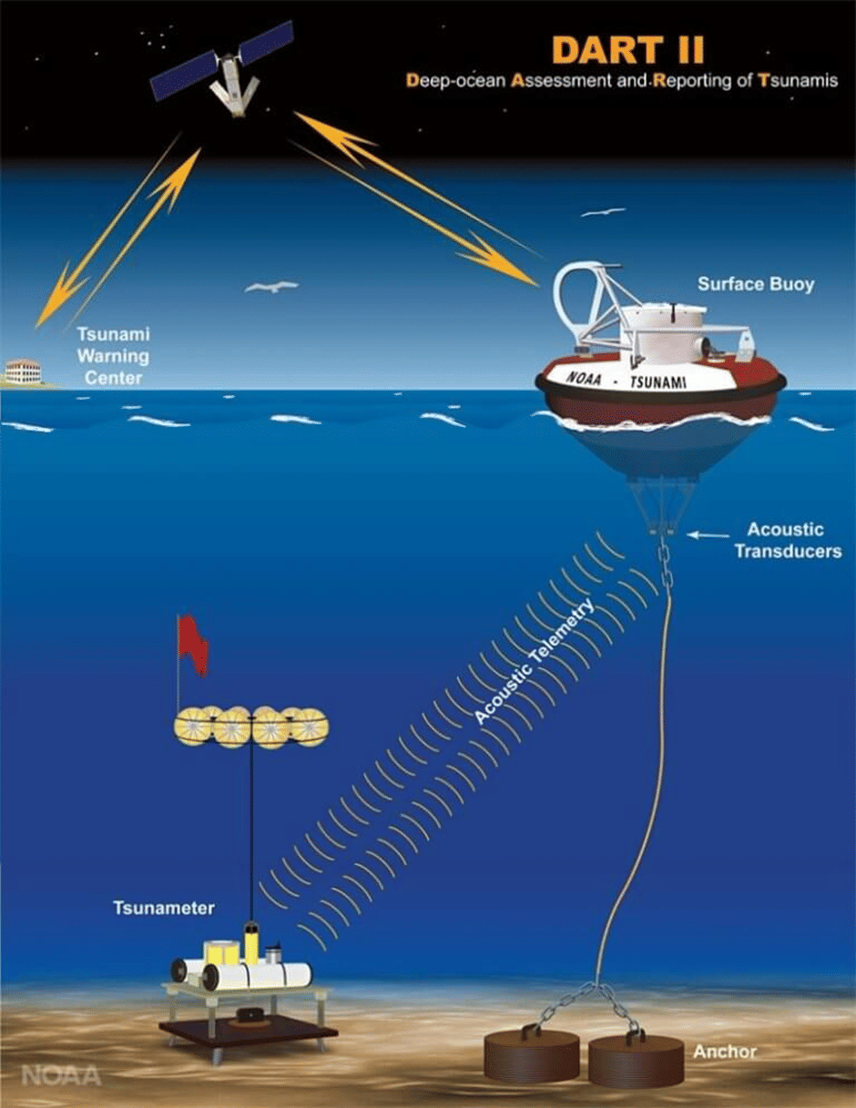
- A tsunami early warning system (TWS) detects tsunamis in advance and issues warnings to protect people's lives. It consists of two equally important components: a network of sensors that detect tsunamis and a communication infrastructure that issues timely alerts for evacuation of coastal areas. While it is not possible to predict the exact timing of a tsunami, early warning systems can help save lives and minimize damage by providing advanced notice to those in affected areas.

- Numerous early warning systems are in place around the world to alert citizens of potential natural disasters. These systems use various methods to communicate warnings, such as text messages, radio and television broadcasts, sirens, mosque loudspeakers, and police vehicles with loudspeakers.
- India joined the International Tsunami Warning System following the devastating tsunami in December 2004. Established in 2007, the Indian Tsunami Early Warning Centre (ITEWC) is part of the Indian National Centre for Ocean Information Sciences in Hyderabad, an autonomous organization under the Ministry of Earth Sciences. The ITEWC is equipped with the Deep Ocean Assessment and Reporting of Tsunamis (DART) system and is considered one of the best in the world.
- The ITEWC monitors seismic activity through a network of seventeen broadband seismic stations designed to detect tsunamigenic earthquakes and provide timely warnings to vulnerable populations. Additionally, the center collects data from global networks to identify earthquakes with a magnitude of at least 6.5. Since its inception in 2007, the ITEWC has monitored 339 such earthquakes.
- Furthermore, the ITEWC serves as one of the Regional Tsunami Advisory Service Providers (RTSP) for the Indian Ocean region, alongside Australia and Indonesia.
Conclusion
Earthquakes and tsunamis are natural disasters that occur due to the sudden release of energy within the Earth's lithosphere, leading to destructive seismic waves. Various natural and human-induced factors contribute to the occurrence of earthquakes, which can be categorized based on their causes, depth, and the extent of human casualties. On the other hand, tsunamis result from events such as earthquakes, landslides, and undersea volcanic eruptions, among others. These disasters can cause significant damage to human life, property, and the environment. To minimize the impacts of earthquakes and tsunamis, it is crucial to establish early warning systems. Organizations like the International Tsunami Warning System and the Indian Tsunami Early Warning Centre play a vital role in detecting tsunamis and providing timely alerts. These systems allow for the evacuation of coastal areas, reducing the potential loss of life and property during such disasters.Frequently Asked Questions (FAQs) of Earthquakes and Tsunamis
What is an earthquake, and what causes it?
An earthquake is the shaking of the Earth's surface, resulting from the sudden release of energy in the Earth's lithosphere that creates seismic waves. It can be caused by factors such as faulting, folding, plate movement, volcanic eruptions, and anthropogenic factors like dams and reservoirs.
What is the difference between the Richter Scale and the Mercalli Scale?
The Richter Scale measures the magnitude of energy released by an earthquake, with values ranging from 0 to 9. The Mercalli Scale, on the other hand, measures the intensity of an earthquake and its effects, with values ranging from 1 to 12.
What are the different types of seismic waves?
Seismic waves can be classified into two main types: body waves and surface waves. Body waves include Primary waves (P-waves) and Secondary waves (S-waves). Surface waves include Love Waves (L-waves) and Rayleigh waves.
How can tsunami waves be generated?
Tsunamis can be generated by various causes such as earthquakes, landslides, undersea volcanoes, and meteor or asteroid impacts. The displacement of a large volume of water in the ocean due to these events can lead to the formation of tsunami waves.
What is a tsunami early warning system, and how does it work?
A tsunami early warning system (TWS) is a network of sensors and communication infrastructure designed to detect tsunamis and issue timely alarms for the evacuation of coastal areas. It consists of two equally important components: a network of sensors to detect tsunamis and a communications infrastructure to issue timely alarms to permit evacuation of the coastal areas.
|
303 videos|635 docs|252 tests
|
FAQs on Earthquakes and Tsunamis - Geography Optional for UPSC
| 1. What is the classification of earthquakes? |  |
| 2. What are the consequences of an earthquake? |  |
| 3. How is earthquake management carried out? |  |
| 4. What is a tsunami? |  |
| 5. How do earthquakes and tsunamis affect the environment? |  |


