Ecological Issues: Environmental Hazards: Landslides, Earthquakes, Tsunamis, Floods & Droughts -2 | Geography Optional for UPSC (Notes) PDF Download
Tsunami
The seismic waves traveling through the ocean and seawater results in high sea waves which are known as tsunami.
- ‘Tsunami’ is a Japanese term represented by two characters: “tsu” and “nami”. The character “tsu” means harbor, while the character “nami” means wave. which has been universally adopted to describe a large seismically generated sea wave.
- These waves are responsible for causing considerable destruction in certain coastal areas where submarine earthquakes occur.
- It is a series of waves of extremely long wavelengths and long periods generated in a body of water by an impulsive disturbance that displaces water.
For a Tsunami to occur, two conditions are required:
- There should be an earthquake from which energy can be transferred.
- There should be a vertical displacement of the water. i.e. during an earthquake, the crust should move vertically. That’s why Tsunamis are originated near oceanic trenches where plates are being subducted. In the Atlantic Ocean, a number of earthquakes occur on the Mid–Oceanic ridge but since there is no sudden vertical movement, Tsunamis are not formed. Tsunamis can also be triggered if the seamounts break. This can cause a vertical displacement of water.
Process of Generation of Tsunami:
- When a tsunami is generated, its steepness i.e. height to length ratio is very less.
- This enables it to pass unnoticed beneath the ships in the sea. As the wave approaches the shore, the height of the wave rapidly increases because of the rebound from the shallow surface.
- The period of the wave remains constant, velocity drops, and the height increases. In confined coastal waters relatively close to their point of origin, tsunamis can reach a height of more than 30m. Tsunamis travel at the speed of 100 -150 km/h which may pick up 650-900 km/h.
- When the tsunami enters the shoaling water of coastlines in its path, the velocity of its waves diminishes, and the wave height increases.
- As a tsunami leaves the deep water of the open sea and propagates into the more shallow waters near the coast, it undergoes a transformation.
- Since the speed of the tsunami is related to the water depth, as the depth of the water decreases, the speed of the tsunami diminishes.
- The change in the total energy of the tsunami remains constant. Therefore, the speed of the tsunami decreases as it enters shallower water, and the height of the wave grows.
- Because of this “shoaling” effect, a tsunami that was imperceptible in deep water may grow to be several feet or more in height.
- It may travel a considerable distance. The frequency of tsunami is highest in the Pacific Ocean.
- Since 1948, an International Tsunami Warning Network has been in operation around the Pacific Ocean to alert coastal residents to possible danger.
Causes of Tsunami
- Earthquake
- Landslides
- Undersea Volcanoes
- Meteors, Asteroids
- Anthropogenic Factors Like Nuclear Explosions
Tsunami Early Warning System
- Since science cannot predict when earthquakes will occur, they cannot determine exactly when a tsunami will be generated. But, with the aid of historical records of tsunamis and numerical models, science can get an idea as to where they are most likely to be generated.
- Hence, the only way to effectively mitigate the impact of a tsunami is through an early warning system.
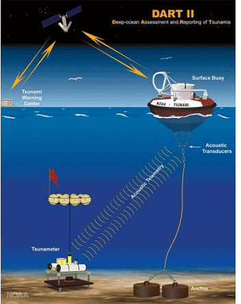
- Tsunamis are detected in advance using a tsunami warning system (TWS) and early warnings are issued to safeguard the life of people. It is made up of two equally important components: a network of sensors to detect tsunamis and a communications infrastructure to issue timely alarms to permit evacuation of the coastal areas.

- Tsunamis are detected in advance using a tsunami warning system (TWS) and early warnings are issued to safeguard the life of people. It is made up of two equally important components: a network of sensors to detect tsunamis and a communications infrastructure to issue timely alarms to permit evacuation of the coastal areas.
- There are many regional and international early warning systems installed all across the globe.
- National governments warn citizens through a variety of means, including SMS messages, radio and television broadcasts, and sirens from dedicated platforms, mosque loudspeakers, and police vehicles with loudspeakers.
- India had volunteered to join the International Tsunami Warning System after the December 2004 tsunami disaster.
- The Indian Tsunami Early Warning Centre (ITEWC) embedded with specific systems called Deep Ocean Assessment and Reporting of Tsunamis (DART), established in 2007 at the Indian National Centre for Ocean Information Sciences, (INCOIS – ESSO) Hyderabad, an autonomous body under the Ministry of Earth Sciences, is up and running to provide tsunami advisories for the events occurring in the global oceans.
- It has been recognized as one of the best systems in the world. The ITEWC includes a real-time seismic monitoring network of seventeen broadband seismic stations to detect tsunamigenic earthquakes and to provide timely warnings to the vulnerable community. It also receives earthquake data from all other global networks to detect earthquakes (of M6.5).
- Since its inception in October 2007, so far ITEWC has monitored 339 earthquakes of M 6.5. ITEWC also acts as one of the Regional Tsunami Advisory Service Provider (RTSP) along with Australia & Indonesia for the Indian Ocean region.
Floods
- A high water level that overflows the natural banks along any portion of a stream is called a flood. Thus, Floods are commonly associated with a stream or river.
- A stream floods when its discharge is greater than the capacity of its river channel. Excess water flows over the river banks and submerges the adjacent land which is usually dry. When it happens, the channel and the flood plain together allow passage of water.

- Floods and Droughts on one hand are cumulative hazards. On the other hand, due to the peculiar nature of the Indian monsoon floods and droughts may affect different pockets of the country at the same time of a year. Thus, floods can be seasonal, and sometimes flash floods also occur.
Causes of Floods
Unlike other natural disasters, the causes of floods are well established. They are relatively slow in occurrences and often occur in well-identified regions and within expected time in a year. There are many causes of floods. Some of the Important causes of floods are:
Natural Causes
- Heavy rainfall and cloud bursts – Heavy concentrated rainfall reduces the capacity of rivers to accept any more surface run–offs due to rainfall and as result water spills over to adjoining areas. Clod bursts are basically thunderstorms which yield very heavy rains (>50 – 100 cm within few hours). All of these can cause extensive damage within short span of time.
- Heavy melting of ice and snow,
- Changes in river systems and large catchment areas,
- Sediment deposition/Silting of river beds,
- The collapse of dams,
- Transgression of sea at the occasion of tropical cyclone, and
- Tsunami in coastal areas and landslides in course of rivers
Man-made/Anthropogenic causes
Unlike other natural disasters, human beings play an important role in the genesis as well as spread of floods.
- Deforestation – It leads to soil erosion and Landslides. It is responsible for the loss of vegetation and soils which holds down the soil that acts as a sponge and absorbs most of the water when it rains. It also leads to silting of river beds.
- Unscientific use of land utilization and bad farming practices – Some farmers have caused soil and water to flush into the rivers by leaving fields bare. Even choosing the wrong direction to plough in can cause floods.
- Increased Urbanisation – It has reduced the ability of the land to absorb rainfall through the introduction of hard impermeable surfaces. This results in an increase in the volume and rate of surface run-off as less water infiltrates into the ground.
Consequences of Floods
Though floods are temporary inundation, they cause extensive damage as the frequency, intensity, and magnitude of floods are increasing day by day. Floods cause more damage than any other single disaster now a day.
- Floods are taking thousands of lives and loss of property every year.
- The crops get adversely affected by the temporary loss of the agricultural season and fertile soil cover.
- It leads to changes in habitats, destruction of habitats, and loss of animals due to drowning.
- Disruption of the lines of rail, road communication, and essential services creating great problems for the movements of people and goods.
- Spread of water-borne and infectious diseases like cholera, gastro-enteritis, etc. immediately after floods.
- Positive consequences – Floods also make a few positive contributions. Every year floods to deposit fertile silt over agricultural fields which are good for the crops. It also recharges the groundwater table.
Flood distribution in India
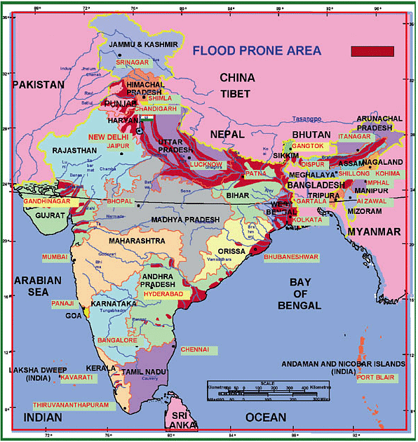
- Floods have been a recurrent phenomenon in India and cause huge losses to lives, properties, livelihood systems, infrastructure, and public utilities. India’s high-risk vulnerability is highlighted by the fact that 40 million hectares out of the geographical area of 3290 lakh hectares are prone to floods, which is 12%.
- State-wise study shows that about 27% of the flood damage in the country is in Bihar, 33% in Uttar Pradesh and Uttarakhand, and 15% by Punjab and Haryana.
- The major flood areas in India are in the Ganges – Brahmaputra – Meghna Basin which accounts for nearly 60% of the total river flow of the country.
- Distribution of flood plains –
- Brahmaputra River Region
- Ganga River Region
- North – West River Region
- Central and Deccan India
- The middle and lower courses of North Indian rivers such as Ganga, Brahmaputra, Kosi, Damodar, Mahanadi, etc. Are prone to floods due to very low gradient. The flat plains do not have enough gradients for the outlet of drainage.
- Peninsular rivers are mature and have hard rock beds, so they have shallow basins. This makes them prone to flooding.
- Parts of the Eastern coasts of India are particularly prone to cyclones during October – November. These cyclones are accompanied by strong winds, storm surges, tidal waves, and torrential rains.
 Flood prone areas
Flood Control Management
The central and State Government have taken the following steps to reduce the menace of floods:-
Flood Forecasting-
- It involves giving prior information regarding the occurrence of floods. It is of immense help in taking timely action to reduce the loss of human lives, livestock, and movable properties. The central water commission started flood forecasting in November 1985, when the first flood forecasting station was established near the old railway bridge of Delhi.
- At present, there are 175 flood forecasting stations on various rivers in the country. The flood forecasting network covers the flood-prone states and UTs where the station issues daily flood warnings throughout the flood season from May to October.
Reduction in Run-off-
- It is one of the very effective methods of flood control. Runoff can be reduced by inducing and increasing infiltration of the surface water into the ground in the catchment areas. This can be done by large scale afforestation, especially in the upper catchment areas.
Construction of Dams-
- Dams and multi-purpose projects are being constructed across the rivers to store the surplus water in the reservoirs. A number of such reservoirs were constructed during the 1st Five-year plan. In the subsequent plans also, many dams have been constructed to reduce the run-off and to store and release water under controlled conditions.
Channel Improvements and Construction of Embankments-
- The channels of the rivers more prone to flood are improved by deepening and widening. The water of those rivers is also diverted into canals.
- The central and state governments have constructed a number of embankments along the rivers to reduce the menace of floods. Such embankments have been constructed along the Brahmaputra, Krishna, Godavari, Gandak, Kosi, and Narmada, Tapi, son, satluj, and their tributaries.
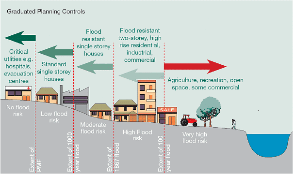
Flood Plain Zoning –
- It is also an important step to control floods which are based on information regarding flood plains, particularly the identification of floodways in relation to land use.
NDMA Guidelines for Flood Management
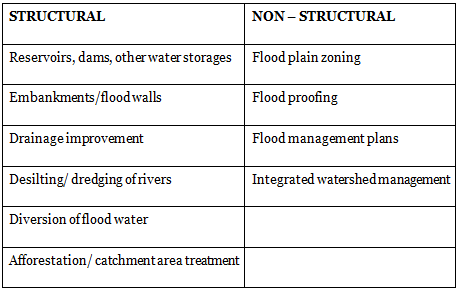
Government Programmes for Flood management
- In addition to the steps given above, legislative measures are taken to restrict the construction of industrial and residential units in flood-prone areas. The construction of buildings, factories, houses in the zones adjacent to river channels should be prohibited. The areas occasionally flooded should be under green belts and social forestry should be encouraged in the flood plain.
- National Flood Control Management Programme, 1954
- At the national level, the first policy statement on flood control in India was established on 3 September 1954. This policy statement envisaged 3 types of flood control measures, namely, Intermediate, short and long term.
- National Hydrology Project, 2016
- It is a central sector scheme with 50% of the outlay amount received from the World Bank loan. This project gathers hydro-meteorological data which will be stored and analyzed on a real-time basis and can be seamlessly accessed by any user at the State/District/Village level.

- It is a central sector scheme with 50% of the outlay amount received from the World Bank loan. This project gathers hydro-meteorological data which will be stored and analyzed on a real-time basis and can be seamlessly accessed by any user at the State/District/Village level.
Mitigation (Post – Flood Management)
- Rescue Operations
- Speedy restoration of the transport system
- Supply of safe drinking water
- Repair of power, telephone, and sewerage lines
- Supply of food, shelter, and clothing
- Survey to assess the loss and compensation
- Rehabilitation of properties
- Desilting and dewatering of inundated areas
- Contingency Plan for the agriculture sector
Drought
- Drought is a temporary reduction in water or moisture availability below the normal or expected amount for a specific period.
- The occurrence of substantially lower than average precipitation in a season that normally has ample precipitation in a season for the support of cereal and non-cereal crops is known as Drought.
- The amount, time, and distribution of rainfall matters. In India, the erratic nature of the summer monsoon with long dry spells and high temperature are responsible for the drought conditions. On average, one in every 5 years is a drought year. In Rajasthan, one in every 3 years is a drought year.
- Drought is a relative phenomenon as the inadequacy is with reference to prevailing agro-climatic conditions. Aridity is a permanent condition whereas drought is a temporary situation. Arid and semi-arid regions are more prone to drought.
Types & Causes of Drought
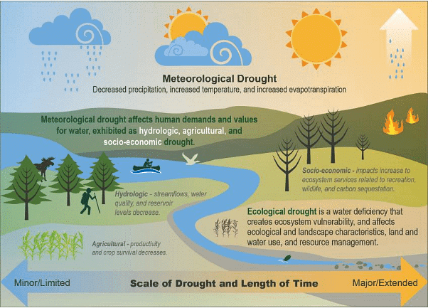
1. Meteorological Drought
- It is a situation where there is a reduction in rainfall for a specific period below a specific amount i.e. the actual rainfall in an area is significantly less than the climatologically mean of that area. According to Indian Meteorological Department (IMD), a drought exists when the average annual rainfall is less than 75% of the normal.
- IMD also mentioned that rather than the total amount of rainfall, its evenness matters more. We can observe that even though India gets an average annual rainfall of 110 cm, the evenness of rainfall, due to the erratic and concentrated nature of rainfall, there are frequent droughts.
- Causes of Meteorological droughts:
- Lean monsoon and below-average rainfall.
- Late-onset or early withdrawal of monsoons.
- Prolonged breaks in Monsoon.

2. Hydrological Drought
- It is associated with the reduction of water levels. There are 2 types of Hydrological Droughts
- Surface water Drought – It is concerned with the drying up of surface water resources such as rivers, streams, lakes, ponds, tanks, reservoirs, etc.
- Groundwater Drought – It is associated with the fall in the groundwater level.
- Causes of Hydrological Drought:
- Large scale deforestation.
- Ecologically hazardous mining.
- Excessive pumping of groundwater.
3. Agricultural Drought
- It occurs when soil moisture goes below the level needed to sustain plant growth. It is also called as Soil Moisture Drought. The erratic rainfall conditions and inadequate soil moisture result in crop failures.
- Causes of Agricultural Droughts:
- Excessive use of High Yielding Seeds (HYV) as these seeds requires more water and proper irrigation.
- Change in cropping pattern. E.g. with the introduction of the green revolution, we increased our production of wheat and rice. Rice is a water-intensive crop and growing them in an area where less water is available made the area prone to agricultural drought.

4. Socio-Economic Drought
- It reflects reduced availability of food and income loss due to crop failure.
5. Ecological Drought
- It occurs when the productivity of the natural ecosystem fails due to a shortage of water and causes environmental damages like the deaths of cattle, wildlife, and trees in the forest.
Droughts in India
Droughts in India have their own peculiarities requiring an appreciation of some basic facts.
These are:-
- India has an average annual rainfall of around 1150 mm. No other country has such a high annual average; however, there is considerable annual variation.
- More than 80% of rainfall is received in less than 100 days during the south-west monsoon and the geographic spread is uneven.
- 21% area receives less than 700 mm rains annually making such areas the hot spot of drought. Inadequacy of rains coupled with adverse land-man ratio compels the farmers to practice rain-fed agriculture in large parts of the country (approx 45%).
- Per capita, water availability in the country is steadily declining. Irrigation, using groundwater aggravates the situation in the long run as groundwater withdrawal exceeds replenishment. In the peninsular region availability of surface water itself becomes scarce in years of rainfall insufficiency.
Most Drought Prone areas in India
- Northwest Region being the arid and semi-arid region of India receives the residual rain from the monsoon as monsoon time over this region is nearly 2 months. Rajasthan and some parts of the west-central areas come in this category.
- Other naturally drought-prone areas are the kutch and the Thar desert region which cannot be fully rectified, what can be done is to reduce the impact by using irrigation methods and crops suitable for the region.
- Peninsular region- The leeward side (rainshadow region) of the western ghat receives little rainfall. Also, this area lacks irrigation. Adding to the deficit rainfall the crops which are chosen on a commercial basis are not suitable for that agro region like cotton and sugarcane in Marathwada which demand high water availability.
- About 30% of the country’s total area is drought-prone affecting 68% of the total sown area. Severity wise, the years of 1965, 1972, 1979, 1987, 2002, 2009, and 2012 were the most severe drought years in post-independence India.
Consequences of Droughts
The direct impact of the drought is generally classified under three categories, viz, Social, economic, and environmental. The relative and absolute magnitudes of each impact will however depend on specific regional characteristics.
- Economic losses:
- It includes a decline in cultivated areas and a fall in agricultural production, which leads to the slowing down of secondary and tertiary activities and a decline in purchasing power.
- Environmental Impact:
- It leads to damages to plant and animal species, wildlife habitat, air and water quality, forest and range fires, degradation of landscape quality, and soil erosion.
- Soil moisture, surface run-off, and groundwater table get adversely affected.
Impact on society:
- Migration of people from drought-hit areas to other areas in search of livelihood and food.
- Farmers tend to commit suicide. Maharashtra, Andhra Pradesh, and Karnataka are the states having maximum farmer suicides.
- Disruption of social institutions and increase in social crimes.
- Scarcity of drinking water, food grains and hence causes famine and starvation.
- Poor health and spread of diseases like diarrhoea, cholera, and other diseases associated with malnutrition, a hunger which sometimes causes death.
Drought Management
Drought management encompasses three-fold structures and each step needs a holistic approach to ensure effective end result. The 3 components are-
- Drought intensity assessment and monitoring
- Drought declaration and prioritization of affected areas for management
- Development and implementation of drought management strategies.
NDMA guidelines for Drought Management-
- NDMA guidelines include developing vulnerability profiles for regions, communities, population groups, and others to compile critical information which when integrated into the planning process can enhance the outcome of the process of identifying and prioritizing specific areas.
- Specific Drought Management cells should be created at the state level under SDMA. These DMCs will be responsible for the preparation of vulnerability maps for their respective states. Arid and semi-arid areas that are most vulnerable should be given priority where drought is a recurring feature occurring with varying magnitudes.
- Specific guidelines for use of Information and Communication Technology (ICT) and role of the National Informatics Center (NIC) for online interaction and availability of real-time drought-related information that will help in the assessment and early warning.
- Assessment of damage expected will include agricultural production, depletion of water resources, livestock population, land degradation, and deforestation as well as human health.
|
191 videos|377 docs|117 tests
|
FAQs on Ecological Issues: Environmental Hazards: Landslides, Earthquakes, Tsunamis, Floods & Droughts -2 - Geography Optional for UPSC (Notes)
| 1. What are the main causes of landslides? |  |
| 2. How can landslides be prevented or mitigated? |  |
| 3. What are the potential environmental impacts of earthquakes? |  |
| 4. How are tsunamis formed and what are their effects on the environment? |  |
| 5. What are the impacts of droughts on the environment and how can they be managed? |  |

