Environment and Ecology: January 2023 UPSC Daily Current Affairs | Environment for UPSC CSE PDF Download
Forest (Conservation) Rules (FCR) 2022
Why In News
- There is an ongoing conflict going on between the government and the National Commission for Scheduled Tribes over the Forest (Conservation) Rules (FCR) 2022.
- The Commission says that the new rules are violative of the Forest Rights Act, 2006.
What is the National Commission for Scheduled Tribes?
- It is a statutory body in India that works to protect the rights and interests of Scheduled Tribes (STs).
- The NCST conducts inquiries, investigates complaints and makes recommendations to the government on issues related to STs.
- It is the Commission’s duty to intervene and recommend corrective measures whenever any rules run the risk of violating rights of tribal people.
What is the Forest (Conservation) Act, 1980?
- It is the principal legislation that regulates deforestation in the country.
- It prohibits the felling of forests for any “non-forestry” use without prior clearance by the central government.
- The clearance process includes seeking consent from local forest rights-holders and from wildlife authorities.
- The Centre is empowered to reject such requests or allow them with legally binding conditions.
- Process of approval for diversion of forest land culminates after issuance of final diversion order by the State Government or UT concerned which authorises use of forest land for intended purpose and hands over the land to the user agency.
What is the Forest Rights Act 2006?
- It is a law in India that aims to recognize and vest the forest rights of traditional forest-dwelling communities which includes Scheduled Tribes and other traditional forest dwellers who have lived in and depended on forests for their livelihoods.
- The FRA recognizes the rights of these communities to access, use, and conserve forests and their resources, and to protect their habitat.
- The act also provides for the constitution of Gram Sabhas (village assemblies) to help facilitate the process of recognizing and vesting forest rights.
What are Forest Conservation Rules 2022?
- Ease of snatching of forest land:
- The rules will allow private developers to clear forests without first seeking the permission of the forest dwellers.
- It means that the Union government has the right to permit the clearance of a forest without informing its authentic residents.
- Residents won’t have any claim over their forest area in case of any diversion to Non-forestry activities.
- Compensatory afforestation:
- The rules stated that those applying for diverting forest land in a hilly or mountainous state with a green cover of over two-thirds of its geographical area or a state/UT with a forest cover of over one-third of the geographical area would be able to take up compensatory afforestation in other states/UTs where the cover is less than 20%.
Major Challenges associated with the new rules
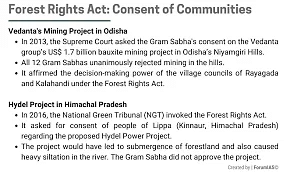
- Consent clause: There are concerns over the provision in the new rules that proposes to do away with the consent clause for diversion of forest land for other purposes.
- NCST says that the FCR 2022 had done away with the clause to mandatorily seek consent of Gram Sabhas before the Stage 1 clearance, leaving this process to be done later even after Stage 2 clearance.
- Violation of rights: Project proponents receiving partial clearance will be pushing State and Union Territory governments for diversion at the earliest and it would seriously impact the process of recognition of rights under the FRA.
- FRA non-compliance: The Commission has pointed out that between 2009 and 2018 of the 128 applications for forest diversion for mining, 74 were cleared at the Stage 2 and 46 at the Stage 1 and none of the rejections were based on FRA non-compliance.
- The new Rules will only increase such violations.
- Resettlement: Once Forest clearance is accorded then the dwellers’ claims of resettlement will be ignored.
Counter Argument (Government’s position)
- The government says that the new rules are framed under the Forest (Conservation) Act, 1980 and that the NCST’s apprehension of these rules being in violation of the Forest Rights Act (FRA), 2006 is not legally tenable.
- Under Rule 9(6)(b)(ii): the government says the FCR 2022 already provides for diversion of forest land only after fulfilment and compliance of all provisions, including settlement of rights under the Forest Rights Act and does not bar or infringe upon the operation of other laws mandating consent of Gram Sabhas.
- The new rules will allow parallel processing of the proposals and eliminate the redundant processes.
- The rules make a provision for private parties to cultivate plantations and sell them as land to companies who need to meet compensatory afforestation targets.
- It will help India increase forest cover as well as solve the problems of the States of not finding land within their jurisdiction for compensatory purposes.
Way forward
- The requirement for consent and recognition of rights prior to Stage I clearance in 2014 and 2017 Rules provided a legal space for ensuring completion of the processes for recognition and vesting of rights under the FRA in areas where forests are being diverted.
Forest and Tree Cover in India
Why in News?
India is lagging behind in the targets to increase the number and quality of tree- and forest-cover plantations set in the National Mission for a Green India (GIM).
- States with significant shortfall in tree cover include Andhra Pradesh, Uttarakhand, Madhya Pradesh, and Kerela.
What is the National Mission for a Green India?
- GIM is one of the eight Missions under the National Action Plan on Climate Change.
- It aims at protecting, restoring and enhancing India’s forest cover and responding to climate change.
- The target under the Mission is 10 million hectares (Mha) on forest and non-forest lands for increasing the forest/tree cover and to improve the quality of existing forest.
- The Ministry of Environment, Forest and Climate Change supports the States/Union Territories for carrying out afforestation activities through this Centrally Sponsored Scheme.
- Improving tree cover is critical to sequester carbon and bolster India’s carbon stocks as part of its international commitments to mitigate greenhouse gas emissions.
What is the Status of Forests in India?
- About:
- As per the India State of Forest Report-2021, forest and tree cover in the country increased by 2,261 square kilometres since the last assessment in 2019.
- India’s total forest and tree cover was 80.9 million hectares, which accounted for 24.62% of the geographical area of the country.
- The report said 17 States and Union Territories had more than 33% of their area under forest cover.
- Madhya Pradesh had the largest forest cover, followed by Arunachal Pradesh, Chhattisgarh, Odisha and Maharashtra.
- The top five States in terms of forest cover as a percentage of their total geographical area were Mizoram (84.53%), Arunachal Pradesh (79.33%), Meghalaya (76%), Manipur (74.34%) and Nagaland (73.90%).
- Issues Associated with Forests in India:
- Shrinking Forest Cover: According to the National Forest Policy of India, the ideal percentage of total geographical area under forest should be at least 33% to maintain ecological stability.
- However, it currently covers just 24.62% of the country’s land and is shrinking rapidly.
- Resource Access Conflict: There is often conflict between the interests of local communities and those of commercial interests, such as pharmaceutical industries or timber industries.
- This can lead to social tensions and even violence, as different groups struggle to access and use the resources of the forests.
- Climate Change: Forest disturbances caused by climate change, including insect outbreaks, invasive species due to climate led migration, wildfires, and storms, reduce forest productivity and change species distribution.
- By 2030, 45-64% of forests in India will experience the effects of climate change and rising temperatures.
- Government Initiatives for Forest Conservation:
- National Afforestation Programme
- Environment Protection Act of 1986
- Scheduled Tribes and Other Traditional Forest Dwellers (Recognition of Forest Rights) Act, 2006
How can India Enhance its Forest Cover?
- Utilising Technology for Conservation: Technology can be utilised such as remote sensing, to monitor and track forest cover, forest fire and identify areas in need of protection.
- Also, Potential resource mapping can be done in unexplored forest areas, and they can be brought under scientific management and sustainable resource extraction maintaining density and forest health
- Dedicated Forest Corridors: For safe intrastate and interstate passage of wild animals and protecting their habitat from any external influence, dedicated forest corridors can be maintained giving a message of peaceful-co existence.
- Promoting Agroforestry: This practice involves integrating trees and forest-based products into farming systems. This can help increase forest cover and also provide farmers with additional income and resources.'
Eco-Sensitive Zones
Why in News?
Recently, Eco-sensitive Zones have been met with resistance from protests claiming that compliance with the Environmental Protection Act 1986 and the Wildlife Protection Act 1972 has led authorities to disregard the rights of forest communities and negatively affect their way of life and livelihood.
What is Eco Sensitive Zones?
- About:
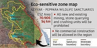
- The National Wildlife Action Plan (2002-2016) of the Ministry of Environment, Forest and Climate Change (MoEFCC) stipulated that state governments should declare land falling within 10 km of the boundaries of national parks and wildlife sanctuaries as eco-fragile zones or Eco-Sensitive Zones (ESZs) under the Environmental (Protection) Act, 1986.
- While the 10-km rule is implemented as a general principle, the extent of its application can vary. Areas beyond 10 km can also be notified by the Union government as ESZs, if they hold larger ecologically important “sensitive corridors”.
- Activities Around ESZs:
- Prohibited Activities: Commercial mining, saw mills, industries causing pollution (air, water, soil, noise etc), establishment of major hydroelectric projects (HEP), commercial use of wood.
- Regulated Activities: Felling of trees, establishment of hotels and resorts, commercial use of natural water, erection of electrical cables, drastic change of agriculture system, e.g., adoption of heavy technology, pesticides etc, widening of roads.
- Permitted Activities: Ongoing agricultural or horticultural practices, rainwater harvesting, organic farming, use of renewable energy sources, adoption of green technology for all activities.
Significance of ESZs
- Minimise the Impact of Development Activities:
- To minimise the impact of urbanization and other developmental activities, the areas adjacent to protected areas have been declared as Eco-Sensitive Zones.
- In-situ Conservation:
- ESZs help in in-situ conservation, which deals with conservation of an endangered species in its natural habitat, for example the conservation of the One-horned Rhino of Kaziranga National Park, Assam.
- Minimise Forest Depletion and Man-Animal Conflict:
- Eco-Sensitive Zones minimise forest depletion and man-animal conflict.
- The protected areas are based on the core and buffer model of management, through which local area communities are also protected and benefitted.
- Minimise the Negative Impact on the Fragile Ecosystems:
- The purpose of declaring eco-sensitive zones around protected areas is to create some kind of a 'Shock Absorber' for the protected area.
- They also act as a transition zone from areas of high protection to areas involving lesser protection.
Challenges Associated with ESZs
- Climate change:
- Climate change has generated land, water and ecological stress on the ESZs.
- For example, frequent forest fires or the Assam floods which badly affected the Kaziranga National Park and its wildlife.
- Encroachment of Forest Rights:
- Sometimes, execution of The Environmental Protection Act 1986 and the Wildlife Protection Act 1972 makes the authorities ignore forest communities' rights and impact their life and livelihood.
- It also includes dilution of rights provided to gram sabha for developmental clearances.
- Recognition of forest rights and gram sabha’s consent were preconditions for considering proposals under The Forest Rights Act 2006 to divert forest land for non-forestry purposes – until the MoEFCC did away with them in 2022.
Way Forward
- Community Engagement: It is important to involve local communities in the decision-making process for the management of ESZs.
- This can be done through the formation of community-based organisations, such as user groups or conservation committees, that are responsible for managing and protecting the resources found in these areas.
- Gram sabha must be empowered with a decision-making authority in case of developmental projects.
- Alternate Livelihood support: It is important to provide alternative livelihood options for local communities who depend on the resources found in ESZs for their livelihoods.
- This can include training programs and financial support for alternative livelihoods such as eco-tourism, horticulture, and sustainable agriculture.
- Promoting Eco Restoration: Afforestation and reforestation of degraded forest, regeneration of lost habitats, reducing climate change impacts by promoting carbon footprints and through education, is needed.
Etalin Hydroelectric Project
Why in News?
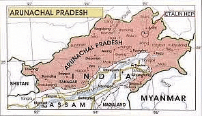
Recently, the Etalin hydroelectric project in Arunachal Pradesh has been scrapped in its present form.
- The plan combined two run-of-the-river schemes with limited storage requiring concrete gravity dams on rivers Tangon and Dri.
- It ran into several controversies since its inception in 2008 over concerns of ecological damage, forest invasion and tribal displacement.
What is the Significance of Dir and Tangon River?
- The Dir and Tangon river, both tributaries of the Dibang River (tributary of Brahmaputra) in Arunachal Pradesh, India, have the following significance:
- Hydrological: Both rivers contribute to the overall hydrology of the region by providing water for irrigation and hydropower generation.
- Ecological: The Dir and Tangon rivers support a diverse array of plant and animal life, including rare and endangered species.
- Tourist Attraction: The scenic beauty of the Dir and Tangon rivers, along with the Dibang, is a major tourist destination.
What are the Concerns Raised Around the Etalin Hydel Project
- Environmental Impact: The project would involve the construction of a large dam on the Dibang River, which would submerge a large area of forest and wildlife habitat.
- This could lead to the displacement of local communities, and have significant impacts on the region's biodiversity.
- Displacement of Local Communities: The project would displace thousands of people from their homes and livelihoods, many of whom are from indigenous communities who rely on the Dibang River for their livelihoods.
- Impact on River Ecosystem: The project would change the natural flow of the river and affect the fish migration and breeding.
- This would have a negative impact on local communities who rely on fishing for their livelihoods.
- Geological and Seismic Risks: The South Asia Network on Dams, Rivers and People (SANDRP) highlighted the geological and seismic risks and threats to biodiversity in 2015, when environmental clearance (EC) to the project was underway.
- Recent Development of Issue: The Forest Advisory Committee (FAC) has asked the Arunachal Pradesh government to go back to the drawing board and submit the plan of project again.
Way Forward
- Community-led Approach: The local population of the region should be consulted and should have participation in the decision making to ensure that the final decision making should reflect their concerns.
- Demarcation of Ecological Sensitive Areas: The areas which are at risk of loss of biodiversity should be properly delineated to ensure that they remain undisturbed.
- Environment Impact assessment (EIA): A proper and complete assessment of the impact of the project on the local environment should be studied comprehensively.
Water Crisis Due to Dam Sedimentation
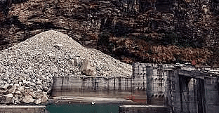
Why in News?
The United Nations Institute for Water, Environment and Health showed in its report that about 50,000 large dams across the world will lose 24-28% water storage capacity by 2050 due to sediment trapped in them.
- These water reservoirs have already lost about 13-19% capacity to sedimentation.
- The United Kingdom, Panama, Ireland, Japan and Seychelles will experience the highest water storage losses by 2050 from 35-50% of their original capacities.
What is Sedimentation with Respect to Dams?
- Sedimentation in dams refers to the accumulation of sediments, such as sand, gravel, and silt, at the bottom of a reservoir created by a dam.
- This sediment can build up over time, reducing the overall storage capacity of the reservoir.
- To maintain the capacity of the reservoir, the sediment may need to be removed through a process called dredging.
What is Dredging?
- Dredging is the process of removing sediments, such as sand, gravel, and silt, that has accumulated at the bottom of a reservoir.
- It can be done using various methods, such as mechanical dredging with a dredge machine or hydraulic dredging with a high-pressure water jet.
- The sediment removed during dredging is typically disposed of in a designated area away from the dam.
What are the Causes of Sedimentation?
- Erosion Upstream of the Dam: When soil and rock is washed away from the area upstream of the dam, it can be carried downstream and deposited in the reservoir.
- Runoff from Urban and Agricultural Areas: The increased use of land for human activities, such as urbanization and agriculture, can lead to increased runoff of sediment into the reservoir.
- Natural Processes: Sedimentation can also occur naturally through processes such as weathering and erosion.
- Climate Change: Climate change causes more intense and frequent rainfall events and also causes snowmelt earlier which can lead to increased erosion and sediment runoff into the reservoir.
- Deforestation: Trees help to hold the soil together and prevent erosion, so when forests are removed or degraded, there is a greater risk of sediment runoff into the reservoir.
- Poor Dam Maintenance: Lack of maintenance and repairs can also lead to sedimentation, as the dam's structure can become damaged, allowing sediment to enter the reservoir.
What are the Consequences of Dam Sedimentation?
- Environmental:
- Reduced water storage capacity in the reservoir, which can lead to water shortages for downstream users and the loss of habitat for aquatic species.
- Increased risk of dam failure as the sediment can cause the dam to become unstable.
- Economic:
- Increased cost of maintenance and dredging to remove the sediment.
- Loss of hydroelectric power generation due to reduced water flow through the dam.
- Reduced irrigation and water supply for agriculture and industry.
- Loss of revenue from recreational activities such as fishing and boating if the reservoir is no longer able to support them.
- Damage to Dam Structure and Turbines:
- The accumulation of sediment at the bottom of the reservoir can cause scouring, or erosion, of the dam's foundation, which can weaken its structural integrity and increase the risk of failure.
- Sediment can also clog the turbine intake, which can reduce the efficiency of hydroelectric power generation and require costly maintenance to remove the sediment.
- The sediment can also cause abrasion on the turbine blades which can lead to damage and reduce their efficiency.
- While sediment helps maintain the aquatic ecosystem, poor management can lead to nutritional disbalances causing eutrophication and other disruptions in the water pool of the dam, as well as damages in habitations downstream.
Way Forward
- Regular Inspections and Monitoring: Dams are required to be regularly inspected and monitored for signs of structural weakness, erosion, and other potential issues. This includes both visual inspections and instrument-based monitoring, such as monitoring the dam's foundation for movement.
- Emergency Action Plans: Dams are required to have emergency action plans in place to respond to potential incidents, such as dam failure or excessive flooding. These plans outline the actions to be taken in the event of an emergency, including evacuation procedures and emergency response procedures.
- Environmental Impact Assessment: Dams are required to undergo environmental impact assessments (EIA) to evaluate the potential impacts of the dam on the surrounding environment. This includes assessing the impact on wildlife, aquatic species, and downstream communities.
- Public Consultation: Dams are required to involve public consultation and participation in the decision-making process, including providing information and opportunities for public comment on the proposed dam.
New Plateau in the Western Ghats'
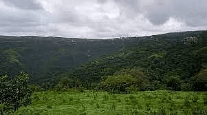
Why in News?
Recently, a rare low-altitude basalt plateau discovered in Maharashtra in the Western Ghats can help study the effects of climate change on species survival and increase awareness of the conservation needs of rock outcrops and their immense biodiversity value in the global context.
What are the Important Findings About the Plateau?
- Low-Altitude Basalt Plateau: This is the fourth type of plateau to be identified in the region; the previous three are laterites at high and low altitudes and basalt at high altitudes.
- Diverse Biodiversity: During the survey of the plateau, 76 species of plants and shrubs from 24 different families were reported. This is considered an important discovery, as the plateau shares the vegetation with the three other rock outcrops, simultaneously holding a few unique species.
- This gives a unique model system to study the species' interactions in varying environmental conditions.
Western Ghats: What's Important to Know?
- About:
- Western Ghats consists of a chain of mountains running parallel to India’s Western Coast and passing from the states of Kerala, Maharashtra, Goa, Gujarat, Tamil Nadu and Karnataka.
- The Western Ghats is one of four global biodiversity hotspots in India.
- The other three are the Himalayas, the Indo-Burma region and the Sundaland (includes the Nicobar Islands).
- It is recognized as a UNESCO World Heritage Site.
- Significance:
- The Ghats influence the Indian monsoon weather patterns that mediate the warm tropical climate of the region.
- They act as a barrier to rain-laden monsoon winds that sweep in from the south-west.
- Western Ghats are home to tropical evergreen forests, as well as to 325 globally threatened species.
- Plateaus are the dominant landscapes in the Western Ghats, significant because of the predominance of endemic species.
Kelp Forests on Decline
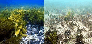
Why in News?
- According to experts, Global Kelp forests declining at 1.8% annually.
What are the Kelp Forests?
- Kelp forests are underwater areas with a high density of kelp, which covers a large part of the world's coastlines.
- Smaller areas of anchored kelp are called kelp beds.
- Kelp are not plants, but rather extremely large brown algae, and many different species of kelp make up kelp forests.
Features of Kelp Forests
- Kelp thrives in cold, nutrient-rich waters.
- Because kelp attaches to the seafloor and eventually grows to the water’s surface and relies on sunlight to generate food and energy, kelp forests are always coastal and require shallow, relatively clear water.
- Growth:
- Some kelp species can measure up to 150 feet (45 m) long. If living in ideal physical conditions, kelp can grow 18 inches (45 cm) a day.
- Habitat:
- Kelps usually live further from the tropics than coral reefs, mangrove forests, and warm-water seagrass beds, so kelp forests do not overlap with those systems.
- Global presence:
- Kelp forests grow predominantly along the Eastern Pacific Coast, from Alaska and Canada to the waters of Baja, California.
Significance of the Kelp Forests
- They are recognized as one of the most productive and dynamic ecosystems on Earth.
- Kelps cover 25 percent of the world’s coastlines and provide food and shelter for fish, invertebrates and marine mammal species.
- They also offer crucial services such as carbon sequestration and erosion control, according to scientists.
- Giant Kelp:
- Giant kelp is harvested from kelp forests and used as a binding agent in products like ice cream, cereal, ranch dressing, yogurt, toothpaste, lotion and more.
Threats to Kelp Forest
- Climate change and human-induced stressors:
- Kelps are increasingly threatened by climate change, eutrophication and shoreline development, among other human-induced stressors.
- Destructive fishing practices, coastal pollution, and accidental damage caused by boat entanglement are known to negatively affect kelp forests.
- Warming of oceans:
- Warmer than normal summers and seasonal changes to currents that bring fewer nutrients to kelp forests combine to weaken kelps and threaten their survival in some years.
- Bryozoa:
- One such threat is from bryozoa, moss animals that grow as mats on kelps. They drive the seaweed to sink into the seafloor and disintegrate.
- The bryozoa outbreak can be linked to high temperatures as high temperature and kelp density results in more bryozoan.
- Dense kelp beds in warmer and less wave-exposed sites are more susceptible to bryozoan outbreaks
- Storms:
- Strong individual storms can wipe out large areas of kelp forest, by ripping the kelp plants from the seafloor.
Way ahead
- While it is unlikely that in situ protection could halt declines of rear edge kelp populations under scenarios of warming, their unique genetic diversity could be protected and studied ex situ in culture banks for use in restoration, hybridisation or assisted adaptation strategies
State of Indian Dams
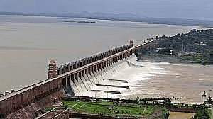
Why in News?
According to a new Comptroller and Auditor General of India (CAG) report, Gandhi Sagar Dam on Chambal River (Madhya Pradesh) is in need of immediate repair.
- Absence of regular checks, non-functional instruments and choked drains are the major problems plaguing the dam for years.
Key Points
- About:
- India is ranked third in the world in terms of building large dams.
- Of the over 5,200 large dams built so far, about 1,100 large dams have already reached 50 years of age and some are older than 120 years.
- The number of such dams will increase to 4,400 by 2050.
- This means that 80% of the nation’s large dams face the prospect of becoming obsolete as they will be 50 years to over 150 years old.
- The situation with hundreds of thousands of medium and minor dams is even more dangerous as their shelf life is even lower than that of large dams.
- Examples: Krishna Raja Sagar dam was built in 1931 and is now 90 years old. Similarly, Mettur dam was constructed in 1934 and is now 87 years old. Both these reservoirs are located in the water scarce Cauvery river basin.
Issues with India’s Aging Dam
- Built according to the Rainfall Pattern:
- Indian dams are very old and built according to the rainfall pattern of the past decades. Erratic rainfall in recent years has left them vulnerable.
- But the government is equipping the dams with information systems like rainfall alerts, flood alerts, and preparing emergency action plans to avoid all sorts of mishaps.
- Decreasing Storage Capacity:
- As dams age, soil replaces the water in the reservoirs. Therefore, the storage capacity cannot be claimed to be the same as it was in the 1900s and 1950s.
- The storage space in Indian reservoirs is receding at a rate faster than anticipated.
- Flawed Design:
- Studies show that the design of many of India’s reservoirs is flawed.
- Indian reservoirs are designed with a poor understanding of sedimentation science.
- The designs underestimate the rate of siltation and overestimate live storage capacity created.
- High Siltation Rates:
- It refers both to the increased concentration of suspended sediments and to the increased accumulation (temporary or permanent) of fine sediments on bottoms where they are undesirable.
- Consequences:
- Impacting Food Security: When soil replaces the water in reservoirs, supply gets choked. In this case, the cropped area may begin receiving less and less water as time progresses.
- As a result, the net sown water area either shrink in size or depends on rains or groundwater, which is over-exploited.
- Impacting Farmers’ Income: As crop yield may get affected severely, it would disrupt the farmer’s income.
- Moreover, water is a crucial factor for crop yield and credit, crop insurance, and investment.
- Increased Flooding: The flawed siltation rates reinforce the argument that the designed flood cushion within several reservoirs across many river basins may have already depleted substantially, due to which floods have become more frequent downstream of dams.
Need of the Dam Safety
- To Safeguards People Lives:
- Ageing dams can serve as a cause of concern for people living in the areas nearby.
- Safeguarding Investment:
- Safety of dams is also important for safeguarding the huge public investment in this critical physical infrastructure, as also, for ensuring continuity of benefits derived from the dam projects and national water security.
- Tackle India’s water crisis:
- Safety of dams is also important in the emerging scenario of India’s water crisis, linked with its growing population, as also the climate change.
- Related Initiatives:
- Dam Safety Bill, 2019: Rajya Sabha has recently passed the Dam Safety Bill, 2019.
- The bill provides for surveillance, inspection, operation and maintenance of the specified dam, for prevention of dam failure related disaster, and also makes provision for institutional mechanisms to ensure their safe functioning.
- Dam Rehabilitation and Improvement Project (DRIP Phase II): To improve the safety and performance of selected existing dams and associated appurtenances in a sustainable manner.
Way Forward
- The most important aspect in ensuring dam safety is the existence of accountability and transparency while taking into consideration the views of the real stakeholders--the people living downstream from the dams, who are the most at-risk group in case of a breach.
- In terms of the operational safety, the rule curve, that decides how a dam is supposed to be operated and is created when a dam is proposed, needs to be upgraded at regular intervals on the basis of environmental changes such as siltation and rainfall pattern since these would change the frequency and intensity of incoming flood into the dam as well as the spillway capacity.
- The rule curve also needs to be in the public domain so that the people can keep a check on its correct functioning and can raise questions in its absence.
- Moreover, in India every river has multiple dams along its course, so a cumulative assessment of every upstream and downstream dam needs to be in place to ensure dam safety in terms of operations.
|
95 videos|234 docs|52 tests
|


