Geography - 1 | Current Affairs & Hindu Analysis: Daily, Weekly & Monthly - UPSC PDF Download

Ocean Circulation and Climate Change
Why in News?
Recently, a study published in Nature Communications has drawn attention due to its surprising findings regarding the ocean's influence on climate change. This research indicates that a weakening of ocean circulation may lead to increased levels of atmospheric CO2, challenging previous assumptions in the field.
Key Takeaways
- Ocean overturning circulation functions as a global conveyor belt, redistributing water and nutrients.
- Weaker ocean circulation could contribute to higher atmospheric CO2 levels, contrary to earlier beliefs.
- Factors like melting ice sheets and temperature changes are predicted to weaken ocean circulation.
- New research uncovers a feedback mechanism involving ocean circulation and nutrient cycles that elevates CO2 levels.
Additional Details
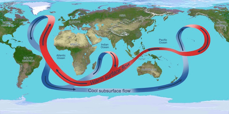
- Meridional Overturning Circulation (MOC): A crucial element of global ocean circulation that transports water, heat, salt, carbon, and nutrients in a north-south direction. It is vital for regulating the Earth's climate.
- Mechanism of MOC:
- Northward Flow: Warm, salty surface water moves from the South Atlantic toward the Nordic Seas, where it cools and sinks to form deep water currents.
- Antarctic Contribution: Denser waters near Antarctica flow north along the ocean floor into the North Atlantic, where they rise and mix before returning south.
- Significance: The MOC is responsible for approximately two-thirds of the ocean’s northward heat transport, influencing both regional and global climate patterns.
- Cycle Duration: The full cycle of the MOC, often referred to as the oceanic conveyor belt, takes about 1,000 years for a water parcel to complete its journey.
This new understanding of ocean circulation underscores the need for a reevaluation of the ocean's role in climate change mitigation strategies, highlighting the potential for increased atmospheric CO2 levels as circulation weakens, thereby aggravating global warming.
Gulf Stream and Climate Sensitivity
 Why in News?
A recent study published in Nature has highlighted that the strength of the Gulf Stream was significantly greater during the last ice age, approximately 20,000 years ago. This increase in strength was attributed to more powerful winds in the subtropical North Atlantic. The findings indicate that the Gulf Stream's strength is sensitive to shifts in wind patterns, which may have implications for future climate scenarios if these winds weaken due to climate change.
Key Takeaways
- The research analyzed fossil foraminifera from sediment cores off the coasts of North Carolina and Florida to assess the prehistoric strength of the Gulf Stream.
- During the last ice age, the Gulf Stream was found to be twice as deep and fast compared to its current state.
- Despite the Gulf Stream's strength, the global climate during that period was considerably colder than today.
- A potential weakening of the Gulf Stream in the future could inhibit tropical heat from reaching Europe, which may result in cooler temperatures across the continent and increased sea levels in North America.
Additional Details
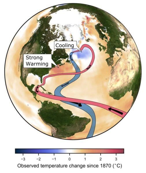
- Atlantic Meridional Overturning Circulation (AMOC): The Gulf Stream is a crucial component of the AMOC, which involves deep water formation and wind patterns that are essential for regulating climate.
- Climate change-related disruptions, such as the melting of glacial ice from Greenland, could weaken the AMOC, potentially cooling Europe by 10 to 15 degrees Celsius and impacting agriculture and weather patterns.
- The AMOC should be understood as interconnected loops (subtropical and subpolar) rather than a simple conveyor belt, indicating that different regions of the AMOC may respond uniquely to climate change.
In summary, the strength of the Gulf Stream and its connection to the AMOC is vital for understanding climate sensitivity. Future changes in wind patterns and ocean currents could have profound effects on regional and global climates.
Ladakh's Rock Varnish
 Why in News?
Recently, significant discoveries were made in Ladakh regarding magnetofossils, which are fossilized magnetic particles originating from magnetotactic bacteria. These particles were found within the layers of rock varnish, a dark brown to black coating that typically forms on stable, subaerially exposed rock surfaces in arid and semi-arid environments.

Key Takeaways
- The analysis of rock varnish samples from Ladakh showed elevated levels of oxidized manganese (Mn4+) and carboxylic acid functionality, indicating the presence of organic signatures.
- This research suggests that the rock varnish in Ladakh, which may serve as a Martian analogue site, has enriched concentrations of magnetic minerals likely originating from biological sources.
- Magnetic minerals can retain a record of the Earth's magnetic field from their formation period, and are commonly found in various geological materials like rocks, sediments, and soils.
Additional Details
- Significance of the Study: The findings provide valuable insights into astrobiology by illustrating how life can exist in extreme environments, such as the cold desert of India, known as Ladakh.
- The results are crucial for future plans by the Indian Space Research Organisation (ISRO) and other space agencies regarding Mars exploration, where identifying habitable conditions is one of the main objectives.
- Identifying biotic signatures in rock varnish is essential for scientists as it aids in targeting potential biosignatures on Mars and other celestial bodies, contributing to the ongoing search for extraterrestrial life.
- A biosignature refers to any characteristic, element, molecule, or feature that can provide evidence of past or present life.
In conclusion, the discoveries related to Ladakh's rock varnish not only enhance our understanding of Earth's geological processes but also play a pivotal role in astrobiological research, particularly in the context of exploring life beyond our planet.
Transboundary Rivers of India
 Why in News?
Bangladesh has recently faced severe floods, leading to concerns that the water might be coming from the Dumbur dam in Tripura, India. However, the Indian government has clarified that the flooding is caused by heavy rainfall in the larger catchment areas of the Gumti River, which flows through both nations, rather than the dam’s water release.
Key Takeaways
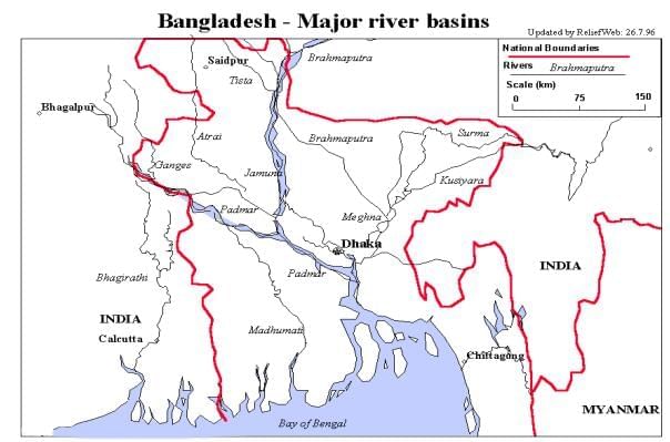
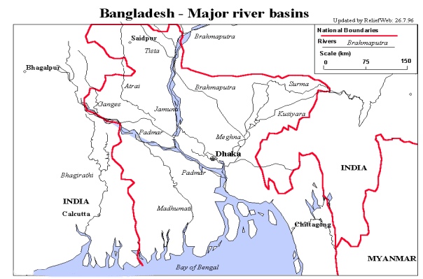
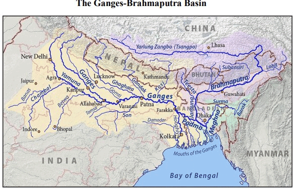
- India and Bangladesh share 54 rivers, with India having the most rivers flowing into the Bay of Bengal via Bangladesh.
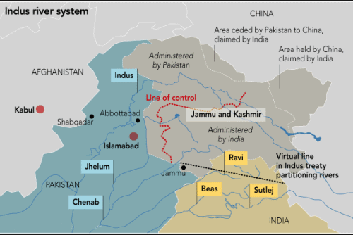
- Major rivers include the Ganges, Teesta, Brahmaputra, and Indus, which are critical for water management and international relations.
Additional Details
- Ganges (Padma in Bangladesh):This major river flows from India into Bangladesh, traversing the Gangetic plain of North India. Its tributaries include:
- Left-bank: Gomti, Ghaghara, Gandak, Kosi
- Right-bank: Yamuna, Son, Punpun
- Teesta: Originating in the Himalayas, it flows through Sikkim and West Bengal before merging with the Brahmaputra. Bangladesh advocates for a fair allocation of its waters, similar to the 1996 Ganga Water Treaty.
- Brahmaputra: Originates from the Chemayungdung glacier in Tibet and forms a natural border between India and Bangladesh, eventually joining the Ganga to form the Padma River.
- Indus River: A trans-boundary river that originates in Tibet, flows through Kashmir, and continues into Pakistan, emptying into the Arabian Sea. The Indus Waters Treaty of 1960 governs its water rights.
In conclusion, the management of transboundary rivers in India presents significant challenges and opportunities, requiring cooperation among neighboring countries to ensure equitable water sharing and address environmental concerns.
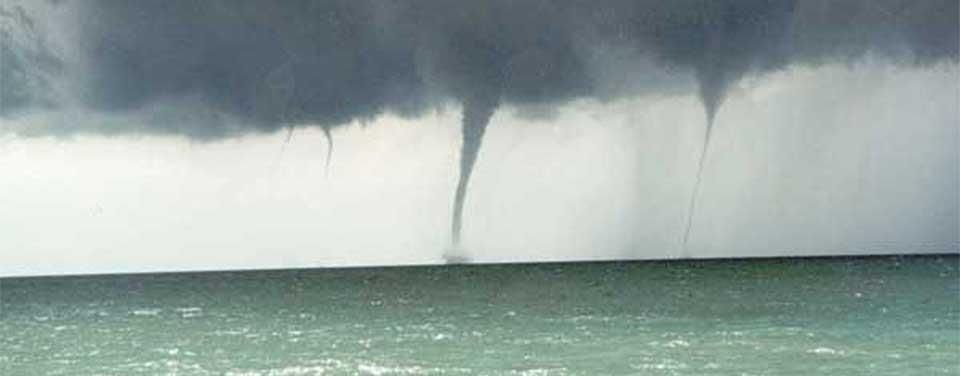
What are Waterspouts?
 Why in News?
Recently, a luxury yacht sank off the coast of Sicily, Italy, during a violent storm, resulting in one confirmed death and six individuals missing, possibly due to a waterspout.
Key Takeaways
- Waterspouts are rotating columns of air that form over water bodies.
- They are a weaker version of tornadoes, typically lasting 5-10 minutes.
- The average diameter of a waterspout is around 165 feet (50 meters) with wind speeds reaching up to 100 km/h (60 mph).
Additional Details
- Formation of Waterspouts: Waterspouts can form through two main types:
- Fair-weather waterspouts: Occur when cool air flows over warm water, drawing water upwards.
- Tornadic waterspouts: Form during thunderstorms and may start as tornadoes over land.
- Waterspouts develop through a five-stage process:
- Dark spot: A light-colored disk appears on the water’s surface.
- Spiral pattern: Bands of light and dark colors spiral outward.
- Spray ring: A swirling mass of sea spray resembling a hurricane's eye forms.
- Mature vortex: A funnel extends from the water surface to the clouds.
- Decay: The waterspout weakens due to warm air disruptions.
- Waterspouts are most common in tropical and subtropical regions, but can occur globally including Europe, the Middle East, and Antarctica.
Research from the University of Barcelona has indicated a link between warmer sea surface temperatures and increased occurrences of waterspouts. For example, the water near Sicily has been observed to be 2.5 to 3 degrees Celsius warmer than the average from 1990 to 2020, potentially leading to more frequent waterspout formations in the area.
What is ENSO (El Niño-Southern Oscillation)?
The El Niño-Southern Oscillation (ENSO) is a climate pattern marked by variations in winds and sea surface temperatures in the tropical eastern Pacific Ocean, significantly impacting the climates of the tropics and subtropics. The warming phase is termed El Niño, while the cooling phase is referred to as La Niña.
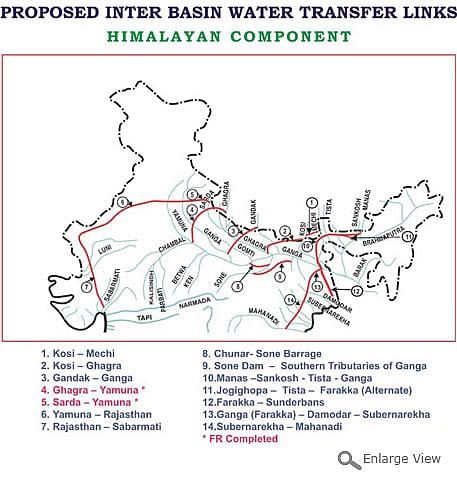
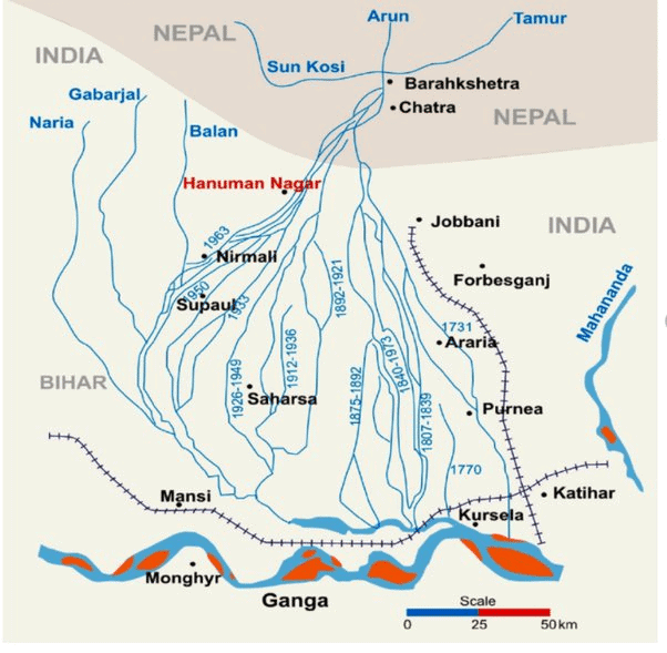
Kosi-Mechi River Linking Project
 Why in News?
The Kosi-Mechi River Linking Project, part of India’s ambitious National Perspective Plan (NPP) for interlinking rivers, has sparked controversy. Flood victims in Bihar have protested against its implementation, arguing that while the project aims to enhance irrigation, it does not adequately address the pressing issue of annual flood control, which severely impacts local communities.
Key Takeaways
- The project connects the Kosi River with the Mechi River, affecting regions in Bihar and Nepal.
- It aims to irrigate 4.74 lakh hectares of land and supply 24 million cubic meters of water for domestic and industrial use.
- Upon completion, it is expected to release an additional 5,247 cubic feet per second (cusecs) of water from the Kosi barrage.
- Oversight is provided by the National Water Development Agency (NWDA) under the Union Ministry of Jal Shakti.
Additional Details
- Project Purpose: The primary goal is to enhance irrigation for 215,000 hectares in the Mahananda river basin during the Kharif season.
- Despite its irrigation focus, critics point out the project lacks a significant flood control feature, which is critical in flood-prone regions.
- The additional water release is minimal compared to the barrage's total capacity, raising concerns about its effectiveness in flood prevention.
- Local communities have experienced devastating flooding and erosion, which the project does not sufficiently address.
The Kosi River, known as the 'Sorrow of Bihar,' originates in the Himalayas and has a history of shifting its course, leading to extensive agricultural damage. Meanwhile, the Mechi River, flowing through both Nepal and India, is a significant tributary of the Mahananda River.
National Perspective Plan for Interlinking Rivers
- The NPP, formulated in 1980, aims to develop water resources through inter-basin water transfer.
- It consists of the Himalayan and Peninsular Rivers Development Components.
- 30 link projects have been identified, with notable ones under each component.
- The NPP seeks to manage flood risks and address water shortages in various states while enhancing irrigation and agricultural productivity.
- Despite its intentions, the plan faces challenges such as incomplete feasibility studies and potential disputes over water sharing among states.
Way Forward
- Implement comprehensive floodplain zoning to restrict settlement in high-risk areas.
- Fortify embankments along the Kosi River to mitigate flooding risks.
- Ensure equitable distribution of project benefits to both flood-prone and water-scarce regions.
- Consider the National Waterways Project as an alternative to reduce state disputes and provide a cost-effective solution for irrigation and power generation.
In conclusion, the Kosi-Mechi River Linking Project presents both opportunities for irrigation and challenges related to flood management. Its alignment with the broader goals of the National Perspective Plan highlights the complexity of water resource management in India.
Latitudinal Variation in Sun's Rotation Speed
 Why in News?
Recently, Indian astronomers achieved a significant milestone by mapping the variation in the Sun's rotation speed from its equator to its poles for the first time. This groundbreaking study utilized over a century of daily solar observations collected at the Kodaikanal Solar Observatory in Tamil Nadu.
Key Takeaways
- The rotation speed of the Sun's chromosphere has been successfully mapped.
- The Sun exhibits differential rotation, spinning faster at the equator compared to its poles.
- Data was gathered using solar plages and network cells, which provided insights across various latitudes.
Additional Details
- Chromosphere: This is a thin layer of plasma located between the Sun’s visible surface (the photosphere) and the corona (the Sun’s upper atmosphere).
- Differential Rotation: The Sun’s equatorial region completes one rotation in approximately 25 days, while the poles take about 35 days. At the equator, the rotation rate is 13.98 degrees per day, while it slows to 10.5 degrees per day at 80 degrees latitude.
- Kodaikanal Solar Observatory: The observatory has been instrumental in this research, utilizing data on solar plages—brighter regions characterized by weaker magnetic fields—and network cells, which are larger than individual sunspots but smaller than sunspot groups.
- Unlike sunspots, plages and network cells are always present on the Sun's surface, allowing scientists to study the rotation rate even at the poles.
- Sunspots: These are cooler regions on the Sun's surface that appear dark when compared to surrounding areas.
Understanding the differential rotation of the Sun is crucial as it plays a key role in the solar dynamo, influences the 11-year solar cycle, and is connected to periods of heightened solar activity, which can lead to magnetic storms affecting Earth.
Key Facts About the Sun's Atmosphere
- Photosphere: The visible surface of the Sun, marking the boundary between the interior and the atmosphere.
- Chromosphere: An irregular layer above the photosphere where temperatures increase from 6000°C to about 20,000°C.
- Transition Region: A thin, irregular layer that separates the hot corona from the cooler chromosphere.
- Corona: The outer atmosphere of the Sun, significantly hotter than the chromosphere or photosphere.
- The solar wind, an outward flow of charged particles originating from the corona, extends far into space, influencing planetary atmospheres and causing phenomena such as auroras on Earth.

|
63 videos|5408 docs|1146 tests
|
FAQs on Geography - 1 - Current Affairs & Hindu Analysis: Daily, Weekly & Monthly - UPSC
| 1. What is ocean circulation and how does it affect climate change? |  |
| 2. How does the Gulf Stream influence climate sensitivity? | |
| 3. What is Ladakh's rock varnish, and what does it indicate about the region's climate history? | |
| 4. What are transboundary rivers in India, and why are they significant? | |
| 5. What are waterspouts, and how do they form? | |


Geography - 1 | Current Affairs & Hindu Analysis: Daily
,past year papers
,study material
,Free
,Weekly & Monthly - UPSC
,ppt
,Semester Notes
,Sample Paper
,Important questions
,MCQs
,video lectures
,Previous Year Questions with Solutions
,shortcuts and tricks
,practice quizzes
,Extra Questions
,Viva Questions
,Geography - 1 | Current Affairs & Hindu Analysis: Daily
,Exam
,Objective type Questions
,Weekly & Monthly - UPSC
,mock tests for examination
,Summary
,Weekly & Monthly - UPSC
,Geography - 1 | Current Affairs & Hindu Analysis: Daily
;


Geography - 1 Free PDF Download
Importance of Geography - 1
Geography - 1 Notes
Geography - 1 UPSC Questions
Study Geography - 1 on the App
|
© EduRev
|
Education Revolution
|


|


within 7 days!