Geography - 2 | Current Affairs & Hindu Analysis: Daily, Weekly & Monthly - UPSC PDF Download
| Table of contents |
|
| Landslide Induced Earthquake in Greenland |
|
| Poleward Shift of Atmospheric Rivers |
|
| Cyclone Dana |
|
| Volcanic Eruption and Ionospheric Disturbances |
|
| Aurorae in Ladakh |
|

Landslide Induced Earthquake in Greenland
 Why in News?
Recently, scientists observed unusual seismic waves globally, attributed to landslides in Greenland that persisted for nine days. Unlike typical earthquake signals, which include P and S waves, these seismic waves displayed a single frequency, indicating a non-seismic origin. Initially, seismologists categorized this phenomenon as a “USO” (Unidentified Seismic Object) due to its enigmatic characteristics.
Key Takeaways
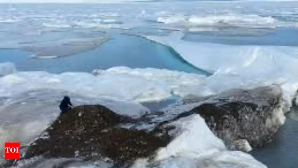
- The event originated from a large landslide in Dickson Fjord, Greenland.
- A significant collapse of Hvide Stovhorn peak led to a rock-ice avalanche, triggering a submarine landslide.
Additional Details
- Seiche Effect: In the confined fjord, waves bounce between its walls, creating a phenomenon known as a “seiche.” This back-and-forth sloshing continued for over nine days, with waves oscillating every 90 seconds.
- The earthquake resulted in a 200-metre-high mega-tsunami in a remote area of the Arctic Ocean, which, while not causing any casualties, damaged an unstaffed research facility on the island of Ella.
- The seismic signals from the seiche waves reverberated globally, causing vibrations detectable on seismometers as far as Antarctica.
- Link to Climate Change: The landslide was facilitated by the melting and retreating glacier at the fjord's foot, a direct consequence of global warming. This left the rocky slope unsupported, leading to its collapse and highlighting the detrimental impacts of climate change in polar regions.
In summary, this event serves as a critical reminder of the ongoing effects of climate change, particularly in sensitive polar environments, and the complex interactions between geological phenomena and environmental changes.
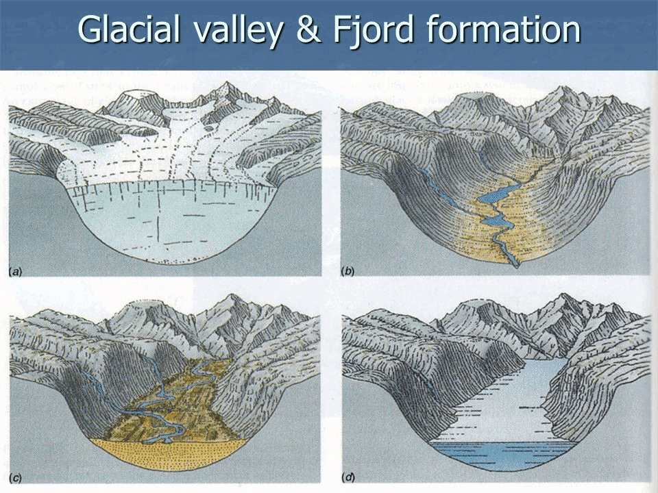
What are Fjords?
Fjords are elongated, deep, narrow steep-sided inlets of the sea that extend far inland, formed by the inundation of glaciated valleys. They are typically located in mountainous areas of both the Northern and Southern Hemispheres, particularly in higher latitudes (up to about 80°).
Formation of Fjords
- Fjords were created during the last Ice Age as glaciers slowly carved out deep valleys.
- The force of the deepest inland glaciers was most intense during glaciation.
Geographic Distribution of Fjords
- Fjords are predominantly found in countries such as Norway, Chile, New Zealand, Canada, Greenland, and Alaska.
Coral Reefs in Fjords
- Some fjords host deep cold-water coral reefs that support various marine species like fish, plankton, and sea anemones.
- These cold-water reefs thrive in complete darkness and under extreme pressure, contrasting sharply with tropical reefs.
Skerries (Rocky Islands)
- Skerries are small rocky islands formed by glaciation, commonly found around fjords.
- They are prevalent along the Scandinavian coastline.
Fjords as Calm Harbours
- Despite rocky islands or skerries that may complicate navigation, fjords generally offer calm and sheltered waters.
- This characteristic makes them ideal harbours for ships seeking tranquil anchorage.
Poleward Shift of Atmospheric Rivers
 Why in News?
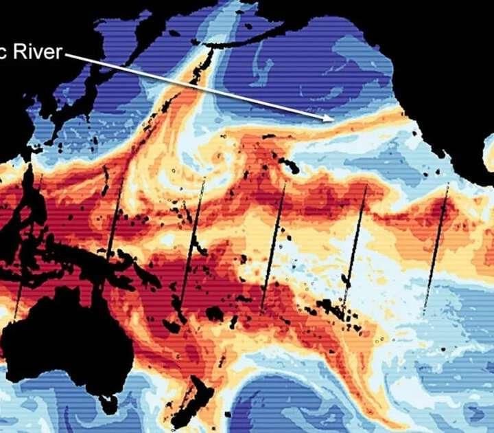
A recent study has indicated that atmospheric rivers (ARs) have shifted poleward by 6 to 10 degrees over the past 40 years, which has significant implications for global weather patterns.
This shift has resulted in:
- Increased droughts in certain regions.
- Intensified floods in others.
- Major impacts on water resources and climate stability.
Key Takeaways
- Sea Surface Temperature Changes: A cooling of sea surface temperatures in the eastern tropical Pacific since 2000, linked to La Niña conditions, is causing ARs to shift poleward.
- Walker Circulation: Strengthening of the Walker circulation in the western Pacific expands the tropical rainfall belt, altering atmospheric patterns and directing ARs toward the poles.
- Long-term Climate Trends: The IPCC reports a global temperature increase of approximately 1.1°C since the pre-industrial era, which has altered jet stream patterns and impacted weather events.
Additional Details
- Implications for Water Resource Management: Regions like California and southern Brazil may face prolonged droughts and water shortages due to decreased frequency of ARs.
- Increased Flooding and Landslides: Areas at higher latitudes, such as the US Pacific Northwest and Europe, may experience more extreme rainfall and flooding risks.
- Arctic Climate Impact: The shift of ARs into the Arctic has contributed to sea ice melting, accounting for 36% of the summer moisture increase in the Arctic since 1979.
- Predictive Challenges: The variability of natural processes complicates predictions of future AR behavior, potentially leading to miscalculations in weather forecasting.
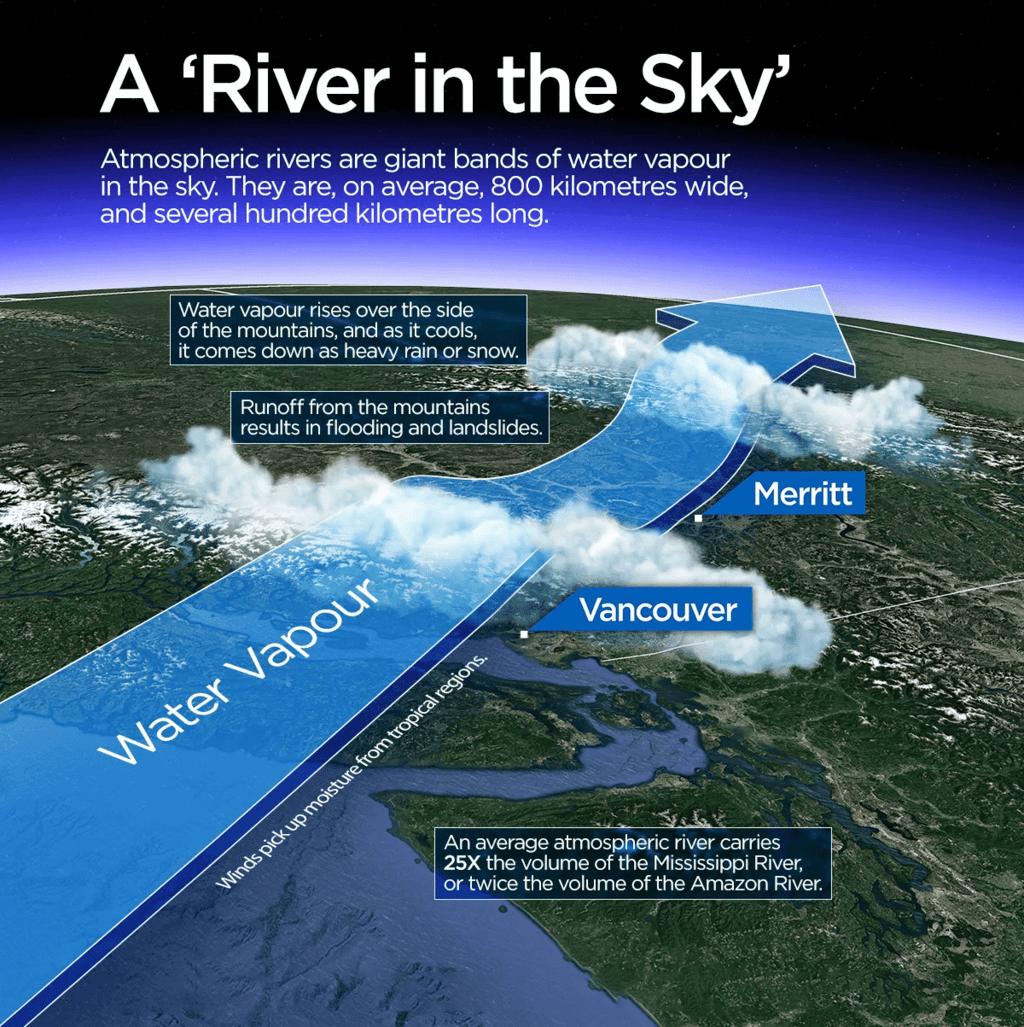
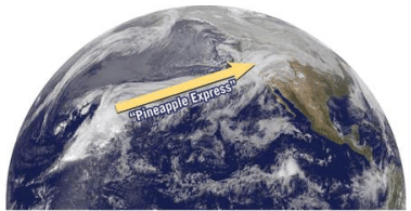
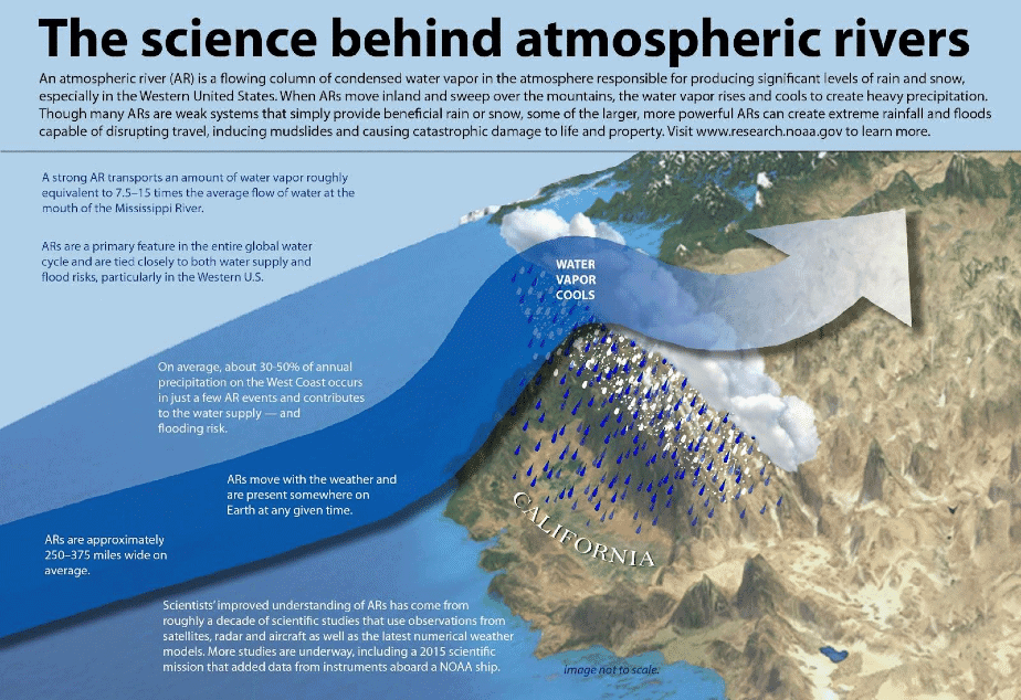
Atmospheric rivers (ARs) are long, narrow bands of moisture that transport significant amounts of water vapor from tropical regions to mid-latitudes. For example, the 'Pineapple Express' transports warm, humid air from the tropical Pacific near Hawaii to the west coast of North America, especially California.
Conditions required for the formation of ARs include:
- Strong Low-Level Winds: These winds act as pathways for water vapor transport.
- High Moisture Levels: Essential for initiating precipitation processes.
- Orographic Lift: Moist air masses rise and cool over elevated terrains, leading to precipitation.
Categories of Atmospheric Rivers
- Category 1 (Weak): Mild events with light rainfall.
- Category 2 (Moderate): Moderate storms that are mostly beneficial but potentially hazardous.
- Category 3 (Strong): Prolonged events bringing significant rainfall, which can help reservoirs but may raise rivers near flood stage.
- Category 4 (Extreme): Hazardous events bringing intense rainfall over several days.
- Category 5 (Exceptional): Extremely hazardous with serious impacts, such as significant damages exceeding USD 100 billion.
Key Characteristics of Atmospheric Rivers
- Length: Can extend for thousands of kilometers, similar to terrestrial rivers.
- Seasonal Occurrence: Typically occur between December and February in the Northern Hemisphere and June to August in the Southern Hemisphere.
- Water Vapour Capacity: An average AR can carry water vapor equivalent to the flow at the mouth of the Mississippi River.
- Variability: Each AR has unique characteristics influenced by atmospheric conditions.
Role of Atmospheric Rivers
Positive Role:
- Redistribution of Freshwater: ARs contribute over 50% of annual runoff in many regions, such as California.
- Global Water Cycle: Crucial for influencing water supply and flood risks, especially in the western United States.
- Snowpack Formation: ARs deposit snow, which melts to maintain water levels during warmer months.
Negative Role:
- Flooding: Excess precipitation can lead to soil saturation and flooding.
- Landslides and Mudslides: Increased rain on steep terrains raises the risk of these events.
- Droughts: A lack of ARs can lead to prolonged droughts and water scarcity.
The poleward shift of atmospheric rivers, driven by climate change, is causing significant disruptions in global weather patterns. Regions at higher latitudes are experiencing increased precipitation and flooding, while lower latitudes may face severe droughts. To mitigate these impacts, it is essential to enhance weather forecasting, invest in water infrastructure, and reduce greenhouse gas emissions.
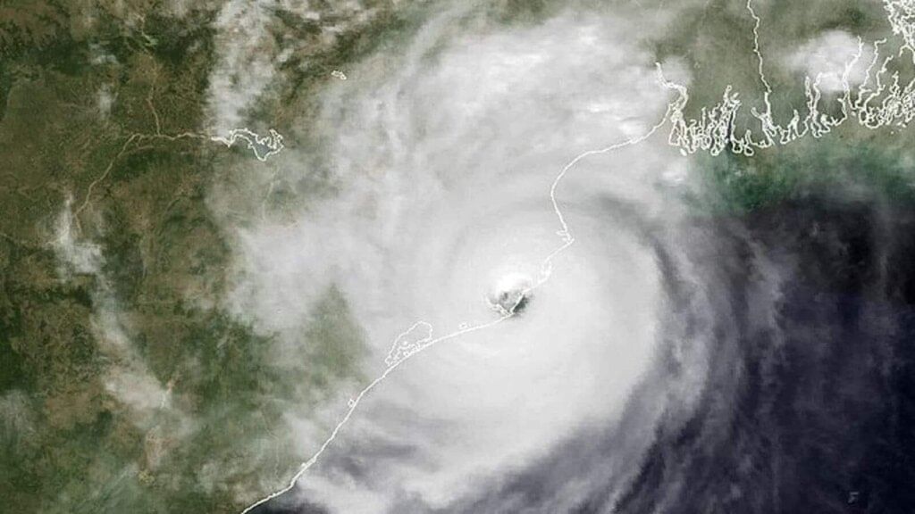
Cyclone Dana
 Why in News?
According to the India Meteorological Department (IMD), Cyclone Dana is expected to make landfall as a severe cyclone (with wind speeds of 89 to 117 km/h) along the Odisha coast near Bhitarkanika National Park and Dhamra Port.
Key Takeaways
- Cyclone Dana is the third cyclone to form in the North Indian Ocean region and the second in 2024 following Cyclone Remal.
- This cyclone marks the first occurrence in the post-monsoon season.
Additional Details
- Naming of Dana: The World Meteorological Organisation (WMO) states that Cyclone Dana was named by Qatar. In Arabic, 'Dana' signifies 'generosity' and refers to 'the most perfectly sized, valuable, and beautiful pearl.'
- Reasons for Intense Rainfall:
- Intense Convection: The cyclone exhibits intense convection in its western sector, extending to the upper layers of the atmosphere.
- Warm Moist Air: An influx of warm, moist air into the cyclone's core enhances convection and leads to more intense rainfall.
- Madden Julian Oscillation (MJO) Influence: The MJO is currently supportive of convection, leading to heavy rainfall during its enhanced phase.
Factors Responsible for Tropical Cyclone Formation
- Warm Ocean Waters: Sea surface temperatures of at least 27°C are crucial for the development of tropical cyclones.
- Coriolis Force: The Coriolis effect, caused by Earth's rotation, is necessary for giving the cyclone its spin, typically forming at least 5° north or south of the equator.
- Low Wind Shear: Low vertical wind shear is essential; high wind shear can disrupt the storm's structure.
- Pre-existing Disturbance: Initial disturbances, such as low-pressure systems, provide the necessary organization for cyclone formation.
- Convergence of Air: The convergence of warm, moist air at the surface is fundamental to developing the cyclone's core.
Impacts of Cyclone
- Human Impact: Cyclones can lead to widespread casualties due to strong winds, storm surges, and flooding, displacing thousands.
- Infrastructure Loss: Strong winds can cause power outages and structural damage, while flooding disrupts transportation and communication.
- Environmental Impact: High winds and storm surges erode coastlines and destroy natural habitats.
- Agricultural Loss: Low-lying agricultural areas are vulnerable to seawater intrusion and waterlogging, affecting productivity.
Measures for Effective Cyclone Disaster Preparedness and Mitigation
- Before Cyclone:
- Land Use Planning: Implement building codes to restrict habitation in vulnerable zones.
- Cyclone Early Warning System: Utilize an impact-based cyclone warning system to communicate risks effectively.
- Engineered Structures: Construct buildings designed to withstand cyclone winds.
- Mangrove Plantation: Promote mangrove planting to shield coastal areas from storm surges.
- During Cyclone:
- Cyclone Shelters: Establish shelters in high-risk areas for emergency access.
- Flood Management: Implement sea walls and drainage systems to control water flow and reduce flooding.
- After Cyclone:
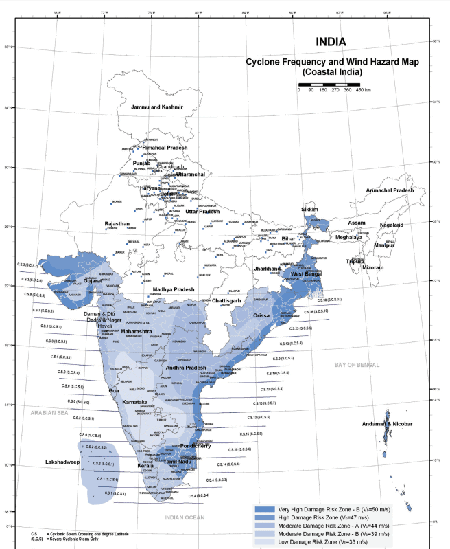
- Hazard Mapping: Create maps indicating cyclone frequency and intensity based on historical data.
- Retrofitting Non-Engineered Structures: Educate communities on retrofitting techniques to enhance resilience.
In conclusion, proactive disaster management measures are essential. Implementing effective early warning systems, land use planning, and community involvement can enhance infrastructure resilience and better prepare vulnerable coastal regions for cyclone impacts.
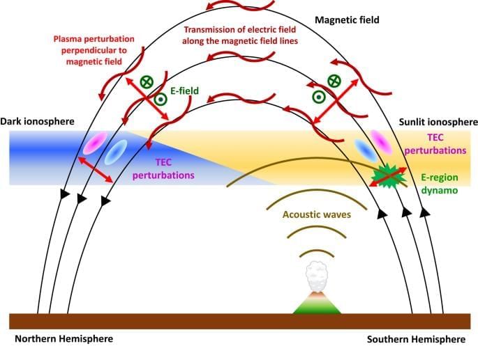
Volcanic Eruption and Ionospheric Disturbances
 Why in News?
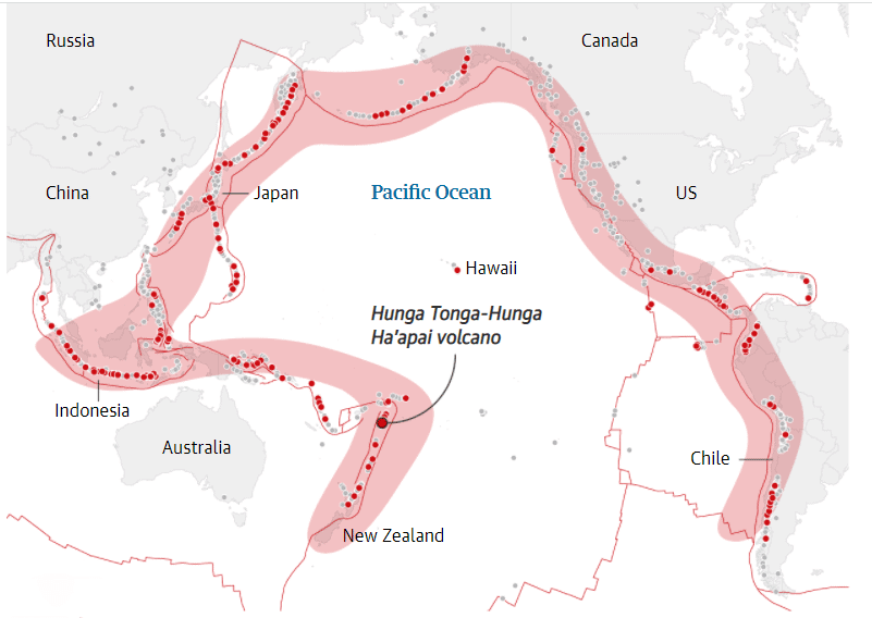
A recent study has highlighted a significant link between the eruption of the Tonga volcano and the emergence of Equatorial Plasma Bubbles (EPBs) over the Indian subcontinent. The Tonga volcano is categorized as a submarine volcano situated in the South Pacific Ocean.
Key Takeaways
- The Tonga eruption initiated ionospheric disturbances, which are crucial for understanding space weather events that impact satellite communications.
- Strong atmospheric gravity waves generated by the eruption propagated to the upper atmosphere, creating favorable conditions for EPB formation.
- Detection of plasma instabilities indicated heightened ionospheric disturbances related to the eruption.
Additional Details
- Atmospheric Gravity Waves: These waves occur when buoyancy forces lift air upward, while gravitational forces pull it back down, resulting in disturbances that can influence the ionosphere.
- Equatorial Plasma Bubbles (EPBs): EPBs are regions in the ionosphere characterized by depleted plasma, forming near the magnetic equator during post-sunset hours. They can extend to 15° North and South of the equator, affecting global ionospheric conditions.
- EPBs can disrupt radio wave propagation, leading to signal degradation, which poses a significant challenge for communication systems that depend on high-frequency signals, including satellite communications and GPS.
- These phenomena are most prevalent around the Winter solstice (December 21 or 22) and least frequent during the Summer solstice (June).
Key Facts About the Tonga Volcano
- Location: The Tonga volcano is found in the western South Pacific Ocean, situated west of the major inhabited islands of Tonga.
- Geology: It is one of twelve confirmed submarine volcanoes along the Tofua Arc, part of the larger Tonga-Kermadec volcanic arc, formed by the subduction of the Pacific Plate beneath the Indo-Australian Plate. This region is also known as the Ring of Fire.
- Submarine Volcano: The Tonga volcano comprises two small uninhabited islands, Hunga-Ha’apai and Hunga-Tonga.
Understanding the relationship between volcanic eruptions and ionospheric disturbances is crucial for predicting space weather events and mitigating their impact on communication systems.
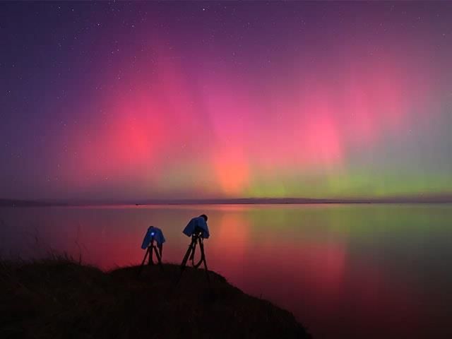
Aurorae in Ladakh
 Why in News?
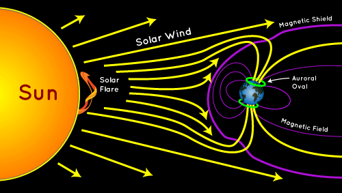
Recently, auroras have been spotted in lower-latitude regions, including places like India (specifically Hanle and Merak in Ladakh), as well as in Mexico and Germany. This unusual occurrence at lower latitudes indicates increased solar activity.
Key Takeaways
- Auroras are visible when coronal mass ejections (CMEs) interact with Earth's magnetosphere.
- The current solar cycle, known as Solar Cycle 25, is peaking in 2024.
- A severe solar storm, rated level 4 on a scale of 1 to 5, has caused aurora sightings in these regions.
Additional Details
- Aurora: An aurora is a stunning natural light display seen in the night sky, often showcasing a variety of colors such as blue, red, yellow, green, and orange. The green-yellow hues are most common and occur when ions collide with oxygen atoms at lower altitudes.
- Reddish and bluish lights at the lower edges of auroras are produced by interactions with nitrogen atoms. Rare blue and purple auroras can occur through collisions with hydrogen and helium atoms, but these colors are not typically visible to the naked eye.
- Geographical Occurrence: Auroras are predominantly observed near the Arctic and Antarctic Circles, approximately 66.5 degrees north and south of the Equator. The phenomenon is referred to as the aurora borealis (northern lights) in the north, while the southern counterpart is called aurora australis (southern lights).
- Cause of Auroras: Auroras are generated when charged particles from solar storms interact with the Earth’s magnetosphere, which shields us from harmful solar and cosmic rays. Solar storms result from fluctuations in the Sun's magnetic field, allowing charged particles to breach the Earth's magnetic defenses.
- Role of Solar Wind and Earth's Magnetosphere: Auroras occur when charged ions from the solar wind collide with oxygen and nitrogen atoms in the Earth's ionosphere, typically at altitudes between 97 and 1,000 kilometers. Most solar wind particles are deflected by the Earth's magnetosphere, but some become trapped near the geomagnetic poles, leading to these spectacular light displays.
Nasa's IMAGE satellite, which was operational until 2005, was specifically designed to study auroras. It collected vital data on the formation and behavior of auroras using ultraviolet and radio waves. Additionally, planets that possess an atmosphere and magnetic field, such as Jupiter and Saturn, are also known to experience auroras.
|
63 videos|5408 docs|1146 tests
|
FAQs on Geography - 2 - Current Affairs & Hindu Analysis: Daily, Weekly & Monthly - UPSC
| 1. What is the significance of latitudinal variation in the Sun's rotation speed? |  |
| 2. How can a landslide induce an earthquake, particularly in regions like Greenland? | |
| 3. What are atmospheric rivers and how are they shifting poleward? | |
| 4. What impact did Cyclone Dana have on the areas it affected? | |
| 5. How do volcanic eruptions lead to disturbances in the ionosphere? | |


shortcuts and tricks
,Sample Paper
,MCQs
,Geography - 2 | Current Affairs & Hindu Analysis: Daily
,study material
,Exam
,Extra Questions
,past year papers
,Geography - 2 | Current Affairs & Hindu Analysis: Daily
,Summary
,Free
,Weekly & Monthly - UPSC
,Geography - 2 | Current Affairs & Hindu Analysis: Daily
,Viva Questions
,Semester Notes
,Objective type Questions
,Weekly & Monthly - UPSC
,Previous Year Questions with Solutions
,Weekly & Monthly - UPSC
,ppt
,mock tests for examination
,video lectures
,practice quizzes
,Important questions
;


Geography - 2 Free PDF Download
Importance of Geography - 2
Geography - 2 Notes
Geography - 2 UPSC Questions
Study Geography - 2 on the App
|
© EduRev
|
Education Revolution
|


|


within 7 days!