Geography - 3 | Current Affairs & Hindu Analysis: Daily, Weekly & Monthly - UPSC PDF Download
| Table of contents |
|
| Ken-Betwa Link Project |
|
| Hydrothermal Vents in Indian Ocean |
|
| Ocean Anoxic Event 1a (OAE 1a) |
|
| Key Facts about Golan Heights |
|
| 2024 Arctic Report Card |
|
| Human Evolution and Migration |
|

Ken-Betwa Link Project
 Why in News?
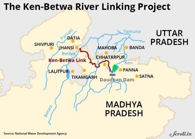
Recently, Prime Minister Narendra Modi laid the foundation stone for the Ken-Betwa Link Project (KBLP) in Khajuraho, Madhya Pradesh. This Rs 45,000 crore initiative, part of the National Perspective Plan (NPP) for interlinking rivers, aims to resolve water scarcity in Bundelkhand.
Key Takeaways
- The KBLP is India's first initiative under the NPP, formulated in 1980 for river interlinking, implemented by the Ken-Betwa Link Project Authority.
- The project aims to transfer surplus water from the Ken River in Madhya Pradesh to the Betwa River in Uttar Pradesh, both tributaries of the Yamuna.
Additional Details
- Phases of the Project:
- Phase I: Construction of the Daudhan Dam complex, low-level and high-level tunnels, Ken-Betwa link canal, and powerhouses.
- Phase II: Development of the Lower Orr Dam across the Orr River (a tributary of the Betwa), Bina Complex Project, and Kotha Barrage.
- Benefits:
- Irrigation for 6.3 lakh hectares annually.
- Drinking water supply for 62 lakh people.
- Includes provisions for hydropower generation (100 Megawatt (MW)) and solar energy (27 MW).
- Importance for Bundelkhand:
Bundelkhand is a geographical region spanning 13 districts in Uttar Pradesh and Madhya Pradesh, which has long faced droughts and water shortages. The KBLP aims to enhance drinking water access, boost agriculture with reliable irrigation, and foster regional development to reduce migration pressures.
- Environmental Concerns:
Critics have raised concerns about the project's environmental impact, especially on the Panna Tiger Reserve, which could see over 10% of its core area submerged. There are fears of significant loss of wildlife habitats, including those of tigers and other species, as well as the felling of over 23 lakh trees.
- Government Response:
The government has assured that the construction will consider the preservation of wildlife in the Panna Tiger Reserve and implement measures to mitigate adverse effects on the local ecosystem, balancing development and conservation.

What is the National Perspective Plan (NPP) for Interlinking Rivers?
Formulated in 1980 by the Ministry of Irrigation (now Ministry of Jal Shakti), the NPP aims to develop water resources through the inter-basin transfer of water. The National Water Development Agency (NWDA) has been entrusted with the work of Interlinking Rivers under the NPP.
Components
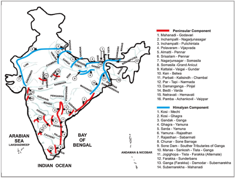
- The plan has two main components: the Himalayan Rivers and Peninsular Rivers Development.
- 30 link projects: 16 under the Peninsular Component, 14 under the Himalayan Component.
Peninsular Rivers Development Component
- Focuses on linking rivers in southern and central India. Key projects include the Mahanadi-Godavari, Godavari-Krishna, and Ken-Betwa links.
Himalayan Rivers Development Component
- Aims to divert surplus water from eastern tributaries of the Ganga and Brahmaputra to western regions. Notable projects include the Kosi-Ghaghra and Gandak-Ganga links.
Significance
- Addresses water shortages in states like Rajasthan, Gujarat, Andhra Pradesh, Karnataka, and Tamil Nadu.
- Improves irrigation, boosts agricultural productivity, and enhances food security.
- Promotes inland waterways for freight movement, utilizing surface water to alleviate groundwater depletion and reduce freshwater flowing into the sea.
Hydrothermal Vents in Indian Ocean
 Why in News?
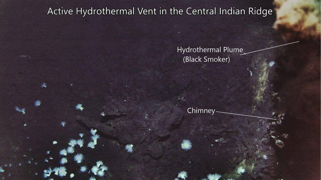
India's Deep Ocean Mission has recently marked a significant achievement by successfully imaging an active hydrothermal vent located 4,500 meters beneath the Indian Ocean's surface. This milestone not only enhances India's capabilities in mineral exploration but also contributes to deep-sea research, providing substantial prospects for the Samudrayaan mission and future exploration initiatives.
Key Takeaways
- Discovery of an active hydrothermal vent at a depth of 4,500 meters.
- Enhancement of India's mineral exploration and deep-sea research capabilities.
- Significant implications for the Samudrayaan mission.
Additional Details
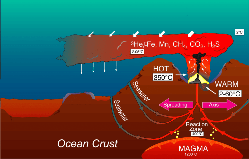
- Hydrothermal Vents: These are underwater hot springs situated near tectonic plates, where hot water and minerals are expelled from beneath the Earth's crust into the ocean. The first hydrothermal vents were discovered in 1977 near the Galapagos Islands, Ecuador.
- Formation Process: Seawater seeps through fissures in the ocean crust near tectonic plate boundaries, where it heats up to high temperatures (around 370°C) upon contact with magma, subsequently re-emerging as hydrothermal fluids.
- Types of Hydrothermal Vents:
- Black Smokers: Emit particle-laden fluids, primarily consisting of iron sulfides, forming black chimney-like structures.
- White Smokers: Emit fluids rich in barium, calcium, and silicon, creating white chimney formations.
- Significance: Hydrothermal vents are rich in valuable minerals such as copper, zinc, gold, silver, and platinum, and they support unique ecosystems where chemosynthetic organisms thrive, relying on chemicals for energy rather than sunlight.
- These vents can remain active for thousands of years (up to 30,000 years), allowing for ongoing exploration and resource utilization.
This breakthrough in imaging hydrothermal vents not only contributes to scientific knowledge but also opens avenues for potential resource extraction and ecological studies in the Indian Ocean.
Ocean Anoxic Event 1a (OAE 1a)
 Why in News?
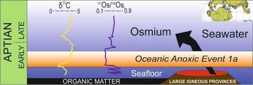
A recent study published in Science Advances has refined the timing and duration of Ocean Anoxic Event 1a (OAE 1a) by analyzing prehistoric rocks and fossils from Mount Ashibetsu, Japan. This event provides critical insights into past marine conditions and their implications for current environmental changes.
Key Takeaways
- Occurrence: OAE 1a took place during the Cretaceous Period (145–66 million years ago), characterized by depleted oxygen levels in Earth's oceans.
- Causes: Triggered by massive volcanic eruptions, leading to significant carbon dioxide (CO₂) emissions, global warming, and oxygen depletion in marine environments.
- Impacts: Resulted in the extinction of various marine species, particularly plankton, and contributed to the formation of black shales, which are organic carbon-rich layers preserved in geological records.
Additional Details
- Anoxic Marine Basins: These are bodies of water, often found in deep ocean regions, where oxygen levels are extremely low or absent. They promote the survival of specialized microbes while inhibiting most aerobic life forms.
- Carbon Sequestration: Low oxygen levels slow down the decomposition of organic matter, aiding in long-term carbon sequestration, which helps reduce atmospheric CO₂ levels. Examples include the Black Sea, Cariaco Basin, and Orca Basin.
- Recent Study Insights: The study established that OAE 1a began approximately 119.5 million years ago and lasted about 1.1 million years, indicating a prolonged recovery for oceans after CO₂-driven warming.
- Modern Relevance: The findings highlight parallels between ancient volcanic CO₂ emissions and current human-induced warming, suggesting that rapid modern warming could trigger similar ecological disruptions.
In summary, the Ocean Anoxic Event 1a serves as a crucial historical example of the effects of significant volcanic activity on marine ecosystems and underscores the potential consequences of contemporary climate change.
Key Facts about Golan Heights
 Why in News?
Israel has recently made a significant decision to double its population in the occupied Golan Heights, which has implications for both regional stability and international relations.
Key Takeaways
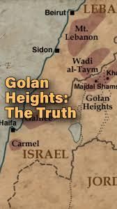
- The Golan Heights is a hilly region that has been under Israeli occupation since 1967.
- This area, historically part of Syria, is strategically important due to its location and resources.
- It is home to both Israeli settlers and a significant number of Syrian Druze Arabs.
Additional Details
- Geographical Location: The Golan Heights overlooks the upper Jordan River valley and is bordered by the Sea of Galilee to the west, Mount Hermon to the north, and the Yarmouk River to the south. Its dimensions are approximately 71 km north to south and 43 km east to west, covering an area of about 1,150 square kilometers.
- Historical Context: The region was part of Syria until it was occupied by Israel during the 1967 Six-Day War, with most Syrian inhabitants fleeing. An armistice was signed in 1974, and despite international law designating it as occupied territory, Israel maintains control and has established over 30 settlements there.
- Strategic Importance: The Golan Heights provides a vantage point over northern Israel and is crucial for water resources, as rainwater from this area feeds into the Jordan River.
The situation in the Golan Heights remains a focal point of geopolitical tension, with ongoing disputes over territory and governance. Understanding its significance is essential for comprehending broader Middle Eastern dynamics.
 min read
2024 Arctic Report Card
 Why in News?
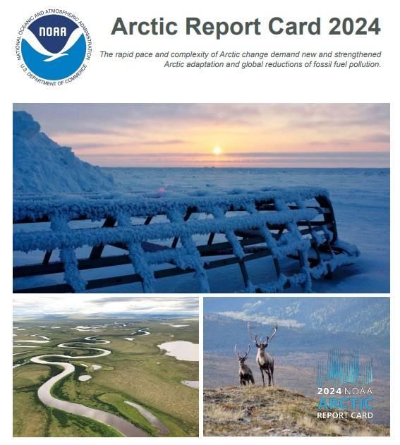
A recent report titled the 2024 Arctic Report Card, published by the National Oceanic and Atmospheric Administration (NOAA), highlights a significant shift in the Arctic's role in climate dynamics. Once a major carbon sink, the Arctic is now transitioning into a carbon source as a result of ongoing climate-induced warming.
Key Takeaways
- The Arctic is warming at an alarming rate, with 2024 being recorded as the second-warmest year since 1900.
- The summer of 2024 was noted as the third warmest on record, particularly affecting regions such as Alaska and Canada, which experienced intense heat waves.
Additional Details
- Accelerated Arctic Warming: The rapid warming has led to significant changes in the environment, including an increase in wildfires, which are becoming more frequent and intense, further contributing to carbon emissions.
- Arctic Tundra as a Carbon Source: Thawing permafrost is transitioning the Arctic tundra from a carbon sink to a carbon source, releasing carbon dioxide and methane into the atmosphere and exacerbating global warming.
- The reduction in the extent and thickness of sea ice has been observed over the past decades, resulting in more dark ocean surfaces that absorb heat, thus accelerating warming.
- Glaciers and the Greenland Ice Sheet continue to contribute to rising sea levels through increased meltwater.
The implications of these changes are significant as they contribute to global challenges such as coastal flooding, extreme weather events, and wildfires. The diminishing ability of the Arctic to store carbon emphasizes the urgent need to reduce greenhouse gas emissions to mitigate further risks. Additionally, the decline of reindeer or caribou populations due to climate change directly impacts Indigenous communities that rely on these animals for food and cultural practices.
What is the Arctic?
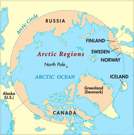
- About: The Arctic is the northernmost polar region of Earth, encompassing the Arctic Ocean, adjacent seas, and parts of Alaska (US), Canada, Finland, Greenland, Iceland, Norway, Russia, and Sweden. It is characterized by extremely cold temperatures, often dropping below freezing.
- Geopolitical Importance: The region is rich in natural resources such as oil, natural gas, and minerals, which has generated significant international interest and competition among nations for control over these resources.
India's Interest in the Arctic Region
- India has engaged with the Arctic by signing the Svalbard Treaty in 1920 and initiated its Arctic research program in 2007.
- The first scientific expedition to the Arctic Ocean was launched in 2008, establishing the Himadri research base in the Svalbard archipelago, Norway.
- India has held observer status in the Arctic Council since 2013, and in 2022, the Indian government announced an Arctic policy focused on climate research. The National Centre for Polar and Ocean Research will be the nodal agency for its implementation.
Human Evolution and Migration
 Why in News?
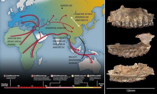
Recent scientific research has confirmed that Homo sapiens originated in Africa and subsequently migrated to different regions across the globe. However, the specific routes and timing of these migrations remain topics of ongoing debate among scientists.
Key Takeaways
- The out-of-Africa theory is widely accepted, but details regarding migration routes and timelines vary.
- The coastal dispersion theory proposes that early humans migrated along coastlines, which is still under scrutiny due to limited archaeological evidence.
Additional Details
- Coastal Dispersion Theory:
This theory suggests that early humans traveled along coastlines, taking advantage of warm climates and abundant food sources. Notable studies include:
- A 2005 study analyzing mitochondrial DNA from 260 Orang Asli individuals indicated rapid coastal migration around 65,000 years ago, reaching Australia via the Indian Ocean.
- A 2020 study on ancient DNA from Japan found genetic connections with Taiwanese tribes, supporting coastal migration theories.
- Settlements in the Andaman Islands are also thought to correlate with this coastal migration.
- Challenges to the Theory:
Contrary evidence exists, particularly in India, where archaeological findings indicate a predominance of inland sites with no substantial traces along the Indian Ocean coastline.
- Inland Dispersion Model:
This model posits that early humans migrated through interior routes. Key findings include:
- A study of Middle Palaeolithic tools in the Bhadar and Aji river basins of Gujarat revealed artifacts dated to 56,000–48,000 years ago, suggesting inland migration.
- These tools exhibited advanced flaking techniques, unlike the sharper blades of the Late Palaeolithic period.
- Research indicates that during the Middle Palaeolithic, Saurashtra was likely linked to regions such as Kutch and the Western Ghats, further distancing itself from the coastline.
- No evidence of dependence on marine resources was found, which further supports the inland migration hypothesis.
The ongoing studies provide new insights into human migration patterns, emphasizing the necessity for accurate dating. While current evidence challenges the notion of purely coastal migrations, it also underscores the complexity of human dispersal, which includes coastal, hinterland, and inland areas. This multifaceted approach highlights the importance of integrating genetic and archaeological findings as our understanding of human evolution and migration continues to develop.
|
38 videos|5283 docs|1116 tests
|
FAQs on Geography - 3 - Current Affairs & Hindu Analysis: Daily, Weekly & Monthly - UPSC
| 1. What are the main causes of aurorae in Ladakh? |  |
| 2. What is the Ken-Betwa Link Project and its significance? | |
| 3. What are hydrothermal vents and their importance in the Indian Ocean? | |
| 4. What was the Ocean Anoxic Event 1a (OAE 1a), and why is it significant? | |
| 5. What are the key facts about the Golan Heights? | |


MCQs
,past year papers
,Geography - 3 | Current Affairs & Hindu Analysis: Daily
,Free
,mock tests for examination
,video lectures
,shortcuts and tricks
,Objective type Questions
,Weekly & Monthly - UPSC
,Viva Questions
,practice quizzes
,Geography - 3 | Current Affairs & Hindu Analysis: Daily
,study material
,Summary
,Important questions
,Weekly & Monthly - UPSC
,ppt
,Sample Paper
,Geography - 3 | Current Affairs & Hindu Analysis: Daily
,Extra Questions
,Semester Notes
,Weekly & Monthly - UPSC
,Exam
,Previous Year Questions with Solutions
;


Geography - 3 Free PDF Download
Importance of Geography - 3
Geography - 3 Notes
Geography - 3 UPSC Questions
Study Geography - 3 on the App
|
© EduRev
|
Education Revolution
|


|


