Geography: July 2023 UPSC Current Affairs | Current Affairs & Hindu Analysis: Daily, Weekly & Monthly PDF Download
| Table of contents |

|
| Massive Shelf Clouds Formation |

|
| Anthropocene Epoch |

|
| Marine Heatwave and its Impacts |

|
| Lightning in India |

|
| Flash Floods in Himachal Pradesh |

|
Massive Shelf Clouds Formation
Why in News?
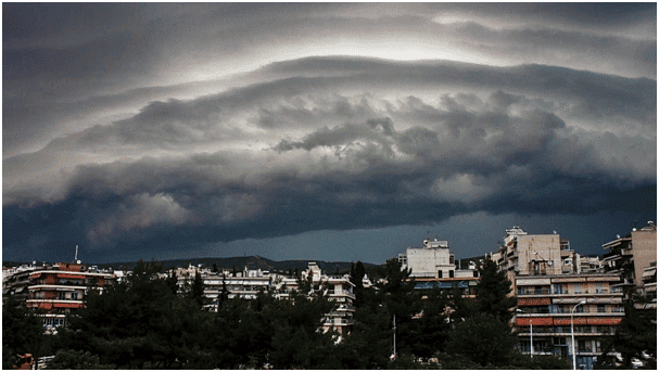
Recently, a massive Shelf Cloud formation has been spotted in Haridwar, Uttarakhand.
What are Shelf Clouds?
- About:
- Shelf clouds - also known as Arcus clouds - are often associated with powerful storm systems, and many times they are reported as wall clouds, funnel clouds, or rotation.
- These clouds are sometimes seen beneath cumulonimbus clouds, the dense, towering vertical cloud that causes intense rain.
- They often appear ahead of powerful Thunderstorms with heavy rain, strong winds, and occasionally hail or tornadoes.
- Formation:
- When a cold downdraft from a cumulonimbus cloud reaches the ground, the cold air may spread rapidly along the ground, pushing existing warm moist air upwards.
- As the cold air descends, it pushes warm air upward, causing condensation and cloud formation. This process creates the distinct horizontal shape and appearance of a shelf cloud.
What are the Types of Clouds?
- High Clouds:
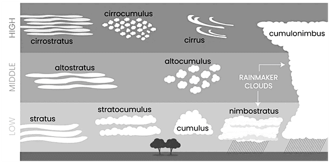
- Cirrus Clouds: Cirrus clouds are high-altitude clouds that appear wispy, feathery, and white. They are composed of ice crystals and are often associated with fair weather.
- Cirrus clouds can cause halo, a ring around the sun or the moon.
- Cirrocumulus Clouds: High-altitude clouds that appear as small, white, and fluffy cloud patches. They often have a wavy or honeycomb-like pattern.
- Cirrostratus Clouds: High-altitude clouds that form a thin, whitish veil covering the sky. They can produce halos around the sun or moon.
- Cirrus Clouds: Cirrus clouds are high-altitude clouds that appear wispy, feathery, and white. They are composed of ice crystals and are often associated with fair weather.
- Middle Clouds:
- Altocumulus Clouds: Mid-level clouds that form white or gray patches or layers. They often have a wavy or lumpy appearance.
- Altostratus Clouds: Mid-level clouds that create a uniform, gray or bluish-gray layer covering the sky. They are thicker and denser than cirrostratus clouds and can lead to light precipitation.
- Low Clouds:
- Cumulus Clouds: Cumulus clouds are fluffy, white clouds with a flat base and a rounded top. They are typically formed by rising warm air currents and are often seen on sunny days. Cumulus clouds can develop into cumulonimbus clouds, which are associated with thunderstorms.
- Stratus Clouds: Stratus clouds are low-level clouds that appear as a uniform grayish layer covering the sky. They often bring drizzle or light precipitation and can create a dull, overcast appearance.
- Stratocumulus Clouds: Low-level clouds with a patchy appearance, often appearing as rounded masses. They can be white or gray and cover a significant portion of the sky.
- Nimbostratus Clouds: Thick, dark, and featureless clouds that cover the sky. They bring continuous precipitation, often lasting for an extended period.
- Clouds that exhibit Significant Vertical Development:
- Cumulonimbus Clouds: Large, towering clouds associated with thunderstorms. They have a dark base and can reach high altitudes, producing heavy rain, lightning, and strong winds.

Anthropocene Epoch
Why in News?
Recently, the Anthropocene Working Group (AWG) has proposed that the Anthropocene, a new geological epoch characterized by significant human impact on Earth's systems, began in 1950.
- The AWG is an interdisciplinary research group dedicated to the investigation of the Anthropocene.
- If the proposal wins the necessary majority support, the International Union of Geological Sciences could officially ratify the new Global boundary Stratotype Section and Point (GSSP) in August 2024.
What is the Background?
- The starting date of Anthropocene is supported by evidence from Crawford Lake near Toronto, Canada, which contains traces of the radioactive element plutonium.
- Around the year 1950, there was a notable increase in the concentration of plutonium particles. This significant change serves as a clear indication of human impact and, consequently, provides evidence of the Anthropocene era.
- The research findings of Crawford Lake provided strong evidence for the AWG’s hypothesis that the unprecedented increase in industrial and socioeconomic activity of the Great Acceleration around the mid-twentieth century has caused alterations to the Earth System on a scale that terminated ~11,700 years of largely stable Holocene conditions and marks the beginning of a new Earth epoch.
What is the Anthropocene?
- The Anthropocene epoch as a term was first coined by Nobel Prize-winning chemist Paul Crutzen and biology professor Eugene Stoermer in 2000 to denote the present geological time interval, in which the Earth’s ecosystem has gone through radical changes due to human impact, especially since the onset of the Industrial Revolution.
- There are numerous phenomena associated with this epoch, such as Global Warming, Sea-Level Rise, Ocean Acidification, mass-scale soil erosion, the advent of deadly Heat Waves, deterioration of the biosphere and other detrimental changes in the environment.
What is the Holocene Epoch?
- The Holocene is the current geological epoch, which began approximately 11,700 years ago at the end of the last major ice age.
- It is characterized by a relatively stable and warm climate, as well as the development of human civilization.
- The Holocene follows the Pleistocene epoch and is part of the larger Quaternary period.
- During the Holocene, Earth's climate experienced fluctuations, but overall, it has been a period of relatively milder and more stable conditions compared to the preceding ice age. The retreat of glaciers and the rise in global temperatures allowed for the expansion of forests, grasslands, and diverse ecosystems.
What is the Geological Time Scale?
- Geologists divide the 4.6-billion-year existence of Earth into slices of time such as Eon, Era, System/Period, Series/Epoch, and Stage/Age.
- Eons are divided into Eras, Eras into Periods, Periods into Epochs, and Epochs into Ages.

- Each slice corresponds to significant happenings - such as the break-up of continents, dramatic shifts in climate, and even the emergence of particular types of animals and plant life.

Marine Heatwave and its Impacts
Why in News?
The northern Bay of Bengal has been experiencing an intense Marine Heatwave since 28th June 2023, leading to India’s usually arid northwest receiving extreme rainfall.
What is Marine Heatwave?
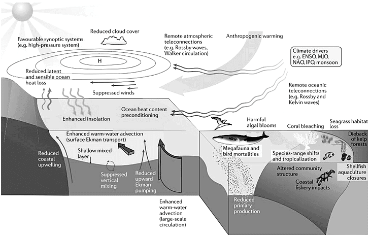
- Marine Heatwaves are prolonged periods of anomalously high Sea Surface Temperature (SST).
- These events are linked to coral bleaching, seagrass destruction, and loss of kelp forests, affecting the fisheries sector adversely.
- The most common drivers of marine heatwaves include ocean currents which can build up areas of warm water and air-sea heat flux or warming through the ocean surface from the atmosphere.
- Winds can enhance or suppress the warming in a marine heatwave, and climate modes like El Niño can change the likelihood of events occurring in certain regions.

How does Marine Heatwave Impact Rainfall in Northwest India?
- The marine heatwave in the Bay of Bengal increased sea surface temperatures, causing higher evaporation rates and a greater moisture supply in the atmosphere. This surplus of moisture contributed to above-average rainfall in northwest India.
- The marine heatwave likely influenced the formation and behavior of depressions in the Bay of Bengal, which may have contributed to an increase in the frequency and intensity of depressions, particularly on faster timescales (3-10 days).
- Depressions, which are low-pressure systems, play a significant role in the monsoon and rainfall patterns.
- The marine heatwave, along with changing timescales of depressions, affected the path and trajectory of these weather systems. Depressions tended to move more towards northwest India rather than north-central India, causing a higher concentration of rainfall in the northwest region, leading to above-average rainfall in that area.
What are the other Impacts of Marine Heatwaves?
- Affect Ecosystem Structure:
- Marine heat waves affect ecosystem structure, by supporting certain species and suppressing others.
- It has been associated with the mass mortality of marine invertebrates and may force species to change behaviour in a way that puts wildlife at increased risk of harm.
- Change Habitat Ranges of Certain Species:
- Marine heatwaves can change the habitat ranges of certain species, such as the spiny sea urchin off southeastern Australia which has been expanding southward into Tasmania at the expense of kelp forests which it feeds upon.
- Economic Losses:
- Marine heatwaves can cause economic losses through impacts on fisheries and aquaculture.
- Affect Biodiversity:
- Biodiversity can be drastically affected by marine heatwaves.
- A study from 2020 (Genesis and Trends in Marine Heatwaves Over the Tropical Indian Ocean and Their Interaction With the Indian Summer Monsoon) reveals that a previous marine heatwave led to bleaching of 85% of corals in the Gulf of Mannar near the Tamil Nadu coast.
- Increase the Risk of Deoxygenation and Acidification:
- Often, they occur alongside other stressors such as ocean acidification, deoxygenation, and overfishing.
- In such cases, MHWs not only further damage habitats, but also increase the risk of deoxygenation and acidification.
Lightning in India
Why in News?
Lightning has been a cause of concern in India, leading to a significant number of fatalities each year. As demands arise from states like Bihar and West Bengal to declare lightning a natural disaster, the Union government has taken a cautious stance.
- If approved, victims would be entitled to compensation from the State Disaster Response Fund (SDRF), of which 75% is contributed by the Central government.
What is the Current Scenario of Lightening in India?
- About:
- Lightning is a powerful and visible electrical phenomenon that takes place when there is a buildup of electrical charges within clouds and between clouds and the ground.
- The discharge of this electrical energy results in a brilliant flash of light and a rapid expansion of air, creating the characteristic thunder that accompanies lightning.
- Cloud-to-ground (CG) lightning is dangerous because it can electrocute people due to its high electric voltage and current.
- India ranks among the five countries worldwide with an early warning system for lightning.
- The system provides forecasts ranging from five days to as close as three hours before the occurrence of lightning.
- Lightning Fatalities: Statistics and Trends
- National Crime Records Bureau (NCRB) Data: In 2021, lightning accounted for 2,880 deaths, comprising 40% of all accidental deaths caused by "forces of nature."
- The trend indicates an increase in lightning-related fatalities compared to other natural events.
- Geographical Distribution in India:
- Lightning frequency is highest in northeastern states and West Bengal, Sikkim, Jharkhand, Odisha, and Bihar.
- However, the number of lightning-related deaths is higher in central Indian states like Madhya Pradesh, Maharashtra, Chhattisgarh, and Odisha.
- Bihar is one of the most vulnerable states to lightning strikes, with a significant number of deaths reported annually.
- In 2023, till July 6, Bihar recorded 107 deaths due to lightning.
- Union Government's View About Lightning:
- The Union government opposes declaring lightning a natural disaster. The government believes that education and awareness can help prevent lightning-related deaths effectively.
What are the Possible Factors Behind the Increasing Trend of Lightning Strikes?
- Climate Change: Global warming and climate change could potentially influence atmospheric conditions, leading to an increase in thunderstorms and lightning activity.
- As the planet's temperature rises, there may be changes in the distribution of moisture, instability, and convective processes that could favor more frequent lightning occurrences.
- Kalbaisakhi is a localised thunderstorm occurrence that is accompanied by lightning, typically observed during the pre-monsoon season in the Indian subcontinent.
- Urbanization: The expansion of urban areas can create what is known as the "urban heat island effect."
- Cities tend to be warmer than surrounding rural areas due to increased human activity, energy consumption, and impervious surfaces.
- These localized heat islands may lead to the formation of more thunderstorms and, consequently, an increase in lightning strikes.
- Land Use Changes: Deforestation, changes in agricultural practices, and alterations of natural landscapes may disrupt local atmospheric conditions.
- Such changes might contribute to the development of thunderstorms and, consequently, more lightning.
- Pollution and Aerosols: Air pollution, including aerosols and particulate matter, can affect cloud formation and electrical activity within storms.
- Anthropogenic emissions might influence the frequency and intensity of thunderstorms, potentially leading to more lightning strikes.
Way Forward
- Educational Campaigns: Launch extensive educational campaigns to raise awareness about lightning safety.
- The focus should be on educating people, especially in rural areas, about the dangers of lightning and the precautions they can take to stay safe.
- Lightning Prediction and Warning Systems: Develop and implement lightning prediction and warning systems to provide advanced notice of lightning storms. This can help people take necessary precautions and seek shelter in time.
- Lightning-Resistant Infrastructure: Encourage the construction of lightning-resistant infrastructure, especially in high-risk areas such as schools, hospitals, and public buildings.
- It can include installing lightning rods on tall structures, buildings, and houses to provide a safe path for lightning to travel to the ground, reducing the risk of damage from a direct strike.
- Also, using surge protectors for electrical equipment and devices. Lightning strikes can cause power surges that may damage sensitive electronics. Surge protectors can divert excess voltage and protect the equipment.
- Training for First Responders: Train local emergency services and first responders on how to deal with lightning-related incidents and provide them with necessary equipment.
Flash Floods in Himachal Pradesh
Why in news?
Flash floods were witnessed in Khotinallah near Aut (in HP) on the Pandoh–Kullu stretch due to a heavy downpour and the Chandigarh-Manali highway was blocked.
What are flash floods?
- Flash floods are sudden and rapid flooding events that happen within a short period of time.
- Flash floods are highly localised but causes high damages because of suddenness.
- This occurs in hilly regions and sloping lands where heavy rainfall and thunderstorms or cloudbursts are common.
- Low-lying areas, such as riverbeds, canyons, and urban areas with poor drainage systems are also prone to it.
How India is vulnerable to flash floods?
- In India, flash floods are often associated with cloudbursts.
- Himalayan states and the Western Ghats in Maharashtra and Kerala are more vulnerable to flash floods caused by cloud bursts.
- Himalayan states further face the challenge of overflowing glacial lakes, formed due to the melting of glaciers.
- Frequently, flash floods are accompanied by landslides.
- Other factors of flash floods includes sudden release of waters from upstream reservoirs, breaches in landslide dams, embankments on the banks of the rivers, depression and cyclonic storms
Reasons for flood | States |
Depression and cyclonic storms | coastal areas of Orissa, West Bengal, Andhra Pradesh, Karnataka, and Tamil Nadu |
Cloud bursts | Arunachal Pradesh, Assam, Orissa, Himachal Pradesh, Uttarakhand, the Western Ghats in Maharashtra and Kerala |
Breaches in embankments | Assam, Bihar, Uttar Pradesh, Orissa and Andhra Pradesh |
What are the reasons for frequent flood situations?
- According to the National Disaster Management Authority (NDMA), nearly 75% of the total Indian rainfall is concentrated over a short monsoon season of four months (June to September).
- Climate change - Rapid melting of glaciers in glacial lakes as an impact of global warming.
- Manmade reasons - Factors such as population growth, rapid urbanisation, increased developmental and economic activities in flood plains contribute to the increasing flood damage.
- Wildfires - Flash floods may be more frequent after wildfires in the future.
- Wildfires destroy forests and other vegetation, which in turn weakens the soil and makes it less permeable for water to seep through.
How dangerous are flash floods?
- Flash floods can occur without warning, catching people off guard and leaving little to no time for preparation and evacuation.
- Due to their speed and unpredictability, water levels can reach several feet in just a few minutes.
- They pose a significant threat to life, along with property and infrastructure.
- Flash floods accompanied by landslides further exacerbate the damage.
What are the mitigating measures?
- Comprehensive strategy of monitoring on the ground in hilly areas.
- Planning development works in a way that is sensitive to the region’s ecology and mitigation to reduce the extent of damages due to flash floods and landslides.
- Early warning systems, such as weather forecasts and monitoring of river levels are key to mitigating the risks associated with flash floods.
- Public education on flood preparedness and evacuation procedures.
|
63 videos|5408 docs|1146 tests
|


