Geography: July 2024 UPSC Current Affairs | Geography for UPSC CSE PDF Download
Aphelion

Why in news?
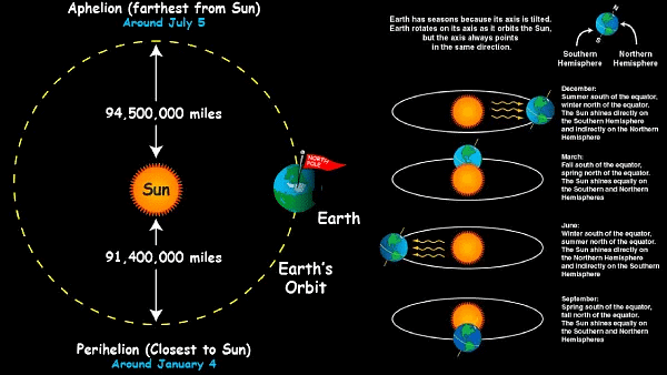
Recently, on 5th July 2024, Earth reached the farthest point in its elliptical orbit around the sun called aphelion.
What is Aphelion?
About
Aphelion refers to the point in Earth's orbit when it is farthest from the Sun, occurring around 3 to 6th July each year (According to NCERT, Aphelion is on 4 July).
The Earth's perihelion and aphelion dates are not fixed due to variations in its orbit eccentricity.
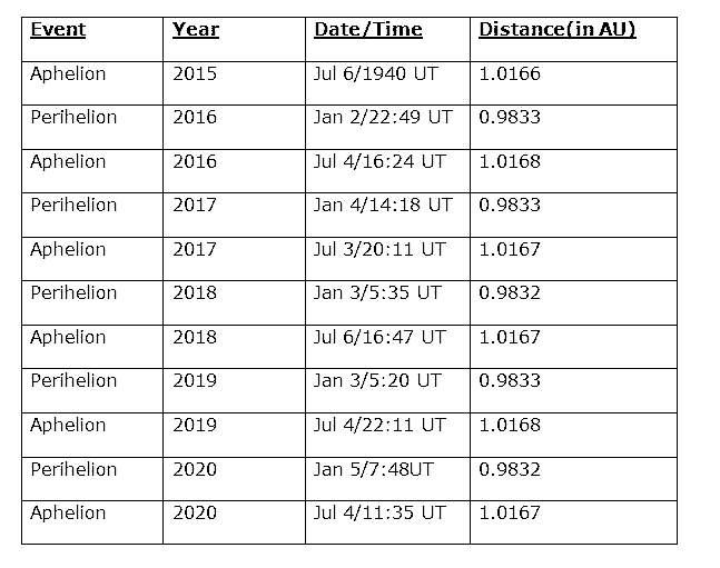
- At this juncture, the distance between Earth and the Sun extends to approximately 152.5 million kilometers.
- Perihelion: Earth is closest to the Sun, occurring around January 3 annually, with a distance of approximately 147.5 million kilometers.
- Significance of Aphelion:
- Variation in Solar Radiation: During early July, Earth's aphelion slightly reduces the sunlight reaching India, but this has a minor impact on temperatures. Seasonal changes, due to Earth's tilt, are much more important. The difference in solar radiation caused by Earth's elliptical orbit is only about 3%, showing that seasonal factors are the main influence on India's temperatures, even at aphelion.
- Stability of the Orbit: The aphelion is a natural consequence of Earth's elliptical orbit, which is a result of the gravitational interactions between the planets. Maintaining this slightly elliptical orbit is crucial for the long-term stability of the Earth's climate and habitability.
International Asteroid Day
Why in news?
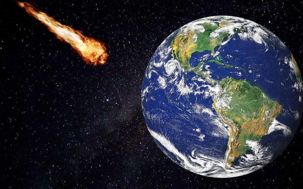
World Asteroid Day is observed on June 30 every year.
About World Asteroid Day:
- Observed to raise awareness about asteroid impact hazards and crisis communication actions in case of a credible asteroid threat to planet Earth.
- Aims to educate people about the latest and upcoming asteroid research and technology through numerous events and activities held by organizations across the globe.
History
- United Nations General Assembly (UNGA) passed a resolution in December 2016, designating June 30 as International Asteroid Day.
- The UNGA adopted the resolution based on the proposal made by the Association of Space Explorers endorsed by the Committee on the Peaceful Uses of Outer Space (COPUOS).
- The date was chosen to commemorate the anniversary of the Tunguska asteroid's impact over Siberia on June 30, 1908.
Tunguska Event:
- Considered the biggest asteroid impact in recorded history when an asteroid exploded a few kilometers above the Tunguska region of central Siberia.
- Flattened more than 80 million trees in seconds, over an area spanning nearly 800 square miles (2,000 square kilometers) but left no crater.
What is an Asteroid?
- Asteroids are small, rocky objects that orbit the sun.
- Although asteroids orbit the sun like planets, they are much smaller than planets.
- They are leftovers from the formation of our solar system.
- From being as small as 10 meters across to as huge as 530 km in diameter, asteroids have varied sizes.
New Study on Spiral Galaxies

Why in News?
Recently, a new study has shown that there were more spiral galaxies in the early universe than astronomers had previously anticipated.
What are the Key Highlights of the Research on Spiral Galaxies?
- Existing Theory: In astronomy, it's believed that as the universe cooled from a hot, dense state, it contained a lot of hot gas. This gas formed clumps that eventually came together to form galaxies. These early galaxies were irregular in shape and didn't have flat disks like we see in spiral galaxies today. Over billions of years, as these galaxies continued to cool down, they developed thick, hot disks that later flattened out into the spiral arms humans recognize now.
- Unexpected Early Formation: Contrary to the above theory, the new study suggests that spiral galaxies may have formed much earlier, around the same time as other types of galaxies were evolving. The study used data from NASA's James Webb Space Telescope to analyze 873 galaxies, identifying at least 216 as spiral galaxies. The research found that between 3 billion and 7 billion years after the Big Bang, the proportion of galaxies with spiral shapes increased significantly, from about 8% to 48%.
- Implications for Star Formation: The study's results could impact current understanding of star formation rates and the conditions necessary for earth-like planets to form within spiral galaxies. The presence of heavy elements in spiral arms, derived from supernovae, is crucial for planet formation.
What are the Various Types of Galaxies?
- Flattened Disk Galaxies: These galaxies have flattened disks with spiral arms, regions of active star formation, and a central bulge. Examples include the Milky Way and Andromeda Galaxy.
- Elliptical Galaxies: Elliptical galaxies have a smooth, oval, or round shape, little gas and dust, and are mostly composed of old stars. An example is the Messier 87 galaxy.
- Lenticular Galaxies: Lenticular galaxies are intermediate between spiral and elliptical galaxies. They have a disk but no arms. The Sombrero Galaxy is an example of a lenticular galaxy.
- Irregular Galaxies: Irregular galaxies have no regular shape and can be dwarf or large. The Large Magellanic Cloud is an example of an irregular galaxy.
- Active Galaxies: Active galaxies emit 100 times more light from the center than stars and are powered by supermassive black holes. Various subtypes include Seyfert Galaxies, Quasars, and Blazars with examples like Markarian 231 and TXS 0506+056.
Stromatolites

Why in news?
Scientists recently unearthed living stromatolites—ancient geological structures made from algae—on Sheybarah Island, nestled on the northeastern shelf of the Red Sea in Saudi Arabia.
- Stromatolites, or stromatoliths, are layered accretionary structures formed in shallow water by the trapping, binding, and cementation of sedimentary grains by biofilms of microorganisms, especially cyanobacteria (commonly known as blue-green algae).
- As sediment layered in shallow water, bacteria grew over it, binding the sedimentary particles and building layer upon millimeter layer until the layers became mounds.
- These structures are usually characterized by thin, alternating light and dark layers that may be flat, hummocky, or dome-shaped.
- Stromatolites were common in Precambrian time (i.e., more than 542 million years ago).
- Most stromatolites are marine but some forms from Proterozoic strata more than 2 ½ billion years old are interpreted as inhabiting intertidal areas and freshwater ponds lakes.
- Living stromatolites are found in only a few salty lagoons or bays on Earth.
- Western Australia is internationally significant for its variety of stromatolite sites both living and fossilized.
- Shark Bay in Western Australia one of only two places in the world where living marine stromatolites exist.
Importance
- Stromatolites provide some of the most ancient records of life on Earth by fossil remains which date back more than 3.5 billion years ago.
- Further, these biotic structures were instrumental in the Great Oxygenation Event two billion years ago, introducing oxygen into the atmosphere and transforming the planet's habitability.
- Being photosynthetic, cyanobacteria produce oxygen as a by-product. Photosynthesis is the only major source of free oxygen gas in the atmosphere.
- As stromatolites became more common 2.5 billion years ago, they gradually changed the Earth's atmosphere from a carbon dioxide rich mixture to the present-day oxygen-rich atmosphere. This major change paved the way for the next evolutionary step, the appearance of life based on the eukaryotic cell with a nucleus.
Kerala Migration Survey

Why in news?
The Kerala Migration Survey (KMS) 2023 report provides valuable insights into the shifting trends of migration from Kerala, highlighting significant changes and emerging patterns in emigration and return migration.
- The Kerala Migration Survey 2023 report, prepared by the International Institute of Migration and Development, and Gulati Institute of Finance and Taxation.
- The survey has been conducted every five years since 1998.
Details
International Institute of Migration and Development (IIMAD)
- Research centre in India focusing on studying international migration.
- Aims to become India's largest interdisciplinary research network on migration, collaborating with government and non-government organizations to address challenges faced by refugees, diasporic migrants, and migrant workers.
- Creates a platform for debate, research, policy analysis, and community engagement on global, national, and local scales.
- Focuses on cutting-edge academic scholarship, disseminating knowledge through publications, data banks, and conferences, promoting intellectual exploration for the betterment of migrants.
Key Findings of the Survey
- Total Emigrants and Returnees
- Number of emigrants from Kerala estimated at 2.2 million in 2023, slightly up from 2.1 million in 2018.
- Significant increase in returnees, with 1.8 million individuals returning to Kerala in 2023, up from 1.2 million in 2018 due to job losses during the COVID-19 pandemic.
- Decline in Gulf Migration
- Emigration to Gulf Cooperation Council (GCC) countries has decreased, with preference shifting towards non-GCC destinations.
- GCC countries accounted for 93.8% of Kerala's emigrants in 1998, but this has decreased to 19.5% in 2023.
- Rising Student Emigration
- Increase in the number of students migrating abroad for education, doubling since 2018 to reach approximately 250,000.
- This group now constitutes 11.3% of total emigrants.
- Increased Women Emigration
- Women emigrants have seen a rise both in numbers and proportion, increasing from 15.8% in 2018 to 19.1% in 2023.
- A significant portion (71.5%) of women emigrants are graduates, compared to 34.7% of men.
Remittances
- Total remittances to Kerala surged to Rs 216,893 crores in 2023, marking a 154.9% increase from 2018.
- This translates to a per capita remittance of Rs 61,118, with substantial contributions towards housing renovation, loan repayments, education, and healthcare.
- Reasons for Return
- Primary reasons for return migration include job loss (18.4%), low wages (13.8%), poor working conditions (7.5%), and health issues (11.2%).
Policy Implications and Recommendations
- Educational Infrastructure
- Enhance Kerala's educational infrastructure to accommodate the growing trend of students migrating abroad, focusing on quality education and support systems to ensure safe migration pathways and discourage fraudulent practices by recruitment agencies.
- Skill Development
- Strengthen skills training programs for labour emigrants to enhance their employability and attractiveness to non-GCC countries, particularly in the West, leading to better job opportunities and higher wages.
- Returnee Rehabilitation
- Develop comprehensive rehabilitation and reintegration programs for returning migrants, including skills upgrading, job placement, and psychological support to ease their transition back into Kerala's workforce.
Monitoring and Regulation
- Regularly monitor and regulate language training centres and recruitment agencies to prevent exploitation and ensure transparency in the migration process.
- Promote 'Brain Gain'
- Implement policies that incentivize skilled migrants to return to Kerala after gaining experience abroad, fostering a 'brain gain' phenomenon that can contribute to local development and innovation.
Bayesian Convolutional Neural Network (BCNN)
 Why in news?
Hyderabad-based Indian National Centre for Ocean Information Services (INCOIS) has developed a cutting-edge tool known as the Bayesian Convolutional Neural Network (BCNN) to predict the onset of El Niño and La Niña phases of the El Niño Southern Oscillation (ENSO) up to 15 months in advance. According to a recent bulletin released on June 5, there is a high likelihood (70-90% probability) of La Niña conditions emerging from July to September and persisting until February 2025.
About Bayesian Convolutional Neural Network (BCNN)
- BCNN, a variant of the Convolutional Neural Network, integrates Artificial Intelligence (AI), deep learning, and machine learning (ML) to forecast the initiation of El Niño and La Niña phases, providing extended predictive capabilities up to 15 months.
Functionality of the Model
- The BCNN model aims to improve forecasts related to El Niño and La Niña occurrences by leveraging the correlation between these phases and gradual oceanic alterations alongside atmospheric interactions.
Operational Details
- The model utilizes the Niño3.4 index value to make predictions, which averages sea surface temperature anomalies in the central equatorial Pacific region from 5°N to 5°S and 170°W to 120°W.
Significance
- Early Warning System: By analyzing oceanic variations and their atmospheric impacts, the tool offers timely forecasts, aiding in preparedness and planning.
- Advancement in ENSO Prediction: The BCNN model represents a significant leap in ENSO prediction technology, facilitating better comprehension and readiness for climate variability linked to ocean-atmosphere interactions.
What is ENSO?
ENSO, the El Niño Southern Oscillation, involves temperature fluctuations in the central and eastern tropical Pacific Ocean, influencing the overlying atmosphere. It operates in irregular cycles lasting 2-7 years and manifests in three main phases: warm (El Niño), cool (La Niña), and neutral.
- Neutral Phase: During the neutral phase, the eastern Pacific near South America experiences cooler temperatures due to prevailing east-to-west winds displacing warmer waters towards Indonesia.
- El Niño Phase: El Niño is characterized by weakened wind systems that reduce the displacement of warm waters, resulting in warmer-than-usual conditions in the eastern Pacific.
- La Niña Phase: Conversely, La Niña involves strengthened wind systems intensifying the displacement of warm waters towards Indonesia, leading to cooler-than-normal conditions in the eastern Pacific.
- Impact on India – Monsoon Effects:
- El Niño often brings about a weak monsoon and heightened heat waves across India.
- La Niña typically results in a robust monsoon season in the region.
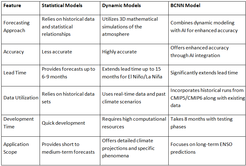
Comparison between Existing Models and BCNN Model
Challenges in Developing BCNN
- One challenge lies in the scarcity of oceanic data for training weather forecasting models, especially for long-term predictions like El Niño and La Niña.
- The availability of reliable global oceanic temperature records only dates back to 1871, resulting in a limited dataset for training deep learning models like BCNN.
Overcoming Data Challenges
- INCOIS tackled data scarcity by integrating historical runs from 1850-2014 from CMIP5 and CMIP6, enriching the model's predictive capacity for forecasting ENSO phases.
Maharashtra’s Water Crisis
Why in the news?
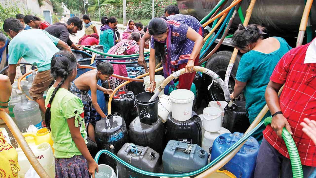
After last year’s deficient monsoon, the Maharashtra government declared several parts of the state as drought-hit.
Why do different regions of Maharashtra experience varied levels of water stress?
Geographical Differences: Coastal areas receive excessive rainfall leading to flooding. Marathwada lies in the rain-shadow region, receiving significantly less rainfall (600-800 mm) compared to the western side of the Western Ghats (2,000-4,000 mm).
Topography and Soil: Marathwada has clayey black soil (regur) which retains moisture but has a low infiltration rate, leading to poor groundwater recharge. The region’s topography, with parallel tributaries and gently sloping hills, results in uneven water distribution, with valleys having perennial groundwater and upland areas facing acute water scarcity.
Impact of Climate Change: Increasing drought severity and frequency in central Maharashtra due to climate change, worsening water stress in regions like Marathwada and North Karnataka.
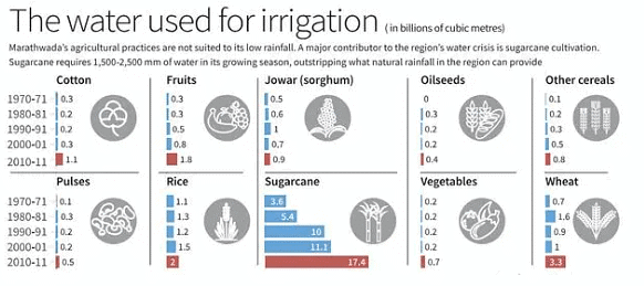
Why is sugarcane production not suited for regions with less rainfall?
- High Water Requirement: Sugarcane needs 1,500-2,500 mm of water during its growing season, which is much higher than the annual rainfall in low-rainfall areas like Marathwada.
- Irrigation Demands: Sugarcane requires almost daily irrigation, consuming 61% of the region’s irrigation water while occupying only 4% of the cropped area. This heavy water usage restricts the irrigation of other crops that are more suitable for the region’s climate, such as pulses and millet.
- Government Policies: Long-standing government support for sugarcane pricing and sales has encouraged its cultivation in unsuitable regions. The recent promotion of sugarcane-juice-based ethanol production exacerbates the issue, diverting water resources away from more sustainable agricultural practices.
What is meant by the rain-shadow effect?
- The rain-shadow effect occurs when moist winds from the Arabian Sea rise over the Western Ghats, causing heavy rainfall on the western side. By the time these winds descend on the eastern side (Western Maharashtra and Marathwada), they lose most of their moisture, resulting in significantly lower rainfall.
- Impact on Marathwada: Marathwada, located in the rain-shadow region, receives only 600-800 mm of annual rainfall, contributing to its dry climate and water scarcity issues.
- Note: Marathwada and North Karnataka have emerged as the second driest regions in India after Rajasthan.
How can supply-side solutions help the situation?
- Watershed Management: Building water-conserving structures such as contour trenches, earthen bunds, and gully plugs to capture and store runoff. Designing silt-trapping mechanisms to prevent soil erosion and maintain water retention structures.
- Rainwater Harvesting: Implementing measures to capture rainwater runoff from agricultural fields to recharge groundwater and reduce dependency on external water sources.
- Utilizing Government Programs: Leveraging funds from the Mahatma Gandhi National Rural Employment Guarantee Scheme (MGNREGS) for watershed management projects and training farmers in water conservation techniques.
- Promoting Water-Efficient Practices: Encouraging the use of water-efficient irrigation methods, such as drip irrigation, to optimize water usage. Shifting to drought-resistant crops and high-value, low-water-using crops to reduce water demand and improve agricultural sustainability.
- The state government has announced a massive Rs 59,000 crore package to transform the Marathwada region, with a focus on tackling the water crisis. This includes reviving stalled irrigation projects worth Rs 13,677 crore to make the region drought-free through water linking and diverting floodwaters to the Godavari basin
India Stands with the Philippines in the South China Sea

Why in news?
India's Ministry of External Affairs recently expressed firm support for the Philippines in defending its national sovereignty amidst tensions with China over the South China Sea. The diplomatic relations between the Philippines and India are approaching their 75th year in 2024. This milestone marks a transformative partnership between the two nations.
What is the Dispute in the South China Sea Region?
Significance of South China Sea
- Strategic Location: The South China Sea is strategically located, bordered by China and Taiwan to the north, the Indo-Chinese peninsula (including Vietnam, Thailand, Malaysia, and Singapore) to the west, Indonesia and Brunei to the south, and the Philippines to the east (referred to as the West Philippine Sea). Luzon Strait with the Philippine It is connected by the Taiwan Strait with the East China Sea and by Sea (both marginal seas of the Pacific Ocean)
- Trade Importance: One-third of all global shipping passes through the South China Sea. Over 64% of China's maritime trade passes through the South China Sea. Over 55% of India's trade passes through the South China Sea and Malacca Strait.
- Fishing Ground: The South China Sea is also a rich fishing ground, providing a vital source of livelihood and food security for millions of people in the region. It supports a diverse marine ecosystem and sustains fisheries contributing significantly to regional economies and food supplies.
- Dispute: The core of the South China Sea dispute involves competing claims over land features like islands and reefs and their surrounding waters. The involved parties in these disputes include China, Brunei, Taiwan, the Philippines, Vietnam, and Malaysia. Nine-dash line claim encompasses up to 90% of the sea, leading to tensions as it has expanded islands and built military installations to reinforce control.
What are the Areas of Cooperation Between India and the Philippines?
About:
- India and the Philippines formally established diplomatic relations in November 1949.
- With the Act East Policy initiated in 2014, the relationship with the Philippines has diversified further into political security; trade, industry, and people-to-people realms.
Bilateral Trade:
- As per the official trade figures of the Department of Commerce, Government of India, bilateral trade between India and the Philippines crossed the USD 3 billion mark for the first time in 2022-23.
- India exports engineering goods, automobile parts, petroleum products, pharmaceuticals, bovine meat, oilseeds, tobacco, and groundnuts to the Philippines.
- Imports from the Philippines to India include electrical machinery, semiconductors, ores, copper, plastics, pearls, waste from the food industry, and animal fodder.
Health and Medicine:
- The Philippines was the first ASEAN member to grant Emergency Use Authorization (EUA) for Bharat Biotech's Covaxin.
- Currently, the Philippines accounts for about 20% of India's pharmaceutical exports, with India being its largest supplier.
Science and Technology:
- A Bilateral Programme of Cooperation (POC) in Science and Technology was signed in October 2019, covering areas like agricultural biotechnology, material science, and ocean science.
- India signed a deal with the Philippines in January 2022 to supply a shore-based anti-ship variant of the BrahMos supersonic cruise missile.
Lipulekh Pass
Why in news?
Lipulekh Pass has been in the news as Indian traders involved in border trade with China through this pass have requested the central government to address the issue of resuming border trade via this route.
Overview:
- Indian traders conducting border trade with China through the Lipulekh pass have requested the Indian government to address the resumption of trade through this route.
About Lipulekh Pass:
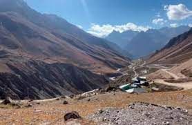
- Located in the Kumaon region of Uttarakhand, Lipulekh Pass is a high-altitude mountain pass near the trijunction of India, Nepal, and China.
- It serves as a link between Uttarakhand, India, and the Tibet region of China, situated at an altitude of approximately 5,334 meters (17,500 feet).
- The pass is famous for its challenging terrain characterized by steep ascents and rugged landscapes, acting as a gateway to the Himalayas.
- Ancient Trade Route: Lipulekh Pass has historically served as a trade route, connecting the Indian subcontinent with the Tibetan plateau.
- Religious Significance: Aside from its trade importance, the pass holds religious significance as a part of the Kailash Mansarovar Yatra, a sacred pilgrimage for Hindus.
- Devotees undertake this journey to reach Mount Kailash, believed to be the abode of Lord Shiva, and the nearby Mansarovar Lake.
- First Indian Border Post for Trade with China: Inaugurated in 1992, Lipulekh Pass was the initial Indian border post opened for trade with China, followed by Shipki La Pass in Himachal Pradesh in 1994 and Nathu La Pass in Sikkim in 2006.
|
175 videos|624 docs|192 tests
|
FAQs on Geography: July 2024 UPSC Current Affairs - Geography for UPSC CSE
| 1. What is the significance of Aphelion in relation to the Earth's orbit? |  |
| 2. How is the International Asteroid Day observed and why is it important? |  |
| 3. What new insights does the recent study on Spiral Galaxies provide? |  |
| 4. What are the key findings of the Kerala Migration Survey? |  |
| 5. How does the Bayesian Convolutional Neural Network (BCNN) contribute to advancements in artificial intelligence? |  |


