Geography: July 2025 UPSC Current Affairs | Geography for UPSC CSE PDF Download

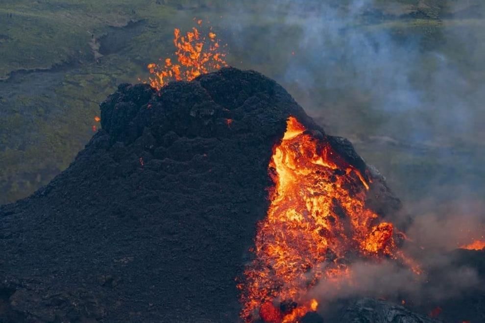
Reykjanes Peninsula Eruption
 Why in News?
Recently, a volcano erupted in southwest Iceland, highlighting a series of geological activities on the Reykjanes Peninsula, which has shown signs of volcanic reawakening.
Key Takeaways
- The Reykjanes Peninsula is located in southwest Iceland along the Mid-Atlantic Ridge where tectonic plates diverge.
- After being dormant for centuries, volcanic activity resumed in 2021, leading to ongoing eruptions.
- The eruptions are characterized by fissure eruptions, where lava flows from cracks in the earth rather than from a central crater.
Additional Details
- Key Sites: Important locations include Grindavik (which has been evacuated), the Blue Lagoon spa, and the Svartsengi power plant.
- Volcanic Importance: The Reykjanes Peninsula is part of Iceland's network of over 30 active volcanic zones.
- Eruption Style: The eruptions produce steady lava flows with minimal ash output, ensuring flight safety as air traffic remains unaffected by stratospheric ash.
- Evacuation Impact: Following the threats from lava flows in 2023, Grindavik has been largely abandoned.
- Long-Term Activity: The current volcanic activity is expected to persist for decades or even longer.
- Iceland Snapshot: The country has a population of approximately 400,000, comparable in size to Kentucky.
- Tourism Appeal: The region attracts visitors similar to other volcanic hotspots around the world, including those in Mexico, Indonesia, Sicily, and New Zealand.
This eruption and the ongoing geological activity on the Reykjanes Peninsula illustrate the dynamic nature of Iceland's landscape and the potential threats and opportunities it presents.
Mount Kilimanjaro
Why in News?
Recently, the Defence Secretary officially inaugurated mountaineering expeditions to Mount Everest and Mount Kilimanjaro during an event held at South Block, New Delhi.
Key Takeaways
- Mount Kilimanjaro is the tallest mountain in Africa and the largest free-standing mountain in the world.
- It is located in northeastern Tanzania, close to the border with Kenya.
- Kilimanjaro comprises three volcanic cones: Kibo, Mawenzi, and Shira.
- Uhuru Peak, situated on Kibo, is the highest free-standing peak in Africa.
- The mountain is renowned for its snow-capped summit.
Additional Details
- Location: Mount Kilimanjaro extends approximately 50 miles (80 km) in an east-west direction and is positioned near the Kenyan border.
- Volcanic Cones: Kibo is the tallest cone and is a dormant volcano, while Mawenzi and Shira are classified as extinct.
- Vegetation Zones:The mountain features five distinct vegetation zones, which include:
- Lower Slopes
- Montane Forest
- Heath and Moorland
- Alpine Desert
- Summit
- Kilimanjaro National Park was designated as a UNESCO World Heritage Site in 1987.
This majestic mountain not only serves as a significant geographical landmark but also as a destination for adventurers and nature enthusiasts, showcasing diverse ecosystems and breathtaking views.
Reykjanes Peninsula Eruption Update
Why in News?
Recently, a volcanic eruption occurred in Iceland's Reykjanes Peninsula, marking the ninth event in the region since late 2023. This uptick in volcanic activity has attracted attention due to its geological significance and implications for the area's landscape and safety.
Key Takeaways
- The Reykjanes Peninsula is located in southwest Iceland and is known for its extensive lava fields and active volcanoes.
- The region has experienced a surge in volcanic activity since 2021, with frequent eruptions and minor earthquakes.
- It is the site of the Reykjanes Geopark, recognized for its unique geological features.
Additional Details
- Geological Features: The peninsula is characterized by a landscape shaped by the Mid-Atlantic Ridge, where the North American and Eurasian tectonic plates converge, leading to high volcanic activity.
- The area covers approximately 829 sq.km and is predominantly covered by moss-coated lava fields and cone-shaped mountains.
- Despite its geological dynamism, the peninsula has a sparse population, primarily concentrated around Reykjavik, the largest city in the region.
- Gunnuhver Geothermal Field: One of the largest geothermal fields in the peninsula, it showcases the area’s geothermal energy potential.
The Reykjanes Peninsula remains a focal point for geological studies due to its active volcanic landscape and the ongoing monitoring of tectonic movements.
Tanimbar Islands Earthquake
Why in News?
Recently, a significant seismic event occurred when an earthquake measuring 6.7 struck off the coast of Indonesia's Tanimbar Islands region, raising concerns about the geological activity in this area.
Key Takeaways
- The earthquake occurred in the Tanimbar Islands located in Indonesia.
- Indonesia is known for its high seismic activity due to its position on the Pacific Ring of Fire.
Additional Details
- Tanimbar Islands: This group comprises around 30 islands, situated in the Indonesian province of Maluku, positioned between the Banda and Arafura seas. The largest island, Yamdena, extends approximately 70 miles in length and 40 miles in width at its broadest point.
- Geography: The eastern coast of Yamdena features thickly wooded hills, while the western coast is characterized by lower, often swampy terrain.
- Seismic Activity: Indonesia lies along the Pacific Ring of Fire, a region where multiple tectonic plates converge, leading to frequent earthquakes and volcanic eruptions.
This recent earthquake highlights the ongoing seismic challenges faced by Indonesia, particularly in the Tanimbar Islands region, which is part of the broader geological dynamics of the area.
Great Trigonometric Survey (GTS)
Why in News?
This newscard highlights the significant contribution of Indian assistants in completing the Great Trigonometric Survey (GTS), which commenced in 1802 to meticulously map the geography of India.
Key Takeaways
- The GTS was an extensive scientific initiative aimed at mapping India with exceptional precision.
- It utilized trigonometry and geodesy, led by British officials under the East India Company.
- Indian assistants played a crucial role in the success of the survey, contributing through various skilled and manual tasks.
Additional Details
- Launch and Objective: The GTS was initiated in 1806 by the British, conceptualized by Colonel William Lambton, to accurately measure the Earth's curvature and create precise maps for colonial administration and scientific research.
- Survey Method: The survey employed triangulation, forming a network of interconnected triangles from a known baseline to calculate distances and angles over extensive areas.
- First Baseline: The initial baseline was established in 1802 at St. Thomas Mount near Madras (Chennai), extending over 2,600 km up to the Himalayas.
- Instruments Used: The survey utilized large theodolites and measuring chains, necessitating substantial manpower for equipment operation and transport.
- Scientific Outcome: This effort led to the formulation of the Everest Spheroid, which remains a vital geodetic reference model in South Asia.
- Duration and Leadership: Originally planned for five years, the project extended to nearly 70 years, concluding in 1871, with leadership transitions including figures like George Everest and Andrew Scott Waugh.
Impact of GTS on Mapping India
- First Accurate Maps: GTS produced scientifically reliable maps that corrected previous inaccuracies, establishing modern geodetic frameworks essential for administration and infrastructure.
- Survey Range: The survey encompassed areas from southern India to the Himalayas, facilitating comprehensive development and precise scientific measurements.
- Great Arc Measurement: It measured a significant geodetic arc from Chennai to Dehradun, aiding in the calculation of Himalayan heights.
- Mount Everest Identification: In 1852, Peak XV was identified as the highest mountain globally, later named in honor of George Everest.
- Latitude-Longitude System: The survey established accurate longitude and latitude coordinates, crucial for navigation and military logistics.
- Infrastructure Impact: Survey benchmarks supported the development of railways, roads, canals, and ongoing earthquake studies, many of which are still relevant today.
Contribution of Indians to the GTS
- Syed Mir Mohsin Husain: A jeweller from Arcot who repaired critical instruments and was later appointed as an instrument maker in the Surveyor General's office.
- Radhanath Sikdar: An Indian mathematician recognized for calculating the height of Mount Everest, confirming it as the tallest peak in the world.
- Indian Field Workers: Thousands of Indian flagmen, khalasis, and laborers performed essential tasks, such as carrying heavy equipment and setting markers under challenging conditions.
- Logistical Support: Indian artisans and technicians played a vital role in repairing, calibrating, and adapting instruments to suit local conditions.
- Role of Pundits: Trained Indian "pundits" conducted secret surveys in politically sensitive regions like Tibet, where British officers were restricted.
The Great Trigonometric Survey stands as a monumental achievement in the history of scientific exploration in India, showcasing the collaborative efforts of both British officials and Indian assistants in shaping the geographical knowledge of the subcontinent.
Fossils Reveal Kashmir Valley’s Climatic Past
Why in the News?
Researchers from the Birbal Sahni Institute of Palaeosciences (BSIP), Lucknow, have discovered compelling evidence indicating that the Kashmir Valley, currently characterized by a cool and temperate climate, was once a warm and humid subtropical region.
Key Takeaways
- The fossils were retrieved from the Karewa sediments in the Kashmir Valley, a site known for its preservation of ancient plant remains.
- Researchers employed the CLAMP (Climate Leaf Analysis Multivariate Program) to analyze the shape, size, and margins of fossil leaves, estimating past temperature and rainfall patterns.
- The coexistence approach compared fossil plants with their modern counterparts to reconstruct the ancient climate of the region.
Additional Details
- Past Climate Type: The research indicates that the Kashmir Valley once experienced a warm, humid subtropical climate, contrasting sharply with its present cool, Mediterranean-type climate.
- Vegetation Evidence: Fossilized leaves revealed a variety of subtropical plant species that are no longer present in the current vegetation of the region.
- Role of Tectonic Uplift: The tectonic uplift of the Pir Panjal Range is identified as a crucial factor that obstructed the Indian summer monsoon from entering the valley, contributing to its climatic transition.
- Climatic Transition: This blockage led to a gradual drying of the area and a significant shift from subtropical forests to temperate ecosystems.
- Impact of Mountain-Building: The study illustrates that mountain-building processes (tectonic uplift) can significantly influence climate patterns by altering monsoon routes.
- Relevance to Climate Change: These findings offer insights into natural climate shifts occurring over millions of years, providing context for contemporary climate change discussions.
- Ecological Vulnerability: The study underscores the susceptibility of mountain ecosystems, such as the Himalayas, to both natural and anthropogenic environmental changes.
The Karewa sediments, consisting of plateau-like terraces formed from lacustrine (lake) and fluvio-glacial deposits, are known for preserving ancient fossils, particularly of plants. Additionally, a subtropical climate is characterized by warm and humid conditions with moderate to high rainfall, supporting dense vegetation, similar to the climate found in northeastern India. In contrast, a Mediterranean-type climate is marked by mild, wet winters and hot, dry summers, as seen in certain parts of the region today.
The findings are crucial as they enhance our understanding of past climatic conditions and their implications for current climate dynamics.
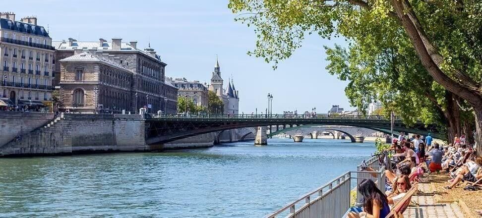
Seine River: A Major Waterway in France
 Why in News?
French authorities have recently permitted public swimming in the Seine River for the first time since 1923, highlighting a significant change in public access to this iconic waterway.
Key Takeaways
- The Seine River is a major waterway in northern France.
- It is the second-longest river in France, measuring approximately 777 km (483 miles).
- The river supports commercial navigation and provides drinking water for Paris.
Additional Details
- Overview: The Seine River flows through some of France's most vital cultural and economic regions.
- Source and Elevation: It originates from the Langres Plateau in Burgundy, near Source-Seine, at an elevation of about 444–471 meters above sea level.
- Course Through France: The river flows northwest, passing through regions like Burgundy and Champagne, and cities including Troyes and Paris.
- Path Through Paris: In Paris, the Seine winds through the city center for about 13 kilometers, forming notable islands such as Île de la Cité and Île Saint-Louis.
- Tributaries: Significant tributaries include the Marne, Yonne, Aube, and Oise rivers.
- Drainage Basin and Rainfall: The Seine's drainage basin covers 76,000–79,000 square kilometers, receiving moderate rainfall of 650–750 mm annually.
- Mouth and Termination: The river empties into the English Channel between Le Havre and Honfleur, located on the Normandy coast.
- Economic Role: The Seine is crucial for commercial navigation, especially through Rouen and Le Havre, and supplies about 50% of Paris's drinking water.
This new initiative to allow swimming in the Seine marks a remarkable shift in the relationship between urban populations and their waterways, emphasizing the importance of environmental management and public health.
Consider the following pairs: River Flows into
- 1. Mekong - Andaman Sea
- 2. Thames - Irish Sea
- 3. Volga - Caspian Sea
- 4. Zambezi - Indian Ocean
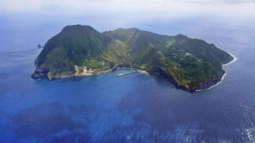
Tokara Islands Earthquake Activity
 Why in News?
Recently, the Tokara Islands in southern Japan have experienced an unprecedented seismic event, with over 1,000 earthquakes occurring in the last two weeks, raising concerns among residents and authorities.
Key Takeaways
- The Tokara Islands are located south of Kyushu and north of the Amami Islands in Japan.
- This archipelago is composed of seven inhabited islands and five uninhabited islands.
- Mount Otake, at 979 meters, is the highest peak in the island group.
- The climate is characterized by warm temperatures and significant rainfall, with low frost occurrence.
Additional Details
- Geographical Significance: The Tokara Islands form part of a seismic zone, making them one of the most seismically active regions globally.
- Inhabited Islands: The seven inhabited islands include Kuchinoshima, Nakanoshima, Suwanosejima, Tairajima, Akusekijima, Kodakarajima, and Takarajima.
- Climate Characteristics: The islands lie between subtropical and temperate zones, featuring an average annual temperature of 20°C and annual rainfall of approximately 2,700 millimeters.
- The administrative division encompassing these islands is known as Toshima-mura.
The ongoing seismic activity has prompted local officials and residents to remain vigilant and prepared for potential aftershocks and further geological events.
Factors Behind Monsoon’s Early Nationwide Arrival
Why in News?
The southwest monsoon has covered the entire country by June 29, which is nine days earlier than the usual date of July 8. Notably, this is only the tenth occurrence since 1960 that the monsoon achieved nationwide coverage in June.
Key Takeaways
- The monsoon's arrival in Kerala on May 24 marked an early onset, laying the groundwork for subsequent rapid progress.
- Monsoon conditions varied across India, with the southern, eastern, and northeastern regions experiencing early arrival, while northwest India was near normal and central India saw slight delays.
Additional Details
- Low Pressure Systems: In June, India experienced five low-pressure systems that acted as moisture magnets, drawing in rain-bearing winds and accelerating the monsoon's movement inland.
- Active Madden-Julian Oscillation (MJO): This is a system of clouds, rainfall, winds, and pressure that travels eastward near the equator. An active MJO phase enhances the monsoon by increasing cloud cover and moisture, leading to stronger rainfall.
- Favourable Monsoon Trough Position: The monsoon trough, an elongated low-pressure area, is crucial for determining rainfall distribution. Its favorable position this year, shifted south of its normal location, facilitated increased moisture inflow and early rainfall across various regions.
- Neutral ENSO Condition: The El Niño-Southern Oscillation (ENSO) is a climate pattern with phases affecting rainfall. A neutral phase, where sea surface temperatures are close to average, supports normal monsoon progression.
- Neutral IOD Conditions: The Indian Ocean Dipole (IOD) is marked by temperature differences in the Indian Ocean. A neutral IOD phase this year resulted in minimal impact on monsoon rainfall, allowing other factors like MJO and ENSO to drive the monsoon.
This year's monsoon has been characterized by its early onset, rapid progression, sudden pauses, and localized weather disasters. As the season continues, it remains uncertain whether these patterns will stabilize or intensify further.
|
175 videos|624 docs|192 tests
|
FAQs on Geography: July 2025 UPSC Current Affairs - Geography for UPSC CSE
| 1. What is the significance of the Reykjanes Peninsula eruption in terms of geological activity? |  |
| 2. How does the eruption of Reykjanes Peninsula affect the surrounding environment and communities? | |
| 3. What are the geological features of Mount Kilimanjaro that make it unique among other volcanoes? | |
| 4. What are the implications of the Tanimbar Islands earthquake for the region and its seismic activity? | |
| 5. What was the purpose of the Great Trigonometric Survey (GTS), and how did it contribute to geography? | |


Previous Year Questions with Solutions
,Geography: July 2025 UPSC Current Affairs | Geography for UPSC CSE
,mock tests for examination
,MCQs
,study material
,Summary
,Viva Questions
,ppt
,shortcuts and tricks
,video lectures
,Semester Notes
,Geography: July 2025 UPSC Current Affairs | Geography for UPSC CSE
,Objective type Questions
,Free
,Exam
,Important questions
,practice quizzes
,Geography: July 2025 UPSC Current Affairs | Geography for UPSC CSE
,Extra Questions
,past year papers
,Sample Paper
;


Geography: July 2025 UPSC Current Affairs Free PDF Download
Importance of Geography: July 2025 UPSC Current Affairs
Geography: July 2025 UPSC Current Affairs Notes
Geography: July 2025 UPSC Current Affairs UPSC Questions
Study Geography: July 2025 UPSC Current Affairs on the App
|
© EduRev
|
Education Revolution
|


|


