Geography: May 2025 UPSC Current Affairs | Geography for UPSC CSE PDF Download
| Table of contents |
|
| Tapti Basin Mega Recharge Project |
|
| Geographical and Climatic Factors Influencing Heatwaves |
|
| IUCN Report on Mangrove Ecosystems |
|
| Early Monsoon Onset 2025 |
|

Tapti Basin Mega Recharge Project
Why in News?
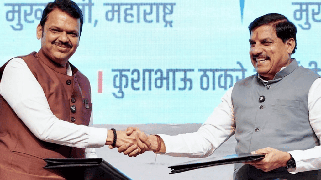
Madhya Pradesh (MP) and Maharashtra have recently signed a memorandum of understanding (MoU) to collaboratively implement the Tapti (Tapi) Basin Mega Recharge Project. This initiative is recognized as the world’s largest groundwater recharge scheme, aimed at maximizing the use of river water resources for irrigation across both states.
Key Takeaways
- The project is a joint inter-state groundwater recharge initiative involving Madhya Pradesh and Maharashtra.
- It focuses on the development of three streams of the Tapti River originating from Multai, MP.
- This is the third major inter-state river project for Madhya Pradesh, following the Ken-Betwa Link Project and the Parbati-Kalisindh-Chambal Link Project.
Additional Details
- Water Allocation:The project aims to divert water from the Tapti River to northeastern Maharashtra for drinking purposes and to support irrigation in southern and southeastern Madhya Pradesh. The total water usage is projected at 31.13 thousand million cubic feet (TMC), with allocations of:
- 11.76 TMC for Madhya Pradesh
- 19.36 TMC for Maharashtra
- The project includes the construction of a diversion weir at the MP-Maharashtra border and the development of right and left bank canals in both states.
- The initiative will utilize 3,362 hectares of land in Madhya Pradesh without requiring displacement or rehabilitation of local populations.
- Beneficiary Districts: The project will benefit districts facing groundwater stress and erratic rainfall, specifically Burhanpur and Khandwa in MP, along with Akola, Amravati, and Buldhana in Maharashtra.
In conclusion, the Tapti Basin Mega Recharge Project is a significant step towards sustainable water resource management in Madhya Pradesh and Maharashtra, aiming to enhance irrigation and provide reliable drinking water in areas facing water scarcity.
Geographical and Climatic Factors Influencing Heatwaves
Why in News?
Andhra Pradesh and Telangana are currently experiencing intense heat waves during the summer season. This phenomenon is attributed to a combination of unique geographical features and climatic conditions prevalent in these regions.
Key Takeaways
- Heat waves occur primarily due to geographical and climatic factors.
- Regions near the Tropic of Cancer experience high solar intensity.
- Urban areas amplify heat effects due to built environments.
Additional Details
- Latitude and Solar Intensity: Areas close to the Tropic of Cancer, such as Andhra Pradesh and Telangana, receive intense solar radiation during summer when the sun is nearly overhead. This results in increased ground heating and significantly raised temperatures.
- Terrain and Surface Characteristics: Rocky and barren landscapes like the Deccan plateau in Telangana absorb more heat compared to vegetated surfaces. The black soils in these areas also retain heat longer, contributing to elevated daytime temperatures.
- Urban Heat Islands: Areas with high population density and extensive concrete surfaces retain more heat, creating localized zones of elevated temperatures, which lead to more intense heat waves.
- Rainfall and Humidity: Low pre-monsoon rainfall results in dry soils and reduced moisture, limiting the cooling effect that evaporation provides. Minimal cloud cover enhances solar radiation, raising surface temperatures and intensifying heat waves.
- Wind and Atmospheric Conditions: Weak winds during heat waves hinder heat dispersion, causing heat to accumulate near the ground and intensifying surface temperatures.
In summary, the interplay of geographical and climatic factors significantly influences the intensity and occurrence of heat waves in regions like Andhra Pradesh and Telangana. Understanding these factors is crucial for developing effective strategies to mitigate the impacts of heat waves.
What are Heat Waves?
Heat waves are defined as periods of unusually high temperatures relative to the normal climate of a region. The criteria for declaring a heat wave varies by location based on historical temperature patterns.
India Meteorological Department (IMD) Criteria for Declaring Heat Wave
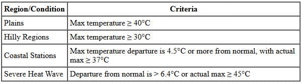
What is the Impact of the Heat Waves?
- Impact on Human Health: Heatwaves lead to a surge in illnesses such as heat cramps, heat exhaustion, and heat stroke, particularly affecting vulnerable populations.
- Economic Impact: Prolonged heat exposure in industries reduces worker efficiency and productivity.
- Environmental Damage: Increased forest fires and decreased water availability due to heat waves harm ecosystems and agriculture.
What are India’s Initiatives to tackle Heat Waves Issue?
- Heat Action Plans (HAPs): Updated across 23 states to manage heat waves effectively.
- IMD Heat Wave Warnings: Issued in collaboration with national disaster management authorities to inform the public.
- Jal Shakti Abhiyan: Focuses on water conservation, critical during heatwave events.
These initiatives demonstrate a proactive approach to mitigating the impacts of heat waves and improving resilience in affected regions.
IUCN Report on Mangrove Ecosystems

Why in News?
The International Union for Conservation of Nature (IUCN) has released a new report warning that half of the world's mangrove ecosystems are at risk of collapse. This is the first comprehensive global assessment of mangroves conducted by the IUCN. The report, titled 'Red List of Mangrove Ecosystems,' presented its findings on the International Day for Biodiversity (22 May).
Key Takeaways
- Over 50% of the world's mangrove ecosystems are at risk of collapse, categorized as vulnerable, endangered, or critically endangered, with nearly 1 in 5 facing severe risk.
- One-third of the world's mangrove ecosystem provinces will be severely affected by sea-level rise, predicting that 25% of the global mangrove area could be submerged in the next 50 years.
- The mangrove ecosystem in South India is classified as 'critically endangered,' while those in the Bay of Bengal and western coast are 'least concerned.'
- Climate change is the primary threat to mangrove ecosystems, affecting 33% globally, followed by deforestation, development, pollution, and dam construction.
- Coastal regions such as the Northwest Atlantic, North Indian Ocean, Red Sea, South China Sea, and Gulf of Aden are predicted to face significant impacts.
- Without increased conservation efforts, an additional 7,065 sq km (5%) of mangroves could be lost by 2050, with 23,672 sq km (16%) submerged.
Additional Details
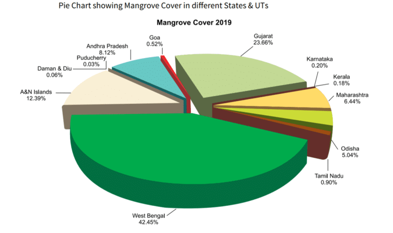
- Current Mangrove Cover in India: Mangroves are unique coastal ecosystems found in tropical and subtropical areas, characterized by salt-tolerant trees and shrubs thriving in intertidal zones. India holds approximately 4,975 sq km of mangrove cover, representing 0.15% of the country’s total geographical area.
- Distribution: West Bengal accounts for 42.45% of India’s mangrove cover, followed by Gujarat (23.66%) and the Andaman & Nicobar Islands (12.39%). The South 24 Parganas district in West Bengal alone holds 41.85% of India’s mangrove cover.
- The mangrove cover in India has increased by 54 sq km (1.10%) compared to previous assessments.
India’s Initiatives for Mangrove Conservation
- Coastal Regulation Zone (CRZ) Notification (2019): This notification classifies coastal areas, restricting activities that could damage mangroves, such as dumping waste, industrial activities, and land reclamation.
- Central Sector Scheme: Aims to provide financial assistance for implementing action plans focused on mangrove conservation, including surveying and awareness campaigns.
- Mangrove Initiative for Shoreline Habitats & Tangible Incomes (MISHTI): Launched in the 2023-24 Union Budget, this initiative promotes mangrove conservation and sustainable development.
- Legal Protection: The Indian Forest Act, 1927, and the Wildlife Protection Act, 1972, provide legal frameworks for the conservation of mangroves.
Significance of the Mangrove Ecosystem
- Biodiversity Conservation: Mangroves provide habitats for various species, including the Royal Bengal tiger and the Irrawaddy dolphin.
- Coastal Protection: They act as natural buffers against erosion and storm surges, protecting inland areas during extreme weather events.
- Carbon Sequestration: Mangroves are efficient carbon sinks, capturing significant amounts of carbon dioxide.
- Fisheries and Livelihoods: They support fisheries by providing nursery areas, thus enhancing productivity and local food security.
- Water Quality Improvement: Mangroves filter pollutants and excess nutrients from coastal waters, maintaining the health of marine ecosystems.
- Tourism and Recreation: They offer opportunities for eco-tourism and nature-based activities, benefiting local economies.
Challenges Faced by Mangrove Ecosystems
- Habitat Destruction: Mangroves are often cleared for agriculture, urbanization, and aquaculture.
- Climate Change: Rising sea levels and extreme weather events threaten mangrove survival.
- Pollution: Contamination from agricultural runoff and industrial waste adversely affects these ecosystems.
- Lack of Integrated Management: Mangroves are often managed in isolation, neglecting their connection with adjacent ecosystems.
- Overfishing: Unsustainable harvesting practices diminish the ecological and economic value of mangroves.
- Invasive Species: Non-native species can outcompete local flora and disrupt ecosystems.
Strategies for Protecting Mangrove Ecosystems
- Stricter Regulations: Implement and enforce laws to prevent pollution and unsustainable development.
- Mangrove Adoption Program: Encourage public involvement in the maintenance and protection of mangrove areas.
- Research and Development: Invest in innovative uses of mangroves, such as phytoremediation.
- Community Involvement: Engage local communities in conservation efforts and sustainable livelihoods.
- Bio-Restoration Techniques: Utilize methods to revive degraded mangrove areas and restore biodiversity.
- Diverse Species in Restoration: Ensure that restoration efforts include multiple mangrove species for resilience against climate change.
Early Monsoon Onset 2025
Monsoon Start Update in India 2025
- On May 24, 2025, the India Meteorological Department (IMD) announced the onset of the monsoon in Kerala, which was eight days earlier than the usual start date of June 1.
- This event signifies the beginning of the southwest monsoon season, which lasts from June to September and is responsible for over 70% of India's annual rainfall.
Criteria for Monsoon Onset Declaration
- Rainfall: At least 60% of 14 specified southern meteorological stations must report a minimum of 2.5 mm of rainfall for two consecutive days.
- Wind Field: Westerly winds should extend to a depth of 600 hPa, with speeds ranging from 27 to 37 km/h at 925 hPa.
- Outgoing Longwave Radiation (OLR): OLR values should be below 200 Watts per square meter.
Factors Influencing Early Monsoon Onset
- Madden-Julian Oscillation (MJO): An eastward-moving atmospheric disturbance that enhances rainfall.
- Mascarene High:. high-pressure area that influences heavy rains along India’s west coast.
- Convection: Increased vertical transport of heat and moisture, leading to enhanced rainfall.
- Somali Jet:. strong cross-equatorial wind band that strengthens monsoon winds.
- Heat-low:. low-pressure area that acts like a suction for moist air, enhancing rainfall.
- Monsoon Trough:. low-pressure area that significantly influences rainfall patterns.
Current Monsoon Progress
- The southwest monsoon has made significant progress, covering the southwest and east-central Bay of Bengal, the Maldives, the Comorin region, and parts of the Arabian Sea.
- It has also reached Kerala, Lakshadweep, Mahe, Mizoram, southern and coastal Karnataka, and Tamil Nadu, continuing its advance into central and eastern regions of India.
- The Northern Limit of Monsoon has moved through several locations, indicating substantial progress into central and northern regions earlier than usual.
|
175 videos|624 docs|192 tests
|
FAQs on Geography: May 2025 UPSC Current Affairs - Geography for UPSC CSE
| 1. What is the Tapti Basin Mega Recharge Project? |  |
| 2. What are the main objectives of the Tapti Basin Mega Recharge Project? | |
| 3. How does the Tapti Basin Mega Recharge Project contribute to sustainable development? | |
| 4. What techniques are being used in the Tapti Basin Mega Recharge Project to improve groundwater recharge? | |
| 5. Who are the key stakeholders involved in the Tapti Basin Mega Recharge Project? | |


Viva Questions
,video lectures
,MCQs
,Exam
,Geography: May 2025 UPSC Current Affairs | Geography for UPSC CSE
,Free
,Semester Notes
,mock tests for examination
,Previous Year Questions with Solutions
,Summary
,study material
,Sample Paper
,Extra Questions
,Important questions
,ppt
,Objective type Questions
,shortcuts and tricks
,past year papers
,Geography: May 2025 UPSC Current Affairs | Geography for UPSC CSE
,practice quizzes
,Geography: May 2025 UPSC Current Affairs | Geography for UPSC CSE
;


Geography: May 2025 UPSC Current Affairs Free PDF Download
Importance of Geography: May 2025 UPSC Current Affairs
Geography: May 2025 UPSC Current Affairs Notes
Geography: May 2025 UPSC Current Affairs UPSC Questions
Study Geography: May 2025 UPSC Current Affairs on the App
|
© EduRev
|
Education Revolution
|


|


within 7 days!