Geography: October 2023 UPSC Current Affairs | Current Affairs & Hindu Analysis: Daily, Weekly & Monthly PDF Download
| Table of contents |

|
| Fragility of Indian Himalayan Region |

|
| Surge in Human Settlements in Flood-Prone Areas |

|
| Glacial Lake Outburst Flood in Sikkim |

|
| More Frequent Cyclones in Eastern Arabian Sea |

|
Fragility of Indian Himalayan Region
Why in News?
The breach of the Teesta dam in Sikkim, causing floods, and the recent landslides in Himachal Pradesh serve as clear indicators of the adverse impact our development model is having on the environment and ecology, particularly in the mountainous Indian Himalayan Region.
What are the Issues in the Indian Himalayan Region (IHR)?
- Flaws in Graded Approach:
- Specified flaws in the graded approach of the Indian regulatory system, such as Ministries and Departments emphasise that the IHR is not given special consideration, despite its ecological significance.
- The Himalayas are prone to extreme weather conditions, seismic activity, and the effects of climate change, yet there are no differentiated environmental standards for projects in this region.
- Issues in Implementation of Different EIA Stages:
- There is a profound lack in addressing the IHR's needs at all stages of the Environment Impact Assessment (EIA) process, from screening to appraisal, by aligning project requirements with the region's ecological needs.
- The inclusion of clauses in the EIA notification to account for specific characteristics of projects in mountainous areas so as to elevate their liability is also lacking.
- Lack of National Level Regulator:
- One significant issue in the EIA process is the absence of a national-level regulator, which was suggested by the Supreme Court in 2011 in Lafarge Umiam Mining (P) Ltd. and T.N. Godavarman Thirumulpad vs Union of India,1995
- Currently, EIA processes tend to favor project proponents, and there is a lack of comprehensive consideration of cumulative impacts, especially in mountainous areas like the IHR.
- Issue of Uniformity in EIA 2006 Notification:
- The EIA 2006 notification categorizes projects based on sectors like mining, power generation, and infrastructure, but the threshold limits for requiring an EIA remain the same across the country.
- This uniform approach fails to consider the unique needs and vulnerabilities of the Indian Himalayan Region (IHR), despite its ecological importance and fragility.
- Issues in Draft EIA 2020 Notification:
- The EIA process has evolved with several amendments over the years, with a draft EIA in 2020 raising concerns about being perceived as pro-industry and neglecting ecological considerations. The EIA, when used diligently, can be a potent tool for environmental governance and sustainable development.
What are the Steps Required to Safeguard the Ecological Fragility of IHR?
- Tailored Environmental Standards:
- Establish differentiated environmental standards, considering the fragility and vulnerability of each region.
- Integrate these standards into the Environment Impact Assessment (EIA) process to subject projects in the Indian Himalayan Region (IHR) to more rigorous regulations and scrutiny.
- Strategic Environmental Assessment (SEA):
- Implement SEA to evaluate the cumulative impact of development in a given area.
- Integrate SEA into the clearance process to provide a comprehensive understanding of the potential consequences of development activities in the IHR.
- Local Community Engagement:
- Involve local communities in the decision-making process due to their deep understanding of the region's ecology.
- Ensure participation to enhance the ecological and social responsibility of projects in the IHR.
- Ecosystem-Based Approaches:
- Adopt ecosystem-based approaches, recognizing the IHR's role in maintaining ecological balance.
- Prioritize policies for the protection and restoration of ecosystems, including forests, rivers, and biodiversity.
- Revised Infrastructure Development:
- Plan infrastructure projects in the IHR meticulously, subjecting them to rigorous assessments.
- Explore alternative technologies and routes to minimize environmental impact, especially for dams, roads, and hydropower plants.
- Cross-Border Collaboration:
- Engage in regional cooperation to address ecological challenges that transcend political boundaries.
- Collaborate with neighboring countries to mitigate transboundary issues like air and water pollution in the Himalayan region.
- Public Awareness and Education:
- Raise public awareness about the ecological significance of the IHR.
- Promote education and advocacy to encourage responsible behavior and decision-making among individuals, corporations, and policymakers.
- Nature-Based Tourism Practices:
- Develop sustainable and responsible tourism practices in the IHR.
- Promote eco-tourism, enforce carrying capacity limits, and educate tourists to minimize negative environmental impacts while generating income for local communities.
What is Draft Environment Impact Assessment (EIA) Notification 2020?
- About:
- The Draft EIA Notification 2020, when it was introduced, aimed to replace the previous EIA Notification of 2006.
- Post-facto Clearance:
- The draft notification introduced the concept of post-facto clearance, which would allow certain projects to seek environmental clearance even after they had begun operations without clearance.
- Reduced Public Participation:
- Critics argued that the draft notification weakened the public consultation process, making it more challenging for concerned citizens and communities to voice their opinions and objections regarding proposed projects.
- Exemptions for Certain Projects:
- The draft notification proposed exemptions for certain categories of projects, allowing them to bypass the EIA process.
- Extension of Project Validity:
- It suggested extending the validity period of environmental clearances for various projects, potentially reducing the need for frequent re-evaluations of environmental impacts.
- Dilution of Compliance Reports:
- There were concerns about the dilution of compliance reports, which are meant to ensure that projects adhere to environmental conditions and standards.
- The draft notification generated dubious standards, with environmental activists, experts, and concerned citizens voicing their objections.
Surge in Human Settlements in Flood-Prone Areas
Why in the news?
- A World Bank-led study published in Nature journal highlighted a significant increase in human settlements in flood-prone areas since 1985.
- Summer monsoons caused extensive flooding in Indian cities like Bengaluru, Gurugram, and Mumbai.
- Urban floods have led to substantial economic losses, with a State Bank of India report estimating damages up to Rs 15,000 crore due to floods and cyclones in 2023.
Key Findings – World Bank Study
- Increased Settlements in Flood-Prone Areas: The study found that human settlements in areas at high risk of flooding have more than doubled over the last four decades, primarily due to the rapid and unchecked expansion of cities.
- Regional Differences: There are variations in the rate of settlement expansion into flood-prone areas by region. East Asia has experienced the highest rate of such expansion, while Sub-Saharan Africa and North America have had the least.
- Middle-Income Countries at Higher Risk: Middle-income countries, including India (categorized as a low-middle-income country by the World Bank), show a higher tendency of urban settlement in flood-prone zones compared to low- and high-income countries.
- India's Global Position: While India is not among the top 20 countries with the most settlements exposed to flood hazards, it is a significant contributor to global settlements and ranks third after China and the United States in this regard. Additionally, it is third among countries with new settlements expanding into flood-prone areas between 1985 and 2015.
- Data Granularity Issues: There are concerns about the granularity of the data used for the study. The EM-DAT database records mass disasters but is not a detailed floodplain record, which might limit the ability to analyze flood-prone areas with high precision.
What is Urban Flooding?
- Urban flooding is the inundation of land or property in a built environment, particularly in more densely populated areas, caused by rainfall overwhelming the capacity of drainage systems, such as storm sewers.
- Unlike flooding in rural areas, which can spread over large areas, urban flooding is confined to smaller areas, often in specific neighborhoods or city streets.
- The consequences of urban flooding are often severe, including damage to infrastructure, homes, and businesses, disruption of transportation systems, contamination of water supplies, and sometimes loss of life.
- Managing urban flooding requires integrated approaches that include proper urban planning, investment in infrastructure, and the adoption of sustainable drainage and landscape management practices.
Causes of Urban Flooding
- High Intensity Rainfall: Short periods of intense rainfall can lead to flash floods, as the water is unable to percolate into the ground quickly enough and the drainage systems cannot cope with the volume of water.
- Inadequate Drainage: Many urban areas have drainage systems that are inadequate for the demands placed upon them, especially in older or poorly maintained infrastructures.
- Impermeable Surfaces: Urban areas have a high proportion of impermeable surfaces such as concrete and asphalt, which prevent water from naturally soaking into the ground.
- Lack of Natural Waterways: The channelization of creeks and the construction over natural waterways can obstruct the natural flow of water, leading to flooding.
- Poor Urban Planning: In some cases, cities expand rapidly without adequate planning for drainage and flood management, which can lead to development in flood-prone areas.
- Climate Change: Increasingly, urban flooding is exacerbated by climate change, which is associated with more frequent and severe weather events, including intense rainfall.
- Blocked Drains and Waterways: Litter, debris, and sediment can block drains and channels, reducing their effectiveness and leading to water backing up.
Concerns Regarding Urban Planning
- Unsustainable Urban Expansion: Cities have expanded rapidly into areas without adequate consideration of natural topography and hydrology, leading to development in flood-prone zones.
- Overlooking Topography: New localities often disregard the natural lay of the land, such as valleys and ridges, which are inherently more susceptible to flooding, resulting in greater risk and damage during flood events.
- Impervious Surfaces: The increase in concrete cover reduces the ground’s ability to absorb rainfall, exacerbating runoff and the potential for flooding.
- Inadequate Drainage Infrastructure: Urban areas, especially those that have expanded quickly, may lack sufficient stormwater management systems, making them more susceptible to flooding.
- Governance and Regulatory Challenges: Environmental regulations, when applied, tend to focus on large infrastructure projects, often overlooking smaller-scale developments that collectively contribute to the area’s flood risk.
- Violation of Regulations: There is a common issue of non-compliance with existing government regulations, where construction occurs in ecologically sensitive areas or floodplains without appropriate approvals or oversight.
- Recognition of Risk Areas: There is a need for a clear identification and acknowledgment of flood-prone areas to inform and guide sustainable urban expansion and planning.
Expansion of Urban Settlements – Global Context
- As per the study led by the World Bank, there is a marked increase in urban settlements in areas prone to flooding.
- Over four decades, since 1985, there has been more than a doubling of human settlements in such vulnerable zones.
- The study utilized satellite data to examine flood patterns and urban expansion, revealing significant spatial variations in the trends of such developments.
- East Asia was identified as the region with the highest rate of urban settlement expansion into flood-prone areas, while Sub-Saharan Africa and North America were among the regions with the least expansion into such hazardous zones.
- Middle-income countries were found to have more urban settlement in flood-prone zones compared to low- and high-income countries, positioning India as a significant example, being classified as a low-middle-income country.
- While India is not among the top 20 countries most exposed to flood hazards, it is a major contributor to global urban settlements and is significantly expanding into flood-prone areas, ranking third after China and Vietnam in this regard.
Socioeconomic Disparities
- Impact on Low-Income Groups: The informal settlements, which often house lower-income groups, are disproportionately located in low-lying, flood-prone areas.
- Inequality in Urban Expansion: Both elite and poor populations are expanding into flood-prone zones. However, the risk is greater for those in informal housing due to the lack of resilient infrastructure.
- Governance and Regulation Challenges: There is an indication that environmental regulations, when applied, tend to focus on large infrastructure projects rather than medium and small-scale modifications that affect localities.
- Violations of Regulations: The government regulations are often violated, with instances such as the construction of eco-tourism resorts on forest land and buildings on floodplains.
Governance Challenges
- Inadequate Urban Planning: The rapid and haphazard urbanization in India, particularly in flood-prone areas, points to a lack of foresight in urban planning.
- Inefficient Data Utilization: There is a challenge in employing accurate and granular data for assessing flood risks in urban and peri-urban areas.
- Environmental Regulation Compliance: Governance issues also arise from the selective application of environmental regulations.
- Socioeconomic Disparities: The disproportionate impact of floods on different socioeconomic classes, especially the informal low-income housing, underscores a governance failure to protect vulnerable populations.
- Ineffective Enforcement of Regulations: The widespread violation of environmental and urban regulations indicates a governance issue in enforcement mechanisms.
- Recognition of Locality-Specific Risks: The governance approach tends to overlook the fact that flooding is a locality-level issue, often leading to a 'one size fits all' strategy in urban planning and disaster management that fails to address the unique risks of specific localities.
- Inclusive Adaptation Strategies: There is a need for governance that promotes adaptation strategies inclusive of all income groups.
- Infrastructure Management: The governance challenge extends to urban infrastructure management, particularly in creating and maintaining storm-water management systems that are adequate for the increased risk of flooding due to urban expansion.
Recommendations for Mitigation
- Scientific Mapping of Flood-Prone Areas: There is a need for accurate and scientific mapping of areas that are vulnerable to flooding to understand the extent and frequency of the risk.
- Storm-Water Management Plans: Improved storm-water management systems are necessary, with a focus on installing more efficient storm-water drains to collect and divert rainwater in flood-prone areas.
- Regulation and Governance: Urban governance processes need to address the expansion into flood-prone areas by enforcing environmental regulations, not just for large infrastructure projects but also for medium- and small-scale developments.
- Protecting and Upgrading Low-Income Housing: Urban governments should make existing housing in flood-prone areas more resilient.
- Awareness of Expansion into Flood-Prone Areas: Recognizing and understanding that urban expansion is happening in flood-prone areas is a vital first step towards sustainable urban planning that mitigates associated risks.
- Differentiated Adaptation Strategies: Adaptation measures must take into account the differences between low-income residents and unauthorized structures for the elite.
- Confront Market Forces: There should be a confrontation of market forces that tend to push urban expansion into flood-prone areas.
- Local-Level Focus: Rather than viewing flooding as a generalized issue, it should be addressed at the locality level, recognizing that some areas are more prone to flooding than others due to their specific geographical and developmental conditions.
- Resilient Urban Design: Urban design and construction should consider topography and ecological sustainability, minimizing the concretization of areas that impede natural water flow.
- Community Engagement: Engage with communities, especially those in informal settlements, to ensure that their needs and knowledge are incorporated into planning and that they have secure housing options.
- Enforce Regulations: Enforce existing government regulations strictly to prevent unauthorized construction on floodplains and other ecologically sensitive areas.
Conclusion
Urban areas will inevitably expand into flood-prone regions, but recognizing this is key to sustainable planning. Differentiation in adaptation strategies for low-income housing and unauthorized structures is needed.
Glacial Lake Outburst Flood in Sikkim
Context
Fourteen people have died, and 102, including 23 Army personnel, are missing in Sikkim after the burst of the South Lhonak Lake, a glacial lake in North Sikkim, due to heavy rains.
- The released water created flash floods in four districts, including Mangan, Gangtok, Pakyong, and Namchi, through the Teesta River.
What are Glaciers?
Glaciers are large masses of ice that form from the accumulation and compaction of snow over long periods. They flow slowly downhill under their weight and gravity, shaping the landscape and playing a crucial role in Earth’s climate and hydrology by storing and releasing freshwater. Glaciers cover ∼10% of the Earth’s land surface, but they are shrinking rapidly across most parts of the world, leading to cascading impacts on downstream systems.
What is Glacial Lake outburst flood (GLOF)?
Retreating glaciers, like several in the Himalayas, usually result in the formation of lakes at their tips, called proglacial lakes, often bound only by sediments and boulders. If the boundaries of these lakes are breached, it can lead to large amounts of water rushing down, the way by picking up sediments, rocks, and other materials. A majority of the glaciers in the Himalayas are known to be receding, all leading to the formation of several glacial lakes.
Why are they so dangerous?
The rapid onset and high discharge of GLOFs means there is often insufficient time to effectively warn downstream populations and for effective action to be taken. Also, they often become triggers for other disasters (Cascading disasters) 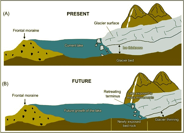
Recent findings about GLOF
- Rapid deglaciation(primarily due to global warming) over the last 20 years has led to the growth of many large glacial lakes.
- There has been an increase in the population living in close proximity to glacial lakes between 2002 and 2022.
- According to the ICIMOD, Himalayan glacial lakes increased by about 9% in number, and 14% in the area.
- GLOFs are recognized in the National Disaster Management Plan (NDMP) 2019 of India as a potential climatological disaster.
A cascade of Events: What happened in Sikkim?
The incessant rain due to the cloudburst led to the outburst of South Lhonak glacial lake. The lake burst resulted in a sudden rise in the water level of the Teesta River and a flash flood. This further led to the breach of the Chungthang Hydro-Dam in Sikkim. Damage to the dam further exacerbated the situation. 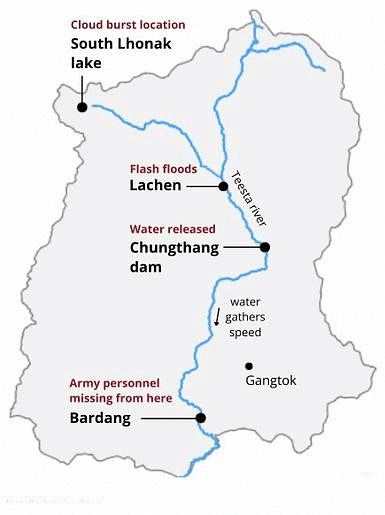
What are Cascading disasters?
It refers to the cascading effects of extreme events in which the vulnerabilities overlap and interact, reaching escalation points which then create secondary effects with greater impact than the primary event.
E.g., the Nanda Devi glacier outburst (2021) triggered landslides, avalanches, deluges, and flash floods in the intricately linked tributaries of the Ganga River.
Reasons behind GLOF and its increased frequency:
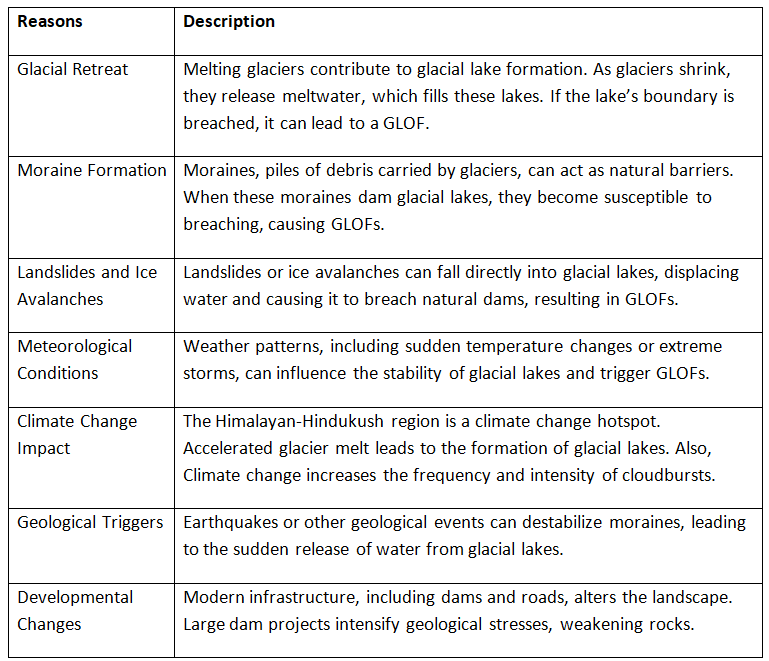
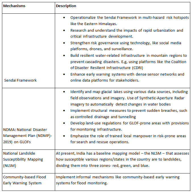
Key preparedness mechanisms to reduce the risk of Glacial Lake Outburst Floods (GLOFs):
Conclusion
As the Sendai Framework advocates, there is a need for a shift of approach from managing the disasters (cure) to managing the risks (prevention). A robust early warning system; a broad framework for infrastructure development, construction, and excavation in vulnerable zones; building the resilience of the communities; and prioritizing disaster risk reduction as an integral part of development planning are the measures much in need now, to manage the risks with cascading disasters.
More Frequent Cyclones in Eastern Arabian Sea
Why in News?
Recently, a study has been published in the Nature Journal, which highlights the concerns related to Climate Change causing frequent Tropical Cyclones (TC) in the Eastern Arabian Sea.
- The study is part of the "Forecasting with Fisher's" project, by the Advanced Centre for Atmospheric Radar Research (ACARR) at Cochin University of Science and Technology (CUSAT).
What are the Key Findings of the Study?
- Increasing Frequency and Severity of Cyclones:
- Changes in ocean and atmosphere warming patterns are leading to more frequent and severe tropical cyclones in the Eastern Arabian Sea, adjacent to India’s west coast.
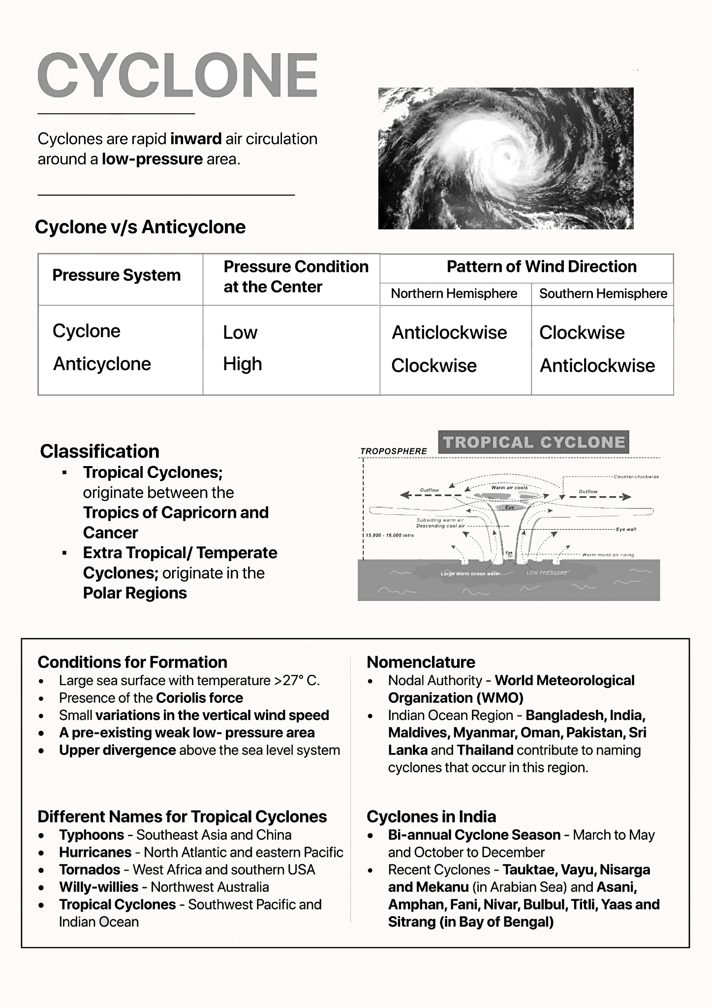
- Typically, tropical cyclones in the Arabian Sea occur at the start of the southwestern monsoon between March and June, as well as after the season, between October and December.
- The Arabian Sea accounts for about 2% of the annual global mean of tropical cyclones but poses a considerable threat due to its densely populated coastlines.
- Impact of Indian Ocean Dipole (IOD):
- The positive phase of IOD, where one part of the ocean gets warmer than the other, leads to warmer sea surface temperatures and increased precipitation in the western Indian Ocean region.
- IOD, sometimes referred to as the Indian Nino, is similar to the El Nino phenomenon, occurring in the relatively smaller area of the Indian Ocean between the Indonesian and Malaysian coastline in the east and the African coastline near Somalia in the west.
- Anthropogenic Influence:
- The recent increase in the frequency of extremely severe cyclonic storms over the Arabian Sea during the post-monsoon season is attributed to anthropogenic (human-caused) influence rather than natural variability.
- Human-induced climate change is contributing to the intensification and higher frequency of cyclones in the Arabian Sea.
- Impact on Western Indian Coastline:
- The intensification and increase in cyclone frequency pose a significant threat to the densely populated coastal regions along the western coast of India, from Gujarat to Thiruvananthapuram, facing higher risks, including strong winds, storm surges, heavy rainfall, and other associated hazards.
- Concerns for Coastal Communities:
- The changing cyclone patterns are expected to significantly affect the lives and livelihoods of indigenous coastal communities and artisanal fishers, necessitating a need for further studies and adaptation strategies.
- Recommendations:
- The study calls for changes in development strategies to account for increased cyclone risks and emphasizes the need for updated policies and technologies related to storm warnings and localized weather services.
What are Cyclones?
|
63 videos|5408 docs|1146 tests
|


