Growth, Distribution & Density of Population | Geography Optional for UPSC (Notes) PDF Download
Population Distribution and Density in India
- The population distribution in the world or any country, including India, is not uniform. Some areas have a high population density, while others have a moderate or low population density. India's population distribution is characterized by this unevenness.
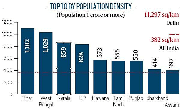
- Population density refers to the number of people per square kilometer. According to the 2011 Census, the average population density in India is 382 persons per square kilometer. However, this number does not imply that each square kilometer in India has precisely 382 people. In reality, the population density varies significantly across different regions in the country.
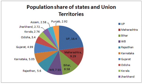
- The uneven population distribution in India can be attributed to the varying sizes of states and the differences in their resource bases. The top five most populous states, namely Uttar Pradesh, Maharashtra, Bihar, West Bengal, Andhra Pradesh, and Telangana, account for half of India's population. In contrast, states like Jammu and Kashmir, Arunachal Pradesh, Sikkim, and the northeastern states have much smaller populations.
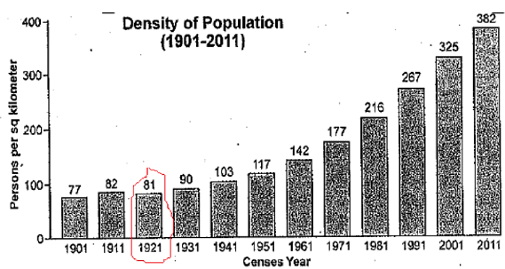
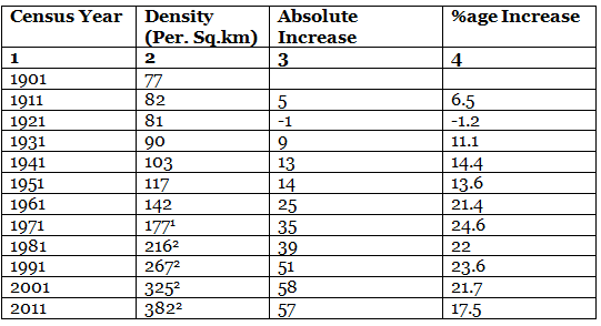
- Over the past 100 years, India's population density has increased more than fourfold, rising from 77 in 1901 to 382 in 2011. This growth highlights the uneven distribution of population within the country. For example, in Arunachal Pradesh, the population density is only 17 persons per square kilometer, whereas, in Delhi, it is 11,297 persons per square kilometer, according to the 2011 Census.
In summary, India's population distribution is highly uneven across its regions, with some areas having very high population densities and others having very low densities. This unevenness can be attributed to the varying sizes of states and the differences in their resource bases.
 Density Graph
Temporal Analysis
- Density of India decreased during 1911-21. Year 1921 is known as the year of the great divide.
 India : Density of population (1901-2011)
Spatial Distribution of Population
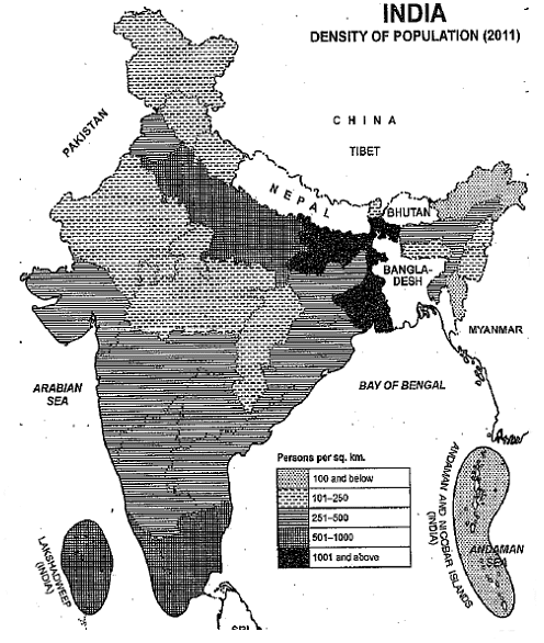
Spatial distribution of population density is classified into the following categories:- Areas of Extremely Low Density
- Areas of Low Density
- Areas of moderate Density
- Areas of high Density
- Areas of very high Density
Areas of Extremely Low Density:
- Areas with extremely low population density are those with 100 people per square kilometer or fewer. Examples of such areas in India include Arunachal Pradesh (17), Mizoram (52), Andaman and Nicobar Islands (46), and Sikkim (86). Arunachal Pradesh and Mizoram are situated in remote and hard-to-reach regions of northeastern India, which contributes to their low population density.
- Sikkim, on the other hand, is characterized by a mountainous terrain, making it difficult for a large population to settle there. The Andaman and Nicobar Islands are located far from the Indian mainland, and their hot and humid climate is detrimental to human health. As a result, these islands have experienced limited economic development, which further contributes to their low population density.
Areas of Low Density:
- Regions with a population density of 101 to 250 people per square kilometer are classified as low-density areas. These include the Indian states of Nagaland (119), Manipur (122), Himachal Pradesh (123), Jammu and Kashmir (124), Meghalaya (132), Chhattisgarh (189), Uttarakhand (189), Rajasthan (201), and Madhya Pradesh (236).
- Meghalaya, Manipur, and Nagaland, located in the northeastern part of India, are characterized by hilly terrain, dense forests, and a dissected landscape. These areas face similar challenges as Arunachal Pradesh and Mizoram, though to a lesser extent.
- Himachal Pradesh and Uttarakhand are situated in the northwestern Himalayan region, which has limited flat land to support a high population density. Jammu and Kashmir have vast uninhabited areas, with only some parts of the Jammu region and the Kashmir valley being densely populated. The regions of Leh (Ladakh) and Kargil in Jammu and Kashmir have extremely low population densities due to their dry and cold climates, which lack basic amenities. Specifically, Kargil has a population density of 10 people per square kilometer, while Leh (Ladakh) has only 3 people per square kilometer.
- Rajasthan, the largest state in India, has significant variations in population density across its regions, depending on local conditions. Most of the state consists of sandy deserts with limited water resources, resulting in low population density. The western parts of Rajasthan have even fewer than 50 people per square kilometer, while the eastern and northeastern regions have more resources and a relatively higher population density.
- Madhya Pradesh, part of the Deccan Plateau, features a rugged landscape with hard rocks, contributing to its low population density. Similarly, Chhattisgarh has a rugged topography, dense forests, and is predominantly inhabited by tribal people, resulting in a low population density in this state as well.
Areas of Moderate Density
- This class includes those areas which are having 251 to 500 persons per sq km. The average for the whole of India (382 persons per sq km) also falls in this class.
- Odisha (269), Gujarat (308), Andhra Pradesh including Telangana (308), Karnataka (319), Tripura (350), Maharashtra (345), Goa (394), Assam (397), and Jharkhand (414) are included in this category.
- These areas are wide apart from one another and there are different reasons for moderate density of population in different areas. For example. Assam has tea estates whereas Andhra Pradesh, Telangana, Odisha, Karnataka, and Jharkhand have agricultural and mineral resources.
- Maharashtra is a highly urbanized and industrialized state. The neighboring state of Gujarat also has urban and industrial growth, although at a scale smaller than that of Maharashtra.
- Among North Eastern states Tripura has sufficient level land which supports moderate population density.
Areas of High Density:
- These are areas having a population density of 501 to 1000 per sq km. States and union territories included in this category are Punjab (550), Tamil Nadu (555), Haryana (573), Dadra & Nagar Haven (698), Uttar Pradesh (828), and Kerala (859).
- Punjab and Haryana have highly developed agriculture based on heavy inputs in the form of high-yielding varieties of seeds, chemical fertilizers, and canal and tube-well irrigation.
- Similarly, Tamil Nadu’s population is based on agriculture and industries. The coastal plain of Kerala is also very fertile. However, Kerala has started showing a decline in the growth rate of the population.
- Uttar Pradesh is located in the fertile Ganga Plain and supports high population density.
Areas of Very High Density:
- Areas with over 1,000 people per square kilometer are considered to have an extremely high population density. West Bengal (1,029), Bihar (1,102), Lakshadweep (2,013), Daman & Diu (2,169), Pondicherry (2,548), Chandigarh (9,252), and Delhi (11,297) are examples of regions with very high population densities, which can be attributed to various factors.
- Bihar, for instance, is situated in the fertile Ganga plains, which supports its high population density. Despite efforts to control population growth, Bihar has now overtaken West Bengal as the state with the highest population density among major Indian states.
- West Bengal, on the other hand, is located in the Ganga delta, one of the world's most fertile regions, where up to four rice crops can be grown each year. Additionally, the Hugli basin, India's largest industrial cluster, is situated here. These factors contribute to West Bengal's status as the second most densely populated state in India.
- Delhi, among the union territories, has witnessed rapid population growth, leading to a significant increase in its population density. This growth is primarily due to the large-scale migration of people from surrounding areas who are in search of better livelihoods and improved living conditions.

Causes of Uneven Distribution of Population
Physical:
- Physical factors such as climate, terrain, and water availability significantly influence the distribution of populations.
- As a result, areas such as the North Indian Plains, deltas, and coastal plains tend to have higher population densities than the interior regions of southern and central Indian states, the Himalayas, and some northeastern and western states.
- However, improvements in irrigation (e.g., Rajasthan), access to mineral and energy resources (e.g., Jharkhand), and the development of transportation networks (e.g., Peninsular states) have led to increased population concentrations in areas that were previously sparsely populated.
Socio-economic and historical factors:
- Socio-economic and historical factors play a significant role in the distribution of the population. Key factors include the evolution of settled agriculture, agricultural development, human settlement patterns, the development of transportation networks, industrialization, and urbanization. It has been observed that regions in India with river plains and coastal areas have consistently had higher population concentrations.
- Despite showing signs of land and water resource degradation, these regions maintain high population concentrations due to their early history of human settlement and the development of transport networks. In contrast, urban areas such as Delhi, Mumbai, Kolkata, Bangalore, Pune, Ahmedabad, Chennai, and Jaipur have high population concentrations due to industrial development and urbanization, which attract large numbers of rural-urban migrants.

Factors Influencing Distribution and Density of Population

While some scholars attach more importance to natural factors Clarke and Zelenskey are of the view that cultural factors are more prominent in determining the concentration of population in an area.
According to Clarke the economic conditions, technological developments, social organization, government policy play a vital role in the distribution of the population.
Major factors influencing the distribution and density of population are described as under:
Terrain:
- Terrain of land is a potent factor that influences the concentration and growth of the population. Normally speaking, plain areas encourage a higher density of population as compared to mountain regions. The steep slopes in mountain areas restrict the availability of land for agriculture, development of transport, industries, and other economic activities which may tend to discourage the concentration of population and its proper growth.
- It is because of these adverse circumstances that the Himalayan region, though occupies about 13 percent of India’s land area, supports only 1-2 percent of the country’s population, in contrast to this, the Great Plain of North India is a land of extremely gentle slope and offers great opportunities for the growth of agriculture, transport, and industries. This results in a higher concentration of population.
- Although the Great Plain of North India has less than 1/4th of the area but has more than 50% of the population.
Climate:
- Climate plays a crucial role in influencing population distribution, just as much as the terrain does. The two most significant climatic factors that determine population density are rainfall and temperature. Human habitation is restricted by climatic extremes, with areas experiencing very cold climates, such as the Himalayas, or extremely hot and dry climates, like the Thar Desert, having lower population densities.
- On the other hand, regions with moderate climates are more conducive to population growth. Among the two factors, rainfall has a greater impact on population distribution. It is often said that India's population map closely follows its rainfall map. Rainfall provides the water necessary for agriculture, which is the primary occupation for the majority of India's population. As one moves from the Ganga-Brahmaputra Delta in the east towards the Thar Desert in the west, both rainfall and population density decrease.
- However, there are some exceptions to this general trend. The Assam Valley in the northeast and the Circars coast on the Bay of Bengal have moderate population densities despite receiving heavy rainfall. Likewise, the southern face of the Himalayas is sparsely populated even though it receives substantial rainfall. In these cases, other factors such as steep slopes, frequent floods, infertile soils, and dense forests negate the positive effects of rainfall.
- In contrast, the increased use of irrigation facilities in northwest India, including Punjab, Haryana, and western Uttar Pradesh, has led to a higher concentration of population than would normally be expected considering the region's rainfall levels.
Soil:
- Soil plays an important factor for the agrarian economy.
- The fertile soil of North India plains, the coastal plains and the black soil region of the Deccan plateau are densely populated.
Water bodies:
- Population is generally concentrated in river valleys.
- Water is needed for agriculture, irrigation, industries, and domestic purpose.
Mineral resources:
- The availability of mineral resources also determine the population density of an area
- For e.g. Chotanagpur region is rich in minerals comprised of high population density.
Industries:
- One hectare of industrial land is capable of supporting several 1000 persons.
- E.g. West Bengal, Bihar, Jharkhand, Orissa, Maharashtra, Gujarat, etc.
Transport:
- Transportation and communication systems play a crucial role in influencing the population density of a region. For example, the Northern plains have a well-developed network of roads and various transportation options, resulting in a higher population density.
- In contrast, the peninsular plateau has a less extensive transportation infrastructure, leading to a lower population density in the area.
Urbanization:
- Urbanization is closely linked to population concentration, as both involve a high density of people living in a particular area. In order for a region to be considered urban, it must have a minimum density of 400 individuals per square kilometer.
- Major urban districts, such as Kolkata, Chennai, Greater Mumbai, Hyderabad, Delhi, and Chandigarh, have population densities exceeding 6,000 persons per square kilometer. According to the 2011 census, Delhi has the highest population density among these cities, with 11,297 individuals per square kilometer.
Conclusion
In conclusion, India's population distribution and density are highly uneven, influenced by various factors such as terrain, climate, water availability, soil fertility, mineral resources, industrialization, transportation, and urbanization. Regions with favorable conditions, such as the North Indian Plains and coastal areas, tend to have higher population densities, while areas with challenging conditions like the Himalayas and Thar Desert have lower densities. As India continues to undergo rapid urbanization and industrialization, understanding these factors and addressing the challenges posed by uneven population distribution is crucial for sustainable development and inclusive growth.Frequently Asked Questions (FAQs) of Growth, Distribution & Density of Population
What is the average population density in India according to the 2011 Census?
The average population density in India according to the 2011 Census is 382 persons per square kilometer.
Which state in India has the highest population density, and what is the main reason for this high density?
Bihar has the highest population density among major Indian states, with 1,102 persons per square kilometer. The main reason for this high density is its location in the fertile Ganga plains, which supports a large agricultural population.
How does climate affect population distribution and density in India?
Climate plays a crucial role in influencing population distribution and density in India. Areas with moderate climates are more conducive to population growth, while areas experiencing extreme cold or hot and dry climates have lower population densities. Rainfall is also a critical factor, as it provides the water necessary for agriculture, which is the primary occupation for the majority of India's population.
How do industries and urbanization contribute to the population density in India?
Industries and urbanization have a significant impact on population density in India. Industrial development attracts people from rural areas seeking better livelihoods and improved living conditions, leading to a higher concentration of population in urban districts. Major urban districts such as Kolkata, Chennai, Greater Mumbai, Hyderabad, Delhi, and Chandigarh have population densities exceeding 6,000 persons per square kilometer.
How does the availability of water bodies affect population distribution in India?
Water bodies greatly influence population distribution in India. Areas with abundant water resources, such as river valleys, tend to have a higher population concentration as water is needed for agriculture, irrigation, industries, and domestic purposes. Conversely, regions with limited water resources have lower population densities due to the challenges of supporting large populations.
|
191 videos|377 docs|117 tests
|
FAQs on Growth, Distribution & Density of Population - Geography Optional for UPSC (Notes)
| 1. What is population distribution and density in India? |  |
| 2. What are the causes of uneven distribution of population in India? |  |
| 3. How does population growth affect population distribution and density in India? |  |
| 4. What are the consequences of uneven population distribution in India? |  |
| 5. How does the Indian government address the issue of uneven population distribution? |  |

