Isostasy | Geography Optional for UPSC PDF Download
Define Isostasy
Isostasy, derived from the Greek words 'iso-stasios' meaning 'equal standing,' is a term first proposed by American geologist Clarence Dutton in 1889. It refers to the state of balance that exists between the Earth's large upstanding features, such as mountain ranges and plateaus. The theory behind isostasy suggests that the Earth's lighter surface materials (sial) float on top of the denser magma (sima) found in the Earth's interior.
- As we explore deeper into the Earth, we find various concentric layers, with the densest material forming the core and the lightest material making up the Earth's surface. Each layer and surface feature rests on one another, maintaining an isostatic balance. For instance, the core has an average density of 13.5 gm/cm3, the mantle's density ranges from 3.3 to 5.7 gm/cm3, and the continental crust's density is around 2.7 gm/cm3.
- The concept of isostasy is particularly useful for explaining the 'glacial adjustment' observed in Scandinavian countries following the Pleistocene great ice age. The raised beaches of Finland, for example, demonstrate that an uplift of about 250 meters has occurred over the last 8,000 years due to isostatic adjustment.
Development of the Isostasy Concept
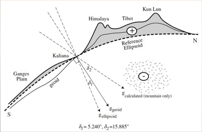
The concept of isostasy was developed by geologists to explain the gravitational attraction of massive mountainous regions. The idea was first introduced when Pierre Bouguer, during his Andes expedition from 1735-45, discovered that the huge volcanic peak of Chimborazo did not attract the plumb line as expected. He concluded that the Andes' gravitational attraction was much smaller than anticipated based on the mass of the mountains.Similarly, during the geodetic survey of the Indo-Gangetic plain in 1859, discrepancies were noted in determining latitudes under the supervision of Sir George Everest, then Surveyor General of India. The latitudinal difference between Kalianpur and Kaliana, which are 370 miles apart, was calculated using both direct triangulation and astronomical methods. Kaliana was just 96 km away from the Himalayas.
- The results of the two methods differed by 5.23 seconds:
- Results obtained through triangulation: 5° 23’ 42.294”
- Results obtained through astronomical method: 5° 23’ 37.058”
- Difference: 5.236”
This discrepancy was attributed to the decreased gravitational attraction of the Himalayas, which caused the plumb bob used in the astronomical latitude determination to be deflected. Various theories have been proposed to explain the gravitational attraction, deflection, and isostatic balance among different landforms.
 George Experiment
Concept of Sir George Airy
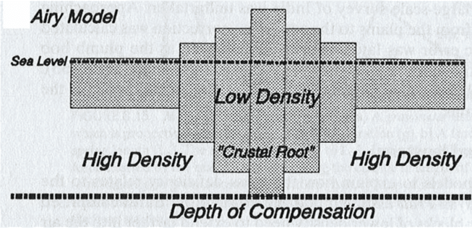
- The concept of Sir George Airy revolves around the idea that the Earth's crust is not hollow, but rather, the weight of the mountains is balanced by lighter materials below. According to Airy, the crust, made of lighter materials called "sial," floats on a denser substratum known as "sima." This means that massive mountain ranges like the Himalayas are floating on denser magma, similar to how a boat floats on water.
- Airy's concept is based on the principle of flotation, which states that the ratio of the part of an object floating above the water (freeboard) to the part submerged (draught) is 1 to 9. Applying this principle to the Earth's crust, it can be assumed that for every 1 part of the crust above the substratum, there are 9 parts submerged. For example, considering the Himalayas' height of 8,848 meters, there must be a downward projection of lighter material beneath the mountain reaching a depth of around 80,000 meters.
- However, another scientist named Joly suggested a different freeboard-to-draught ratio of 1 to 8, which would result in a depth of around 70,784 meters for the Himalayas. Despite the difference in ratios, both theories agree that a significant amount of lighter material must be submerged beneath the mountains to maintain their balance.
 Concept of Sir George
- According to Airy, the density of the Earth's crust remains the same regardless of the height of the landmass. This means that the continents are made of rocks with uniform density, but their thickness varies from place to place. To demonstrate this concept, Airy used iron pieces of different lengths, which submerged in mercury to varying depths depending on their lengths. This experiment can also be replicated using wooden pieces submerged in water.
- While Airy's concept is widely respected among the scientific community, it has some flaws. For instance, it is difficult to accept that the Himalayas have a downward projection of lighter material reaching depths of around 80,000 or 70,784 meters, as this would likely melt due to the high temperatures at such depths. Nevertheless, Airy's concept of isostasy remains an important contribution to the understanding of the Earth's crust and its underlying structure.
Concept of Archdeacon Pratt
- The concept of Archdeacon Pratt's isostasy was derived from his study of the difference in gravitational deflection during the geodetic survey of Kaliana and Kalianpur. He calculated the gravitational force of the Himalayas by taking the average density of the mountain range as 2.75 and found that the difference should have been 15.885 seconds. This led him to the conclusion that the horizontal plane between two sites must be askew, affecting the vertical direction as well.
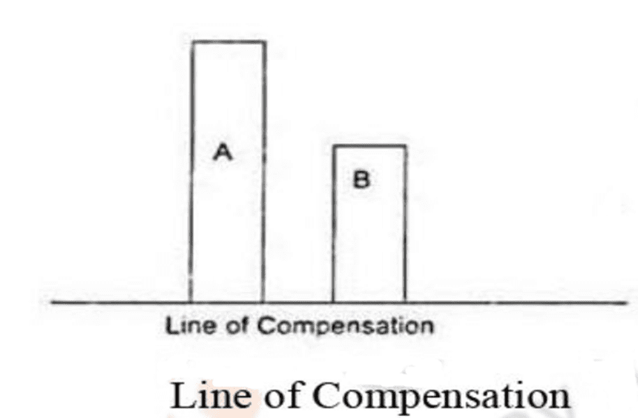
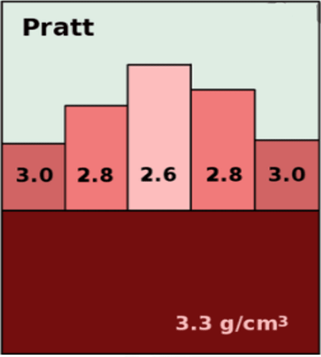
- Pratt further studied the rocks and their densities in the Himalayas and neighboring plains, discovering an inverse relationship between the height of the landforms and their density. In other words, the density of mountains is less than that of plateaus, which in turn is less than the density of plains and the ocean floor. According to Pratt, there is a level of compensation above which density varies among different land columns, but there is no change in density below this level. Within one column, density does not change, but it does vary between columns above the compensation level.
 Line of Compensation
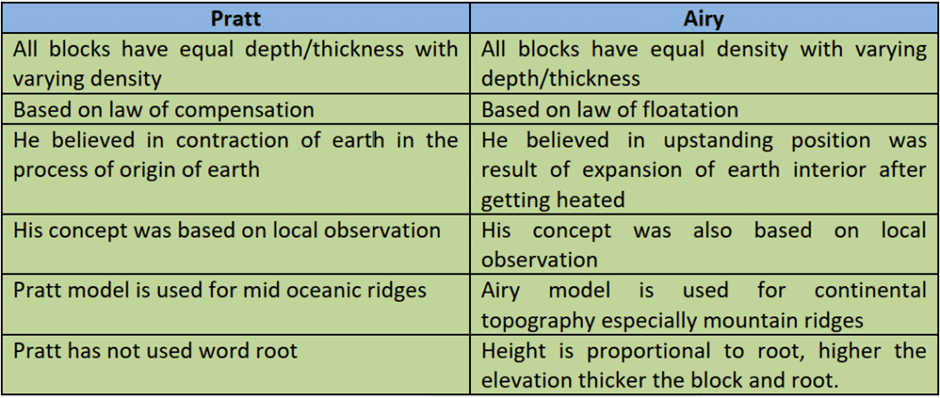
- Pratt's central theme on isostasy can be summarized as "uniform depth with varying density." He believed that along the line of compensation, equal surface areas must underlie equal mass. For example, if there are two columns (A and B) with equal surface areas but different heights, the density of column A should be less than that of column B in order to achieve equal weight along the line of compensation. This concept suggests that larger columns have lower density, while smaller columns have higher density.
- While Pratt's concept of isostasy does not directly align with the law of floatation or the idea of root formation, there are indirect implications of these principles in his work. Bowie has noted that a close examination of Pratt's concept reveals glimpses of both floatation and root formation.
- In comparing the views of Airy and Pratt on isostasy, Bowie observed that "the fundamental difference between Airy's and Pratt's views is that the former postulated a uniform density with varying thickness and the latter a uniform depth with varying density."
 Pratt’s Concept
Concept of Hayford and Bowie
- The concepts of isostasy proposed by Hayford and Bowie are quite similar to those of Pratt. According to Hayford and Bowie, there is a plane of compensation where the crustal parts are entirely balanced. The densities of these crustal parts vary with the elevations of columns above this compensation plane.
- In this concept, the density of mountains is lower than that of the ocean floor, meaning that the crust is made of lighter material under mountains than under the ocean floor. Additionally, there is a zone beneath the compensation plane where density remains uniform in a lateral direction.
- Hayford and Bowie propose that there is an inverse relationship between the height of crustal columns and their respective densities (as assumed by Pratt) above the compensation plane. The compensation plane, or level of compensation, is thought to be located at a depth of about 100 km. Columns with rocks of lower density stand higher than columns with rocks of higher density.
- To illustrate this concept, consider four imaginary columns (interior plain, plateau, coastal plain, and offshore region) reaching the level of compensation. Although their heights differ, they are balanced by their varying densities. The assumption is that the differing volume of matter in each column is compensated by its density so that they all exert equal downward pressure at the level of compensation and balance each other.
- This statement may be understood with the help of fig below:

- This concept can be visualized using a diagram showing different columns of equal cross-sections made from various metals and ores with varying densities floating in a basin of mercury. All of these columns reach the same line (level of compensation) and exert equal weight along that line.
- Bowie compared the views of Airy and Pratt on isostasy and found considerable similarity between them. However, he also noted that they were not identical. Bowie recognized elements of Airy's concept of root formation and the law of flotation in Pratt's views, albeit indirectly.
- However, the idea that crustal parts (various reliefs) are in the form of vertical columns, as proposed by Hayford and Bowie, is not entirely accurate because crustal features are typically found in horizontal layers.
Concept of Jolly
- Joly proposed his ideas on isostasy in 1925, challenging Hayford and Bowie's belief that there was a level of compensation at a depth of about 100 km beneath the Earth's surface. Joly argued that the high temperatures at this depth would lead to complete liquefaction, making it impossible for such a level of compensation to exist.
- Additionally, Joly disagreed with Hayford and Bowie's idea that the density above the level of compensation varied, while remaining uniform below it. He contended that this condition would be unstable, as geological events could easily disturb it and disrupt the level of compensation.
- Instead, Joly suggested that there was a zone of compensation, rather than a single level. He believed that below a shell of uniform density, there was a 10-mile (16 km) thick layer where the density varied. This concept implied that the compensation process was not a linear phenomenon, but rather a zonal one.
- Joly's ideas seemed to be more in line with the law of floatation, although he did not explicitly mention it. His concept was more similar to Airy's ideas than those of Hayford and Bowie. In Joly's model, areas of low density within the 10-mile layer corresponded to the downward projections of the lighter continental crust, while areas of high density represented the spaces filled with heavier underlying material.
Conclusion
The concept of isostasy has evolved through the contributions of various geologists, including Airy, Pratt, Hayford, Bowie, and Joly. These theories attempt to explain the balance between the Earth's large upstanding features and the underlying denser materials. Although their approaches differ, they all agree on the existence of a compensation mechanism that maintains this balance. Isostasy is an important concept in understanding the Earth's crust and its underlying structure, and has been instrumental in explaining phenomena such as glacial adjustment and gravitational deflection.Frequently Asked Questions (FAQs) of Isostasy
What is the main concept behind isostasy?
Isostasy refers to the state of balance that exists between the Earth's large upstanding features, such as mountain ranges and plateaus. It suggests that the Earth's lighter surface materials (sial) float on top of the denser magma (sima) found in the Earth's interior.
Who first proposed the concept of isostasy?
The concept of isostasy was first proposed by American geologist Clarence Dutton in 1889.
What are the key differences between the isostasy concepts proposed by Sir George Airy and Archdeacon Pratt?
Sir George Airy's concept of isostasy is based on the idea that the Earth's crust has a uniform density and varies in thickness, with lighter materials beneath mountain ranges balancing their weight. Archdeacon Pratt's concept, on the other hand, suggests that the crust maintains a uniform depth but varies in density, with larger columns having lower density and smaller columns having higher density.
What is the level or zone of compensation in the context of isostasy?
The level or zone of compensation refers to a specific depth or area within the Earth's crust where the crustal parts are entirely balanced. According to Hayford and Bowie, this level of compensation is located at a depth of about 100 km, while Joly suggests that it is a zone rather than a single level.
How does the concept of isostasy help explain the uplift of Scandinavian countries following the last ice age?
Isostasy can help explain the "glacial adjustment" observed in Scandinavian countries following the Pleistocene great ice age. The raised beaches of Finland, for example, demonstrate that an uplift of about 250 meters has occurred over the last 8,000 years due to isostatic adjustment.
|
303 videos|635 docs|252 tests
|
FAQs on Isostasy - Geography Optional for UPSC
| 1. What is the concept of isostasy? |  |
| 2. How does isostasy work? |  |
| 3. What are the factors that influence isostatic adjustments? |  |
| 4. How does isostasy contribute to the formation of mountains and valleys? |  |
| 5. What are the practical applications of isostasy in geology? |  |


