UPSC Exam > UPSC Notes > Geography for UPSC CSE > Map: Mountain Ranges in India
Map: Mountain Ranges in India | Geography for UPSC CSE PDF Download

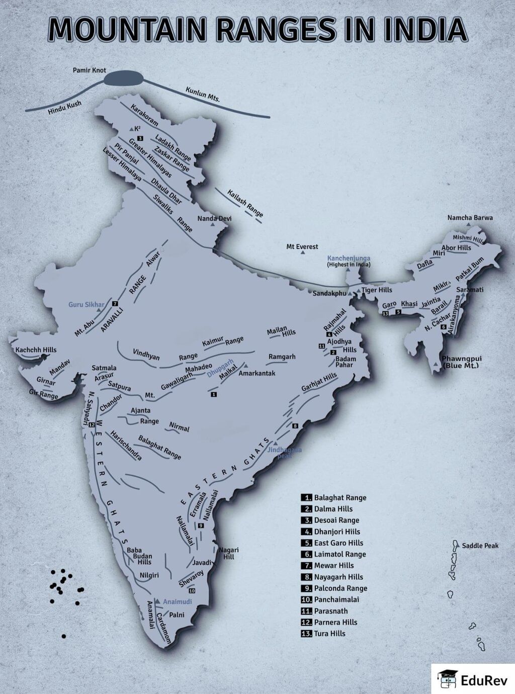
The document Map: Mountain Ranges in India | Geography for UPSC CSE is a part of the UPSC Course Geography for UPSC CSE.
All you need of UPSC at this link: UPSC
|
175 videos|624 docs|192 tests
|
FAQs on Map: Mountain Ranges in India - Geography for UPSC CSE
| 1. What are the major mountain ranges in India? |  |
Ans. The major mountain ranges in India include the Himalayas, the Western Ghats, the Eastern Ghats, the Aravalli Range, and the Vindhya Range. The Himalayas are the highest and most prominent, forming a natural barrier between India and Tibet, while the Western and Eastern Ghats are significant for biodiversity and climate regulation.
| 2. How do the Himalayas influence the climate of India? | |
Ans. The Himalayas play a crucial role in influencing the climate of India by acting as a barrier to cold winds from Central Asia. They also block the southwest monsoon winds, causing heavy rainfall on the southern slopes and creating a rain shadow effect in the northern regions. This results in diverse climatic conditions across the country.
| 3. What is the significance of the Western Ghats in terms of biodiversity? | |
Ans. The Western Ghats are recognized as one of the world's eight "hottest hotspots" of biological diversity. They are home to numerous endemic species of flora and fauna, including many threatened species. The range also plays a vital role in the hydrology of the region, influencing the water supply for millions.
| 4. What geological processes led to the formation of the Himalayan mountain range? | |
Ans. The Himalayan mountain range was formed due to the collision of the Indian Plate with the Eurasian Plate, a process that began around 50 million years ago. This tectonic activity caused the uplift of the land, leading to the creation of the tallest peaks in the world, including Mount Everest.
| 5. What are the key features of the Aravalli Range? | |
Ans. The Aravalli Range is one of the oldest mountain ranges in India, characterized by its rugged terrain and rich mineral resources. It runs approximately 800 kilometers from the northeast to the southwest of India, passing through states like Rajasthan, Haryana, and Gujarat. The range influences local climate and is home to several wildlife sanctuaries.
About this Document

4.94/5
Rating

Sep 21, 2025
Last updated
Related Exams
Document Description: Map: Mountain Ranges in India for UPSC 2025 is part of Geography for UPSC CSE preparation.
The notes and questions for Map: Mountain Ranges in India have been prepared according to the UPSC exam syllabus. Information about Map: Mountain Ranges in India covers topics
like and Map: Mountain Ranges in India Example, for UPSC 2025 Exam. Find important definitions, questions, notes, meanings, examples, exercises and tests below for Map: Mountain Ranges in India.
Introduction of Map: Mountain Ranges in India in English is available as part of our Geography for UPSC CSE
for UPSC & Map: Mountain Ranges in India in Hindi for Geography for UPSC CSE course.
Download more important topics related with notes, lectures and mock test series for UPSC
Exam by signing up for free. UPSC: Map: Mountain Ranges in India | Geography for UPSC CSE
Description
Full syllabus notes, lecture & questions for Map: Mountain Ranges in India | Geography for UPSC CSE - UPSC | Plus excerises question with solution to help you revise complete syllabus for Geography for UPSC CSE | Best notes, free PDF download
Information about Map: Mountain Ranges in India
In this doc you can find the meaning of Map: Mountain Ranges in India defined & explained in the simplest way possible. Besides explaining types of
Map: Mountain Ranges in India theory, EduRev gives you an ample number of questions to practice Map: Mountain Ranges in India tests, examples and also practice UPSC
tests

Related Searches
video lectures
,Semester Notes
,practice quizzes
,Free
,Map: Mountain Ranges in India | Geography for UPSC CSE
,Extra Questions
,MCQs
,mock tests for examination
,Summary
,study material
,Map: Mountain Ranges in India | Geography for UPSC CSE
,ppt
,Previous Year Questions with Solutions
,past year papers
,Exam
,Map: Mountain Ranges in India | Geography for UPSC CSE
,Objective type Questions
,shortcuts and tricks
,Sample Paper
,Important questions
,Viva Questions
;


Additional Information about Map: Mountain Ranges in India for UPSC Preparation
Map: Mountain Ranges in India Free PDF Download
The Map: Mountain Ranges in India is an invaluable resource that delves deep into the core of the UPSC exam.
These study notes are curated by experts and cover all the essential topics and concepts, making your preparation more efficient and effective.
With the help of these notes, you can grasp complex subjects quickly, revise important points easily,
and reinforce your understanding of key concepts. The study notes are presented in a concise and easy-to-understand manner,
allowing you to optimize your learning process. Whether you're looking for best-recommended books, sample papers, study material,
or toppers' notes, this PDF has got you covered. Download the Map: Mountain Ranges in India now and kickstart your journey towards success in the UPSC exam.
Importance of Map: Mountain Ranges in India
The importance of Map: Mountain Ranges in India cannot be overstated, especially for UPSC aspirants.
This document holds the key to success in the UPSC exam.
It offers a detailed understanding of the concept, providing invaluable insights into the topic.
By knowing the concepts well in advance, students can plan their preparation effectively.
Utilize this indispensable guide for a well-rounded preparation and achieve your desired results.
Map: Mountain Ranges in India Notes
Map: Mountain Ranges in India Notes offer in-depth insights into the specific topic to help you master it with ease.
This comprehensive document covers all aspects related to Map: Mountain Ranges in India.
It includes detailed information about the exam syllabus, recommended books, and study materials for a well-rounded preparation.
Practice papers and question papers enable you to assess your progress effectively.
Additionally, the paper analysis provides valuable tips for tackling the exam strategically.
Access to Toppers' notes gives you an edge in understanding complex concepts.
Whether you're a beginner or aiming for advanced proficiency, Map: Mountain Ranges in India Notes on EduRev are your ultimate resource for success.
Map: Mountain Ranges in India UPSC Questions
The "Map: Mountain Ranges in India UPSC Questions" guide is a valuable resource for all aspiring students preparing for the
UPSC exam. It focuses on providing a wide range of practice questions to help students gauge
their understanding of the exam topics. These questions cover the entire syllabus, ensuring comprehensive preparation.
The guide includes previous years' question papers for students to familiarize themselves with the exam's format and difficulty level.
Additionally, it offers subject-specific question banks, allowing students to focus on weak areas and improve their performance.
Study Map: Mountain Ranges in India on the App
Students of UPSC can study Map: Mountain Ranges in India alongwith tests & analysis from the EduRev app,
which will help them while preparing for their exam. Apart from the Map: Mountain Ranges in India,
students can also utilize the EduRev App for other study materials such as previous year question papers, syllabus, important questions, etc.
The EduRev App will make your learning easier as you can access it from anywhere you want.
The content of Map: Mountain Ranges in India is prepared as per the latest UPSC syllabus.
|
© EduRev
|
Education Revolution
|


|


Signup on EduRev and stay on top of your study goals
10M+ students crushing their study goals daily