NCERT Summary: Drainage System - 2 | Geography for UPSC CSE PDF Download
➢
The Brahmaputra System
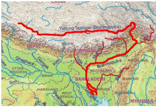
The Brahmaputra, one of the largest rivers of the world, has its origin in the Chemayungdung glacier of the Kailash range near the Mansarovar lake. From here, it traverses eastward longitudinally for a distance of nearly 1,200 km in a dry and flat region of southern Tibet, where it is known as the Tsangpo, which means ‘the purifier’.
 Brahmaputra River System
- The Rango Tsangpo is the major right-bank tributary of this river in Tibet. It emerges as a turbulent and dynamic river after carving out a deep gorge in the Central Himalayas near Namcha Barwa (7,755 m). The river emerges from the foothills under the name of Siang or Dihang. It enters India west of Sadiya town in Arunachal Pradesh. Flowing southwest, it receives its main left-bank tributaries, viz., Dibang or Sikang and Lohit, thereafter, it is known as the Brahmaputra.
- The Brahmaputra receives numerous tributaries in its 750 km long journey through the Assam valley. Its major left bank tributaries are the Burhi Dihing, Dhansari (South) and Kalang whereas the important right bank tributaries are the Subansiri, Kameng, Manas and Santosh. The Subansiri which has its origin in Tibet is an antecedent river. The Brahmaputra enters into Bangladesh near Dhubri and flows southward.
- In Bangladesh, the Tista joins it on its right bank from where the river is known as the Yamuna. It finally merges with the river Padma, which falls in the Bay of Bengal. The Brahmaputra is well-known for floods, channel shifting and bank erosion. This is due to the fact that most of its tributaries are large, and bring large quantity of sediments owing to heavy rainfall in its catchment area.
The Peninsular Drainage System
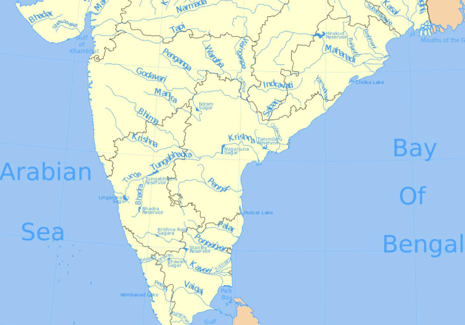
- The peninsular drainage system is older than the Himalayan one. This is evident from the broad, largely-graded shallow valleys, and the maturity of the rivers. The Western Ghats running close to the western coast act as the water divide between the major peninsular rivers, discharging their water in the Bay of Bengal and as small rivulets joining the Arabian Sea. Most of the major peninsular rivers except Narmada and Tapi flow from west to east.
- The Chambal, the Sind, the Betwa, the Ken, the Son, originating in the northern part of the peninsular belong to the Ganga river system. The other major river systems of the peninsular drainage are the Mahanadi, the Godavari, the Krishna and the Kaveri.
- Peninsular rivers are characterized by fixed course, absence of meanders and no perennial flow of water. The Narmada and the Tapi which flow through the rift valley are, however, exceptions. They meet in the Arabian sea.
➢ The Evolution of Peninsular Drainage System
Three major geological events in the distant past have shaped the present drainage systems of peninsular India:
- Subsidence of the western flank of the peninsula leading to its submergence below the sea during the early tertiary period. Generally, it has disturbed the symmetrical plan of the river on either side of the original watershed.
- The upheaval of the Himalayas when the northern flank of the peninsular block was subjected to subsidence and the consequent trough faulting. The Narmada and the Tapi flow in trough faults and fill the original cracks with their detritus materials. Hence, there is a lack of alluvial and deltaic deposits in these rivers.
- Slight tilting of the peninsular block from northwest to the southeastern direction gave orientation to the entire drainage system towards the Bay of Bengal during the same period.
➢ River Systems of the Peninsular Drainage
There are a large number of river systems in the peninsular drainage.
A brief account of the major peninsular river systems is given below:
 Peninsular Drainage System
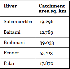
- The Mahanadi rises near Sihawa in the Raipur district of Chhattisgarh and runs through Orissa to discharge its water into the Bay of Bengal. It is 851 km long and its catchment area spreads over 1.42 lakhs sq. km. Some navigation is carried on in the lower course of this river. Fifty-three percent of the drainage basin of these rivers lies in Madhya Pradesh and Chhattisgarh, while 47 percent lies in Orissa.
- The Godavari is the largest peninsular river system. It is also called the Dakshin Ganga. It rises in the Nasik district of Maharashtra and discharges its water into the Bay of Bengal. Its tributaries run through the states of Maharashtra, Madhya Pradesh, Chhattisgarh, Orissa, and Andhra Pradesh. It is 1,465 km long with a catchment area spreading over 3.13 lakh sq. km 49 percent of this, lies in Maharashtra, 20 percent in Madhya Pradesh and Chhattisgarh, and the rest in Andhra Pradesh.
- The Penganga, the Indravati, the Pranhita, and the Manjra are its principal tributaries. The Godavari is subjected to heavy floods in its lower reaches to the south of Polavaram, where it forms a picturesque gorge. It is navigable only in the deltaic stretch. The river after Rajahmundry splits into several branches forming a large delta.
- The Krishna is the second-largest east-flowing peninsular river which rises near Mahabaleshwar in Sahyadri. Its total length is 1,401 km. The Koyna, the Tungabhadra, and the Bhima are its major tributaries. Of the total catchment area of the Krishna, 27 percent lies in Maharashtra, 44 percent in Karnataka, and 29 percent in Andhra Pradesh.
- The Kaveri rises in Brahmagiri hills 1,341m of Kodagu district in Karnataka. Its length is 800 km and it drains an area of 81,155 sq. km. Since the upper catchment area receives rainfall during the southwest monsoon season (summer) and the lower part during the northeast monsoon season (winter), the river carries water throughout the year with comparatively less fluctuation than the other peninsular rivers. About 3 percent of the Kaveri basin falls in Kerala, 41 percent in Karnataka, and 56 percent in Tamil Nadu. Its important tributaries are the Kabini, the Bhavani, and the Amravati.
- The Narmada originates on the western flank of the Amarkantak plateau at a height of about 1,057 m. Flowing in a rift valley between the Satpura in the south and the Vindhya range in the north. It forms a picturesque gorge in marble rocks and Dhuandhar waterfall near Jabalpur. After flowing a distance of about 1,312 km, it meets the Arabian sea south of Bharuch, forming a broad 27 km long estuary. Its catchment area is about 98,796 sq. km. The Sardar Sarovar Project has been constructed on this river.
- The Tapi is the other important westward flowing river. It originates from Multai in the Betul district of Madhya Pradesh. It is 724 km long and drains an area of 65,145 sq. km. Nearly 79 percent of its basin lies in Maharashtra, 15 percent in Madhya Pradesh, and the remaining 6 percent in Gujarat.
- Luni is the largest river system of Rajasthan, west of Aravali. It originates near Pushkar in two branches. i.e. the Saraswati and the Sabarmati, which join with each other at Govindgarh. From here, the river comes out of Aravali and is known as Luni. It flows towards the west till Tilwara and then takes a southwest direction to join the Rann of Kachchh. The entire river system is ephemeral.

➢ Smaller Rivers Flowing Towards the West
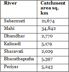
- The rivers flowing towards the Arabian sea have short courses. Find out the smaller rivers of Gujarat. The Shetruniji is one such river which rises near Dalkahwa in Amreli district. The Bhadra, originates near Aniali village in Rajkot district. The Dhadhar rises near Ghantar village in Panchmahal district. Sabarmati and Mahi are the two famous rivers of Gujarat.
- The Vaitarna rises from the Trimbak hills in Nasik district at an elevation of 670 m. The Kalinadi rises from Belgaum district and falls in the Karwar Bay. The source of Bedti river lies in Hubli Dharwar and traverses a course of 161 km. The Sharavati is another important river in Karnataka flowing towards the west. The Sharavati originates in Shimoga district of Karnataka and drains a catchment area of 2,209 sq. km. Goa has two important rivers which can be mentioned here. One is Mandovi and the other is Juari.

- Kerala has a narrow coastline. The longest river of Kerala, Bharathapuzha rises near Annamalai hills. It is also known as Ponnani. It drains an area of 5,397 sq. km Compare its catchment area with that of the Sharavathi river of Karnataka.
- The Periyar is the second largest river of Kerala. Its catchment area is 5,243 sq. km. You can see that there is a marginal difference in the catchment area of the Bharathapuzha and the Periyar rivers.
- Another river of Kerala worth mentioning is the Pamba river which falls in the Vembanad lake after traversing a course of 177 km.
|
263 videos|872 docs|232 tests
|
FAQs on NCERT Summary: Drainage System - 2 - Geography for UPSC CSE
| 1. What is the Peninsular Drainage System? |  |
| 2. How does the Peninsular Drainage System differ from the Himalayan Drainage System? |  |
| 3. What are the major rivers in the Peninsular Drainage System? |  |
| 4. How does the Peninsular Drainage System contribute to the economy of India? |  |
| 5. What are the characteristics of the drainage pattern in the Peninsular Drainage System? |  |


