NCERT Summary: Natural Hazards and Disasters | Geography for UPSC CSE PDF Download
What is Disaster?
- Disaster is an event that occurs due to forces largely beyond human control, striking suddenly with little or no warning. It leads to significant disruption of life and property, including death and injury to a large number of people. Such events require efforts exceeding those typically provided by emergency services.
- Historically, disasters were attributed to natural forces, portraying humans as innocent victims helpless against nature's power. However, human activities can also contribute to disasters, not just natural forces.
- Examples of human activities intensifying disasters indirectly include landslides and floods resulting from deforestation.
- The key approach lies in focusing on mitigating and managing natural disasters effectively.
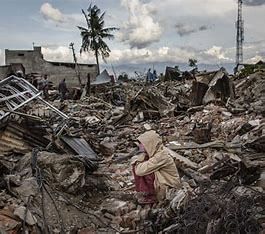
Difference between Disaster and Natural Hazard
- Natural hazards are aspects of the environment that can cause harm to people or property. These hazards may be inherent characteristics of the environment, such as ocean currents.
- In contrast, disasters, whether caused by natural forces or human activities, are sudden events resulting in widespread death, property loss, and societal disruption.
- Natural hazards can either be immediate or enduring features of the environment, such as ocean currents, steep slopes, unstable structures in mountainous regions like the Himalayas, or extreme weather conditions in deserts and glaciated areas.
- Any incident transforms into a disaster when it inflicts significant destruction and harm. Each disaster is distinct based on local socio-economic influences, the social reactions it provokes, and how different societal groups cope with it.
Facts about Disasters
- The intensity, frequency, and impact of natural disasters have escalated over time.
- There is a global apprehension regarding addressing the threats posed by these disasters to minimize human and property losses.
- Notable transformations have occurred in the patterns of natural disasters in recent years.
Modern Perceptions of Natural Hazards and Disasters
- There has been a shift in the understanding of natural hazards and disasters.
- Previously, hazards and disasters were viewed as closely linked phenomena. Regions prone to natural hazards were at higher risk of disasters. Consequently, people refrained from intensifying activities in such areas, resulting in less severe disasters.
- The advancement of technology has empowered humans to manipulate nature to a significant extent.
- As a result, individuals now tend to increase their activities in disaster-prone zones, heightening their susceptibility to disasters.
Yokohama Strategy and Plan of Action for a Safer World
- All the member states of the United Nations and other states convened at the World Conference on Natural Disaster Reduction in Yokohama from May 23rd-27th, 1994.
- The resolution of the conference includes the following key points:
- Recognition of each country's duty to safeguard its citizens from natural disasters.
- Special focus on developing nations, especially the least developed, land-locked countries, and small island developing states.
- Enhancement of national capacities and legislation for disaster prevention, mitigation, and preparedness, involving NGOs and local communities.
- Promotion of sub-regional, regional, and international collaboration for disaster prevention and mitigation, emphasizing capacity building, technology sharing, and resource mobilization.
- The decade 1990-2000 was designated as the International Decade for Natural Disaster.

Natural Disasters And Hazards In India
Earthquakes
- Earthquakes are the most unpredictable and highly destructive natural disasters.
- Tectonically triggered earthquakes are particularly devastating with a wide-ranging impact.
Causes of Earthquakes
- Earthquakes occur due to sudden energy release during tectonic activities in the earth's crust.
Comparison with Other Types of Earthquakes
- Earthquakes associated with volcanic eruptions, rock falls, landslides, and other factors have limited impact compared to tectonic earthquakes.
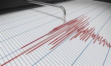
Plate Movements
- The Indian plate moves about one centimeter per year towards the north and northeast, facing obstruction from the Eurasian plate.
- This leads to the accumulation of energy between the plates over time.
- Excess energy buildup causes stress, eventually resulting in earthquakes along the Himalayan region.
Vulnerable Regions
- States like Jammu and Kashmir, Himachal Pradesh, Uttarakhand, Sikkim, Darjiling, and the northeastern states are highly vulnerable to earthquakes.
Earthquake Risk Zones
- National organizations like the National Geophysical Laboratory and Geological Survey of India categorize earthquake risk into five zones:
- Very high damage risk zone
- High damage risk zone
- Moderate damage risk zone
- Low damage risk zone
- Very low damage risk zone
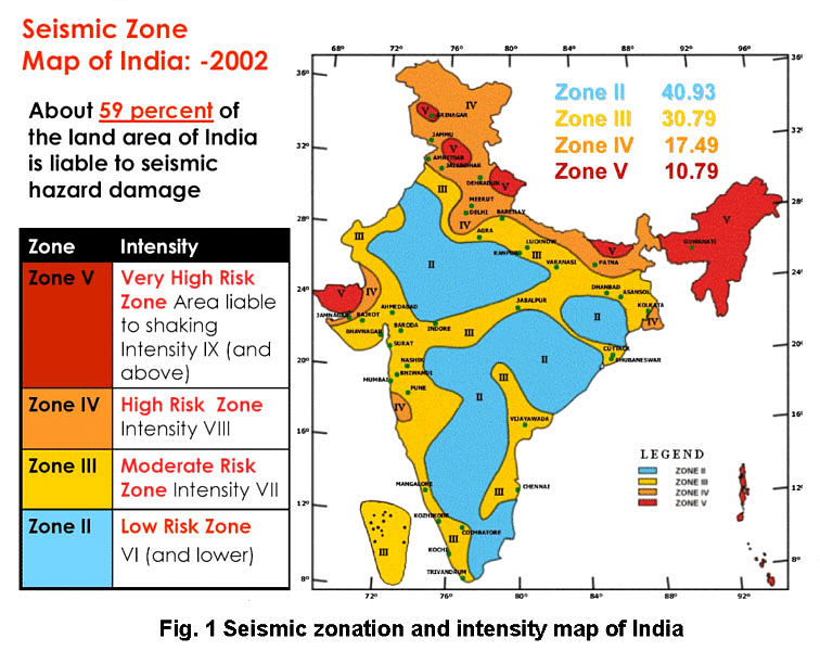
- North-east states, areas to the north of Darbhanga and Araria along the Indo-Nepal border in Bihar, Uttarakhand, Western Himachal Pradesh (around Dharamshala) are in the Very high damage risk zone.
- The remaining parts of Jammu and Kashmir, Himachal Pradesh, Northern parts of Punjab, Eastern parts of Haryana, Delhi, Western Uttar Pradesh, and Northern Bihar fall under the High Damage Risk Zone.
- Remaining parts of the country fall under moderate to very Low Damage Risk Zone. Most of the areas that can be considered safe are from the stable landmass covered under the Deccan plateau.
Socio-Environmental Consequences of Earthquakes
- When earthquakes strike areas of high population density, they become calamities.
- Earthquakes not only damage settlements, infrastructure, transport, communication networks, industries, and other developmental activities but also deprive the population of their material and socio-cultural gains accumulated over generations.
- Earthquakes render people homeless, imposing additional pressure and stress, especially on the weak economies of developing countries.
Effects of Earthquakes
On Ground
- Fissures
- Cracking
- Waves
- Settlements Slidings
- Hydro-Dynamic Landslides
- Overturing Pressure
- Liquefaction
- Buckling
- Tsunami
- Earth Pressure Collapse
- Possible Chain-effects
On Manmade Structures
- Possible Chain-effects
- Possible Chain-effects
- Possible Chain-effects
On Water
- Apart from these, earthquakes also have some serious and far-reaching environmental consequences.
- Earthquakes are responsible for landslides, which can obstruct the formation of reservoirs.
Earthquake Hazard Mitigation
- Establishing earthquake monitoring centres (seismological centres) for regular monitoring and fast dissemination of information among the people in the vulnerable areas. The utilization of the Geographical Positioning System (GPS) can greatly aid in monitoring the movement of tectonic plates.
- Preparing a vulnerability map of the country and sharing vulnerability risk information among the population, educating them on ways to minimize the adverse impacts of disasters.
- Adapting house types and building designs in vulnerable areas, while discouraging the construction of high-rise buildings, large industrial establishments, and major urban centers in such locations.
- Making it obligatory to implement earthquake-resistant designs and utilize lightweight materials in significant construction projects within vulnerable areas.
Tsunami
- A tsunami is a sequence of waves triggered by events like earthquakes, underwater volcanic eruptions, landslides, or sudden disturbances.
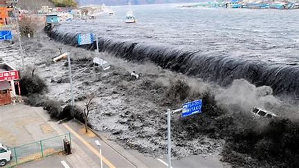
- The primary cause of a tsunami is an earthquake, characterized by the abrupt shifting of the earth's crust, releasing significant energy.
- A tsunami can move as swiftly as a jet plane when in deep ocean waters.
Formation of Tsunami
- A tsunami comprises waves generated in oceans or other water bodies due to disturbances like earthquakes, landslides, volcanic eruptions, or meteorite impacts.
- Undersea earthquakes, typically occurring at Earth's tectonic plate boundaries, displace the water above either upwards or downwards.
Regions Affected by Tsunami
- Tsunamis are commonly found along the Pacific Ring of Fire, notably affecting regions such as the coasts of Alaska, Japan, the Philippines, and various islands of Southeast Asia.
- Other impacted areas include Indonesia, Malaysia, Myanmar, Sri Lanka, and India, among others.
Effects of Tsunami
- Upon reaching the shore, tsunami waves unleash significant stored energy, leading to turbulent water flow onto land.
- This turbulent flow results in the destruction of port cities, towns, structures, buildings, and other settlements.
- The impact of tsunamis is particularly severe along coastlines due to high population density in these areas.
Mitigation
- Addressing tsunami damage surpasses the capabilities of individual states or governments.
- International collaborative efforts are crucial in managing these disasters, as exemplified by the 2004 tsunami that claimed over 300,000 lives.
- India, for instance, has offered support by participating in the International Tsunami Warning System following the 2004 catastrophe.
Tropical Cyclone
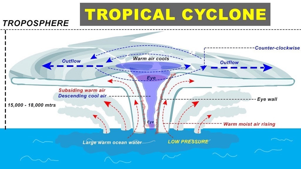
- Tropical cyclones are intense low-pressure systems occurring within the region between 30° N and 30° S latitudes.
- These cyclones are characterized by high-velocity winds circulating around a central area of low pressure.
- Horizontally, tropical cyclones can extend from 500 to 1,000 km, with vertical reach from the surface up to 12-14 km.
- Functioning as heat engines, tropical cyclones derive energy from the release of latent heat due to moisture condensation gathered as winds traverse oceans and seas.
Initial Conditions for Tropical Cyclone Formation
- An essential prerequisite is a continuous supply of warm, moist air capable of releasing significant latent heat.
Key Concepts of Tropical Cyclones
- Strong Coriolis force plays a crucial role in preventing the filling of low pressure at the center. The absence of the Coriolis force near the equator hinders the formation of tropical cyclones between 0°-5° latitude.
- An unstable condition throughout the troposphere leads to the development of local disturbances, which serve as the focal points around which a cyclone evolves.
- The absence of a strong vertical wind wedge disrupts the vertical transport of latent heat, contributing to the cyclone's development.
Structure of Tropical Cyclones
- Tropical cyclones are characterized by large pressure gradients. The core of the cyclone typically consists of a warm, low-pressure, cloudless center known as the eye of the storm.
- Isobars in tropical cyclones are closely spaced, indicating high-pressure gradients. Normally ranging between 14-17mb/100 km, these gradients can occasionally reach values as high as 60mb/100km.
- The wind belt in a tropical cyclone typically extends around 10-150 km from the center.
Spatio-temporal Distribution of Tropical Cyclones in India
- Tropical cyclones in India typically originate in the Arabian Sea to the west and the Bay of Bengal to the east.
- While most cyclones originate between 10°-15° north latitudes during the monsoon season, those forming in the Bay of Bengal predominantly develop during October and November. These cyclones originate between 16°-20° N latitudes and west of 92° E.
- By July, the genesis of these storms shifts to around 18° N latitude and west of 90° E, near the Sunderban Delta region.
Consequences of Tropical Cyclones
- The energy driving tropical cyclones comes from the latent heat released by warm, moist air.
Natural Disasters: Cyclones and Floods
Cyclones
- As one moves away from the sea, the intensity of cyclones diminishes.
- In India, cyclone strength decreases as the distance from the Bay of Bengal and the Arabian Sea increases. This results in coastal areas frequently experiencing severe cyclonic storms with wind speeds averaging 180 km/h.
- Tropical cyclones can lead to a significant rise in sea levels, a phenomenon known as a Storm Surge. The surge occurs due to the interplay of air, sea, and land.
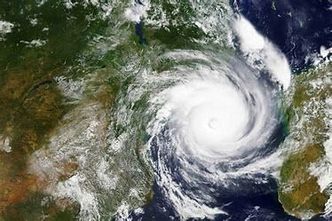
- Cyclones exert a driving force through high horizontal pressure gradients and strong surface winds.
- The combination of strong winds and heavy rainfall causes seawater to inundate coastal areas, resulting in damage to human settlements, agricultural lands, crops, and structures.
Floods
- Floods commonly arise when surface runoff exceeds the capacity of river channels, leading water into adjacent low-lying floodplains.
- Floods occur when rivers overflow their banks, inundating the surrounding floodplains.
- Heavy rainfall is a primary cause of flooding. The faster rainwater reaches river channels, the higher the likelihood of flooding.
- Regions like South, Southeast, and East Asian countries, including China, India, and Bangladesh, frequently experience devastating floods.
Areas of India Prone to Floods
- The National Flood Commission identified 40 million hectares of land in India as flood-prone.
Flood-Prone States in India
- Assam, West Bengal, and Bihar are states highly susceptible to flooding.
- Northern states like Punjab and Uttar Pradesh also face occasional flood risks.
- Rajasthan, Gujarat, Haryana, and Punjab have witnessed increased flash floods in recent decades.
- Tamil Nadu experiences flooding from November to January due to the retreating monsoon.
Consequences of Floods
- Flooding has significant negative impacts on the national economy and society.
- Valuable crops are destroyed annually due to floods.
- Physical infrastructure like roads, railways, bridges, and human settlements suffer damage.
- Millions of people are displaced, with some losing their lives and livestock in the floods.
- Diseases such as cholera, gastro-enteritis, and hepatitis spread rapidly in flood-affected regions.
- One positive outcome of flooding is the deposition of fertile silt beneficial for crops. An example is Majuli in Assam, known for good paddy crops after annual Brahmaputra floods.
Methods to Control Floods
- Rivers prone to flooding are often managed carefully in many countries.
Defences against Natural Disasters
- Levees, bunds, reservoirs, and weirs are utilized to prevent rivers from overflowing their banks.
- In cases of defence failure, emergency measures like sandbags or portable inflatable tubes are employed.
- Coastal regions combat flooding through structures such as sea walls, beach nourishment, and barrier islands.
- A dike is a flood protection method that reduces flood risk and minimizes damage. However, combining dikes with other control techniques is recommended to prevent dike failures.
- Weirs, also known as lowhead dams, are commonly used to create millponds. An example includes the weir constructed on the Humber River near Raymore Drive in Toronto to prevent a recurrence of the devastating flooding caused by Hurricane Hazel in 1954.
Droughts: Causes and Types
- The term 'drought' signifies an extended period characterized by water scarcity due to insufficient precipitation, excessive evaporation rates, and overuse of water resources.
- Drought is a multifaceted phenomenon involving meteorological elements such as precipitation, evaporation, evapotranspiration, groundwater, soil moisture, water storage, surface run-off, agricultural practices, socio-economic factors, and ecological conditions.
Types of Droughts
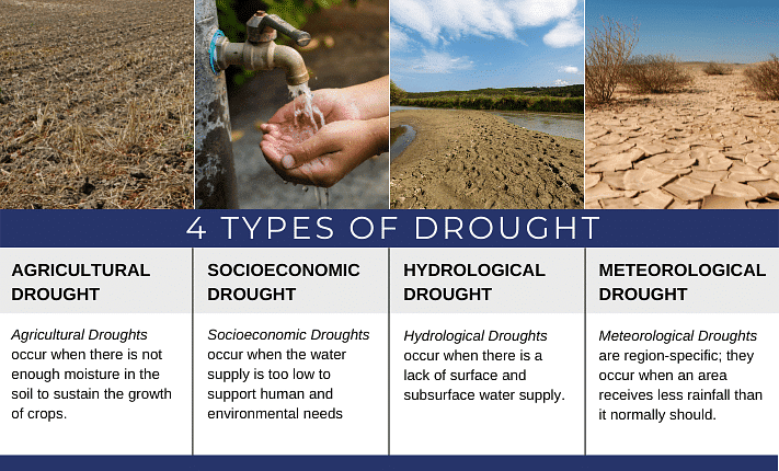
- Meteorological Drought: This occurs during an extended period of inadequate rainfall, often accompanied by uneven distribution over time and space.
- Agricultural Drought: This type, also known as soil moisture drought, occurs when there is insufficient soil moisture to support crop growth, leading to crop failures. Areas with over 30% of their gross cropped area under irrigation are not considered drought-prone.
- Hydrological Drought: This type arises when water availability in various storage systems like aquifers, lakes, and reservoirs falls below the level that precipitation can replenish.
- Ecological Drought: This type occurs when water scarcity causes the productivity of natural ecosystems to decline, resulting in ecological distress and damage to the ecosystem.
Drought Scenario in India
- Droughts and floods are two prevalent climatic features in India.
- Approximately 19% of India's total geographical area and 12% of its population face drought conditions annually.
- 30% of the country's land is identified as drought-prone, affecting around 50 million people.
- India experiences a phenomenon where some regions face floods while others suffer from severe drought simultaneously.
- It is common for a region to encounter floods in one season and drought in another due to the erratic behavior of the monsoon in India.
Drought Severity in India
- Extreme Drought Affected Area: This region encompasses most parts of Rajasthan, particularly the areas to the west of the Aravali hills.
Drought Classification in India
- Severe Drought Prone Area: This category encompasses parts of eastern Rajasthan, most parts of Madhya Pradesh, eastern parts of Maharashtra, interior parts of Andhra Pradesh, Karnataka Plateau, northern parts of interior Tamil Nadu, and southern parts of Jharkhand and interior Orissa.
- Moderate Drought Affected Area: This classification includes northern parts of Rajasthan, Haryana, southern districts of Uttar Pradesh, the remaining parts of Gujarat, Maharashtra excluding Konkan, Jharkhand, Coimbatore plateau of Tamil Nadu, and interior Karnataka.
- The remaining parts of India can be considered either free from drought or less prone to it.
Consequences of Drought
- Impact on Agriculture: Droughts result in crop failures leading to scarcity of food grains and fodder. For example, inadequate rainfall causes water scarcity, which is extremely devastating when there's a shortage of food grains, fodder, and water simultaneously.
- Livestock Loss: Large-scale deaths of cattle and other animals occur during droughts, impacting the livelihoods of farmers who depend on them.
- Human Migration: Drought-stricken areas often witness migrations of both humans and livestock in search of food and water resources.
- Waterborne Diseases: Scarcity of clean water forces people to consume contaminated water, leading to the spread of waterborne diseases like gastro-enteritis, cholera, and hepatitis.
- Mitigation
- Provision for the distribution of safe drinking water
- Supplying medicines for the victims
- Ensuring availability of fodder and water for the cattle
- Relocating people and their livestock to safer places
- Identifying groundwater potential through aquifers
- Transferring river water from surplus to deficit areas
- Planning for inter-linking of rivers
- Constructing reservoirs and dams
- Utilizing remote sensing and satellite imagery for identifying potential river basins and groundwater sources
- Disseminating knowledge about drought-resistant crops and providing training for their cultivation
- Implementing rainwater harvesting to minimize drought effects
- Landslides
- Landslides are influenced by highly localized factors, making it challenging and costly to gather information and monitor landslide possibilities
- It is complex to precisely define and generalize the occurrence and behavior of landslides
- Controlling Factors
- Geology
- Geomorphic agents
- Slope
- Land-use
- Vegetation cover
- Human activities
- Landslide Vulnerability Zones of India
- Very High Vulnerability Zone:
- Includes highly unstable, relatively young mountainous areas in the Himalayas and Andaman and Nicobar
- Encompasses high rainfall regions with steep slopes in the Western Ghats and Nilgiris
- Incorporates the north-eastern regions and areas prone to frequent ground-shaking due to earthquakes
- Very High Vulnerability Zone:
Types of Vulnerability Zones to Landslides in India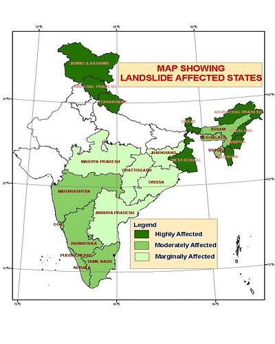
- Very High Vulnerability Zone:
- Areas characterized by intense human activities like construction of roads, dams, etc.
- High Vulnerability Zone:
- Includes areas with conditions similar to the very high vulnerability zone.
- Distinct by the combination, intensity, and frequency of controlling factors.
- States in the Himalayan region and northeastern states, excluding the plains of Assam, fall under this category.
- Moderate to Low Vulnerability Zone:
- Areas with low precipitation levels such as Trans-Himalayan regions of Ladakh and Spiti.
- Regions with undulated yet stable relief and low precipitation like parts of the Aravali range.
- Occasional landslides occur in rain shadow areas of the Western and Eastern Ghats and the Deccan plateau.
- States like Jharkhand, Orissa, Chhattisgarh, Madhya Pradesh, Maharashtra, Andhra Pradesh, Karnataka, Tamil Nadu, Goa, and Kerala experience landslides due to mining and subsidence.
- Other Areas:
- Includes states such as Rajasthan, Haryana, Uttar Pradesh, Bihar, West Bengal (excluding Darjeeling district), Assam (excluding Karbi Anglong district), and coastal regions of southern states.
- Considered safe from landslides compared to more vulnerable zones.
Consequences of Landslides
- Roadblock
- Destruction of railway lines
- Channel-blocking due to rock-falls with widespread impact
- Diversion of river courses leading to potential floods
- Loss of life and property
- Disruption of spatial interaction affecting developmental activities
Mitigation
- Restriction on construction and other developmental activities like roads and dams.
- Limiting agriculture to valleys and areas with moderate slopes.
- Control on the development of large settlements in high vulnerability zones.
- Promoting large-scale afforestation programs.
- Construction of bunds to reduce the flow of water.
- Terrace farming promotion in northeastern hill states where Jhumming is prevalent.
Disaster Management
- Refers to the protection and preservation of lives and property.
- India is uniquely vulnerable to natural disasters due to its geo-climatic conditions.
- Floods, droughts, cyclones, earthquakes, and landslides are recurrent in India.
Steps to Minimize Cyclone Damages
- Construction of cyclone shelters, embankments, dykes, and reservoirs.
- Afforestation to reduce wind speed.
- Implementation of The Disaster Management Bill, 2005.
Conclusion
Mitigation and Preparedness involve three stages in disaster management:
- Pre-disaster management:
- Generating data and information about disasters.
- Preparing vulnerability zoning maps.
- Spreading awareness about disasters.
- Disaster planning and preparedness measures.
- During disasters:
- Rescue and relief operations like evacuation and construction of shelters.
- Provision of water, food, clothing, and medical aid in relief camps.
|
175 videos|619 docs|192 tests
|
FAQs on NCERT Summary: Natural Hazards and Disasters - Geography for UPSC CSE
| 1. What is the difference between a disaster and a natural hazard? |  |
| 2. What are some facts about disasters? |  |
| 3. What is the Yokohama Strategy and Plan of Action for a Safer World? |  |
| 4. What are some common natural disasters and hazards in India? |  |
| 5. What are some defences against natural disasters? |  |


