Plate Tectonics | Geography Optional for UPSC PDF Download
| Table of contents |

|
| Plate Tectonics Theory |

|
| Lithospheric Plates |

|
| Convergent Boundaries |

|
| Transform Fault Boundaries |

|
| Frequently Asked Questions (FAQs) of Plate Tectonics |

|
Tuzo Wilson from the University of Toronto was the first to use the term plate tectonics, while W.J Morgan from Princeton University published the Plate Tectonics theory for the first time in 1962.
Plate Tectonics Theory
The Plate Tectonics Theory is a comprehensive framework that seeks to explain the dynamic processes and features of Earth's crust and the forces within it. This theory was developed in the 1960s, largely due to advancements in seafloor mapping. It is based on two main hypotheses: Arthur Holmes' convection current hypothesis and the concept of seafloor spreading, as proposed by Hess. The Plate Tectonics Theory is an improvement over Wegener's Continental Drift Theory and is regarded as the most sophisticated and comprehensive explanation for the movement of continents and the expansion of seafloors.The main principles of the Plate Tectonics Theory can be summarized as follows:
- Earth's interior can be classified based on mechanical rigidity into three main layers: the lithosphere, asthenosphere, and mesosphere. This classification rejects the earlier concepts of SIAL and SIMA.
- The lithosphere is composed of Earth's crust and the upper part of the mantle. It is about 100 kilometers thick and has a lower density than the material beneath it, allowing it to "float."
- The asthenosphere is a plastic, semi-fluid layer located below the lithosphere. The plates of the lithosphere essentially float on the asthenosphere, allowing for their movement.
In summary, the Plate Tectonics Theory provides a comprehensive explanation for the movement of Earth's crust and the forces that shape it, based on the interactions between the lithosphere and asthenosphere. This theory has significantly advanced our understanding of Earth's geological processes and the formation of its diverse features.
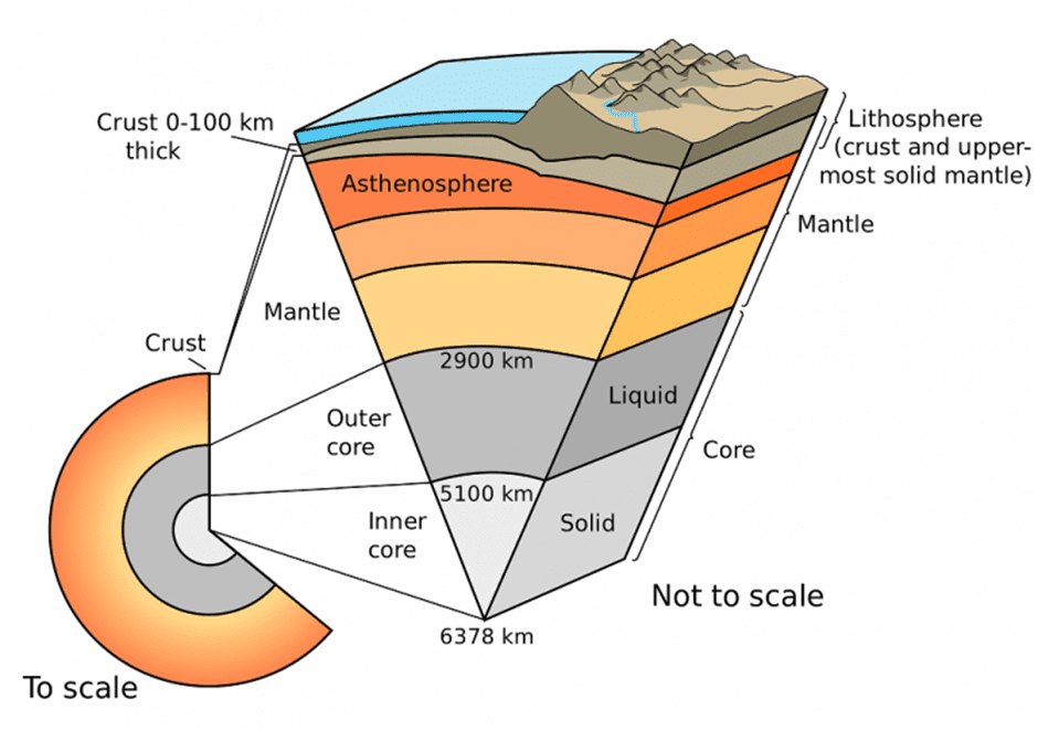 Interior of the Earth
According to Plate tectonics theory
The theory of plate tectonics suggests that the Earth's lithosphere, which includes the crust and upper mantle, is fragmented into several pieces that float on a ductile layer known as the asthenosphere. These fragments, or tectonic plates, move due to convection currents generated in the upper mantle. The plates slide horizontally over the asthenosphere as rigid units.
- The thickness of the lithosphere varies, with oceanic regions ranging from 5-100 km thick and continental areas reaching approximately 200 km thick. Oceanic plates primarily consist of Simatic crust and are relatively thin, while continental plates are made up of Sialic material and are thicker in comparison.
- Tectonic plates can be classified into minor and major plates, as well as continental plates (e.g., Arabian plate) and oceanic plates (e.g., Pacific plate). Some plates are a combination of both continental and oceanic material, such as the Indo-Australian plate.
- The movement of these plates, driven by convection currents in the mantle, is responsible for the formation of various landforms and is the primary cause of all Earth movements. The boundaries between plates are areas of significant geological activity, including seafloor spreading, volcanic eruptions, crustal deformation, mountain building, and continental drift.
- The term "tectonics" originates from the Greek word "tektonikos," meaning building or construction. It refers to the deformation of the Earth's crust as a result of internal forces.
Lithospheric Plates
A plate, in the context of Earth's structure, refers to a large section of the lithosphere, which includes the crust and the rigid upper mantle. These plates float on the more fluid-like asthenosphere below and move independently from one another. There are generally two types of plates: continental plates and oceanic plates. According to the geologist Xavier Le Pichon, the Earth's surface is made up of seven major plates and nine minor plates.Major Tectonic Plates
The major tectonic plates of the Earth include:
- Antarctica Plate: This plate encompasses Antarctica and the surrounding oceanic plate. It is characterized by divergent boundaries, where the plate is moving away from its neighbors.
- North American Plate: This plate is shifting westwards at a velocity of 4-5 cm per year. It is a combination of both oceanic and continental crust.
- South American Plate: Similar to the North American Plate, the South American Plate is also moving westwards, but at a slightly slower rate of 3-4 cm per year. It is also half oceanic and half continental in composition.
- Pacific Plate: This plate is purely oceanic and is moving northwest at a rate of 2-3 cm per year.
- India-Australia-New Zealand Plate: This plate is a combination of the Indian Plate, the Australian Plate, and the New Zealand Plate, all of which are moving in different directions and at varying speeds.
- Africa Plate: This plate includes the continent of Africa as well as the eastern Atlantic Ocean floor. It is a combination of both oceanic and continental crust.
- Eurasia Plate: This plate is primarily continental and is shifting eastwards at a velocity of 2-3 cm per year. It includes the landmass of Europe and Asia as well as the adjacent oceanic plate.
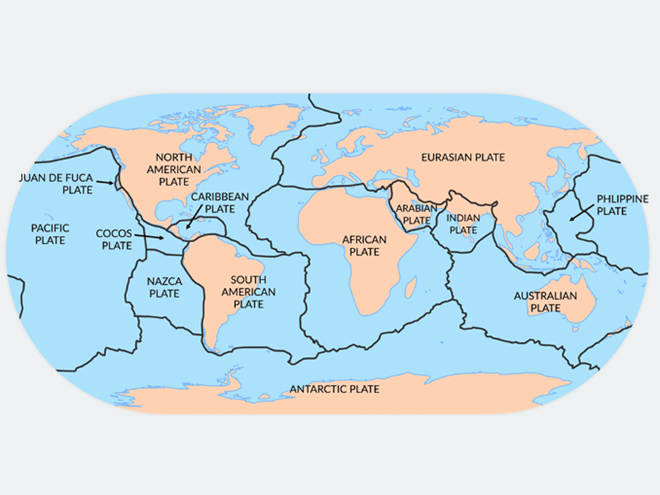 Plate tectonics in the World
Minor Tectonic Plates
- Arabian Plate: This plate mainly consists of the Saudi Arabian landmass.
- Bismarck Plate: Divided into the North Bismarck Plate and South Bismarck Plate.
- Caribbean Plate: A tectonic plate encompassing the Caribbean Sea and surrounding regions.
- Carolina Plate: Located in the eastern hemisphere, this plate straddles the Equator north of New Guinea.
- Cocos Plate: A tectonic plate beneath the Pacific Ocean near Central America.
- Juan de Fuca Plate: Situated between the Pacific and North American plates, this plate is off the coast of the Pacific Northwest.
- Nazca Plate: A tectonic plate located in the eastern Pacific Ocean, off the west coast of South America.
- Philippine Plate: Positioned between the Asiatic and Pacific plates, this plate is beneath the Philippine Sea.
- Persian Plate: A tectonic plate that includes parts of Iran and surrounding regions.
- Anatolian Plate: Also known as the Turkish Plate, it comprises most of the Anatolia (Asia Minor) peninsula, including the country of Turkey.
- China Plate: A tectonic plate that covers the majority of mainland China and its surrounding regions.
- Fiji Plate: Situated between the Pacific Plate and the Indo-Australia Plate, this plate encompasses the Fiji island group.
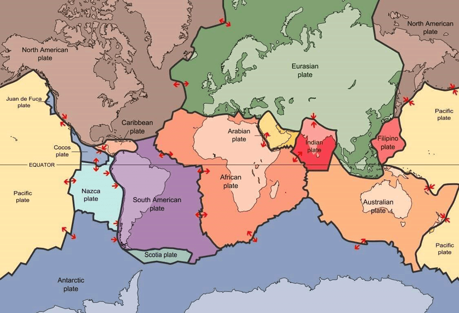 Plate Boundaries Major and Minor
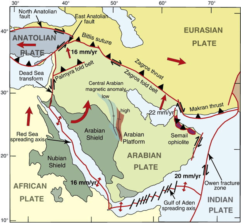 Persian Plate
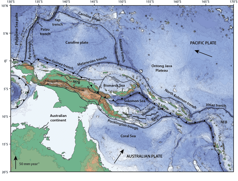 Carolina Plate
Most of the plates include both continental and oceanic crusts. The area of the places is fairly large in comparison to their depth and thickness. It has also been established that the depth of the plates is even less under the oceanic crust.
Three types of motion are possible between the plates:
- Separation or divergent or constructive plate margins
- Closing together or convergent or destructive plate margins
- Transform or conservative plate margin
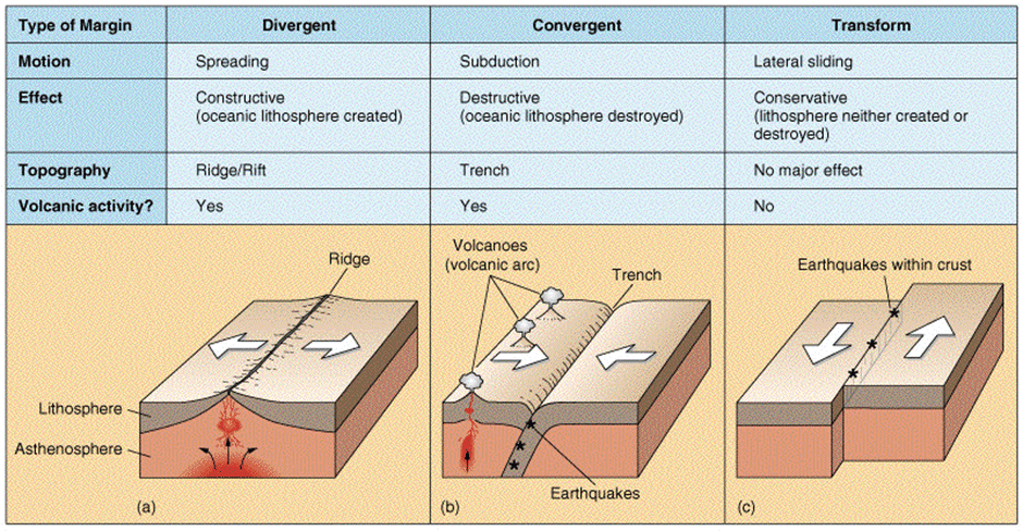 Convergent And Divergent Plate Boundaries
Divergent Boundaries
The boundary between two plates that are moving apart or rifting, Rifting causes Seafloor Spreading.
Features of Divergent Boundaries –
- Mid-ocean ridges
- rift valleys
- fissure volcanoes
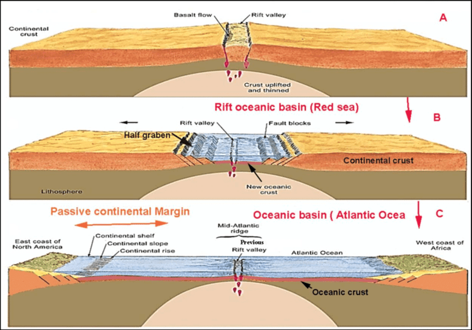 Different stages of development of Divergent Boundary
Continental Rift Valleys
Continental rift valleys can form when divergent boundaries occur within a continent. A prime example of this is the Great East African Rift Valley, which stretches from Ethiopia to Mozambique. Similarly, the Red Sea is a result of continental spreading, where the separation has been significant enough to create a "proto-ocean."
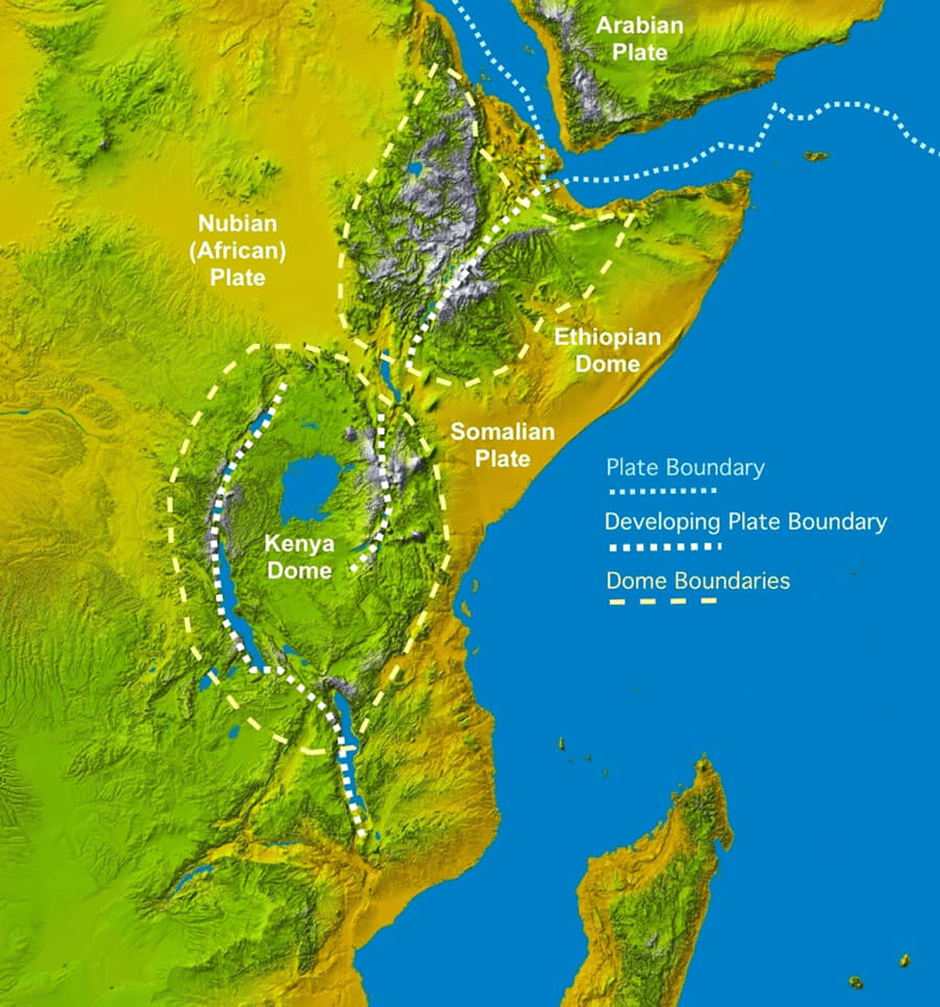 Great African Rift Valley
Convergent Boundaries
Convergent boundaries occur when tectonic plates collide, resulting in the destruction or compression of the Earth's crust. These boundaries are responsible for creating some of the most remarkable landforms on Earth, such as major mountain ranges, volcanoes, and oceanic trenches.There are three types of convergent boundaries:
- Oceanic-continental convergence
- Oceanic-oceanic convergence
- Continental-continental convergence
1. Oceanic-Continental Convergence: In this type of convergence, the denser oceanic lithosphere, which consists of basaltic crust, collides with the lighter continental lithosphere. As a result, the oceanic plate is forced beneath the continental plate in a process known as subduction. The subducting slab pulls the rest of the plate along with it, which is believed to be the primary driver of plate movement.
2. Oceanic-Oceanic Convergence: When two oceanic plates collide, subduction also occurs. As one oceanic plate is forced beneath the other, an oceanic trench forms, accompanied by shallow and deep-focus earthquakes and volcanic activity. Over time, a volcanic island arc develops, such as the Aleutian Islands and the Mariana Islands. Eventually, these arcs may mature into more complex island arc systems, like Japan and the islands of Sumatra and Java in Indonesia.
3. Continental-Continental Convergence: In cases where two continental plates converge, subduction does not occur because the continental crust is too buoyant. Instead, massive mountain ranges are formed, such as the Alps. The most striking example of continental collision today is the formation of the Himalayas.
In summary, convergent boundaries are zones where tectonic plates collide, resulting in the formation of various landforms such as mountain ranges, volcanoes, and oceanic trenches. There are three types of convergent boundaries: oceanic-continental, oceanic-oceanic, and continental-continental, each with their unique characteristics and resulting geological formations.
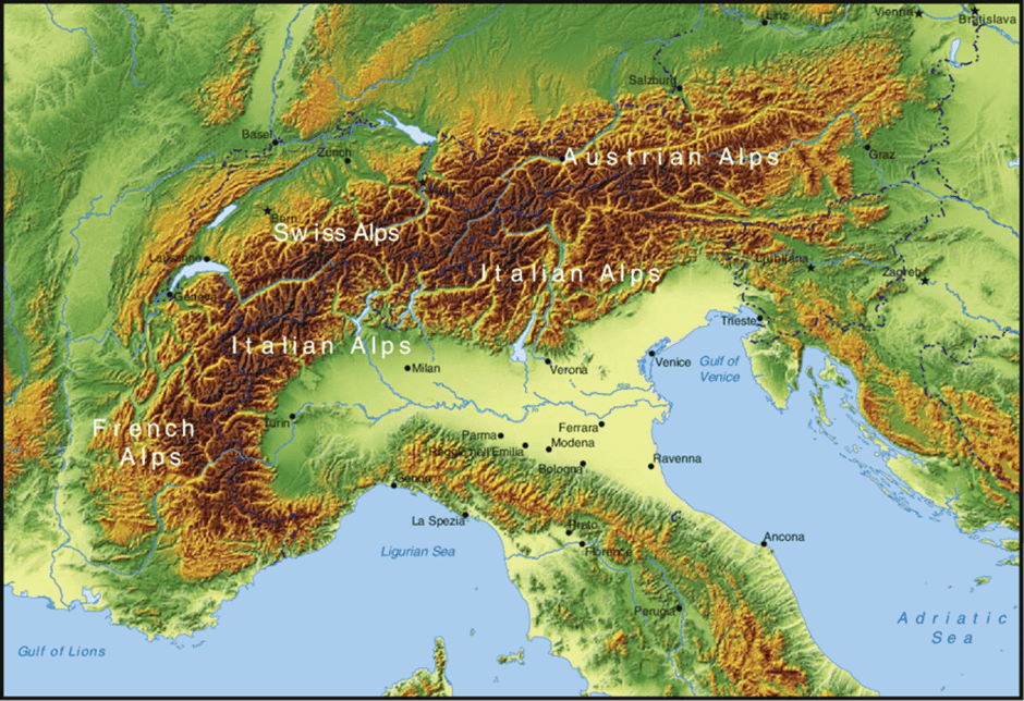 Alps
Alps
Transform Fault Boundaries
- A transform fault, also known as a transform boundary or strike-slip boundary, is a type of fault that occurs along plate boundaries where the motion is primarily horizontal. Transform plate boundaries are areas where two tectonic plates slide past each other, resulting in deformation of the existing landforms rather than the creation or destruction of new landforms. The fracture zone that constitutes a transform plate boundary is referred to as a transform fault.
- In the ocean, these faults typically form perpendicular to mid-oceanic ridges, acting as planes of separation. On continents, well-known examples of transform faults include the North Anatolian Fault and the San Andreas Fault, which lies alarmingly close to Silicon Valley along the western coast of the United States. These faults demonstrate the characteristics of a transcurrent edge, where tectonic plates slide past one another horizontally.
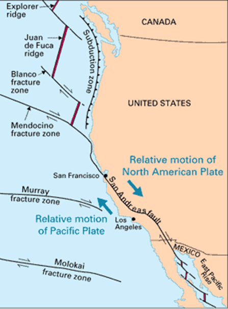 San Andreas Fault California
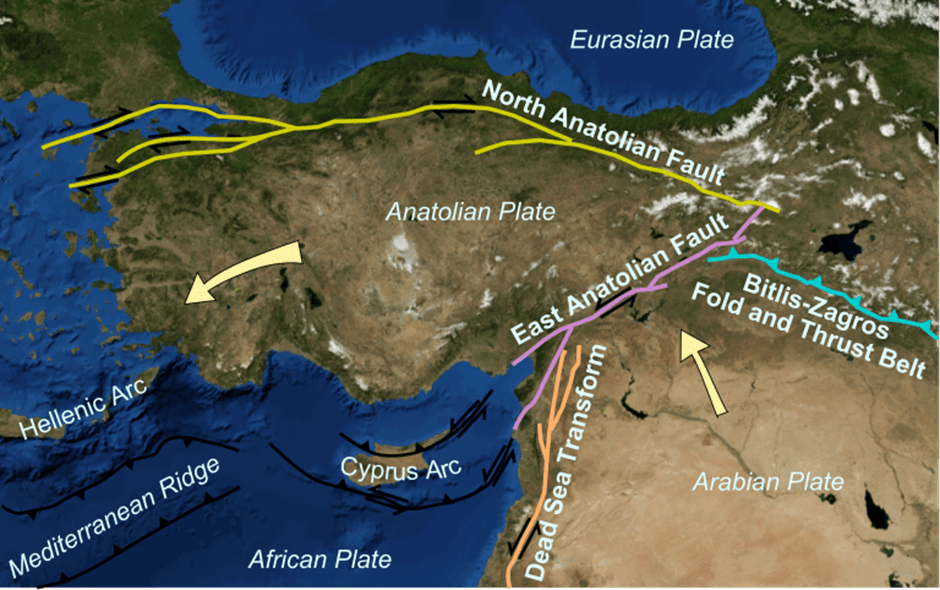 North Anatolian Fault
Evidence supporting plate tectonics includes:
- Deep ocean drilling: The Glomar Challenger was a research vessel that drilled into the ocean floor, providing valuable information about the Earth's crust and plate tectonics.
- JOIDES (Joint Oceanographic Institutions for Deep Earth Sampling): This program collects and analyzes samples from the ocean floor to study the Earth's structure and history, further supporting the theory of plate tectonics.
- Hot spots: These are regions of intense volcanic activity that occur far from plate boundaries. Their existence suggests that the Earth's mantle is dynamic and that heat from the core drives the movement of tectonic plates.
- Paleomagnetism: This is the study of the Earth's magnetic field in the past. It provides evidence for the movement of continents over time and supports the theory of plate tectonics.
- Magnetic reversal and seafloor spreading: The pattern of magnetic reversals found in rocks on the ocean floor provides strong evidence for the process of seafloor spreading, which is a key component of plate tectonics.
The significance of plate tectonics is vast, as it influences various aspects of the Earth's geology:
- Formation of major landforms: Most major landforms, such as mountain ranges and ocean trenches, are formed as a result of plate tectonic processes.
- Creation of new minerals: Magmatic eruptions that occur during plate tectonic activity can bring new minerals to the Earth's surface.
- Economic value: Minerals like copper and uranium, which are valuable resources, are often found near plate boundaries.
- Predicting future landmasses: By studying the current movement of tectonic plates, scientists can predict how the Earth's landmasses will evolve in the future. For example, if current trends continue, North and South America may eventually separate, a piece of land may break off from the east coast of Africa, and Australia may move closer to Asia.
Conclusion
The Plate Tectonics Theory is a groundbreaking framework that explains the dynamic processes and features of Earth's crust and the forces within it. Developed in the 1960s, this theory has advanced our understanding of Earth's geological processes and the formation of diverse features. By studying the interactions between the lithosphere and asthenosphere, as well as the movement of tectonic plates, scientists can explain the creation of major landforms, predict future landmasses, and uncover valuable resources. The evidence supporting plate tectonics, such as deep ocean drilling, hot spots, and paleomagnetism, has significantly contributed to our understanding of Earth's complex geology.Frequently Asked Questions (FAQs) of Plate Tectonics
What is the main difference between Wegener's Continental Drift Theory and the Plate Tectonics Theory?
Wegener's Continental Drift Theory proposed that continents were once connected and gradually drifted apart, but it lacked a mechanism to explain this movement. Plate Tectonics Theory, on the other hand, provides a comprehensive explanation of the movement of the Earth's crust by describing the interactions between the lithosphere and asthenosphere, including the process of seafloor spreading and the role of convection currents in the mantle.
What are the three types of plate boundaries and their associated geological features?
The three types of plate boundaries are divergent, convergent, and transform. Divergent boundaries are characterized by plates moving apart, leading to features such as mid-ocean ridges and rift valleys. Convergent boundaries involve plates colliding, resulting in the formation of mountain ranges, volcanoes, and oceanic trenches. Transform boundaries occur when plates slide past each other, causing deformation of landforms rather than creating or destroying them.
How do convection currents in the mantle contribute to plate tectonics?
Convection currents are generated in the mantle due to the heat from the Earth's core. These currents cause the semi-fluid asthenosphere to rise, spread out, and then sink back down, creating a circular motion. This movement of the asthenosphere drives the movement of the lithospheric plates that float on top of it, facilitating the processes of seafloor spreading, subduction, and plate movement.
What role do subduction and seafloor spreading play in the Plate Tectonics Theory?
Subduction is the process by which one tectonic plate is forced beneath another, typically occurring at convergent boundaries. This process recycles the crust material back into the mantle and drives the movement of the plates. Seafloor spreading, on the other hand, occurs at divergent boundaries where new crust is formed as molten material rises from the mantle and solidifies. This process results in the expansion of the seafloor and the movement of continents.
How does the study of paleomagnetism support the Plate Tectonics Theory?
Paleomagnetism involves the study of the Earth's magnetic field in the past, as recorded in rocks and minerals. This field of study has provided evidence for the movement of continents over time, showing that the Earth's magnetic poles have changed positions relative to the continents. Additionally, the pattern of magnetic reversals found in rocks on the ocean floor provides strong evidence for seafloor spreading, a key component of plate tectonics.
|
303 videos|635 docs|252 tests
|
FAQs on Plate Tectonics - Geography Optional for UPSC
| 1. What is plate tectonics theory? |  |
| 2. What are lithospheric plates? |  |
| 3. What are convergent boundaries? |  |
| 4. What are transform fault boundaries? |  |
| 5. How does plate tectonics theory explain geological phenomena? |  |


