Transport & Communication Class 12 Geography

Means of Transport
One can use different modes of transportation to transfer goods, commodities, and ideas from one location to another. The primary means of transportation include:
Land Transport
In India, the use of road transport for carrying people and goods has been prevalent for a long time, dating back to ancient times when unpaved roads and footpaths were utilized. However, with advancements in technology, there are now paved roads, railways, cableways, and pipelines that allow for the transportation of large quantities of goods and passengers.
Road Transport
- India boasts one of the world's largest road networks, with a total length of 42.3 lakh kilometers. Road transport accounts for 85% of passenger traffic and 70% of freight traffic each year, making it the preferred mode of transport for short distances.
- The first attempt to modernize India's road network was the "Nagpur Plan" in 1943. However, due to a lack of coordination among the princely states and British India, the plan was not implemented.
- After independence, the government launched a twenty-year road plan in 1961 to improve road conditions in the country. However, the majority of roads are still concentrated in and around urban areas, leaving rural and remote regions with limited connectivity.
- To aid in construction and maintenance, roads are classified as National Highways (NH), State Highways (SH), Major District Roads, and Rural Roads.
National Highways
- National Highways (NH) are roads that are constructed and maintained by the central government of India. They serve as crucial links for inter-state transport and the movement of defense personnel and equipment in strategic regions.
- As of 2008-09, the total length of National Highways in India was 70,934 km, which is a significant increase from the 19,700 km in 1951. These highways connect state capitals, major cities, important ports, railway junctions, and other significant locations, despite only constituting 1.67% of the total road length.
- The National Highways Authority of India (NHAI-195) is an autonomous body under the Ministry of Surface Transport. It is responsible for the development, maintenance, operation, and quality improvement of National Highways.
National Highways Development Projects
- The Golden Quadrilateral is a 5846 km long high-density corridor with 4/6 lanes that aims to connect India's four major metropolitan cities of Delhi, Mumbai, Chennai, and Kolkata. This corridor is designed to significantly reduce the time, distance, and cost of movement between these cities. Its construction has proven effective in reducing travel time and costs between the mega-cities of India.
- In addition to the Golden Quadrilateral, there are two other major corridors in India: the North-South Corridor and the East-West Corridor. The North-South Corridor spans 4076 km and connects Srinagar in Jammu and Kashmir with Kanyakumari in Tamil Nadu, including the Kochi-Salem Spur. The East-West Corridor is a 3640 km long road that connects Silchar in Assam with the port town of Porbandar in Gujarat.
State Highways
- These roads are linked to the National Highways and connect state capitals with district headquarters and other significant towns. They constitute around 4% of the total road length, and their construction and maintenance are the responsibility of the state governments.
District Roads
- These roads link important nodes within districts, such as district headquarters, and account for a significant 60.83% of the total road length in the country.
Rural Roads
- Rural roads in India serve as vital links for transportation within rural areas. They make up approximately 33.86% of the country's total road length.
Other Roads
These include Border Roads and International highways:
- Border Roads are crucially important routes located along India's Northern and North-Eastern boundaries. Their construction and maintenance are the responsibility of the Border Road Organisation (BRO), established in May 1960 with the objective of enhancing economic development and defense preparedness by rapidly and systematically improving strategically vital border roads.
- One of BRO's significant accomplishments is the construction of roads in high altitude mountainous regions connecting Chandigarh to Manali (Himachal Pradesh) and Leh (Ladakh) at an average height of 4270 meters above sea level. The total length of the border roads constructed by BRO in 2005 was 40450 km, and in addition to their construction and maintenance, BRO also undertakes snow clearance in high altitude areas.
- International Highways are constructed with the objective of fostering harmonious relations with neighboring countries and providing effective connectivity to India.
Density of Roads
- The distribution of roads across India is not even. One way to compare road networks in different regions is by measuring the road density, which is the length of roads per 100 square kilometers of area. The national average road density was 125.02 km in 2008.
- The road density varies depending on the terrain and level of economic development. States like Uttar Pradesh and major southern states have higher road density, with Uttar Pradesh having the highest road density of 532.27 km.
- On the other hand, the Himalayan region, North-Eastern region, Madhya Pradesh, and Rajasthan have lower road density, with Jammu and Kashmir having the lowest road density of 10.04 km. The quality of roads is also better in plains than in high altitude areas, rainy regions, and forested areas.
Rail Transport
- India boasts one of the world's lengthiest railway networks, serving as a crucial facilitator of both freight and passenger transportation, and contributing significantly to the nation's economic growth. As Mahatma Gandhi noted, Indian railways have also played a role in unifying the country's diverse cultures towards the cause of India's freedom struggle.
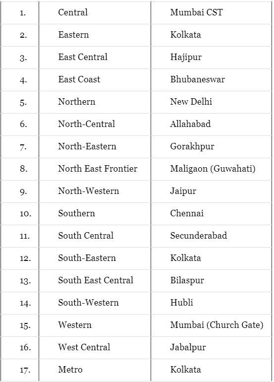
- The inaugural Indian railway commenced in 1853, covering a distance of 34 km from Bombay to Thane. The Indian Railways network, the largest government undertaking in India, spans 64,460 km as of March 31st, 2011. Given the sheer size of this railway network, it has been divided into seventeen zones to ease the burden of centralised railway management.
These are as follows:
Railway Zone Headquarters
Gauges in Indian Railways
The Indian Railways is classified into three categories based on the track width:
- Broad Gauge: The rails are 1.676 meters apart and the total length of these tracks was 55,188 km in 2011.
- Metre Gauge: The rails are 1 meter apart and the total length of these tracks was 6,809 km in 2011.
- Narrow Gauge: The rails are 0.762 meters or 0.610 meters apart, and the total length of these tracks was 2,463 km in 2011. Narrow gauge tracks are primarily found in hilly areas.
Indian Railways has taken major steps to improve the performance of this means of transport like:
- The process of converting the metre and narrow gauges to broad gauge involves replacing the existing tracks and upgrading the infrastructure.
- Additionally, the adoption of diesel and electric engines instead of steam engines can contribute to a cleaner environment. The introduction of metro rail systems in cities like Kolkata and Delhi has also been implemented as a means of improving transportation.
The British initiated the development of railways in India, but after independence, efforts were made to extend railway routes to previously underserved areas. Notably, the construction of the Konkan Railway along the western coast, which connects Mumbai to Mangalore, was a significant achievement.
The Konkan Railway, completed in 1998, spans 760 km from Roha in Maharashtra to Mangalore in Karnataka, and is considered a remarkable feat of engineering. Despite the availability of other forms of transportation, railways remain the most important means of travel for the majority of people. However, in hill states, North-Eastern states, central India, and Rajasthan, the railway network is less dense.
Water Transport
- Water transport is a cost-effective method for carrying heavy goods and passengers, as it is fuel-efficient and environmentally friendly. In India, water transport is categorized into two types: inland waterways and oceanic waterways.
- In the past, before the advent of railways, inland waterways were the primary mode of transport. However, their significance has declined due to tough competition from road and rail transport, as well as the diversion of river water for irrigation purposes, rendering them non-navigable in many areas. Currently, India has approximately 14,500 km of navigable waterways, which is only 1% of the country's overall transportation.
- These waterways include rivers, canals, backwaters, and creeks, among others. While around 3,700 km of major rivers can be navigated by mechanized flat-bottom vessels, only 2,000 km of this is currently used. Similarly, out of the 4,800 km network of navigable canals, only 900 km is accessible by mechanized vessels.
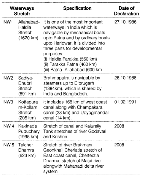
- To oversee the development, maintenance, and regulation of national waterways in India, the Inland Waterways Authority was established in 1986. At present, the authority recognizes three inland waterways as national waterways.
Details of these waterways are provided below:
National Waterways of India
In addition to the three national inland waterways, the Inland Waterways Authority has identified ten other inland waterways in India. Among these, the backwaters of Kerala, known as Kadal, are particularly noteworthy as they not only serve as a mode of transport but also attract tourists. The famous Nehru Trophy Boat Race, also known as Vallamkali, is held in these backwaters.
- Overall, water transport plays a vital role in India's economy, with oceanic routes being a key component. India has a lengthy coastline of around 7,517 km (including islands) that allows for easy access to water transport. With twelve major ports and 185 minor ports, the necessary infrastructure is in place to support these routes.
- Oceanic routes are responsible for moving around 95% of India's foreign trade by volume and 70% by value. These routes not only support international trade but also facilitate transportation between the islands and the rest of the country.
Air Transportation
- Air transport is a highly efficient mode of transportation for both goods and passengers, especially for long distances and areas with challenging terrain and weather conditions. Its introduction in India dates back to 1911, when a short airmail operation from Allahabad to Naini covered a distance of 10 km.
- The Airport Authority of India is responsible for ensuring safe and efficient air traffic and aeronautical communication services in the Indian airspace. It currently manages 126 airports, comprising of 11 international, 86 domestic, and 29 civil enclaves at defence airfields. The management of air transport in India is carried out by two corporations - Air India and Indian Airlines - both of which were nationalised in 1953. In recent years, several private companies have also started offering passenger services.
Air India
- This Indian corporation offers air services for both passengers and cargo traffic on an international scale, connecting all continents of the world.
Indian Airlines
- On December 8th, 2005, the largest state-owned domestic carrier in India, Indian Airlines, underwent a name change, dropping the word "Airlines" from its name and adopting the new brand name "Indian," which now appears on both sides of the fuselage.
- The logo, which displayed "IA" on an orange tail, was replaced with a new logo. The new logo features a blue wheel that is partly visible and was inspired by the Sun Temple at Konark in Odisha. It symbolizes timeless motion, convergence, and divergence, as well as strength and trust that have stood the test of time.
History of Indian Airlines
- In 1911, the first air transport service was launched in India between Allahabad and Naini.
- By 1947, there were four major air transport companies operating in India, including Indian National Airways, Tata Sons Limited, Air Services of India, and Deccan Airways.
- In 1951, four more companies joined the sector, including Bharat Airways, Himalayan Aviation Limited, Airways India, and Kalinga Airlines.
- In 1953, the air transport sector was nationalized, and two corporations were formed: Air India International and Indian Airlines, which is now known as Indian.
- Pawan Hans is a major organization in India that provides helicopter services for hilly areas, tourism in the North-Eastern sector, and mainly to the petroleum sector and tourism.
Oil And Gas Pipelines
- Pipelines are an efficient and effective mode of transportation for liquids, gases and even solids that have been converted to slurry. In India, Oil India Limited (OIL) is responsible for the exploration, production, and transportation of crude oil and natural gas. OIL's significant achievements include the construction of Asia's first cross-country pipeline, which stretches for 1157 km from the Naharkatiya oil field in Assam to the Barauni refinery in Bihar, and was extended to Kanpur, Uttar Pradesh in 1966.
- In addition, OIL has built a vast network of pipelines in the western region of India, including the Ankleshwar-Koyali, Mumbai High-Koyal, and Hazira-Vijaipur-Jagdishpur (HVJ) pipelines. More recently, a 1256 km pipeline has been constructed from Salaya, Gujarat to Mathura, Uttar Pradesh, transporting crude oil from Gujarat to Punjab (Jalandhar) via Mathura. OIL is also in the process of building a 660 km pipeline from Numaligarh to Siliguri.
Communication Networks
Throughout human history, various modes of communication and transportation have been utilized, such as drum beats, hollow tree trunks, smoke signals, and fast runners. With the advancements in science and technology, new and innovative methods of communication have emerged, including the post office, telegraph, printing press, telephone, and satellite.
Based on their scope and effectiveness, modes of communication can be classified into the following categories:
Personal Communication System
- The internet is currently the most advanced and effective personal communication system, particularly in urban areas. Email serves as the primary means for direct communication between users and also provides access to vast amounts of knowledge and information.
- The internet is also increasingly utilized for e-commerce and financial transactions. Essentially, it functions as a vast repository of data, offering detailed information on a wide variety of topics. This mode of communication is less expensive and offers more efficient access to information at a relatively low cost. Additionally, traditional methods of personal communication such as letters, telephones, and faxes are still in use.
Mass Communication System Radio
- In 1923, the Radio Club of Bombay initiated radio broadcasting which quickly became a widespread form of communication in India.
- Recognizing its popularity, the Indian government took over control of this medium of communication in 1930 under the Indian Broadcasting System.
- It was later renamed to All India Radio in 1936 and Akashwani in 1957. Akashwani broadcasts a range of programmes covering topics such as information, education, entertainment, and special news bulletins on parliamentary and state legislature sessions.
Television (TV)
- Television broadcasting has become the most effective audio-visual medium for mass communication and education in India.
- The first television broadcast began in the national capital in 1959, and until 1972 it was the only urban area with TV services.
- After 1972, more centers became operational, and in 1976, TV broadcasting services were separated from All India Radio and given a distinct identity as Doordarshan (DD).
- The INSAT-IA (National Television - D1) launch led to revolutionary development, with the introduction of Common National Programmes (CNP) for the entire network and expansion of services to rural and remote areas.
Satellite Communication
Satellites are a sophisticated form of communication and are important for a country's economic and strategic interests. They provide a comprehensive view of large areas and regulate other forms of communication. Satellite images enable various operations such as forecasting weather, monitoring natural disasters, and border surveillance.
In India, there are two satellite systems based on their configuration and purpose.
Indian National Satellite System (INSAT)
- Established in 1983, this is a versatile satellite system that serves multiple purposes, including telecommunications, meteorological observation, and other data and programs.
Indian Remote Sensing Satellite System (IRS)
- India began its IRS satellite system in March 1988 with the launch of IRS-IA from Vaikanour, Russia.
- Additionally, India has developed its own launch vehicle, the PSLV, for this purpose. The remote sensing satellites in this system gather data in multiple spectral bands and transmit it to ground stations, which is highly beneficial for managing natural resources and other purposes.
- The National Remote Sensing Agency (NRSA) in Hyderabad is responsible for acquiring and processing this data.
|
50 videos|353 docs|37 tests
|
FAQs on Transport & Communication Class 12 Geography
| 1. What are the different means of transport? |  |
| 2. What is the importance of transport in our daily lives? | |
| 3. How does transport contribute to pollution? | |
| 4. Which means of transport is the fastest? | |
| 5. What are the advantages of using public transport? | |


Semester Notes
,Sample Paper
,past year papers
,video lectures
,Summary
,Exam
,Extra Questions
,Previous Year Questions with Solutions
,practice quizzes
,mock tests for examination
,Transport & Communication Class 12 Geography
,shortcuts and tricks
,Transport & Communication Class 12 Geography
,study material
,ppt
,Viva Questions
,Important questions
,Objective type Questions
,Free
,MCQs
,Transport & Communication Class 12 Geography
;


Chapter Notes - Transport & Communication Free PDF Download
Importance of Chapter Notes - Transport & Communication
Chapter Notes - Transport & Communication
Chapter Notes - Transport & Communication Humanities/Arts Questions
Study Chapter Notes - Transport & Communication on the App
|
© EduRev
|
Education Revolution
|


|


