UPSC Mains Answer PYQ 2024: Geography Paper 2 (Section- A) | Geography Optional for UPSC PDF Download
SECTION ‘A’
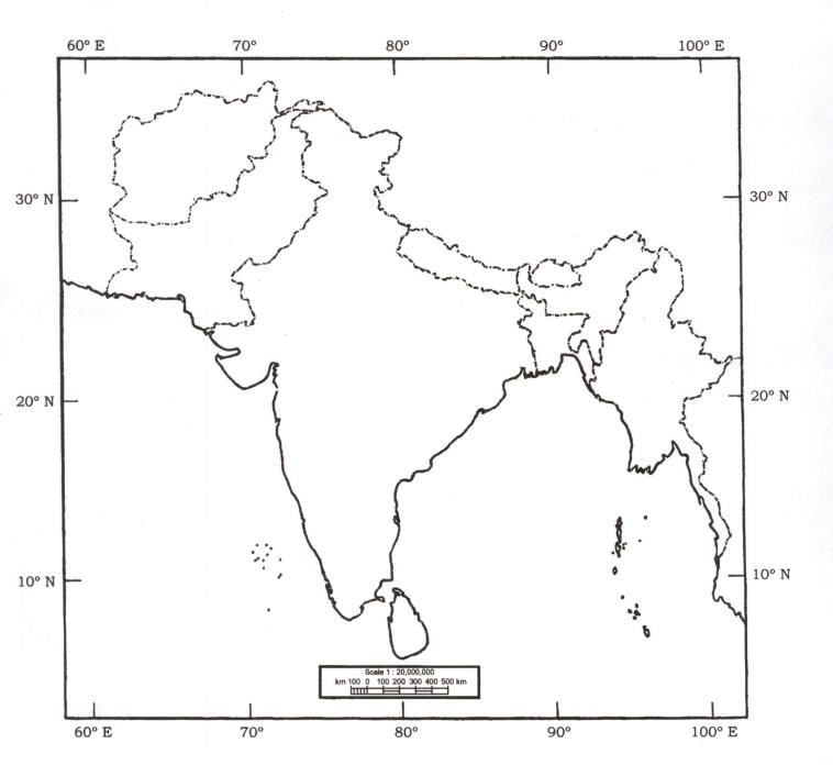
Q1: (a) On the outline map of India provided to you, mark the location of all of the following. Write in your QCA Booklet the significance of these locations, whether physical/ commercial/economic/ecological/environmental/cultural, in not more than 30 words for each entry: Ans:
Ans:
(i) Lunkaransar
- Significance: Known for gypsum mining in Rajasthan; contributes to industrial raw material supply.
(ii) Gua
- Significance: An iron ore mining region in Jharkhand; vital for the steel industry.
(iii) Raidak River
- Significance: A tributary of the Brahmaputra, essential for irrigation and biodiversity in Assam and Bhutan.
(iv) Ekta Nagar
- Significance: Location of the Statue of Unity in Gujarat; promotes cultural and tourism development.
(v) Chandanwari
- Significance: Base camp for the Amarnath Yatra in Jammu & Kashmir; has religious significance.
(vi) Babina
- Significance: A major military cantonment in Uttar Pradesh; contributes to national defense.
(vii) Tatipaka
- Significance: A location for natural gas extraction in Andhra Pradesh; supports energy production.
(viii) Along Airport
- Significance: An important airstrip in Arunachal Pradesh; boosts connectivity and strategic significance.
(ix) Karaikal
- Significance: A port city in Puducherry; supports trade and fishing industries.
(x) Panna
- Significance: Famous for diamond mines and the Panna Tiger Reserve; ecological and economic value.
(b) Discuss the basis of various explanations for the formation of Shiwalik
Ans:
Introduction
The Shiwalik Hills form the outermost range of the Himalayas, created through complex geological processes.
Explanations for Formation
Plate Tectonics:
- Collision of the Indian and Eurasian plates resulted in the folding of sedimentary layers.
Fluvial Activity:
- Depositional activity by rivers like the Indus, Ganga, and Brahmaputra formed the foothills.
Erosion and Sedimentation:
- Sediments eroded from higher ranges were deposited at the foothills.
Conclusion
The Shiwaliks are a dynamic geological feature reflecting tectonic activity, fluvial processes, and erosion.
(c) Conservation and breeding centres are important component of the Action PIan for Vulture Conservation 2020—2025. Why?
Ans:
Introduction
Vultures play a crucial ecological role as scavengers, maintaining ecosystem health. Conservation efforts address their declining population.
Importance of Breeding Centres
Species Recovery:
- Artificial breeding helps sustain endangered species like the Indian white-backed vulture.
Reduction in Mortality:
- Controlled environments prevent poisoning by diclofenac.
Awareness and Research:
- Centres promote public awareness and scientific research on vulture ecology.
Conclusion
Breeding centres are integral to restoring vulture populations and maintaining ecological balance.
(d) North-Eastern States in India are geopolitically sensitive and strategically significant. Explain.
Ans:
Introduction
The North-Eastern region of India is crucial for national security, connectivity, and biodiversity conservation.
Significance
Geopolitical Location:
- Shares borders with China, Myanmar, Bhutan, and Bangladesh.
Strategic Connectivity:
- Acts as India’s gateway to Southeast Asia via the Act East Policy.
Resource Potential:
- Rich in oil, natural gas, and hydropower resources.
Cultural Diversity:
- Promotes India’s soft power through cultural ties with ASEAN nations.
Conclusion
The region requires focused development to harness its strategic potential while addressing vulnerabilities.
Q2: (a) Institutional factors are playing a dominant role in controlling the agricultural prosperity in India. Justify with evidences.
Ans:
Introduction
Institutional factors like policies, credit, and market access significantly influence agricultural outcomes in India.
Evidence of Dominance
Land Reforms:
- Redistribution of land rights boosts productivity (e.g., Operation Barga in West Bengal).
Credit Access:
- Institutional credit through NABARD reduces dependency on informal loans.
Market Infrastructure:
- Initiatives like e-NAM enhance farmers’ income by providing better market linkages.
Policies:
- MSP and PDS secure farm incomes and ensure food security.
Conclusion
Addressing gaps in institutional frameworks can significantly enhance agricultural prosperity in India.
(b) The Indian Space Policy, 2023 supports the commercial presence in space. In what ways will it benefit the socio-economic development and security of India?
Ans:
Introduction
The Indian Space Policy, 2023 emphasizes commercial participation to enhance socio-economic development and security.
Benefits
Economic Growth:
- Boosts private sector investment in satellite manufacturing and launch services.
Technology Development:
- Promotes innovation in AI, geospatial mapping, and space exploration.
Employment Generation:
- Creates jobs in space-related industries and research.
National Security:
- Enhances defense capabilities through advanced surveillance and communication satellites.
Conclusion
The policy is a strategic step toward self-reliance and global leadership in space technology.
(c) Discuss the process of formation of conurbations in India and describe their problems.
Ans:
Introduction
Conurbations are extensive urban agglomerations formed by the merging of cities and towns due to urban sprawl.
Process of Formation
- Economic Development:
- Growth of industries and services attracts migration (e.g., Mumbai-Pune corridor).
- Infrastructure Development:
- Improved connectivity through highways and railways integrates nearby towns.
Problems
- Infrastructure Strain:
- Overburdened transport and utilities.
- Environmental Degradation:
- Loss of green cover and rising pollution levels.
- Social Inequality:
- Rising disparities in housing and access to services.
Conclusion
Planned urban development and regional policies are essential to address these challenges.
Q3: (a) India has wide-ranging regional disparities in economic development. Explain the patterns, implications and challenges.
Ans:
Introduction
India exhibits significant regional disparities due to historical, geographical, and policy factors.
Patterns of Disparities
- Industrial Growth: Concentrated in western and southern states.
- Agriculture: Dominates in northern plains but lags in eastern India.
Implications and Challenges
- Social Inequality:
- Unequal access to healthcare and education.
- Urban-Rural Divide:
- Rural underdevelopment causes migration.
- Policy Imbalances:
- Focused investment in select regions.
Conclusion
Balanced regional development through decentralized planning is crucial for equitable growth.
(b) Discuss the variations in nature of glaciers in India and the emerging issues due to climate change.
Ans:
Introduction
Indian glaciers vary in size, location, and flow dynamics, largely influenced by climatic and geological factors.
Nature of Glaciers
- Himalayan Glaciers: Largest in the Karakoram range; snow-fed rivers.
- Small Glaciers: Found in Uttarakhand and Sikkim; rapidly retreating.
Emerging Issues
- Melting Glaciers:
- Threatens water availability in the Indus, Ganga, and Brahmaputra basins.
- Glacial Lake Outbursts:
- Pose risks of flash floods (e.g., Kedarnath disaster, 2013).
Conclusion
Urgent adaptation and mitigation measures are needed to address the impacts of climate change on glaciers.
(c) Domestic tourism in India has immense local resource potential. Discuss the reasons and its various dimensions.
Ans:
Introduction
Domestic tourism leverages local resources to generate economic and cultural benefits.
Reasons for Growth
- Cultural Diversity: Pilgrimages to sites like Varanasi and Rameswaram.
- Economic Affordability: Affordable transport and accommodation options.
Dimensions
- Economic Impact:
- Job creation in hospitality and transportation.
- Cultural Preservation:
- Promotes heritage conservation (e.g., Hampi).
Conclusion
Domestic tourism strengthens the economy while fostering cultural pride and resource utilization.
Q4: (a) Migration is the reflection of regional disparities. What socio-economic and demographic consequences are experienced at the place of origin and destination?
Ans:
Introduction
Migration reflects regional imbalances, with socio-economic and demographic effects on both origin and destination regions.
Consequences
- At Origin:
- Positive: Remittances improve livelihoods.
- Negative: Loss of workforce, aging population.
- At Destination:
- Positive: Fills labor shortages.
- Negative: Pressure on infrastructure and social tensions.
Conclusion
Addressing regional disparities can reduce the push factors driving migration.
(b) In spite of various tribal area development programmes in India, tribal areas still lag behind. Discuss critically with examples.
Ans:
Introduction
Despite development programs, tribal areas continue to lag in socio-economic indicators.
Reasons for Lag
- Lack of Infrastructure: Poor access to healthcare and education.
- Exploitation: Displacement due to mining and industrial projects.
Examples
- Success: Vanbandhu Kalyan Yojana in Gujarat.
- Failure: Naxalite insurgencies in neglected tribal areas.
Conclusion
Empowering tribals through participatory development is critical for inclusive growth.
(c) Water Scarcity is an important cause of disputes and conflicts in India. Suggest innovative methods for location-based solutions.
Ans:
Introduction
Water scarcity is a pressing issue in India, leading to disputes over resource sharing.
Innovative Solutions
- Watershed Management: Localized rainwater harvesting.
- Technology: Smart water meters for efficient usage.
- Cooperative Models: Inter-state agreements for equitable distribution (e.g., Cauvery Tribunal).
Conclusion
Integrated water resource management can mitigate conflicts and ensure sustainable usage.
|
303 videos|636 docs|252 tests
|
FAQs on UPSC Mains Answer PYQ 2024: Geography Paper 2 (Section- A) - Geography Optional for UPSC
| 1. What are the key topics covered in Geography Paper 2 of the UPSC Mains exam? |  |
| 2. How can candidates effectively prepare for Geography Paper 2 in the UPSC Mains exam? |  |
| 3. What are the common types of questions asked in Geography Paper 2 of the UPSC Mains exam? |  |
| 4. How important is the understanding of current geographical issues for Geography Paper 2? |  |
| 5. What resources are recommended for studying Geography for the UPSC Mains exam? |  |


