Urban Morphology | Geography Optional for UPSC PDF Download
Introduction
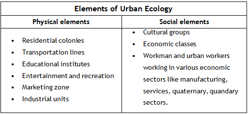
- Urbanization refers to the transformation of a landscape from a rural, agricultural setting to a more industrialized and commercial environment, shifting from a village ecosystem to an urban one. This process involves changes in both the physical and social aspects of the area.
- Urban Morphology, on the other hand, is the study of a city's internal structure. This includes the organization of residential buildings, the layout of roads and streets, and the arrangement of various urban spaces such as entertainment areas, community land, and commercial zones. In essence, Urban Morphology is like a blueprint of a city, identifying different land uses and their distribution within the urban landscape.
- As cities grow and expand, their Urban Morphology evolves accordingly. This development is a result of various historical and social factors that shape the city over time. Urban Morphology is a sub-discipline within the broader field of urban ecology, which examines the relationships between the diverse elements that make up an urban system.
Urban Land Use
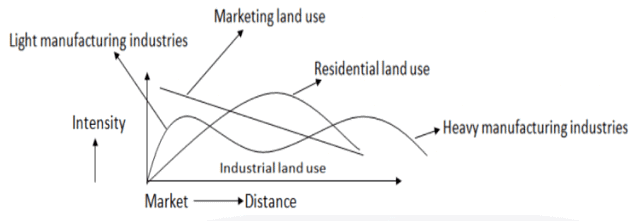
- Urban land use refers to the specific activities taking place in different areas of a city and the degree to which these activities are spatially accumulated, signifying their density, intensity, and concentration. In other words, it illustrates where various activities, such as retail, management, manufacturing, and residential areas, are located and the extent to which they are clustered together.
- In the diagram provided, it can be observed that residential areas are typically situated some distance away from the city center, as these central locations tend to be quite crowded. Light manufacturing industries, such as those producing utensils and jewelry, can be found closer to the city center.
- Conversely, heavy manufacturing industries that require large parcels of land and generate significant pollution are generally located further away from the city center. As for areas designated for market land use, they tend to be situated close to the city center, as markets require a high concentration of consumers, which is typically found near the city center. As the distance from the city center increases, the prevalence of market land use decreases.
- The urban land use can be studied under the following heads

Theories of Urban Morphology
Urban geographers have played a significant role in studying the spatial transformations that urban landscapes have undergone in both material and symbolic aspects throughout the twentieth and twenty-first centuries. Some of the most notable contributions to this field include the urban morphology analyses by Burgess, Hoyt, Harris, and Ullman. Although cities have evolved considerably since these models were established, they are still frequently referenced in urban morphology discussions, even if their relevance is debated.
It is true that most cities have a unique mix of various land uses, but there are often common patterns that can be identified. The models proposed by Burgess, Hoyt, Harris, and Ullman are now an integral part of urban geography's philosophy, and they must be discussed to understand the field's foundational principles.
Urban morphology can be explained by three main theoretical models:
- The Concentric Zone Model
- The Sector Model
- The Multiple Nuclei Model
These models provide a framework for understanding the patterns and structures found in urban environments, and they continue to inform the study of urban geography today.

Concentric Zone Model
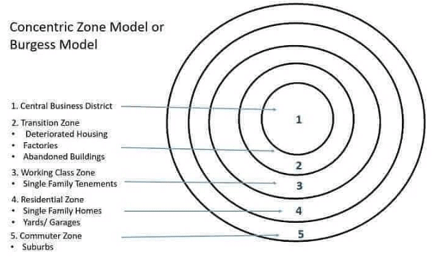
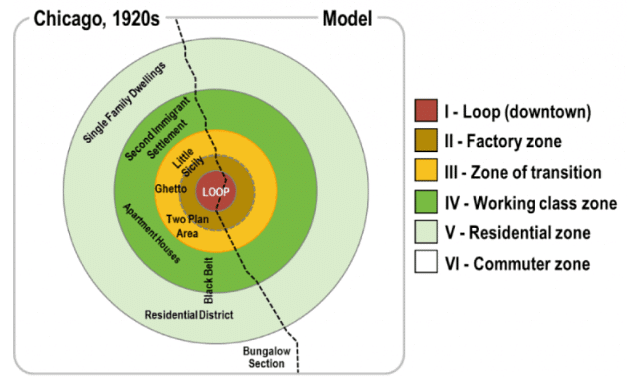
The concentric zone model, developed by Ernest Burgess and Parks in 1925, aimed to explain the structure and growth of cities. This theory, which originated from the Chicago School of thought, is based on land use patterns observed in Chicago and idealized as a model for urban morphology. The model suggests that city development occurs in a concentric pattern, with each zone of land use radiating outwards from a central commercial hub known as the Central Business District (CBD). Burgess's model relies on several key assumptions, including that the area under consideration has a uniform surface, individuals are economically rational, transportation routes converge at the city center, all parts of the city have equal accessibility, and the city's shape is circular. Based on these assumptions, Burgess identified five distinct zones within an American city:
- Central Business District (CBD): This is the core commercial and financial center of the city, where businesses, offices, and retail spaces are concentrated.
- Zone of Transition: This area, surrounding the CBD, is characterized by mixed land use, including industrial, commercial, and residential spaces. It is typically undergoing rapid change and redevelopment.
- Working Men's Homes: This zone consists of housing for the city's working-class population, often in the form of apartments, row houses, or small single-family homes.
- Residential Zone: This area comprises middle-class and upper-class residential neighborhoods, with larger homes and more green space than the inner-city zones.
- Commuter's Zone: This outermost zone consists of suburban areas and satellite towns, where residents typically commute to the city center for work.
According to Burgess, residents in the inner city tend to move outwards over time, seeking better environmental conditions and improved quality of life. Thus, the concentric zone model presents a dynamic picture of urban development, with each zone continually evolving and shifting in response to changing social, economic, and environmental factors.
Zone I – Central Business District (CBD)
The term 'Central Business District' (CBD) was first introduced by Murphy. This area is primarily dedicated to commercial activities, including wholesale and retail marketing. It is home to government offices, corporate offices, and headquarters of various organizations and agencies. The CBD has the highest intensity of land use and extremely high land rentals. All major transportation routes converge in this area, leading to rapid vertical growth with high-rise buildings and skyscrapers. However, the CBD often becomes a dead zone after office hours when commercial activities cease. Examples of CBDs include Downtown in Anglo-America and the Central Cultural District in Eastern Europe and Russia. In India, Rajiv Chowk in Delhi is an example of a CBD. These areas typically feature old and traditional shops selling high-priced items, antiques, and fine handicrafts.
Zone II – Transitional Zone
This zone is mainly occupied by light industries and slums, characterized by a mixed pattern of land use. Industrial workers often settle in this area, leading to the development of slums and ghettos. It is one of the most polluted zones in a city. The settlements in this zone are generally poorly maintained and have a high density of rooms. After the CBD, this zone represents the oldest part of a city.
Zone III – Workmen Housing
This zone is home to skilled middle-class residents who work in manufacturing industries and earn higher incomes than industrial wage earners. As a result, they live in better conditions than their lower-income counterparts.
Zone IV – Residential Zone
This zone is primarily occupied by affluent individuals who prefer to live away from the crowded city center to avoid issues like pollution and congestion. It is an area for the newly wealthy, featuring institutional areas, parks, and other amenities. The zone offers better facilities such as health centers, farmhouses, and spacious residential quarters. Due to advancements in transportation, the wealthy can easily commute to and from the CBD.
Zone V – Commuter's Zone
This zone consists of scattered upper-class housing colonies, hypermarkets, and suburbs. It also serves as a hub for wholesale purchases of grains and vegetables. The dwellings of daily workers can also be found in this zone.
Process of development of concentric zones
- The development of concentric zones begins with high-income individuals preferring to reside close to the commercial district, as it offers them convenience and proximity to their workplace. Over time, the Central Business District (CBD) attracts lower-income migrants due to the availability of job opportunities, which leads to an increase in population density and competition for space.
- As a result, the wealthier residents are pushed to move away from the congested and polluted areas to find a more comfortable living environment with less congestion and pollution. This outward movement of the affluent population creates a ripple effect, causing the middle-class residents, who are typically second or third-generation migrants, to displace the wealthy residents even further from the CBD.
- Fortunately, the development of modern transportation infrastructure, such as motorways, allows these high-income individuals to maintain their connection to the CBD despite living in more distant locations. This ongoing process contributes to the formation of concentric zones, with each successive ring representing different income levels and residential preferences.
Critical evaluation of Concentric Zone Model
- The Concentric Zone Model is a normative model, which means it offers an idealized, theoretical representation of a city. However, the reality of urban land use is far more complex than the model suggests. The model is primarily based on European cities and is more closely aligned with the structure of pre-industrial European towns.
- The model's applicability is limited, as it is more suited for small cities with populations of around one lakh. One significant limitation of the model is that it does not take into account transportation lines, which are essential factors in a city's expansion. As a result, alternative models, such as the Sectoral Model proposed by Hoyt and Davis, have been developed to address these shortcomings.
Sectoral Model
- This model was proposed by Hoyt and Davis. This model takes into account the development of urban centres along major transportation lines.
- Here urban morphology is determined by the network of routes that develop within the city.
- The city in this model is never concentric rather divided into sectors.
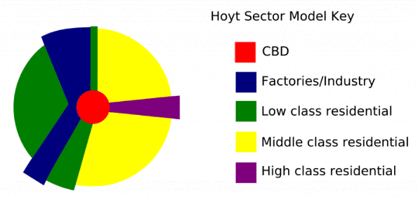
Central Business District (CBD)- Zone 1
- It is the central core of city with circular geometric shape.
- It has no residential usage, only wholesale marketing, headquarters, government building etc are located.
- It is also called blighted part of city because during the night darkness prevails in the building and it becomes no man’s land.
- It is the costliest part of the city.
- Such CBD are the product of industrial revolution and they generally have a planned development model. E.g. Connaught Place New Delhi.
Light manufacturing industries- Zone 2
- This zone consists of light and small scale manufacturing industries and has the mixed pattern of land use with commercial and residential purposes.
- The retail and wholesale market are located in this zone.
- This zone develops along the major communication/transportation lines.
- This zone is usually developed along the main artery connecting city centre.
- It is also one the most polluted areas of the city with high traffic congestion, noisy traffic and slum development.
Lower class residential area (Poor housing)- Zone 3
- This zone is the residential area of the factory workers who work in Zone 2.
- This zone consists of people with low income and has the highest room density with shanty towns and slums.
Middle-class dwelling (Medium housing)- Zone 4
- This zone has better civic amenities than previous two zones.
- It is less polluted and has workers with high income level.
Upper-class residential areas- Zone 5
- This zone is developed along major transportation lines.
- People working in CBD with higher income lives here.
- This zone has easy and direct connectivity with city.
- Professional engineers, doctors, professors, service sector (managers) lives here.
Thus, in Sectoral Model the concentric pattern gets distorted because of the presence of major roads that encourage agglomeration and expansion of certain categories of land uses.
Light manufacturing and supporting labor and worker class expand along a transportation corridor. E.g. Mathura Road (Delhi-Faridabad-Mathura-Agra Highway), NH2 has this type of expansion, whereas, along a well-planned corridor that develops into an expressway or “Boulevard”, the affluent population may prefer to agglomerate. E.g. Jaipur Highway (through Gurgaon-Manesar).
Critical Evaluation
- Even in the Sectoral model the metropolis and megacities can’t be projected and it is more suitable for the district level town.
- The million-plus cities have more than one CBD because the economic functions are highly diversified and all populations can’t be accommodated with all economic functions at a single center.
- Post-industrial revolution cities of Europe which are semi-planned more correspond to this model.
- In India, this model is applicable for some state capitals and larger district towns.
- In order to address the problems in Sectoral Model Harris and Edward Ullman came with the “Multiple Nuclei Model”.
Multiple Nuclei Model
The Multiple Nuclei Model was proposed by Harris and Edward Ullman in their book "Nature of Cities." Unlike the Burgess and Hoyt models, which focus on the expansion and development of urban centers around a single central business district (CBD), the Multiple Nuclei Model takes into account the reality that large urban areas with diverse functions may not be able to rely on just one CBD to cater to the entire population.
This model acknowledges that certain types of services tend to cluster together while repelling others, leading to specialized commercial centers rather than a single hub providing all commercial functions. As a result, Harris and Ullman's model features more than one CBD, with various economic functions spread across a larger geographical area.
According to the Multiple Nuclei Model, a city consists of the following ten zones:
- Central Business District: The primary commercial and business hub of the city.
- Light Manufacturing Zone: An area focused on less intensive industrial activities.
- Lower Class Housing: Residential areas primarily occupied by lower-income residents.
- Middle Class Housing: Residential areas mainly occupied by middle-income residents.
- Upper Class Housing: Residential areas predominantly occupied by higher-income residents.
- Heavy Manufacturing Industries: An area dedicated to more intensive industrial activities.
- Second CBD or Urban Hub: An additional commercial and business center, also known as a New Urban Modern Hub.
- Residential Suburb: Outlying residential areas typically characterized by lower-density housing.
- Industrial Suburb: Outlying areas focused on industrial activities and businesses.
- Commuters Zone: An area where residents primarily live and commute to other areas of the city for work or other activities.
In summary, the Multiple Nuclei Model presents a more realistic representation of large urban areas, with multiple commercial centers and a diverse range of economic functions spread across a vast geographical area. This model accounts for the natural clustering of certain services and the repulsion of others, resulting in specialized commercial hubs and a more accurate depiction of urban development.
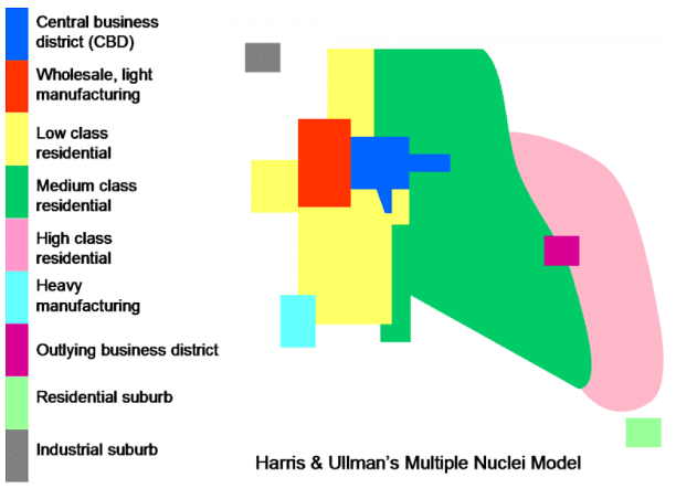
Application
- The Multiple Nuclei Model can be applied to large cities with significant urban industrial growth, occupying extensive geographical areas and undergoing expansion and transition. This model is particularly relevant to modern and planned cities in the United States and Europe, where effective urban policies have led to the development of multiple central business districts (CBDs) that help distribute the population and prevent overcrowding.
- In India, many metropolitan cities exhibit characteristics of the Multiple Nuclei Theory. For instance, in Delhi-NCR, the original CBD is located in the walled city of Chandani Chowk, while South-Ex serves as a center for high-end retail and Nehru Place specializes in electronics and computer peripherals. The commercial and residential suburbs of Gurgaon and Noida also have their own distinct CBDs.
Application of all three models
Although none of the models perfectly represent any city, their partial application can be summarized as follows:
- The Concentric Zone Theory by Burgess applies to small cities and towns like Banaras, Kanchipuram, and Gaya.
- The Sectoral Model is applicable to district towns or towns with quasi-planning, such as capital cities or state capitals like Jaipur and Chandigarh.
- The Multiple Nuclei Model is relevant to megacities and planned cities.
Criticism of all models
These models have some limitations, including:
- The zones depicted in each model are not clearly defined in reality, and each zone usually contains more than one type of land use or housing.
- The models do not consider the characteristics of cities outside the United States and Northwestern Europe. For example, the Burgess model is based on Chicago, the Hoyt model focuses on US cities, and the Harris and Ullman model is limited to cities in economically developed regions.
- The models do not account for redevelopment schemes and modern edge-of-city developments, as most of them predate these events.
- The Burgess and Hoyt models primarily focus on housing, neglecting other land uses.
- The Burgess and Hoyt models assume a flat landscape, which is not always the case.
- Burgess's model does not consider transportation as a major factor in determining a city's structure.
Internal structure of cities across cultural comparison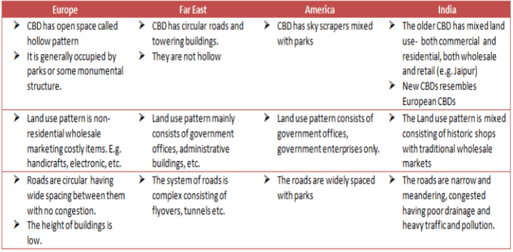

CBD in Russia has a huge ground called “Parades” which are used for assembling and political gathering especially in communal regimes. Examples:
- Moscow, Leningrad
- Beijing, China
- Official building surrounds the ground which is also called “Comrades”.
Conclusion
In conclusion, urban morphology is a critical aspect of understanding the development and structure of cities. The Concentric Zone Model, Sector Model, and Multiple Nuclei Model are foundational theories that provide a framework for analyzing urban land use and the distribution of different activities within a city. While these models have their limitations and may not perfectly represent every urban landscape, they have significantly contributed to the field of urban geography and remain relevant in understanding the spatial organization of cities. As cities continue to evolve and expand, the study of urban morphology becomes increasingly important in guiding urban planning and policy decisions.Frequently Asked Questions (FAQs) of Urban Morphology
What is the main difference between Urbanization and Urban Morphology?
Urbanization refers to the process of transforming a rural landscape into an urban one, involving changes in both physical and social aspects. Urban Morphology, on the other hand, is the study of a city's internal structure, including the organization of residential buildings, layout of roads and streets, and arrangement of various urban spaces.
What are the three main theoretical models of Urban Morphology?
The three main theoretical models of Urban Morphology are the Concentric Zone Model, the Sector Model, and the Multiple Nuclei Model. These models provide a framework for understanding the patterns and structures found in urban environments.
What factors contribute to the formation of concentric zones in the Concentric Zone Model?
The formation of concentric zones is influenced by factors such as high-income individuals preferring to reside close to the commercial district, the CBD attracting lower-income migrants due to job opportunities, and the development of modern transportation infrastructure allowing high-income individuals to maintain their connection to the CBD despite living in more distant locations.
How does the Sector Model differ from the Concentric Zone Model?
The Sector Model differs from the Concentric Zone Model in that it takes into account the development of urban centers along major transportation lines. In the Sector Model, the city is divided into sectors rather than concentric zones, with land use patterns developing along these transportation corridors.
Which urban morphology model is most applicable to modern megacities?
The Multiple Nuclei Model is most applicable to modern megacities as it accounts for more than one Central Business District (CBD) and highly diversified economic functions distributed over a much larger geographical area. This model is more reflective of the complex structure and land use patterns observed in large urban centers today.
|
304 videos|717 docs|259 tests
|


