


All Exams >
Civil Engineering (CE) >
Geomatics Engineering (Surveying) >
All Questions
All questions of Theodolite, Compass & Traverse Surveying for Civil Engineering (CE) Exam
In a closed traverse, the sum of south latitudes exceeds the sum of north latitudes and the sum of east departures exceeds the sum of west departures. The closing line will lie in the- a)N-W quadrant
- b)N-E quadrant
- c)S-E quadrant
- d)S-W quadrant
Correct answer is option 'C'. Can you explain this answer?
In a closed traverse, the sum of south latitudes exceeds the sum of north latitudes and the sum of east departures exceeds the sum of west departures. The closing line will lie in the
a)
N-W quadrant
b)
N-E quadrant
c)
S-E quadrant
d)
S-W quadrant

|
Juhi Choudhary answered |
The closing line will have south latitude and east departure. Therefore it will lie in S-E quadrant.

What is the magnetic declination at a place if the magnetic bearing of the sun at noon is 184°- a)4°W
- b)4°E
- c)176°W
- d)176°E
Correct answer is option 'A'. Can you explain this answer?
What is the magnetic declination at a place if the magnetic bearing of the sun at noon is 184°
a)
4°W
b)
4°E
c)
176°W
d)
176°E
|
|
Zoya Sharma answered |
True bearing
= Magnetic bearing + Declination
∴ 180° = 184° + Declination
or Declination = -4° = 4°W
= Magnetic bearing + Declination
∴ 180° = 184° + Declination
or Declination = -4° = 4°W
The error due to eccentricity of inner and outer axes can be eliminated by - a) reading both verniers and taking the mean of the two
- b)taking both face observations and taking the mean of the two
- c)double sighting
- d)taking mean of several readings distributed over different'portions of the graduated circle.
Correct answer is option 'A'. Can you explain this answer?
The error due to eccentricity of inner and outer axes can be eliminated by
a)
reading both verniers and taking the mean of the two
b)
taking both face observations and taking the mean of the two
c)
double sighting
d)
taking mean of several readings distributed over different'portions of the graduated circle.
|
|
Juhi Choudhary answered |
Error due to eccentricity of inner and outer axes means that the centre of graduated horizontal circle does not coincide with the centre of vernier plate.
Which one of the following is carried out by two theodolite method?- a)Circular curve ranging
- b)Tacheometric survey
- c)Geodetic survey
- d)Astronomical survey
Correct answer is option 'A'. Can you explain this answer?
Which one of the following is carried out by two theodolite method?
a)
Circular curve ranging
b)
Tacheometric survey
c)
Geodetic survey
d)
Astronomical survey
|
|
Simran Saha answered |
Circular Curve Ranging using Two Theodolite Method
Circular curve ranging is a process of determining the position of points on a curve with respect to a given reference line. Two theodolite method is a common technique used to carry out circular curve ranging. This method involves the use of two theodolites placed at two stations on the reference line.
Steps involved in circular curve ranging using two theodolite method:
1. Setting up the theodolites: Two theodolites are set up at two stations on the reference line. The distance between the two stations should be at least equal to the radius of the curve.
2. Taking readings: The theodolites are used to take readings of the angles between the reference line and the tangent at each point on the curve. The readings are taken from both the stations.
3. Calculating the position of points on the curve: The angles measured at each point on the curve are used to calculate the position of the point with respect to the reference line. This calculation involves trigonometry and geometry.
4. Plotting the curve: The points calculated in the previous step are plotted on a graph to obtain the curve.
Advantages of two theodolite method:
1. It is a simple and accurate method of circular curve ranging.
2. It can be used in areas with difficult terrain.
3. It is relatively inexpensive compared to other methods.
Disadvantages of two theodolite method:
1. It requires skilled personnel to operate the instruments.
2. It is time-consuming and may take longer to complete compared to other methods.
Conclusion:
Circular curve ranging using two theodolite method is a useful technique in civil engineering for determining the position of points on a curve with respect to a reference line. It is a simple and accurate method that can be used in a variety of situations. However, it does require skilled personnel to operate the instruments and can be time-consuming.
Transit rule of balancing a traverse is applied when- a)the linear and angular measurements are of same precision.
- b)the linear measurements are more precise than angular measurements.
- c)the angular measurements are more precise than linear measurements.
- d)the linear measurements are proportional to l and angular measurements are proportional to (1/l) where l is the length of the line.
Correct answer is option 'C'. Can you explain this answer?
Transit rule of balancing a traverse is applied when
a)
the linear and angular measurements are of same precision.
b)
the linear measurements are more precise than angular measurements.
c)
the angular measurements are more precise than linear measurements.
d)
the linear measurements are proportional to l and angular measurements are proportional to (1/l) where l is the length of the line.
|
|
Aditya Deshmukh answered |
The Transit Rule of Balancing a Traverse, also known as the Compass Rule, states that when the angular measurements are more precise than the linear measurements, the angular measurements should be used to balance the traverse.
When the linear measurements are more precise than the angular measurements, it is more appropriate to use the Distance Rule, also known as the Chain Rule. In this case, the linear measurements are used to balance the traverse.
It's crucial to have in mind that the Transit Rule and the Distance Rule are applied in different conditions, as they are used to balance the traverse differently depending on the precision of the measurements.
The option "d" is not correct because the Transit rule depends on the precision of the measurements and the proportionality of measurements with respect to length is not affecting the decision of choosing the rule.

Closed contours, with higher value inwards, represent a- a)depression
- b)hillock
- c)plain surface
- d)None of the above
Correct answer is option 'B'. Can you explain this answer?
Closed contours, with higher value inwards, represent a
a)
depression
b)
hillock
c)
plain surface
d)
None of the above

|
Gate Funda answered |
Closed contours with higher values inwards represent a depression.
Explanation:
- Depression: In topographic maps, a depression is shown by closed contours with the highest elevation in the center. These contours are typically marked with hachure lines (short lines) pointing towards the center of the depression to indicate that the terrain dips downward.
- Hillock: A hillock would have the highest elevation at the center, with contours arranged around it in concentric circles, representing a rise in elevation, not a depression.
- Plain Surface: A plain would be represented by evenly spaced, straight, or gently curved contours, showing a flat or nearly level surface.
Answer:
If the declination is 5°40'W, which one of the following magnetic bearing would represent the true bearing of S25°20'E?- a)S19°20'E
- b)S31°0'E
- c)S20°0'E
- d)S19°20'W
Correct answer is option 'B'. Can you explain this answer?
If the declination is 5°40'W, which one of the following magnetic bearing would represent the true bearing of S25°20'E?
a)
S19°20'E
b)
S31°0'E
c)
S20°0'E
d)
S19°20'W
|
|
Sreemoyee Deshpande answered |
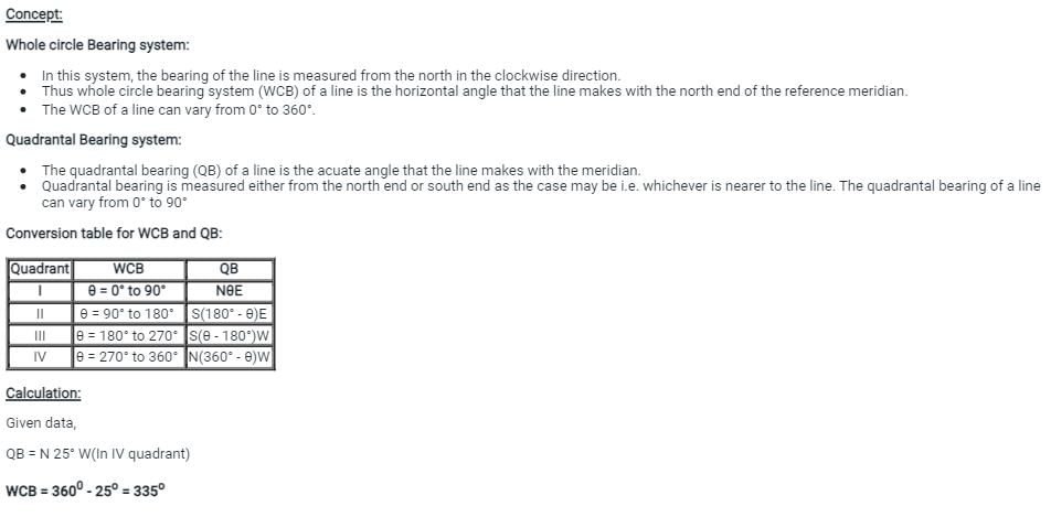
Note that negative (W) declination should be added to quadrantal bearing in second and fourth quadrant i.e. NθW or SθE and it should be subtracted from quadrantal bearing in first and third quadrant i.e., NθE and SθW. Reverse should be done for positive (E) declination.
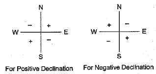
True bearing = S25°20'E+5°40'
= S31°0'E
True bearing = S25°20'E+5°40'
= S31°0'E
If the coordinates bf A are 100 N and 200 E and those of Care 100 S end 200 E, then the length AC is- a)400.00
- b)282.84
- c)244.94
- d)200.00
Correct answer is option 'D'. Can you explain this answer?
If the coordinates bf A are 100 N and 200 E and those of Care 100 S end 200 E, then the length AC is
a)
400.00
b)
282.84
c)
244.94
d)
200.00
|
|
Naina Das answered |
Given information:
Coordinates of A: 100 N and 200 E
Coordinates of C: 100 S and 200 E
To find: Length of AC
Approach:
1. Draw a rough diagram with the given coordinates.
2. Calculate the difference in latitude and longitude between A and C.
3. Use the Pythagorean theorem to calculate the distance between A and C.
Calculation:
1. The given coordinates can be plotted on a map as shown below.
```
A (100 N, 200 E)
|
|
|
|
|
|
|
|
C (100 S, 200 E)
```
2. The difference in latitude between A and C is 100 N - 100 S = 200 units (since one degree of latitude is equal to 60 nautical miles or 111.12 km).
The difference in longitude between A and C is 200 E - 200 E = 0 units (since the two points are on the same longitude).
3. The distance between A and C can be calculated using the Pythagorean theorem as follows:
```
AC² = (latitude difference)² + (longitude difference)²
AC² = 200² + 0²
AC² = 40,000
AC = √40,000
AC = 200 units
```
Therefore, the length of AC is 200.00 units.
Answer: option D.
Which of the following method doesn’t require the calculation of latitudes and departures?- a)Graphical method
- b)Axis method
- c)Bowditch’s method
- d)Transit method
Correct answer is option 'A'. Can you explain this answer?
Which of the following method doesn’t require the calculation of latitudes and departures?
a)
Graphical method
b)
Axis method
c)
Bowditch’s method
d)
Transit method
|
|
Tanvi Shah answered |
Since Graphical method involves a rough calculation and plotting of traverse directly from the field notes, it is not necessary for calculating latitudes and departures.
A series of closely spaced contour lines represents a- a)steep slope
- b)gentle slope
- c)uniform slope
- d)plane surface
Correct answer is option 'A'. Can you explain this answer?
A series of closely spaced contour lines represents a
a)
steep slope
b)
gentle slope
c)
uniform slope
d)
plane surface
|
|
Lavanya Menon answered |
Closed contours ⇒ Steep slope
Apart contour lines ⇒ Gentle slope
Equally spaced ⇒ Uniform slope Straight parallel and equally speed contours ⇒ plane surface
Apart contour lines ⇒ Gentle slope
Equally spaced ⇒ Uniform slope Straight parallel and equally speed contours ⇒ plane surface
If fore bearing of a line is S49°52'E (assuming there is no local attraction), the back bearing of the line will be- a)S52°49'E
- b)S49°52'E
- c)N49°08'E
- d)N49°52'W
Correct answer is option 'D'. Can you explain this answer?
If fore bearing of a line is S49°52'E (assuming there is no local attraction), the back bearing of the line will be
a)
S52°49'E
b)
S49°52'E
c)
N49°08'E
d)
N49°52'W
|
|
Anisha Chakraborty answered |
if the fore bearing of a line is given as the quadrantal bearing, then back bearing is numerically equal to the fore bearing. However N changes to S and Exchanges to W and vice versa.
Balancing methods can be applied only when________- a)Survey forms a closed triangle traverse
- b)Survey forms an irregular shaped traverse
- c)Survey forms a closed polygon traverse
- d)Survey forms a closed circular traverse
Correct answer is option 'C'. Can you explain this answer?
Balancing methods can be applied only when________
a)
Survey forms a closed triangle traverse
b)
Survey forms an irregular shaped traverse
c)
Survey forms a closed polygon traverse
d)
Survey forms a closed circular traverse

|
Sahana Chavan answered |
The correct answer is option 'C', which states that balancing methods can be applied only when the survey forms a closed polygon traverse.
Explanation:
Balancing methods in surveying are used to adjust the measured angles and distances to ensure that the traverse is closed and accurate. These methods are employed to minimize the errors and discrepancies that may arise during the surveying process.
A closed polygon traverse refers to a survey where the starting point and the ending point are the same, and all the lines form a closed shape. This type of traverse is essential for applying balancing methods because it allows for the calculation and adjustment of the errors in the survey.
Here are the reasons why balancing methods can be applied only when the survey forms a closed polygon traverse:
1. Error detection: A closed polygon traverse enables the surveyor to identify errors in the measurements. By comparing the sum of the included angles with the expected value (360 degrees for a closed polygon), any discrepancies or mistakes can be detected.
2. Error distribution: Balancing methods distribute the errors proportionately among the measured angles and distances in the traverse. This distribution is based on the principle of least squares, which aims to minimize the overall error in the survey. However, this distribution can only be done accurately when the traverse is closed and forms a polygon.
3. Adjustment computation: Balancing methods involve computing the adjustments required to close the traverse accurately. These adjustments are calculated based on the errors detected and the distribution of these errors among the traverse measurements. To perform these calculations, a closed polygon traverse is necessary.
4. Error correction: Once the adjustments are computed, they can be applied to the measured angles and distances to correct the errors. This correction process ensures that the traverse closes accurately, and the measurements are adjusted to their true values. However, this correction can only be done effectively when the traverse is closed and forms a polygon.
In summary, balancing methods in surveying can only be applied when the survey forms a closed polygon traverse. This type of traverse allows for error detection, error distribution, adjustment computation, and error correction, which are the fundamental steps in balancing a survey. Without a closed polygon traverse, these methods cannot be accurately and effectively applied.
Sum of interior angles must be equal to ______- a)(2n/4) right angles
- b)(2n*4) right angles
- c)(2n+4) right angles
- d)(2n-4) right angles
Correct answer is option 'D'. Can you explain this answer?
Sum of interior angles must be equal to ______
a)
(2n/4) right angles
b)
(2n*4) right angles
c)
(2n+4) right angles
d)
(2n-4) right angles
|
|
Tanvi Shah answered |
The check applied for finding the sum of interior angles is equal to (2n-4) right angles. Similarly, the check for exterior angles is equal to (2n+4) right angles.
If the forebearing of a line AB is 35° and that of line BC 15° then the included angle between the lines is- a)20°
- b)50°
- c)160°
- d)230°
Correct answer is option 'C'. Can you explain this answer?
If the forebearing of a line AB is 35° and that of line BC 15° then the included angle between the lines is
a)
20°
b)
50°
c)
160°
d)
230°
|
|
Lavanya Menon answered |
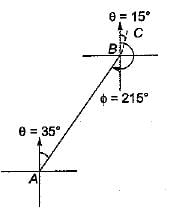
BB of AB = FB + 180°
= 35° + 180° = 215°
∴ included angle between line,
AB and BC = 360° - 215° + 15° = 160°
In order to complete traverse computations, which of the following steps is to be carried out first?- a)Adjusting interior angles
- b)Calculating ∑L and ∑D
- c)Calculating bearings of the angles
- d)Applying corrections
Correct answer is option 'A'. Can you explain this answer?
In order to complete traverse computations, which of the following steps is to be carried out first?
a)
Adjusting interior angles
b)
Calculating ∑L and ∑D
c)
Calculating bearings of the angles
d)
Applying corrections
|
|
Megha Choudhury answered |
C) Calculating the bearings and distances between points
If the sum of northings of a traverse exceeds the sum of southings by 1 m and sum of eastings exceeds the sum of westirigs by 1 m, the resultant closing error and its true bearing respectively are- a)1 m, N45°E
- b)2m,N45°W
- c)

- d)0, N45°E
Correct answer is option 'C'. Can you explain this answer?
If the sum of northings of a traverse exceeds the sum of southings by 1 m and sum of eastings exceeds the sum of westirigs by 1 m, the resultant closing error and its true bearing respectively are
a)
1 m, N45°E
b)
2m,N45°W
c)
d)
0, N45°E
|
|
Gauri Sarkar answered |
B)1 m, S45
c)2 m, N45
d)2 m, S45
Answer: a) 1 m, N45
Explanation:
In a traverse, the closing error is the difference between the sum of the eastings and the sum of the westings, and the difference between the sum of the northings and the sum of the southings.
Given,
Sum of northings > Sum of southings by 1 m
Sum of eastings > Sum of westings by 1 m
So, the closing error would be the difference between these two:
Closing error = (Sum of eastings - Sum of westings) + (Sum of northings - Sum of southings)
= 1 + 1
= 2 m
The true bearing of the closing error can be found using the formula:
tan θ = (Sum of eastings - Sum of westings) / (Sum of northings - Sum of southings)
tan θ = 1/1
θ = tan-1(1)
θ = 45°
Since the sum of eastings is greater than the sum of westings, the closing error is to the north of the starting point. Therefore, the true bearing of the closing error is N45.
Which of the following implies the correct set of methods employed for balancing the traverse?- a)Bowditch’s method, Transit method
- b)Bowditch’s method, Graphical method
- c)Axis method, Transit method, Gale’s method, Co-ordinate method
- d)Bowditch’s method, Axis method, Graphical method, Transit method
Correct answer is option 'D'. Can you explain this answer?
Which of the following implies the correct set of methods employed for balancing the traverse?
a)
Bowditch’s method, Transit method
b)
Bowditch’s method, Graphical method
c)
Axis method, Transit method, Gale’s method, Co-ordinate method
d)
Bowditch’s method, Axis method, Graphical method, Transit method
|
|
Nidhi Patel answered |
B)Transit rule
c)Compass rule
d)Bessel's method
a)Bowditch is the correct answer.
c)Compass rule
d)Bessel's method
a)Bowditch is the correct answer.
Local attraction in compass surveying may exist due to- a)incorrect levelling of the magnetic needle
- b)loss of magnetism of the needle
- c)friction of the needle at the pivot
- d)presence of magnetic substances near the instrument
Correct answer is option 'D'. Can you explain this answer?
Local attraction in compass surveying may exist due to
a)
incorrect levelling of the magnetic needle
b)
loss of magnetism of the needle
c)
friction of the needle at the pivot
d)
presence of magnetic substances near the instrument

|
Arnab Saini answered |
Local attraction is a term used to denote any influence, which prevents the needle from pointing to the magnetic north in a given locality. Difference of fore bearing and back bearing = 0 ⇒ No local attraction.
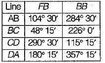
The following bearings were observed while traversing with a compass: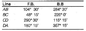 Which stations were affected by local attraction?
- a)A and B
- b)S and C
- c)CandD
- d)Aand D
Correct answer is option 'C'. Can you explain this answer?
The following bearings were observed while traversing with a compass:
Which stations were affected by local attraction?
a)
A and B
b)
S and C
c)
CandD
d)
Aand D
|
|
Pranab Chaudhary answered |
As the difference between F.B and B.B of line AB is exactly 180°, stations A and B are free from local attraction which is not the case with line CD.
Hence stations C and D are affected by local attraction.
Hence stations C and D are affected by local attraction.
Match List-I with List-I I and select the correct answer using the codes given below the lists:
List-l
A. Equally spaced contour lines
B. Contours are always perpendicular to
C. Contours increase in elevation from inside to outside
D. Contours with horizontal equivalent zeroList-II.
1. Steepest slope
2. A vertical cliff
3. A saddle
4. A depression
5. Uniform slope
- a)a
- b)b
- c)c
- d)d
Correct answer is option 'B'. Can you explain this answer?
Match List-I with List-I I and select the correct answer using the codes given below the lists:
List-l
A. Equally spaced contour lines
B. Contours are always perpendicular to
C. Contours increase in elevation from inside to outside
D. Contours with horizontal equivalent zero
List-l
A. Equally spaced contour lines
B. Contours are always perpendicular to
C. Contours increase in elevation from inside to outside
D. Contours with horizontal equivalent zero
List-II.
1. Steepest slope
2. A vertical cliff
3. A saddle
4. A depression
5. Uniform slope
1. Steepest slope
2. A vertical cliff
3. A saddle
4. A depression
5. Uniform slope
a)
a
b)
b
c)
c
d)
d
|
|
Shraddha Datta answered |
Equally spaced contour lines are formed by uniform slope.
Contours are always perpendicular to the steepest slope.
A series of closed contours on map indicates a depression, if the higher values are outside.
Contours never run into one another except in the case of a vertical cliff. In the vertical cliff case, several contours coincide at a point and the horizontal equivalent becomes zero.
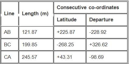
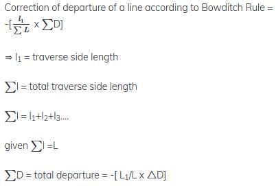
Calculate the correction for departure of BC, using Bowditch’s rule.
- a)362.969
- b)326.969
- c)326.696
- d)323.969
Correct answer is option 'B'. Can you explain this answer?
Calculate the correction for departure of BC, using Bowditch’s rule.
a)
362.969
b)
326.969
c)
326.696
d)
323.969

|
Pioneer Academy answered |
Total error in departure = -228.92 + 326.62 – 98.69 = -0.99
Perimeter of traverse = 114.99 + 217.57 + 319.31 = 567.29 m
Correction for departure of AB = length of AB * total error in departure / perimeter of traverse = 199.85 * -0.99 / 567.29 = -0.349 m. Error is negative then correction is positive i.e., correction = 326.62 + 0.349 = 326.969.
Perimeter of traverse = 114.99 + 217.57 + 319.31 = 567.29 m
Correction for departure of AB = length of AB * total error in departure / perimeter of traverse = 199.85 * -0.99 / 567.29 = -0.349 m. Error is negative then correction is positive i.e., correction = 326.62 + 0.349 = 326.969.
In order to measure the magnetic bearing of a line, the theodolite should be provided with ______- a)extra telescope
- b)spirit level
- c)compass
- d)tabular or trough compass
Correct answer is option 'D'. Can you explain this answer?
In order to measure the magnetic bearing of a line, the theodolite should be provided with ______
a)
extra telescope
b)
spirit level
c)
compass
d)
tabular or trough compass
|
|
Swara Gupta answered |
In order to measure the magnetic bearing of a line, the theodolite should be provided with either a tabular compass or trough compass.
Which method can also be known as Compass rule?- a)Transit method
- b)Bowditch’s method
- c)Graphical method
- d)Axis method
Correct answer is option 'B'. Can you explain this answer?
Which method can also be known as Compass rule?
a)
Transit method
b)
Bowditch’s method
c)
Graphical method
d)
Axis method
|
|
Tanvi Shah answered |
Due to the equal precision of the linear and angular measurements, it can be termed as compass rule.
The contours lines of different elevations can intersect in the case/cases of
1. Vertical diff
2. Cave
3. Over hanging diff- a)Only 3
- b)2 and 3 only
- c)1, 2 and 3
- d)1 and 3 only
Correct answer is option 'B'. Can you explain this answer?
The contours lines of different elevations can intersect in the case/cases of
1. Vertical diff
2. Cave
3. Over hanging diff
1. Vertical diff
2. Cave
3. Over hanging diff
a)
Only 3
b)
2 and 3 only
c)
1, 2 and 3
d)
1 and 3 only
|
|
Bhaskar Rane answered |
Contour Lines and Their Intersection
Contour lines are lines that indicate the elevation of a particular area when drawn on a topographic map. These lines are drawn at a certain interval known as the contour interval. The contour interval is the vertical distance between two consecutive contour lines. When the contour lines intersect, it indicates a change in elevation.
Possible Cases of Intersection
1. Vertical Difference
When contour lines intersect at a perpendicular angle, it indicates a vertical difference between the two lines. This means that there is a sudden change in elevation between the two lines. This can occur in cases such as cliffs, steep slopes, and vertical drops.
2. Cave
Contour lines can intersect in the case of a cave when the cave is located on a slope. The contour lines above the cave will intersect with those below the cave, indicating a change in elevation due to the presence of the cave.
3. Overhanging Difference
When contour lines cross each other but do not intersect at a perpendicular angle, it indicates an overhanging difference. This means that the ground is sloping downwards in one direction and upwards in another direction. This can occur in cases such as overhanging rocks and cliffs.
Correct Answer and Explanation
The correct answer is option 'B' which states that contour lines can intersect in the case of 2 and 3 only. This means that contour lines can intersect in the case of a cave and overhanging difference but not in the case of vertical difference. Contour lines do not intersect at a perpendicular angle in the case of overhanging difference, which rules out option 1. On the other hand, vertical difference only occurs when contour lines intersect at a perpendicular angle, which rules out option 3. Therefore, the only possible cases of intersection are a cave and overhanging difference, which is option 2.
Accuracy of elevation of various points obtained from contour map is limited to- a)1/2 of the contour interval
- b)1/4th of the contour interval
- c)1/3rd of the contour interval
- d)1/5th of the contour interval
Correct answer is option 'A'. Can you explain this answer?
Accuracy of elevation of various points obtained from contour map is limited to
a)
1/2 of the contour interval
b)
1/4th of the contour interval
c)
1/3rd of the contour interval
d)
1/5th of the contour interval
|
|
Rajeev Menon answered |
The accuracy of elevation of various points obtained from a contour map is generally limited to a fraction of the contour interval, but the specific fraction can vary depending on the quality and scale of the map, as well as the level of detail and precision required for the intended use.
As a general rule, the accuracy of elevations obtained from a contour map is typically limited to about 1/2 to 1/3 of the contour interval. For example, if the contour interval is 10 feet, the accuracy of the elevations shown on the map may be limited to +/- 5 to +/- 3.3 feet.
However, it's important to note that this is just a general rule of thumb and that the actual accuracy of the elevations on a contour map may be different depending on the specific circumstances. It's always a good idea to consult the map legend or the map's documentation to determine the accuracy of the elevations shown on the map.
The direction of the magnetic meridian is established at each traverse station and the direction of the line is determined with reference to the magnetic meridian. This method of traversing is called- a)fast needle method
- b)loose needle method
- c)bearing method
- d)fixed needle method
Correct answer is option 'B'. Can you explain this answer?
The direction of the magnetic meridian is established at each traverse station and the direction of the line is determined with reference to the magnetic meridian. This method of traversing is called
a)
fast needle method
b)
loose needle method
c)
bearing method
d)
fixed needle method
|
|
Abhay Kapoor answered |
In the loose needle method, the direction of the magnetic meridian is established at each traverse station and the direction of the line is determined with reference to the magnetic meridian. In other words, the magnetic bearing of each line is determined directly. A theodolite fitted with a compass is used for determining the magnetic bearing of the traverse line. The loose needle method is also known as free needle method.
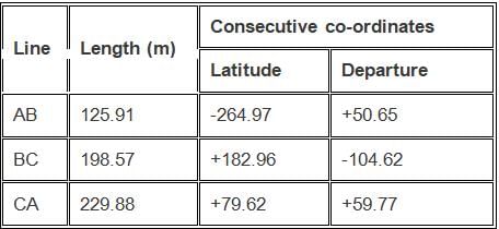
Using transit method, calculate the correction for latitude of BC.
- a)184.78
- b)183.789
- c)185.879
- d)183.987
Correct answer is option 'B'. Can you explain this answer?
Using transit method, calculate the correction for latitude of BC.
a)
184.78
b)
183.789
c)
185.879
d)
183.987
|
|
Pioneer Academy answered |
Total error in latitude = -264.97 + 182.96 + 79.62 = -2.39
Total perimeter of traverse = 125.91 + 198.57 + 229.88 = 554.36 m
Sum of latitudes = 264.97 + 182.96 + 79.62 = 527.55
Now, correction for latitude of BC = latitude of BC * total error in departure / sum of latitudes = 182.96 * (- 2.39) / 527.55 = – 0.829 m. If error is negative, correction is positive
Corrected departure = 182.96 + 0.829 = 183.789.
If the reduced bearing of a line AB is N60°W and length is 100 m, then the latitude and departure respectively of the line AB will be- a)+ 50 m, + 86.6 m
- b)+ 86.6 m , - 5 0 m
- c)+ 50 m, - 86 . 6 m
- d)+ 70.7 m, - 50 m
Correct answer is option 'C'. Can you explain this answer?
If the reduced bearing of a line AB is N60°W and length is 100 m, then the latitude and departure respectively of the line AB will be
a)
+ 50 m, + 86.6 m
b)
+ 86.6 m , - 5 0 m
c)
+ 50 m, - 86 . 6 m
d)
+ 70.7 m, - 50 m
|
|
Deepika Saha answered |
E, the whole circle bearing of AB would be S30W.
To determine the whole circle bearing, you need to add 180 degrees to the reduced bearing if it falls in the first or second quadrant, or subtract 180 degrees if it falls in the third or fourth quadrant.
In this case, N60E falls in the northeast quadrant, so you add 180 degrees to get the whole circle bearing:
N60E + 180 = S120E
However, the convention is to express bearings as angles measured clockwise from north, so you need to subtract the whole circle bearing from 360 degrees:
360 - 120 = 240
Therefore, the whole circle bearing of line AB is S30W or 240 degrees.
The multiplying constant of a theodolite is - a)f/i
- b)(f + d)
- c)

- d)

Correct answer is option 'A'. Can you explain this answer?
The multiplying constant of a theodolite is
a)
f/i
b)
(f + d)
c)
d)
|
|
Aditya Deshmukh answered |
The multiplying constant of a theodolite is a measure of the sensitivity of the instrument. It is defined as the ratio of the change in the reading of the theodolite to the actual change in the angle being measured.
In general, the multiplying constant of a theodolite is given by the formula:
Multiplying constant = (change in reading of theodolite) / (actual change in angle)
So, the correct answer is:
a) f/i
The horizontal angle between the true meridian and magnetic meridian at a place is called- a)azimuth
- b)declination
- c)local attraction
- d)magnetic bearing
Correct answer is option 'B'. Can you explain this answer?
The horizontal angle between the true meridian and magnetic meridian at a place is called
a)
azimuth
b)
declination
c)
local attraction
d)
magnetic bearing

|
Ishaan Kulkarni answered |
The Concept of Declination
The horizontal angle between the true meridian (geographic north) and the magnetic meridian (magnetic north) at any location is known as declination. This angle varies from place to place and changes over time due to shifts in the Earth's magnetic field.
Understanding the Terms
- **True Meridian**: This is the direction along the earth's surface towards the geographic North Pole.
- **Magnetic Meridian**: This direction points towards the magnetic North Pole, which is not fixed and changes due to the movement of molten iron within the Earth's outer core.
Why is Declination Important?
- **Navigational Accuracy**: Knowing the declination helps in accurately converting between true and magnetic bearings, crucial for navigation and surveying.
- **Engineering Applications**: Civil engineers often use declination to ensure proper orientation of structures, as misalignment can lead to significant errors in construction.
Other Related Terms
- **Azimuth**: This is the angle between a reference direction (often true north) and the line to a point, measured in the horizontal plane.
- **Local Attraction**: This phenomenon occurs when nearby magnetic materials affect the local magnetic field, causing deviations in magnetic readings.
- **Magnetic Bearing**: This refers to the direction to an object relative to magnetic north.
Conclusion
Understanding declination is essential for accurate measurements in civil engineering and navigation. It ensures that engineers and surveyors can effectively translate magnetic bearings into true bearings, leading to precision in their work.
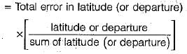
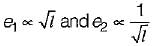
If arithmetic sum of latitudes of a closed traverse is ∑Lat and closing error in latitude is dx, the correction for a side whose latitude is l, as given by Transit Rule, is- a)

- b)

- c)

- d)None of these
Correct answer is option 'A'. Can you explain this answer?
If arithmetic sum of latitudes of a closed traverse is ∑Lat and closing error in latitude is dx, the correction for a side whose latitude is l, as given by Transit Rule, is
a)
b)
c)
d)
None of these
|
|
Abhay Kapoor answered |
Transit method -→ Correction of latitude (and departure) of any side
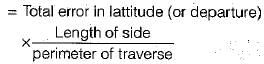
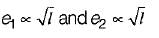
If L is the perimeter of a closed traverse, ΔD is the closing error in departure, the correction for the departure of a traverse side of length l, according to Bowditch rule, is- a)

- b)

- c)

- d)

Correct answer is option 'D'. Can you explain this answer?
If L is the perimeter of a closed traverse, ΔD is the closing error in departure, the correction for the departure of a traverse side of length l, according to Bowditch rule, is
a)
b)
c)
d)
|
|
Maulik Joshi answered |
Bowditch’s method - Correction to latitude (or departure) of any side


Independent co-ordinates can be calculated by using _______- a)Geometric co-ordinates
- b)Cylindrical co-ordinates
- c)Consecutive co-ordinates
- d)Spherical co-ordinates
Correct answer is option 'C'. Can you explain this answer?
Independent co-ordinates can be calculated by using _______
a)
Geometric co-ordinates
b)
Cylindrical co-ordinates
c)
Consecutive co-ordinates
d)
Spherical co-ordinates
|
|
Tanvi Shah answered |
The consecutive co-ordinates which are obtained from the latitudes and departures will be able to derive independent co-ordinates.
The prismatic compass and surveyor’s compass- a)give whole circle bearing (WCB)of a line and quadrantal bearing (QB) of a line respectively
- b)both give QB of a line and WCB of a line
- c)both give QB of a line
- d)both give WCB of a line
Correct answer is option 'A'. Can you explain this answer?
The prismatic compass and surveyor’s compass
a)
give whole circle bearing (WCB)of a line and quadrantal bearing (QB) of a line respectively
b)
both give QB of a line and WCB of a line
c)
both give QB of a line
d)
both give WCB of a line

|
Sanskriti Datta answered |
The prismatic compass is a navigation instrument used to determine the direction of magnetic north. It consists of a magnetic needle that aligns with the Earth's magnetic field and a prism that allows the user to simultaneously view the needle and a distant object. By aligning the needle with the object, the user can determine the direction they are facing or the bearing of the object.
In surveying, the prismatic compass is often used to determine the magnetic bearing of a line or to establish the direction of a boundary. It is commonly used in land surveying, construction, and engineering projects.
Surveyors, on the other hand, are professionals who measure and map the Earth's surface. They use a variety of tools and techniques to gather data about the land, including the use of prismatic compasses. Surveyors play a crucial role in determining property boundaries, creating topographic maps, and providing accurate measurements for construction projects.
Overall, the prismatic compass is a useful tool for surveyors in their field work, as it allows them to determine accurate bearings and directions for their surveys.
If the lower clamp screw is tightened and upper clamp screw is loosened, the theodolite may be rotated- a)on its outer spindle with a relative motion between the vernier and graduated scale of lower plate
- b)on its outer spindle without a relative motion between the vernier and graduated scale of lower plate
- c)on its inner spindle with a relative motion between the vernier and the graduated scale of lower plate
- d)on its inner spindle without a relative motion between the vernier and the graduated scale of lower plate
Correct answer is option 'C'. Can you explain this answer?
If the lower clamp screw is tightened and upper clamp screw is loosened, the theodolite may be rotated
a)
on its outer spindle with a relative motion between the vernier and graduated scale of lower plate
b)
on its outer spindle without a relative motion between the vernier and graduated scale of lower plate
c)
on its inner spindle with a relative motion between the vernier and the graduated scale of lower plate
d)
on its inner spindle without a relative motion between the vernier and the graduated scale of lower plate
|
|
Sahana Dey answered |
Explanation:
Theodolite is a surveying instrument used to measure horizontal and vertical angles. It consists of two graduated circles, one horizontal and one vertical, mounted on a common axis. The lower circle is called the horizontal or vernier circle, and the upper circle is called the vertical or altitude circle.
The theodolite has two clamping screws, one for the outer spindle and one for the inner spindle. The outer spindle is the one that rotates the entire instrument, while the inner spindle is the one that rotates only the telescope.
When the lower clamp screw is tightened and the upper clamp screw is loosened, the theodolite may be rotated on its inner spindle with a relative motion between the vernier and the graduated scale of lower plate.
This means that the telescope can be rotated around the vertical axis while the horizontal circle remains fixed. The relative motion between the vernier and the graduated scale of the lower plate occurs because the telescope is attached to the inner spindle, which rotates independently of the outer spindle.
This movement is useful when taking vertical angles or when sighting objects that are not in the horizontal plane. However, it is important to note that the upper clamp screw should always be tightened before taking any measurements to ensure the stability of the instrument.
In summary, when the lower clamp screw is tightened and the upper clamp screw is loosened, the theodolite may be rotated on its inner spindle with a relative motion between the vernier and the graduated scale of lower plate.
Agonic line is the line joining points having- a)zero declination
- b)minimum declination
- c)maximum declination
- d)same declination
Correct answer is option 'A'. Can you explain this answer?
Agonic line is the line joining points having
a)
zero declination
b)
minimum declination
c)
maximum declination
d)
same declination

|
Diya Ahuja answered |
The Agonic Line
The agonic line is an important concept in the field of geomagnetism. It is a line on the Earth's surface that connects points where the magnetic declination is zero. The magnetic declination is the angle between magnetic north and true north at a given location.
The Meaning of Zero Declination
Zero declination means that the magnetic north and true north coincide at a particular location. In other words, there is no angular difference between the direction indicated by a compass needle and the direction towards true north. This occurs at points along the agonic line.
Reasons for Zero Declination
The agonic line is not a fixed line on the Earth's surface. It is constantly moving due to changes in the Earth's magnetic field. The movement of the agonic line is caused by the complex interactions between the Earth's core, mantle, and outer space.
The position of the agonic line is influenced by factors such as the movement of molten iron in the Earth's outer core, the flow of electric currents in the ionosphere, and the interactions between the Earth's magnetic field and the solar wind.
Importance of the Agonic Line
The agonic line is of great significance in navigation, especially for compass users. It helps in determining the accuracy of a compass reading by comparing it to true north.
The agonic line divides the Earth's surface into two regions: the eastern hemisphere and the western hemisphere. In the eastern hemisphere, the magnetic declination is positive, meaning that the compass needle points east of true north. In the western hemisphere, the magnetic declination is negative, indicating that the compass needle points west of true north.
Movement of the Agonic Line
As mentioned earlier, the agonic line is not fixed and undergoes constant movement. The rate of movement can vary depending on the location. For example, in some regions, the agonic line may move several kilometers per year, while in other regions, it may remain relatively stable for years.
Conclusion
In conclusion, the agonic line is the line on the Earth's surface that connects points with zero magnetic declination. It is not a fixed line and is constantly moving due to the complex interactions between the Earth's core, mantle, and outer space. The agonic line is of great importance in navigation as it helps determine the accuracy of compass readings and divides the Earth's surface into eastern and western hemispheres based on magnetic declination.
Theodolite is an instrument used for- a)tightening the capstan-headed nuts of level tube
- b)measurement of horizontal angles only
- c)measurement of vertical angles only
- d)measurement of both horizontal and vertical angles
Correct answer is option 'D'. Can you explain this answer?
Theodolite is an instrument used for
a)
tightening the capstan-headed nuts of level tube
b)
measurement of horizontal angles only
c)
measurement of vertical angles only
d)
measurement of both horizontal and vertical angles
|
|
Rajat Sen answered |
Theodolite is an important instrument used in the field of surveying and civil engineering for the measurement of horizontal and vertical angles. It is a precision optical instrument that is used to measure angles in both the horizontal and vertical planes.
Measurement of Horizontal Angles:
Theodolite is used to measure horizontal angles with great accuracy. It is equipped with a telescope that can be rotated horizontally. The telescope is mounted on a horizontal axis which is perpendicular to the vertical axis. The horizontal angle is measured by rotating the telescope until the object being observed is in line with the vertical axis. The angle can then be read from the graduated circle.
Measurement of Vertical Angles:
Theodolite is also used to measure vertical angles. The telescope of theodolite can be rotated in a vertical plane. The vertical angle is measured by rotating the telescope until the object being observed is in line with the horizontal axis. The angle can then be read from the graduated circle.
Measurement of Both Horizontal and Vertical Angles:
Theodolite is used to measure both horizontal and vertical angles simultaneously. The instrument is equipped with two graduated circles, one for the horizontal angles and the other for the vertical angles. The horizontal circle is mounted on the vertical axis and the vertical circle is mounted on the horizontal axis. The angles can be read from the graduated circles with great accuracy.
Conclusion:
Thus, theodolite is a versatile instrument used for the measurement of angles in both the horizontal and vertical planes. It is an essential tool in surveying and civil engineering for accurate measurement and layout of structures and infrastructure.
The following bearing were observed while traversing with a compass
Which stations were affected by local attraction?- a)A and B
- b)B and C
- c)C and D
- d)A and D
Correct answer is option 'C'. Can you explain this answer?
The following bearing were observed while traversing with a compass
Which stations were affected by local attraction?
Which stations were affected by local attraction?
a)
A and B
b)
B and C
c)
C and D
d)
A and D
|
|
Pankaj Kapoor answered |
As the difference between F.B. and B.B. of line AB is exactly 180°, stations A and B are free from local attraction which is not the case with line CD.
Hence stations C and D are affected by local attraction.
Hence stations C and D are affected by local attraction.

In the prismatic compass - a)the magnetic needle.moves with the box
- b)the fine of the sight does not move with the box
- c)the magnetic needle and graduated circle do not move with the box
- d)the graduated circle needle always remains in the N-S direction
Correct answer is option 'C'. Can you explain this answer?
In the prismatic compass
a)
the magnetic needle.moves with the box
b)
the fine of the sight does not move with the box
c)
the magnetic needle and graduated circle do not move with the box
d)
the graduated circle needle always remains in the N-S direction
|
|
Ameya Deshpande answered |
Prismatic Compass and its Components
A prismatic compass is a type of compass used for measuring azimuths or bearings of lines of sight in surveying. It consists of the following components:
1. Magnetic needle: It is a magnetized needle that aligns itself with the magnetic field of the earth and indicates the magnetic north-south direction.
2. Graduated circle: It is a circular scale that is divided into 360 degrees and is used to measure angles in surveying.
3. Sight vanes: They are two small metal plates that are attached to the compass box and used for sighting.
4. Prism: It is a triangular glass prism that reflects the image of the graduated circle and allows the observer to read the angle directly.
Functioning of Prismatic Compass
When a prismatic compass is used, the compass box is placed on the ground and leveled using the leveling screws. The magnetic needle and graduated circle are then fixed in position and do not move with the box. The sight vanes are used to sight the object, and the prism reflects the image of the graduated circle to the observer's eye.
The observer can then read the angle directly from the graduated circle without having to move the compass box. This allows for more accurate measurements and reduces errors caused by moving the compass box.
Correct Answer
Option C is the correct answer, as the magnetic needle and graduated circle do not move with the box in a prismatic compass.
While measuring horizontal angles by the method of repetition with a theodolite, readings are taken on both the verniers. Which one of the following errors will be eliminated by reading both the verniers?- a)Error due to eccentricity of the centres
- b)Error due to imperfect adjustment of the line of collimation
- c)Effort due to imperfect adjustment of the horizontal axis
- d)Error due to imperfect graduations
Correct answer is option 'A'. Can you explain this answer?
While measuring horizontal angles by the method of repetition with a theodolite, readings are taken on both the verniers. Which one of the following errors will be eliminated by reading both the verniers?
a)
Error due to eccentricity of the centres
b)
Error due to imperfect adjustment of the line of collimation
c)
Effort due to imperfect adjustment of the horizontal axis
d)
Error due to imperfect graduations

|
Jaya Yadav answered |
Elimination of Error due to Eccentricity of the Centres
The method of repetition is commonly used for measuring horizontal angles with a theodolite. This method involves taking readings on both the verniers of the instrument to eliminate errors.
One of the errors that can occur when measuring angles with a theodolite is due to eccentricity of the centres. This means that the centres of the upper and lower plates are not perfectly aligned, resulting in a slight displacement of the line of sight. This can cause errors in the measured angle.
By taking readings on both the verniers, the error due to eccentricity of the centres can be eliminated. This is because the readings on the two verniers are taken from opposite sides of the instrument, and any error due to eccentricity of the centres will be cancelled out.
Other Errors that can occur while measuring Horizontal Angles
There are other errors that can occur when measuring horizontal angles with a theodolite, including:
1. Error due to imperfect adjustment of the line of collimation: This error can occur when the line of sight is not perfectly aligned with the centre of the instrument. This can be caused by misalignment of the telescope or by errors in the leveling of the instrument.
2. Error due to imperfect adjustment of the horizontal axis: This error can occur when the horizontal axis of the instrument is not perfectly level. This can be caused by errors in the leveling of the instrument or by deformations in the instrument due to temperature changes.
3. Error due to imperfect graduations: This error can occur when the graduations on the verniers are not perfectly aligned with the axis of rotation of the instrument. This can be caused by manufacturing defects or by wear and tear on the instrument.
Conclusion
In conclusion, the method of repetition with a theodolite is an effective way to eliminate errors due to eccentricity of the centres when measuring horizontal angles. However, it is important to be aware of other sources of error and to take steps to minimize them, such as ensuring that the instrument is properly leveled and calibrated.
Which of the following methods of contouring is most suitable for a hilly terrain?- a)direct method
- b)square method
- c)cross-sections method
- d)tacheometric method
Correct answer is option 'D'. Can you explain this answer?
Which of the following methods of contouring is most suitable for a hilly terrain?
a)
direct method
b)
square method
c)
cross-sections method
d)
tacheometric method

|
Arya Kaur answered |
Introduction:
Contouring is a technique used in surveying and mapping to represent the shape and elevation of the land on a two-dimensional map. It is particularly important in hilly terrains where there is significant variation in elevation. Different methods of contouring can be used depending on the specific terrain and requirements of the survey. In the case of hilly terrain, the tacheometric method is the most suitable option.
Tacheometric Method:
The tacheometric method is a surveying technique that uses a tacheometer, which is an instrument that combines a theodolite and a stadia rod. This method is commonly used in hilly terrains due to its ability to measure vertical distances accurately and efficiently.
Advantages of the Tacheometric Method:
- Accuracy: The tacheometric method provides accurate measurements of both horizontal and vertical distances. This is particularly important in hilly terrains where the elevation changes significantly.
- Efficiency: The tacheometric method allows for rapid data collection, reducing the time required for contouring in hilly terrains.
- Versatility: The tacheometer can be used for both direct and indirect methods of contouring, making it suitable for a variety of surveying tasks in hilly terrains.
- Flexibility: The tacheometric method can be used for both small-scale and large-scale surveys, making it suitable for different types of projects in hilly terrains.
Other Methods:
While the tacheometric method is the most suitable for hilly terrains, it is important to note that other methods of contouring can also be used depending on the specific requirements of the survey. These methods include:
- Direct Method: This involves taking measurements at regular intervals along the contour lines. It is suitable for relatively flat terrains but may not be as accurate or efficient in hilly terrains.
- Square Method: This method involves dividing the survey area into squares and taking measurements at the corners of each square. It is suitable for areas with a regular grid pattern but may not be practical in hilly terrains where the terrain is irregular.
- Cross-sections Method: This method involves taking measurements along cross-section lines at regular intervals. It is suitable for hilly terrains but may require more time and effort compared to the tacheometric method.
Conclusion:
In conclusion, the tacheometric method is the most suitable method of contouring for hilly terrains. It provides accurate measurements of both horizontal and vertical distances and allows for rapid data collection. While other methods can also be used depending on the specific requirements of the survey, the tacheometric method offers the most advantages in hilly terrains.
A negative declination shows that the magnetic meridian is to the- a)eastern side of the true meridian
- b)western side of the true meridian
- c)southern side of the true meridian
- d)none of the above
Correct answer is option 'B'. Can you explain this answer?
A negative declination shows that the magnetic meridian is to the
a)
eastern side of the true meridian
b)
western side of the true meridian
c)
southern side of the true meridian
d)
none of the above
|
|
Rajdeep Gupta answered |
Explanation:
In magnetic declination, the angle between the magnetic meridian and true meridian is measured. The magnetic meridian is the line passing through the magnetic north and south poles, and the true meridian is the line passing through the geographic north and south poles.
A negative declination means that the magnetic north pole is to the west of the true north pole. This can be explained as follows:
- Magnetic field direction: The Earth's magnetic field is generated by the motion of molten iron in its core. The magnetic north pole is the point where the magnetic field lines converge vertically downwards into the Earth, and the magnetic south pole is where they emerge upwards. The direction of the magnetic field lines at any point on the Earth's surface is known as the magnetic declination.
- Geographic coordinates: The geographic north pole is the point where the Earth's rotation axis intersects the surface, and the geographic south pole is its antipode. The geographic coordinates of any point on the Earth's surface are measured with respect to the equator and the prime meridian passing through Greenwich, UK.
- Magnetic declination: The magnetic declination at any point on the Earth's surface is the angle between the magnetic meridian and true meridian passing through that point. If the magnetic north pole is to the west of the true north pole, the magnetic meridian is also to the west of the true meridian, and the declination is negative.
Therefore, option B is the correct answer, which states that a negative declination shows that the magnetic meridian is to the western side of the true meridian.
Which one of the following figures indicates the principle of traversing?- a)
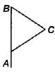
- b)
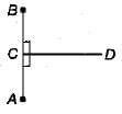
- c)
- d)
Correct answer is option 'A'. Can you explain this answer?
Which one of the following figures indicates the principle of traversing?
a)
b)
c)
d)

|
Varun Banerjee answered |
The correct answer is b.
The principles of traversing say that, a transverse should consist of a series of straight lines connected together to from an open or a closed polygon. The points lines are called transverse stations or transverse points.
The principles of traversing say that, a transverse should consist of a series of straight lines connected together to from an open or a closed polygon. The points lines are called transverse stations or transverse points.
Contour interval is- a)inversely proportional to the scale of the map
- b)directly proportional to the flatness of ground
- c)large for accurate works
- d)none of these
Correct answer is option 'A'. Can you explain this answer?
Contour interval is
a)
inversely proportional to the scale of the map
b)
directly proportional to the flatness of ground
c)
large for accurate works
d)
none of these
|
|
Nidhi Patel answered |
Contour interval is inversely proportional to the scale of the map
Contour interval refers to the vertical distance between contour lines on a topographic map. It is an important factor in representing the relief of the land and understanding its features. The contour interval is determined based on the scale of the map, and it plays a significant role in accurately depicting the elevation changes and slopes of the terrain.
Explanation:
The contour interval is inversely proportional to the scale of the map. This means that as the scale of the map decreases, the contour interval increases, and vice versa. The scale of a map refers to the ratio of distance on the map to the actual distance on the ground. For example, a map with a scale of 1:10,000 means that one unit on the map represents 10,000 units on the ground.
When the scale of the map is larger, more detail can be shown, and smaller features can be accurately represented. In this case, the contour interval can be smaller because there is more space to show the contour lines. On the other hand, when the scale of the map is smaller, less detail can be shown, and larger features have to be simplified. Consequently, the contour interval needs to be larger to accommodate the limited space on the map.
Example:
To better understand the concept, consider two maps of the same area but with different scales. Map A has a scale of 1:10,000, while Map B has a scale of 1:50,000. Map A will have more contour lines and a smaller contour interval compared to Map B. This is because Map A can show more detail due to its larger scale, allowing for a smaller contour interval and a more accurate representation of the terrain.
Significance:
It is important to choose an appropriate contour interval based on the scale of the map and the complexity of the terrain. If the contour interval is too large, the map may not accurately represent the elevation changes, and important features and slopes may be overlooked. Conversely, if the contour interval is too small, the map may become cluttered with excessive contour lines, making it difficult to interpret.
In conclusion, the contour interval is inversely proportional to the scale of the map. Understanding this relationship is crucial in creating accurate topographic maps that effectively represent the relief of the land.
Chapter doubts & questions for Theodolite, Compass & Traverse Surveying - Geomatics Engineering (Surveying) 2025 is part of Civil Engineering (CE) exam preparation. The chapters have been prepared according to the Civil Engineering (CE) exam syllabus. The Chapter doubts & questions, notes, tests & MCQs are made for Civil Engineering (CE) 2025 Exam. Find important definitions, questions, notes, meanings, examples, exercises, MCQs and online tests here.
Chapter doubts & questions of Theodolite, Compass & Traverse Surveying - Geomatics Engineering (Surveying) in English & Hindi are available as part of Civil Engineering (CE) exam.
Download more important topics, notes, lectures and mock test series for Civil Engineering (CE) Exam by signing up for free.
Geomatics Engineering (Surveying)
19 videos|59 docs|35 tests
|
|
© EduRev
|
Education Revolution
|


|


Signup on EduRev and stay on top of your study goals
10M+ students crushing their study goals daily