Environment and Ecology: September 2025 Current Affairs | Current Affairs & General Knowledge - CLAT PDF Download

Vultures and Public Health: Their Role in Preventing Future Pandemics
 Why in News?
Vultures, often underestimated in discussions about pandemic preparedness, are crucial to public health in South Asia. They serve as nature's most efficient waste managers, significantly reducing the spread of diseases.
Key Takeaways
- Vultures are essential for preventing zoonotic diseases by consuming carcasses quickly.
- India has seen a dramatic decline in vulture populations, which poses public health risks.
- The Central Asian Flyway links vulture populations and public health across regions.
- Conservation efforts for vultures are crucial for effective pandemic prevention strategies.
Additional Details
- Vultures' Role in Health Security: By swiftly consuming animal carcasses, vultures act as the first line of defense against potential disease outbreaks, significantly reducing the risks of pathogen spillover.
- Population Decline: India once had over 40 million vultures, but since the 1990s, their numbers have plummeted by more than 95%, primarily due to the veterinary drug diclofenac, leading to severe ecological and public health challenges.
- Central Asian Flyway (CAF): This migratory route connects breeding grounds in Central Asia with wintering areas in South Asia, serving as both a biodiversity and public health corridor.
- Conservation Challenges: Current conservation efforts are fragmented and underfunded, with threats such as electrocution and toxic drugs remaining largely unaddressed.
- Post-2025 Strategy: India’s upcoming vulture conservation strategy focuses on integrating wildlife, livestock, and health data, enhancing cross-sector collaboration, and empowering local communities.
India has a unique opportunity to demonstrate that biodiversity conservation can enhance public health security. By aligning health and environmental strategies, India can not only protect its vulture populations but also reduce the risks of future pandemics, showcasing effective global health practices.
What are ‘Planetary Boundaries’?
Why in News?
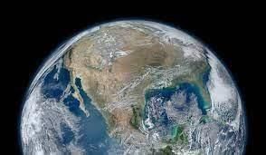
The Planetary Health Check (PHC) 2025 has issued a warning that seven out of nine planetary boundaries have been breached. This alarming report highlights the urgent need to address various human activities that are pushing Earth beyond its safe operating limits for the first time in over 11,000 years.
Key Takeaways
- The PHC report identifies seven breached planetary boundaries.
- Human activities such as fossil fuel combustion, deforestation, and unsustainable agriculture are significant contributors.
- Ocean acidification has crossed the safe zone for the first time.
Additional Details
- About Planetary Health Check (PHC): The PHC is a global scientific assessment that evaluates the health of the Earth’s systems by tracking ecological thresholds essential for maintaining habitability.
- Planetary Boundaries (PBs): This concept, introduced in 2009 by a team of scientists led by Johan Rockström, defines the safe operating space for humanity by establishing ecological thresholds that regulate Earth system stability and resilience.
- Significance: Crossing these boundaries poses a risk of irreversible environmental collapse.
Nine Planetary Boundaries
- Climate Change:
- Safe CO2 level: 350 ppm.
- Current level (2025): 423 ppm; radiative forcing at +2.97 W/m² (safe: +1.5 W/m²).
- Biosphere Integrity:
- Extinction rate: 100 E/MSY vs. safe limit of 10 E/MSY; biodiversity continues to decline.
- Land System Change:
- Global forest cover has decreased to 59% (previously 75%). All major terrestrial biomes are breached.
- Freshwater Change:
- Over 20% of global land shows significant deviations in streamflow (22.6%) and soil moisture (22%).
- Regions like the Indo-Gangetic Plain and North China basins are particularly at risk.
- Biogeochemical Flows:
- Excessive nitrogen (N) and phosphorus (P) use in agriculture is causing eutrophication and worsening dead zones in water bodies.
- Novel Entities:
- Introduction of plastics and synthetic chemicals exceeds the safe threshold, posing environmental risks.
- Ocean Acidification:
- Surface ocean acidity has increased by 30-40% since the industrial era, threatening marine life.
- Atmospheric Aerosol Loading:
- Current AOD difference is 0.063, below the safe threshold of 0.10, although it remains harmful to health.
- Stratospheric Ozone Depletion:
- Global ozone concentration is stable at 285-286 DU, continuing to recover, but new threats have emerged from rocket launches and satellite debris.
The concept of the "sixth mass extinction" often arises in discussions concerning mankind’s over-exploitation of natural resources, habitat destruction, pollution, and climate change. These factors are critical to understanding the current ecological crisis.
Ganga River is Drying Faster than in 1,300 Years: Report
 Why in News?
A recent study conducted by researchers from IIT Gandhinagar and the University of Arizona reveals alarming findings regarding the Ganga River, indicating that it is drying at a rate unprecedented in over a millennium.
Key Takeaways
- The Ganga River's streamflow has been reconstructed since 700 AD, utilizing tree-ring records and hydrological models.
- Historical droughts and famines, including the Bengal famine, were used to validate the study's findings.
- Between 1991 and 2020, multiple droughts persisted for 4-7 years, marking a rare occurrence in the last 1,300 years.
- The drought from 2004 to 2010 was the most severe in this period, with post-1990s drying being 76% more intense than the worst drought recorded in the 16th century.
Causes of Drying
- Weaker monsoons: Resulting from Indian Ocean warming and aerosol pollution.
- Groundwater over-extraction: This has significantly reduced the river's baseflow.
- Land-use change: Disrupting the natural recharge of the river system.
Implications
- The drying of the Ganga poses severe threats to agriculture and affects the livelihoods of approximately 600 million people.
- The health of Bay of Bengal ecosystems is at risk, along with the basin's contribution to 40% of India's GDP.
- This situation necessitates adaptive water management strategies to preserve this vital resource.
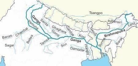
About the Ganga River
- Length: Approximately 2,525 km, making it the longest river in India.
- Origin: Begins at the Gangotri Glacier in Uttarakhand, at an elevation of 3,892 m, where it is known as Bhagirathi.
- Formation: Named Ganga at Devprayag, where it meets the Bhagirathi and Alaknanda rivers.
- Course: Flows through Uttarakhand, Uttar Pradesh, Bihar, Jharkhand, and West Bengal, before entering Bangladesh as the Padma, ultimately emptying into the Bay of Bengal through the Sundarbans Delta.
- Basin Area: Covers approximately 8.61 lakh sq. km, accounting for 26.4% of India's total area.
Tributaries
- Left bank: Ramganga, Gomti, Ghaghara, Gandak, Burhi Gandak, Koshi, and Mahananda.
- Right bank: Yamuna, Tons, Karamnasa, Sone, Punpun, Falgu, Kiul, Chandan, Ajoy, Damodar, and Rupnarayan.
Population and Cultural Importance
- Supports over 600 million people, making it the world's most densely populated river basin.
- Regarded as sacred in Indian culture and declared the National River in 2008.
Economic Role and Ecological Significance
- Central to agriculture, fisheries, and trade, contributing about 40% of India’s GDP.
- Home to diverse wildlife, including snow leopards, elephants, and the Ganga dolphin; contains significant reserves such as Corbett, Dudhwa, and the Sundarbans.
Conservation Efforts
- Ganga Action Plan (1985) and Namami Gange Programme (2014): Initiatives aimed at addressing persistent issues like pollution, over-extraction, and climate change.
Collapse of Atlantic Meridional Overturning Circulation (AMOC)
 Why in News?
A recent study has indicated that the collapse of the Atlantic Meridional Overturning Circulation (AMOC) is now considered a plausible scenario, rather than a low-probability event.
Key Takeaways
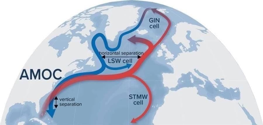
- The AMOC is an extensive system of ocean currents, a crucial component of the thermohaline circulation (THC), often referred to as the global ocean conveyor belt.
- It plays a vital role in transporting warm tropical surface waters northward and returning cooler waters southward as deep currents.
Additional Details
- Function of AMOC: It distributes heat and nutrients across the world's oceans, contributing significantly to global climate regulation.
- Reasons for AMOC Slowdown:
- Melting ice sheets in Greenland and the Arctic are adding freshwater to the ocean, which lowers the density of seawater, hindering the sinking process that drives circulation.
- A 2019 study noted that increased rainfall in the Indian Ocean affects rainfall patterns in the Atlantic, which may temporarily enhance AMOC due to saltier water sinking more quickly.
- Climate models project a potential weakening of 34-45% in AMOC by the year 2100 if global warming continues unabated.
- Consequences of AMOC Collapse:
- Europe and the North Atlantic could experience significant cooling.
- There would likely be a reduction in rainfall across Europe.
- Changes in El Niño–Southern Oscillation (ENSO) patterns may occur, impacting global weather systems.
- Expansion of sea ice in the Greenland–Iceland–Norwegian seas is anticipated.
- A long-term shift in rainfall patterns toward the southern tropical Atlantic could lead to increased climate variability and regional extremes.
In summary, the potential collapse of AMOC poses serious implications for global climate stability, highlighting the urgency of addressing climate change.
BS-VII Emission Norms

Why in News?
The Indian government is planning to introduce BS VII emission norms by 2026-27 to align the automobile sector with global standards, particularly focusing on reducing vehicular pollution.
Key Takeaways
- BS VII norms serve as India's equivalent to Euro 7 emission standards.
- They apply uniformly across various vehicle types, including petrol, diesel, hybrid, and electric vehicles.
- Introduction of On-Board Monitoring (OBM) for real-time tailpipe emissions tracking.
Additional Details
- Coverage: BS VII will cover cars, vans, buses, trucks, and all vehicle types to mitigate pollution.
- On-Board Monitoring (OBM): This system will enable real-time monitoring of emissions such as NOx, ammonia, and particulate matter.
- Non-Exhaust Regulation: For the first time, brake dust and tyre microplastics will be regulated under BS VII.
- EV Standards: New regulations will introduce battery safety, durability, and longevity standards to boost consumer confidence and reduce raw material use.
- Digital Safeguards: Vehicles will be protected against tampering to ensure compliance with emission limits.
- Testing Scope: BS VII expands testing beyond laboratory conditions to real driving scenarios.
Key Differences: BS6 vs BS7
- OBD vs OBM: BS6 utilized On-Board Diagnostics (OBD), while BS7 implements direct emission monitoring through OBM.
- NOx Standards: BS6 permitted 60 mg/km for petrol and 80 mg/km for diesel, whereas BS7 establishes a uniform limit of 60 mg/km.
- Exhaust Regulation: BS6 focused solely on exhaust emissions, while BS7 includes non-exhaust emissions from brakes and tyres.
- EV Inclusion: Unlike BS6, BS7 regulates aspects of electric vehicles including battery life and safety.
- Testing Conditions: BS6 relied on defined test cycles; BS7 utilizes broader real-world conditions.
- Technology Push: BS7 encourages automakers to develop advanced emission-control technologies.
- Cost Factor: Compliance with BS7 may increase vehicle costs, potentially leading to the discontinuation of older models.
History of Emission Norms in India
| Year / Period | Key Development |
|---|---|
| 1991 | Mass emission norms introduced for petrol vehicles. |
| 1992 | Mass emission norms introduced for diesel vehicles. |
| April 1995 | Mandatory catalytic converters in new petrol cars in metropolitan cities, introduction of unleaded petrol. |
| 2000 | Introduction of Euro I equivalent “India 2000” norms for passenger and commercial vehicles. |
| 2001 | Euro II equivalent Bharat Stage II norms introduced in major cities. |
| August 2002 | Auto Fuel Policy announced, outlining emission and fuel roadmap up to 2010. |
| April 2005 | Bharat Stage III norms implemented in 13 metro cities. |
| April 2010 | Bharat Stage IV norms adopted across the country, extended to 20 more cities by October 2014. |
| 2013 | Auto Fuel Policy 2025 submitted, outlining roadmap up to April 2017. |
| April 2020 | Direct leap to BS VI norms, skipping BS V due to severe pollution. |
| Upcoming (BS VII) | To align with Euro 7 standards, introducing stricter norms and coverage of brake & tyre emissions. |
India’s First Bamboo-Based Ethanol Plant Inaugurated in Assam
 Why in News?
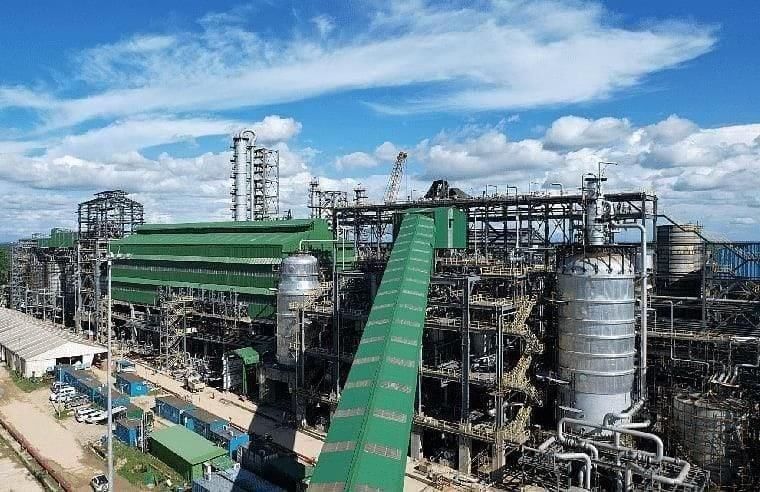
India inaugurated its first bamboo-based ethanol plant in Assam’s Golaghat, marking a significant advancement in green energy and rural development initiatives.
Key Takeaways
- The plant is a major step in India's transition to renewable energy.
- It utilizes bamboo, a non-food biomass, reducing competition with food crops.
- The project is expected to boost the rural economy of Assam significantly.
Additional Details
- Bamboo-Based Ethanol Production: Bamboo serves as the primary feedstock, undergoing processes such as pre-treatment, hydrolysis, fermentation, and distillation to produce ethanol.
- Co-Products: The facility will generate acetic acid, furfural, and food-grade liquid CO2, contributing to a zero-waste approach.
- Annual Production: The plant will process five lakh tonnes of bamboo to produce approximately 48,900 MT of ethanol, 11,000 MT of acetic acid, 19,000 MT of furfural, and 31,000 MT of liquid CO2.
- Economic Impact: It is projected to enhance Assam’s rural economy by around Rs. 200 crore annually.
- Energy Security: The project aims to reduce dependence on imported crude oil and promote energy self-sufficiency.
- Regional Growth: The plant aligns with the Make in Assam and Make in India initiatives, enhancing Assam's industrial capabilities.
The inauguration of this bamboo-based ethanol plant not only represents a technological innovation but also creates economic opportunities for rural communities, reinforcing India's commitment to sustainable development and energy security.
Green Credit Programme (GCP) - Revised Rules for Tree Plantation
Why in News?
The Union Environment Ministry has recently introduced a new methodology for awarding green credits under the Green Credit Programme (GCP), replacing the previous framework. This revision includes significant changes regarding eligibility, time frames, and the use of credits.
Key Takeaways
- The GCP was launched in November 2023 during the UN Climate Conference (COP28) in Dubai.
- The programme aims to promote voluntary environmental protection actions, including tree plantation and waste management.
- New rules shift focus from mere tree counting to emphasizing long-term plantation health and survival.
Additional Details
- Awarding of Credits: The previous methodology required a minimum density of 1,100 trees per hectare within two years. This was criticized for neglecting survival rates. The new methodology allows credits to be earned after five years of restoration activities on degraded land, focusing on vegetation status and survival rates.
- Tradability of Credits: Under the revised rules, tree plantation credits are non-tradable and non-transferable, except between a holding company and its subsidiaries.
- Permissible Uses of Green Credits: Credits can be exchanged for compensatory afforestation obligations or to meet corporate social responsibility requirements, but will cease after such exchanges.
- The credits may also be utilized for reporting under environmental, social, and governance (ESG) indicators.
The revised Green Credit Programme represents a significant shift from superficial tree-planting initiatives to a more sustainable approach focused on ecological restoration. This change is expected to enhance India's climate resilience, improve biodiversity, and bolster corporate accountability in environmental stewardship.
Pollution in Indian Rivers: CPCB Report, 2023
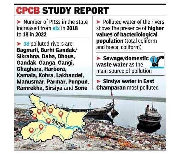
Why in the News?
The Central Pollution Control Board (CPCB) has recently published its assessment for the years 2022–2023 regarding the health of rivers in India, highlighting critical issues surrounding river pollution.
Key Takeaways
- The CPCB assessment reveals a marginal decline in unfit bathing locations, from 815 in 2022 to 807 in 2023.
- A total of 296 polluted river stretches were identified across 271 rivers, down from 311 stretches in 279 rivers the previous year.
Additional Details
- About Central Pollution Control Board (CPCB):
- Established as a statutory body in September 1974 under the Water (Prevention and Control of Pollution) Act, 1974.
- Later expanded its mandate to include powers under the Air (Prevention and Control of Pollution) Act, 1981.
- Acts as the technical arm of the Ministry of Environment, Forest & Climate Change (MoEFCC).
- Principal Functions:
- Water pollution control: Aims to promote cleanliness in streams and wells by preventing and controlling pollution.
- Data Management: Collects and disseminates technical and statistical data on air and water pollution.
- Biological Oxygen Demand (BOD):
- Defines the amount of dissolved oxygen required by microbes to decompose organic matter.
- Healthy rivers have a BOD of less than 3 mg/L, whereas rivers with BOD greater than 3 mg/L are considered unfit for bathing.
In summary, the CPCB's findings emphasize the ongoing challenges of pollution in Indian rivers and the need for continued efforts to improve water quality across the nation.
Data Shows Seas Rising Faster Around Maldives, Lakshadweep Than Believed
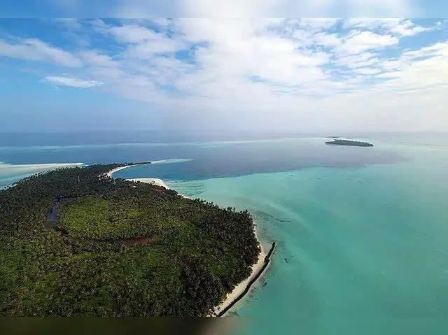
Why in News?
The issue of rising sea levels has gained significant attention due to its severe implications for ecosystems, economies, and human settlements, particularly for vulnerable island nations such as the Maldives and Lakshadweep. Recent research using coral microatolls indicates that sea levels in the Indian Ocean began rising rapidly as early as the 1950s, challenging previous assumptions based on satellite and tide-gauge data.
Key Takeaways
- Coral microatolls provide a natural record of sea-level changes.
- Sea-level rise in the Indian Ocean has been accelerating since the late 1950s.
- Vulnerable island nations face significant risks due to rising sea levels.
Additional Details
- Coral Microatolls: These are disk-shaped colonies of coral that stop growing upwards when they reach the lowest tide level, providing a natural record of sea-level changes over time. Research conducted at the Mahutigalaa reef in the Huvadhoo Atoll of the Maldives measured a Porites microatoll from 1930 to 2019, revealing a significant rise.
- Accelerated Sea-Level Rise:Data indicates a rise of 0.3 meters over the past 90 years, with varying rates of increase:
- 1930-1959: 1-1.84 mm/year
- 1960-1992: 2.76-4.12 mm/year
- 1990-2019: 3.91-4.87 mm/year
- Climate Variability: The growth patterns of corals were affected by climatic events such as El Niño and the Indian Ocean Dipole, highlighting the influence of climate variability on marine ecosystems.
- Regional Significance: The Indian Ocean is warming at a rate higher than the global average, which contributes to accelerated sea-level rise and highlights the need for better monitoring in this region.
- Adaptation Strategies: The findings stress the importance of understanding the timing and magnitude of sea-level rise for effective coastal planning and disaster preparedness.
The revelation that sea-level rise in the Maldives and Lakshadweep began decades earlier than previously thought serves as a crucial alert for policymakers and local communities. As the Indian Ocean continues to warm, proactive measures and international cooperation will be essential for the survival of low-lying nations facing existential threats.
Pugad Island: An Existential Threat
Why in News?
The Philippine island of Pugad, located in Manila Bay, is confronting severe challenges due to rising sea levels and rapid land subsidence, which threaten to submerge homes and disrupt the livelihoods of its residents.
Key Takeaways
- Pugad Island is a small, 7-hectare island situated at the mouth of the Angat–Pampanga River Delta.
- The island falls under the jurisdiction of Hagonoy municipality in Bulacan province, Philippines.
- It has a population of approximately 1,636 to 2,056 residents living in a clustered village with about 384 houses.
- The community primarily relies on fishing and aquaculture for their livelihoods.
Additional Details
- Living Conditions: Residents live in houses primarily constructed from bamboo and old metal sheets, facing challenges such as poor sanitation and minimal healthcare facilities.
- Flooding Challenges: The island regularly experiences flooding from high tides and monsoon seasons, exacerbated by land subsidence at a rate of 11 cm per year and sea-level rise, which is three times the global average.
- Environmental Hazards: The loss of mangroves, urban encroachment, and exposure to typhoons significantly increase the risks of disaster and displacement for the island's inhabitants.
In summary, Pugad Island is at a critical juncture, facing environmental challenges that threaten its very existence and the well-being of its residents. Urgent measures are needed to address these issues and protect the community from further risks.
Future of Indian Cities - Building Climate-Resilient and Inclusive Urban Growth

Why in News?
Cities are pivotal to India's future, projected to generate 70% of new jobs by 2030. By 2050-2070, India's urban population is expected to approach 1 billion, with megacities growing larger than entire countries. This rapid urbanization necessitates a strategic approach to designing infrastructure, housing, and services that are capable of supporting growth while addressing vulnerabilities to climate change.
Key Takeaways
- India will require 144 million new homes by 2070, necessitating substantial infrastructure development.
- Urban areas face significant flooding risks, which could lead to economic losses of $5 billion by 2030 and $30 billion by 2070.
- Extreme heat is exacerbated by the urban heat island effect, leading to dangerously high nighttime temperatures.
- Investment in climate-resilient infrastructure is projected to be around $10.95 trillion by 2050-2070.
Additional Details
- Urban Infrastructure Needs: By 2070, India will need more than double its current housing stock along with transportation systems and municipal services that can handle the influx of residents. The new infrastructures must be designed to withstand climate change impacts, such as floods, heatwaves, and other extreme weather events.
- Transportation Challenges: Approximately 25% of urban roads are vulnerable to flooding, where even minimal inundation can disrupt over 50% of city transport systems. Solutions like flood risk mapping, improved drainage, and alternative routes are essential for maintaining mobility.
- Climate Change Risks: A significant portion of urban dwellers is at risk of pluvial flooding, necessitating an integrated approach that includes flood warning systems and nature-based solutions.
- Extreme Heat Measures: Cities can mitigate the urban heat island effect by increasing tree cover, implementing cool roofs, and adjusting working hours for outdoor laborers.
- Way Forward: Modernizing municipal services and fostering collaboration between government, citizens, and the private sector is crucial for sustainable urbanization and improving living standards.
In conclusion, India's cities face a critical juncture of rapid growth and significant climate challenges. Proactive investments in climate-resilient, inclusive, and sustainable urban planning are essential for safeguarding lives, reducing economic losses, and unlocking the demographic and entrepreneurial potential of the nation. Building compact, resilient, and efficient cities is not only an environmental necessity but also a strategic imperative for India's economic future.
The Making of an Ecological Disaster in the Nicobar
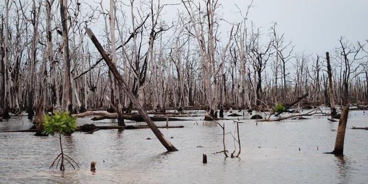
Why in News?
The Great Nicobar mega-infrastructure plan has garnered criticism for its potential to displace indigenous communities and significantly damage a unique ecosystem in India. With an estimated cost of ₹72,000 crore, this project raises serious concerns about environmental sustainability and social justice.
Key Takeaways
- The project threatens the existence of indigenous groups, specifically the Nicobarese and the Shompen.
- It undermines constitutional protections and environmental laws, leading to potential ecological disaster.
- Construction in a seismically active zone raises serious safety concerns for human lives.
Additional Details
- Displacement of Indigenous Communities: The Nicobarese and Shompen face significant threats to their existence due to this project. The Nicobarese have already suffered displacement from their ancestral lands since the 2004 tsunami, and the Shompen are at risk of losing their cultural and economic continuity as their resources are compromised.
- Bypassing Constitutional Protections: Required consultations with the National Commission for Scheduled Tribes have not occurred, reflecting a disregard for legal processes.
- Environmental Safeguards: The project infringes on the Coastal Regulation Zone 1A, where construction is prohibited to protect vital ecosystems such as coral reefs and turtle nesting grounds.
- Ecological Devastation: The plan threatens to destroy between 8.5 lakh to 32-58 lakh trees and promotes compensatory afforestation that is ecologically unsuitable.
- Seismic Vulnerability: Situated in a region prone to earthquakes, the potential for disaster increases significantly, as demonstrated by past seismic events such as the 2004 tsunami.
The situation surrounding the Great Nicobar project highlights a significant conflict between development ambitions and the need for ecological preservation and social justice. The survival of indigenous tribes and the health of unique ecosystems are at stake, necessitating urgent action and advocacy against such projects.
Biodiversity Beyond National Jurisdictions (BBNJ) Agreement
Why in News?
The Ministry of Earth Sciences has established a 12-member committee, chaired by SC lawyer Sanjay Upadhyay, tasked with drafting a national law to protect India's maritime and economic interests in accordance with the 2023 High Seas Treaty, known as the BBNJ Agreement.
Key Takeaways
- The BBNJ Agreement is an international treaty under the United Nations Convention on the Law of the Sea (UNCLOS).
- It aims for the conservation and sustainable use of marine biodiversity in international waters, which cover approximately 64% of the world’s oceans.
Additional Details
- Scope of Provisions:
- Establishment of Marine Protected Areas (MPAs) in the high seas.
- Regulation of seabed mining and other extractive activities.
- Ensuring fair and equitable sharing of benefits from marine genetic resources.
- Mandatory environmental impact assessments (EIAs) prior to major projects.
- Utilization of both scientific and traditional knowledge, guided by the precautionary principle.
- Relation to UNCLOS:This agreement will be the third implementing agreement of UNCLOS, alongside:
- 1994 Part XI Implementation Agreement: Focused on seabed mineral resources.
- 1995 UN Fish Stocks Agreement: Concerned with the conservation of migratory fish stocks.
- Adoption & Status:
- Agreed upon in March 2023, it will be open for signature for two years starting from September 2023.
- It will enter into force 120 days after the 60th ratification (currently ratified by 55 countries).
Swachh Vayu Survekshan, 2025
Why in News?
Indore has been recognized once again as the cleanest city in India, achieving the top position among cities with a million-plus population in the Swachh Vayu Survekshan 2025.
Key Takeaways
- Indore ranks 1st among million-plus cities, improving from 6th place in 2024.
- Other cities in the top rankings include Jabalpur, Agra, and Surat.
Additional Details
- Overview: The Swachh Vayu Survekshan (SVS) is an annual survey conducted by the Ministry of Environment, Forest and Climate Change (MoEFCC) under the National Clean Air Programme (NCAP).
- Objective: It aims to foster healthy competition among cities and accelerate the implementation of air quality improvement measures.
- Coverage: The survey includes 130 cities categorized into three groups based on population size: million-plus, 3–10 lakh, and under 3 lakh.
- Parameters: Cities are evaluated on 8 factors, including road dust mitigation, solid waste management, and particulate matter (PM10/PM2.5) reduction.
- Methodology: The assessment employs a multi-tier evaluation that focuses on both on-ground actions and measurable outcomes.
In the 2025 findings, Indore topped the list, while cities like Jabalpur and Agra followed closely. Additionally, the survey revealed that 103 out of 130 cities have reduced PM10 levels since 2017-18, with 64 cities achieving at least a 20% reduction. However, only 22 cities met the national standard of 60 µg/m³ for PM10 concentration.
Centre Approves Independent Class of Environment Auditors
Why in News?
The Environment Ministry has introduced the Environment Audit Rules, 2025, which establish a new category of independent “environment auditors.” These accredited private agencies, akin to chartered accountants, will be authorized to inspect and verify compliance with environmental laws for various projects. Their responsibilities will complement those of State Pollution Control Boards (SPCBs) by conducting environmental impact assessments and ensuring adherence to best practices in pollution prevention and control.
Key Takeaways
- The new rules aim to enhance India’s commitment to sustainable governance and ease of doing business.
- Private agencies will now play a critical role in environmental compliance monitoring.
- The initiative addresses existing gaps in the monitoring system due to limited resources of current regulatory bodies.
Additional Details
- Need for the Rules: Existing monitoring is hampered by limited manpower and resources, leading to ineffective enforcement by the Central Pollution Control Board (CPCB) and State PCBs. The new rules aim to address these shortcomings.
- Main Features of the Rules:
- Certification and Registration: Environment auditors will need to be certified and registered through the Environment Audit Designated Agency (EADA).
- Random Assignment of Auditors: Auditors will be assigned randomly to prevent bias and conflicts of interest.
- Responsibilities: Registered auditors will verify compliance, conduct sampling and analysis, and ensure adherence to various environmental laws.
- Self-Compliance Verification: Auditors will also verify self-reported compliance from project proponents.
- Key Stakeholders:
- Certified Environment Auditor (CEA): Qualified through Recognition of Prior Learning or a National Certification Examination.
- Registered Environment Auditor (REA): Certified professionals officially licensed to perform audits.
- Environment Audit Designated Agency (EADA): Responsible for certification, registration, oversight, and maintaining an online registry.
- MoEFCC: Oversees implementation and provides guidelines.
- CPCB, SPCBs, and Regional Offices: Continue inspections and assist in enforcing the new rules.
The introduction of the Environment Audit Rules, 2025 marks a significant reform in India’s environmental governance. By expanding the scope of monitoring to include private agencies, the rules aim to enhance transparency and accountability in environmental compliance. However, challenges remain at the grassroots level, necessitating a focus on empowering local staff for effective enforcement and ensuring that core monitoring functions are upheld. The success of this framework will ultimately depend on integrating these independent audits with existing compliance systems and strengthening local-level enforcement.
Cold Desert Biosphere Reserve – UNESCO Recognition
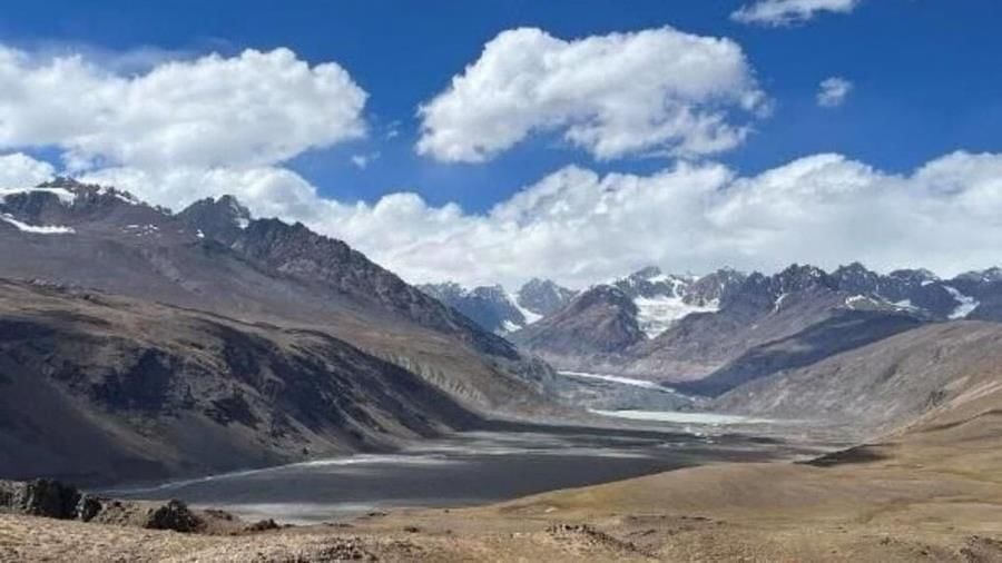 Why in News?
The Cold Desert Biosphere Reserve, located in Himachal Pradesh, has recently been designated as part of UNESCO's World Network of Biosphere Reserves (WNBR). This recognition marks India’s 13th biosphere reserve to be included in the global list, acknowledging the ecological and cultural significance of this fragile Trans-Himalayan ecosystem.
Key Takeaways
- India's Cold Desert Biosphere Reserve spans 7,770 sq. km in the Lahaul-Spiti district.
- This designation underscores the importance of biodiversity protection and sustainable development in the region.
- UNESCO's recognition aligns with global efforts to safeguard vulnerable ecosystems facing climate change and tourism pressures.
Additional Details
- Geographical Spread: The reserve covers various landscapes, including windswept plateaus, glacial valleys, alpine lakes, and high-altitude deserts, situated at altitudes ranging from 3,300 to 6,600 meters.
- Biodiversity: The area is home to 732 vascular plant species, including 30 endemics and 47 medicinal herbs used in traditional healing practices. Notable fauna includes the snow leopard, Himalayan ibex, and several bird species like the golden eagle.
- The reserve is inhabited by around 12,000 residents who engage in traditional pastoralism, yak herding, and small-scale farming.
- The community maintains ancient Tibetan herbal medicine practices, influenced by local Buddhist monasteries.
This UNESCO designation not only elevates the Cold Desert to international prominence but also emphasizes the need for cooperation in conservation efforts, eco-tourism, and climate research. The recognition signals a commitment to integrating ecological preservation with community development, showcasing India's rich cultural and biological heritage.
Bihar Adds 2 More Wetlands to Ramsar List
Why in News?
India has recently added two wetlands in Bihar — Gokul Jalashay located in Buxar district and Udaipur Jheel in West Champaran district — to the prestigious Ramsar list of Wetlands of International Importance.
Key Takeaways
- India's Ramsar sites have increased to a total of 93, solidifying its position as a leader in Asia and the third globally.
- The number of Ramsar sites in India has expanded significantly from 26 in 2012 to 93 in 2025.
Additional Details
- India's Ramsar Sites: With the new additions, India now has 93 Ramsar sites, covering an area of approximately 13.6 lakh hectares, with 51 sites added since 2020.
- Global Context: There are currently 2,544 Ramsar sites worldwide, with the UK having the highest number at 176 sites, followed by Mexico with 144 sites.
- Gokul Jalashay: An oxbow lake spanning 448 hectares on the southern edge of the Ganga River, it acts as a flood buffer and supports over 50 bird species while providing livelihoods through fishing, farming, and irrigation.
- Udaipur Jheel: A 319-hectare oxbow lake that is part of the Udaipur Wildlife Sanctuary ecosystem, formed by the Gandaki River. This wetland enhances ecological connectivity and supports migratory birds along the Central Asian Flyway.
The Ramsar Convention, established on February 2, 1971, in Ramsar, Iran, aims to promote the conservation and sustainable use of wetlands. As of 2025, it has 173 member countries, including India, which joined in 1982. The first Ramsar site in India was Chilika Lake, Odisha, designated in 1981. The growth of Ramsar sites in India is notable, with Tamil Nadu leading with the highest number of sites (20), followed by Uttar Pradesh (10). Furthermore, about 10% of India's total wetland area is under Ramsar listing.
World Wetlands Day is celebrated annually on February 2nd, with the theme for 2025 being “Protecting Wetlands for Our Common Future.”
Criteria for Declaration
A wetland can be declared a Ramsar site if it meets at least one of the following criteria:
- It has unique or representative wetland types.
- It supports vulnerable, endangered, or endemic species.
- It provides critical habitat for waterfowl, particularly during migration.
- It contains significant ecological, botanical, zoological, or hydrological features.
- It plays a role in biodiversity conservation and scientific research.
- It provides ecosystem services such as flood control, groundwater recharge, and water purification.
- It holds cultural, spiritual, or recreational significance.
- It ensures sustainable livelihoods for local communities.
- It faces threats requiring international cooperation.
In conclusion, the inclusion of these two new wetlands in Bihar highlights India's commitment to wetland conservation and its growing role in global environmental efforts.
Topography and Climate Change Fuel Himalayan Rains
d various districts in Uttarakhand have recently experienced heavy rainfall, resulting in landslides, swollen rivers, and at least 15 fatalities. Over the past month, Uttarakhand and Himachal Pradesh have faced multiple instances of cloudbursts, flash floods, and mudslides, alongside disruptions to communication networks. Although such events are typical during monsoon seasons, their increasing frequency and severity have raised significant concerns regarding safety and resilience in the Himalayan region.
Key Takeaways
- Increased rainfall in hilly regions is linked to geographical factors and climate change.
- Hilly areas face greater disaster risks due to topography that exacerbates the effects of heavy rainfall.
Additional Details
- Why Hilly Regions Receive More Rainfall: This monsoon season, the northwestern region has recorded an unusual rainfall surplus of 34% in August and over 67% above normal in early September. The geography of hilly areas like the western Himalayas causes rising air to form steep clouds, leading to heavy local precipitation. For example, Udhampur in J&K reported 630 mm of rain in just 24 hours, comparable to Rajkot's annual rainfall.
- Greater Disaster Risks: Unlike plains, where heavy rainfall typically drains into rivers, mountainous regions experience landslides and flash floods. Recent incidents in areas such as Mandi and Kullu demonstrate the devastating impacts of such weather events. Not all cloudbursts result in disasters, as the local conditions significantly influence the outcomes.
- Climate Change Influence: Recent trends indicate a southward shift of western disturbances, which interact with monsoon currents. This shift is associated with more frequent extreme rainfall events and prolonged dry spells, further complicated by factors such as Arctic sea ice melting.
- Cloudburst Vulnerability: The Himalayas experience intense localized downpours due to the interaction of tropical monsoon winds and mid-latitude westerlies. Climate change exacerbates this vulnerability by altering jet streams and increasing moisture levels, leading to longer-lasting storms and heavier rainfall.
- Forecasting Challenges: Current cloudburst forecasting relies on various technologies, including Doppler Weather Radars, satellites, and numerical weather prediction models. However, limitations in coverage and resolution, particularly in rugged topography, hinder accurate predictions. Enhanced observation networks and improved modeling techniques are essential for better accuracy.
In summary, the increasing severity of rainfall and associated disasters in the Himalayan region is a pressing concern influenced by both topographical and climatic factors. Enhanced forecasting methods and a better understanding of these dynamics are crucial for mitigating future risks.
|
98 videos|939 docs|33 tests
|
FAQs on Environment and Ecology: September 2025 Current Affairs - Current Affairs & General Knowledge - CLAT
| 1. What are the ‘Planetary Boundaries’ and why are they important for environmental health? |  |
| 2. How do vultures contribute to public health and the prevention of pandemics? | |
| 3. What are the implications of the drying of the Ganga River on local ecosystems and communities? | |
| 4. What is the Atlantic Meridional Overturning Circulation (AMOC) and why is its collapse a concern? | |
| 5. How does the Green Credit Programme (GCP) promote tree plantation and environmental sustainability? | |


Extra Questions
,video lectures
,shortcuts and tricks
,Semester Notes
,MCQs
,Objective type Questions
,study material
,Environment and Ecology: September 2025 Current Affairs | Current Affairs & General Knowledge - CLAT
,Sample Paper
,practice quizzes
,Important questions
,mock tests for examination
,ppt
,Previous Year Questions with Solutions
,past year papers
,Environment and Ecology: September 2025 Current Affairs | Current Affairs & General Knowledge - CLAT
,Free
,Environment and Ecology: September 2025 Current Affairs | Current Affairs & General Knowledge - CLAT
,Viva Questions
,Summary
,Exam
;


Environment and Ecology: September 2025 Current Affairs Free PDF Download
Importance of Environment and Ecology: September 2025 Current Affairs
Environment and Ecology: September 2025 Current Affairs Notes
Environment and Ecology: September 2025 Current Affairs CLAT Questions
Study Environment and Ecology: September 2025 Current Affairs on the App
|
© EduRev
|
Education Revolution
|


|


within 7 days!