Geography: September 2025 Current Affairs | Current Affairs: Daily, Weekly & Monthly - CLAT PDF Download

‘Blood Moon’ and Lunar Eclipse
 Why in News?
On 8th September, a stunning Blood Moon was visible across Asia, Australia, and parts of Africa, marking a significant total lunar eclipse event.
Key Takeaways
- A Blood Moon occurs during a total lunar eclipse when the Earth is positioned directly between the Sun and the Moon.
- The event highlights the phenomena of eclipses and their types, such as total, partial, and penumbral.
Additional Details
- Lunar Eclipse:This phenomenon transpires when the Earth blocks sunlight from reaching the Moon. There are three types of lunar eclipses:
- Total Eclipse: The Moon completely passes through the Earth's umbra, resulting in a full shading.
- Partial Eclipse: Only a portion of the Moon enters the umbra, leading to a partial shading effect.
- Penumbral Eclipse: The Moon moves through the Earth's penumbra, causing a subtle dimming of its brightness.
- The frequency of lunar eclipses is generally 2-4 times a year, with visibility varying by location.
- Why Don’t Lunar Eclipses Occur Every Month? Lunar eclipses are infrequent due to the Moon’s orbital tilt of about 5 degrees relative to the Earth's orbit, leading to misalignment during most full moons.
What is Blood Moon?
- Meaning: The term "Blood Moon" refers to the reddish hue of the Moon observed during a total lunar eclipse.
- Cause: This coloration is due to Rayleigh scattering in the Earth's atmosphere, where shorter wavelengths of light scatter away, allowing longer wavelengths like red and orange to light up the Moon.
- Colour Intensity: The intensity of the red shade can vary based on atmospheric conditions, such as the presence of dust or volcanic ash.
- Historical Insight: Records of Blood Moons from medieval times have been used to identify volcanic eruptions between 1100-1300 CE, corroborated by a 2023 study from the University of Geneva.
Significance
- Scientific: Blood Moons serve as natural indicators of atmospheric composition, aiding in the modeling of planetary atmospheres.
- Historical/Environmental: They provide valuable evidence of past volcanic events and climate changes.
- Cultural: Blood Moons are often associated with myths and superstitions, though they pose no scientific harm.
- Public Engagement: These celestial events are widely followed, fostering interest and awareness in astronomy.
In summary, the occurrence of a Blood Moon during a total lunar eclipse not only captivates audiences worldwide but also contributes to scientific understanding and cultural narratives surrounding astronomical phenomena.
Cauvery River Dispute
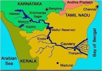 Why in News?
The ongoing dispute regarding the Cauvery River has gained attention as the Chief Minister of Karnataka announced that sufficient rainfall allows for the release of water to Tamil Nadu. This statement emphasizes the significance of the Mekedatu Dam in maintaining water balance and generating clean energy.
Key Takeaways
- The Cauvery River flows approximately 800 km through Karnataka and Tamil Nadu before emptying into the Bay of Bengal.
- Legal disputes regarding water sharing date back to colonial times and are influenced by the Cauvery Water Disputes Tribunal's findings.
- The Mekedatu Dam project is controversial, with Karnataka asserting its benefits for both states while Tamil Nadu raises concerns over downstream water availability.
Additional Details
- Origin & Course: The Cauvery River originates at Talakaveri in the Brahmagiri range of Kodagu, Karnataka, and flows through Karnataka and Tamil Nadu.
- Catchment Area: The river's catchment area covers Karnataka, Tamil Nadu, Kerala, and Puducherry.
- Colonial Origins: The dispute began in 1892, with the 1924 Agreement lasting until its expiration in 1974.
- The interim phase included the formation of the Cauvery River Authority in 1998, which issued temporary orders to manage the water allocation.
- The final award by the Cauvery Water Disputes Tribunal in 2013 allocated specific water shares: Tamil Nadu 419 TMC, Karnataka 270 TMC, Kerala 30 TMC, and Puducherry 7 TMC.
- Karnataka’s Obligation: In normal years, Karnataka is required to release 177.25 TMC of water to Tamil Nadu.
- Challenges arise during weak monsoon periods, often invoking a distress formula for water distribution.
- Legal Basis: The dispute is governed by Article 262 of the Inter-State River Water Disputes Act of 1956.
The Mekedatu Dam project, located at the confluence of the Cauvery and Arkavathi rivers near Kanakapura, aims to regulate water flow and generate hydropower. However, it faces opposition from Tamil Nadu, which fears reduced water availability downstream. The project currently requires clearance from both the Central government and Tamil Nadu to proceed.
In a related question from UPSC 2022, it was asked which river created the Gandikota canyon in South India, with options including Cauvery, Manjira, Pennar, and Tungabhadra.
Erra Matti Dibbalu
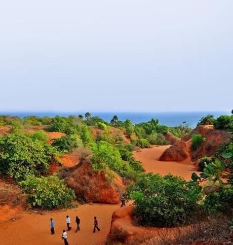 Why in News?
This newscard features an excerpt from a photograph published in 'The Hindu', highlighting the significance of Erra Matti Dibbalu.
Key Takeaways
- Location: Situated between Visakhapatnam and Bheemunipatnam in Andhra Pradesh, extending 5 km along the coast.
- Geological Heritage: Recognized as one of the 34 National Geological Heritage Monument Sites of India by the Geological Survey of India (GSI).
- Formation Period: Formed approximately 12,000 to 18,500 years ago due to tectonic activity, sea-level changes, monsoonal variability, and climatic shifts.
Additional Details
- Meaning: The term "Erra Matti" translates to "red soil" and "Dibbalu" means mounds, which accurately describes the reddish sand dunes found here.
- Geological Composition: Mainly derived from Khondalite rocks of the Eastern Ghats, with the red coloration attributed to the oxidation of iron-rich sediments.
- Significance: Serves as a paleo-environment indicator, providing insights into climate change, sea-level fluctuations, and coastal evolution during the late Quaternary period.
- Archaeological Importance: Artifacts from the Mesolithic and Neolithic periods have been discovered, along with sediment layers dating back to the Late Pleistocene epoch.
- Conservation Status: Declared a National Geo-heritage Monument in 2016 and included in UNESCO's Tentative List of World Heritage Sites in 2025 for global recognition and protection.
- Unique Landscape: Characterized by badland topography that includes sand dunes, buried channels, gullies, and dendritic drainage patterns.
- Rare Formation: One of only three similar red sand dune systems in the world, along with the Teri dunes in Tamil Nadu and a site in Sri Lanka.
In summary, Erra Matti Dibbalu is a significant geological and archaeological site, recognized for its unique landscapes and valuable insights into historical climate changes. Its conservation as a national geo-heritage monument emphasizes the need for protection and study of such unique natural formations.
South-west Monsoon: Its Onset and Retreat
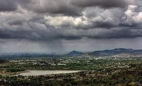
Why in the News?
The India Meteorological Department (IMD) announced that the southwest monsoon commenced its earliest withdrawal in a decade on September 14 from western Rajasthan, which is three days ahead of the typical date of September 17.
Key Takeaways
- The southwest monsoon officially begins on June 1 over Kerala and covers the entire country by mid-July.
- The monsoon is crucial for approximately 75% of India's annual rainfall, significantly impacting Kharif crops, water storage, and ecosystems.
Additional Details
- Mechanism of Monsoon Onset: The Indian landmass heats more rapidly than the Indian Ocean, leading to low pressure over northwestern India that attracts moist winds.
- Mascarene Highs: Located near the Mascarene Islands, these high-pressure systems strengthen during May and June, pushing strong cross-equatorial winds from the southeastern Indian Ocean towards India.
- ITCZ (Intertropical Convergence Zone) Shift: The ITCZ moves northwards over the Ganga plains, which helps anchor the monsoon trough.
- Tibetan Plateau Heating: This acts as an elevated heat source, deepening the low-pressure area essential for monsoon formation.
- Jet Stream Influence: The Subtropical Westerly Jet shifts north of the Himalayas, allowing the monsoon trough to develop, while the Tropical Easterly Jet enhances moisture flow.
- Local Triggers: Orographic uplift in regions like the Western Ghats and Indo-Gangetic plains results in heavy rainfall.
The withdrawal of the monsoon is a gradual process, typically completed by mid-October. The IMD sets September 30 as the official end of the southwest monsoon season, which is crucial for the sowing of Rabi crops.
Influencing Factors for Monsoon Retreat
- Seasonal Cooling: The reduced solar heating in September weakens the low pressure over the land.
- Pressure Gradient Reversal: High pressure returns over northwestern India, collapsing the southwest winds.
- ITCZ Shift: The ITCZ moves back south towards the equator, reversing wind patterns.
- Jet Stream Role: The Tropical Easterly Jet weakens, and the return of westerlies pushes out moist winds.
- Topography & Seas: Coastal and mountainous areas may still receive residual post-monsoon showers as the southern hemisphere winter ends.
Climatic Phenomena Affecting the Indian Monsoon
- ENSO (El Niño–Southern Oscillation):This phenomenon originates in the equatorial Pacific Ocean and affects the Pacific Walker Circulation (PWC).
- El Niño Years: Warming of eastern and central Pacific waters weakens the Walker circulation, reducing moisture-laden winds towards India, often leading to weak or deficient monsoons.
- La Niña Years: Cooling of Pacific waters strengthens the Walker circulation, enhancing moisture flow into India and typically resulting in above-normal rainfall.
- ENSO acts as a "remote controller" influencing the strength of Indian monsoon winds.
- Indian Ocean Dipole (IOD):A seesaw pattern of sea surface temperatures in the Indian Ocean.
- Positive IOD: Warmer western Indian Ocean strengthens cross-equatorial winds, leading to good rainfall.
- Negative IOD: Cooler western Indian Ocean weakens monsoon winds, resulting in reduced rainfall.
- IOD can amplify or cancel out the effects of ENSO.
- ENSO–IOD Interaction:The outcomes of the monsoon depend on the interaction between ENSO and IOD.
- El Niño + Positive IOD: IOD can mitigate El Niño's negative impact.
- El Niño + Negative IOD: This combination often results in severe droughts.
- La Niña + Positive IOD: Both factors can lead to heavy rainfall and flood risks.
The Madden–Julian Oscillation (MJO) is another key factor, influencing intra-seasonal variability by determining periods of heavy rainfall and dry breaks.
Super Typhoon Ragasa
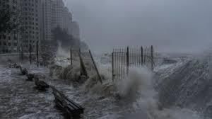
Why in News?
China is preparing to evacuate approximately 400,000 people in anticipation of the landfall of Super Typhoon Ragasa. This action highlights the severe impact and threat posed by the approaching storm.
Key Takeaways
- Super Typhoon Ragasa is a significant tropical cyclone forming in the Western Pacific Ocean and the China Sea.
- It is characterized by sustained winds that can exceed 240 km/h, leading to potential destruction.
Additional Details
- About Typhoon & Super Typhoon: These are tropical cyclones that typically develop over warm ocean waters, specifically when sea temperatures exceed 27°C.
- Formation: They form when warm, moist air rises, creating a low-pressure system with spiraling winds. According to the US Joint Typhoon Warning Center (JTWC), a super typhoon is defined by sustained winds of 240 km/h or more.
- Structure:
- Eye: The calm center of the storm.
- Eyewall: The area with the strongest winds and heaviest rainfall.
- Spiral Rainbands: Bands of rain and showers that extend outward from the storm.
- Impacts: Super typhoons can lead to storm surges, coastal flooding, landslides, and significant destruction to infrastructure, agriculture, and homes.
Understanding tropical cyclones is crucial as they are large low-pressure systems that form over warm oceans and are marked by rotating winds, heavy rainfall, and storm surges.
- They typically develop when ocean temperatures are above 27°C and moist air rises, releasing latent heat to fuel convection.
- The Coriolis force drives their rotation, resulting in anticlockwise movement in the Northern Hemisphere and clockwise in the Southern Hemisphere, leading to distinct structural features such as the eye, eyewall, and rainbands.
- Regional names for these storms vary: they are called typhoons in the Pacific, hurricanes in the Atlantic and Caribbean, and tropical cyclones in the Indian Ocean. The frequency of these events is common in Southeast Asia due to warm Pacific waters, as well as the influences of El Niño/La Niña cycles and climate change.
- The consequences of such storms can include loss of life, property damage, flooding, soil salinization, displacement, and disease outbreaks.
Climate change has been linked to an increase in the intensity, unpredictability, and frequency of tropical cyclones, thereby raising the risks faced by coastal populations.
Consider the following statements:
- 1. Jet streams occur in the Northern Hemisphere only.
- 2. Only some cyclones develop an eye.
- 3. The temperature inside the eye of a cyclone is nearly 10°C lesser than that of the surroundings.
Which of the statements given above is/are correct?
- Options: (a) 1 only (b) 2 and 3 only (c) 2 only * (d) 1 and 3 only
For more information, visit the news article here.
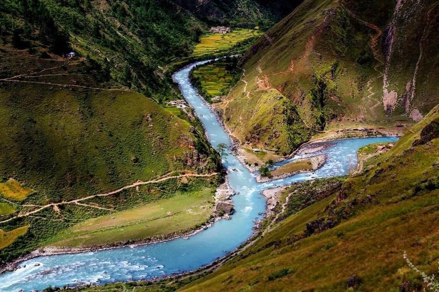
Understanding River Dynamics: Why Some Rivers Remain Single While Others Split
Why in News?
The research conducted by scientists at the University of California, Santa Barbara (UCSB) has shed light on the long-standing question of why certain rivers flow as single channels while others develop into braided systems. This study, which analyzed 84 rivers over a span of 36 years using satellite data, reveals critical insights into river behavior and its implications for flood management and ecological conservation, especially in the face of climate change.
Key Takeaways
- The study indicates that erosion, rather than equilibrium, is the primary factor driving rivers to split into multiple channels.
- Understanding the dynamics of single-thread versus multi-thread rivers is crucial for effective flood prediction and ecosystem management.
Additional Details
- Single-thread rivers: These rivers maintain a balance between bank erosion and sediment deposition, resulting in a stable width.
- Multi-thread rivers: Characterized by an imbalance where erosion outpaces deposition, causing channels to widen and frequently split, as seen in the Brahmaputra River, which erodes laterally at a rapid rate.
- Scientific Methodology: The study utilized Particle Image Velocimetry (PIV) to analyze satellite images, resulting in over 400,000 measurements of erosion and accretion across various climates.
- Ecological Insights: Recent findings suggest that vegetation plays a significant role in river morphology, impacting how bends in rivers migrate and evolve.
In conclusion, the findings from UCSB's research present a transformative understanding of why rivers split and the implications on flood management, river restoration, and ecological conservation. Particularly in India, where major rivers like the Ganga and Brahmaputra face challenges from human interventions, adopting natural solutions could lead to more sustainable water governance amidst climate change.
Deadly Earthquake in Afghanistan
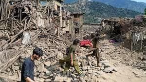
Why in News?
A recent powerful earthquake in Afghanistan resulted in the tragic loss of at least 800 lives and left thousands injured, underscoring the country's severe vulnerability to seismic hazards.
Key Takeaways
- Afghanistan is located in a seismically active region due to its geological setting.
- The ongoing collision of tectonic plates contributes to frequent and severe earthquakes.
- Key earthquake-prone regions include the Hindu Kush, Sulaiman Range, and Main Pamir Thrust Zone.
Additional Details
- Geological Setting: Afghanistan is situated in the Hindu Kush mountains, part of the Alpide Belt, which is the second most seismically active area globally after the Circum-Pacific.
- Tectonic Origin: The region was formed by the closure of the Tethys Ocean, resulting from the collision of the African, Arabian, and Indian Plates with the Eurasian Plate.
- Ongoing Collision: The continuous movement of the Indian Plate into the Eurasian Plate results in the formation of mountain ranges like the Himalayas and Hindu Kush, leading to significant seismic activity.
- Seismic Characteristics: Afghanistan experiences both shallow-focus earthquakes (0–70 km depth) causing major destruction and rare deep-focus quakes (up to 200 km) unique to the Hindu Kush.
- Fault Structures: Major faults exist where the Indian and Eurasian Plates converge, making Afghanistan highly fractured and vulnerable to tremors.
Due to these geographic and tectonic factors, Afghanistan is considered one of the most earthquake-prone countries, facing repeated deadly events since the 1990s.
Consider the following statements:
- 1. In a seismograph, P waves are recorded earlier than S waves.
- 2. In P waves, individual particles vibrate to and fro in the direction of wave propagation, whereas in S waves, particles vibrate up and down at right angles to the direction of wave propagation.
Which of the statements given above is/are correct?
- Options: (a) 1 only (b) 2 only (c) Both 1 and 2 (d) Neither 1 nor 2
Freshwater Aquifers Found Beneath the Atlantic Ocean

Why in News?
The recent discovery of a significant freshwater aquifer beneath the Atlantic shelf presents new opportunities to tackle potential global water shortages.
Key Takeaways
- Location: Offshore northeastern U.S., possibly extending from New Jersey to Maine.
- Expedition 501: Drilled up to 400 m beneath the seabed, retrieving nearly 50,000 liters of water and numerous sediment cores.
- Findings: Freshwater and nearly fresh water identified at both shallower and deeper depths than anticipated, confirming the existence of a large, pressurized aquifer.
- Global Context: Similar offshore aquifers are suspected or have been identified in regions such as South Africa, Hawai‘i, Jakarta, and Canada’s Prince Edward Island.
Possible Origins of the Freshwater
- Glacial Meltwater Hypothesis: Ancient ice sheets during periods of lower sea levels allowed meltwater to permeate into porous sediments.
- Connected Aquifer Hypothesis: Modern terrestrial groundwater may still gradually flow offshore through geological formations.
Significance of the Discovery
- Water Security: Could potentially supply a metropolis the size of New York City for centuries if managed sustainably.
- Climate Change Resilience: Provides alternative options as coastal aquifers are threatened by saltwater intrusion and rising urban demand, exemplified by Cape Town’s “Day Zero” crisis in 2018.
- Scientific Impact: Marks the first systematic drilling of offshore freshwater for mapping and salinity profiling.
This discovery not only enhances our understanding of freshwater resources but also emphasizes the importance of sustainable management in the face of climate challenges.
|
1360 docs|798 tests
|
FAQs on Geography: September 2025 Current Affairs - Current Affairs: Daily, Weekly & Monthly - CLAT
| 1. What is a Blood Moon and how is it related to a lunar eclipse? |  |
| 2. What are the main issues involved in the Cauvery River dispute? | |
| 3. What are Erra Matti Dibbalu and their significance in geography? | |
| 4. How does the South-west Monsoon affect the climate in India? | |
| 5. What are the implications of freshwater aquifers found beneath the Atlantic Ocean? | |


Exam
,Summary
,Weekly & Monthly - CLAT
,Semester Notes
,Viva Questions
,MCQs
,Previous Year Questions with Solutions
,Geography: September 2025 Current Affairs | Current Affairs: Daily
,Weekly & Monthly - CLAT
,Weekly & Monthly - CLAT
,Extra Questions
,mock tests for examination
,Geography: September 2025 Current Affairs | Current Affairs: Daily
,practice quizzes
,Sample Paper
,ppt
,Important questions
,study material
,past year papers
,Objective type Questions
,shortcuts and tricks
,Geography: September 2025 Current Affairs | Current Affairs: Daily
,video lectures
,Free
;


Geography: September 2025 Current Affairs Free PDF Download
Importance of Geography: September 2025 Current Affairs
Geography: September 2025 Current Affairs Notes
Geography: September 2025 Current Affairs CLAT Questions
Study Geography: September 2025 Current Affairs on the App
|
© EduRev
|
Education Revolution
|


|


