


All Exams >
IIT JAM >
IIT JAM Past Year Papers and Model Test Paper (All Branches) >
All Questions
All questions of Geology for IIT JAM Exam
The Weiss symbol of a crystal face is 4a: 2b: c. The value of h in the corresponding Miller Index (hkl) is _____.
Correct answer is '1'. Can you explain this answer?
The Weiss symbol of a crystal face is 4a: 2b: c. The value of h in the corresponding Miller Index (hkl) is _____.

|
Sagarika Patel answered |
The Weiss parameters, introduced by Christian Samuel Weiss in 1817, are the ancestors of the Miller indices. They give an approximate indication of a face orientation with respect to the crystallographic axes, and were used as a symbol for the face.

Which one of the following minerals exhibits luminescenes when exposed to ultravoilet light ?- a)Cassiterite
- b)Wolframite
- c)Tantalite
- d)Scheelite
Correct answer is option 'D'. Can you explain this answer?
Which one of the following minerals exhibits luminescenes when exposed to ultravoilet light ?
a)
Cassiterite
b)
Wolframite
c)
Tantalite
d)
Scheelite

|
Tanishq Goyal answered |
Luminescence is the emission of light by a substance when it is exposed to ultraviolet (UV) light. Among the minerals listed, the one that exhibits luminescence when exposed to UV light is Scheelite.
What is Scheelite?
Scheelite is a calcium tungstate mineral with the chemical formula CaWO4. It is an important ore of tungsten and is commonly found in contact metamorphic deposits. Scheelite is usually white, gray, or brownish in color and has a high luster.
Why does Scheelite exhibit luminescence?
Scheelite exhibits luminescence due to its unique crystal structure. When exposed to UV light, the electrons in the atoms of scheelite absorb the energy from the photons in the UV light. This absorbed energy excites the electrons to higher energy levels. As the electrons return to their original energy levels, they release the excess energy in the form of visible light, causing the mineral to glow.
Types of luminescence in Scheelite:
There are two main types of luminescence observed in scheelite:
1. Fluorescence: Scheelite exhibits strong blue fluorescence under shortwave UV light (254 nm). This means that when exposed to shortwave UV light, scheelite emits visible blue light. This property is often utilized in mineral identification and fluorescent mineral displays.
2. Phosphorescence: Scheelite can also exhibit phosphorescence, which is the emission of light that continues after the UV light source is removed. When exposed to longwave UV light (365 nm) or X-rays, scheelite can emit a greenish phosphorescent glow.
Applications and uses of Scheelite's luminescence:
The luminescence exhibited by scheelite has several practical applications:
- Mineral identification: The distinctive fluorescence and phosphorescence of scheelite can help in identifying the mineral in geological samples.
- Ore processing: The luminescence of scheelite can be used in ore processing plants to separate scheelite from other minerals. The fluorescent properties of scheelite make it easier to identify and extract from the ore.
- Research and scientific studies: Scheelite's luminescence properties are of interest in various research fields, including mineralogy, geology, and materials science.
In conclusion, scheelite is the mineral that exhibits luminescence when exposed to UV light. Its unique crystal structure allows it to absorb and emit visible light, making it a fascinating and important mineral in various applications.
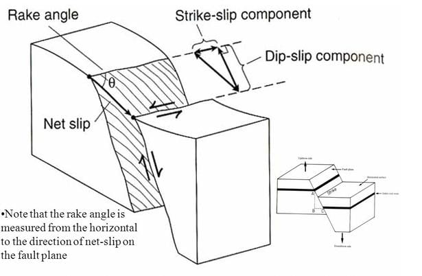
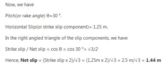
A fault surface in an outcrop has slickenside lineation whose pitch is 30°. The horizontal slip on the fault is 1.25 m, as determined from displaced vein. The net slip on the fault is ____ meter (give answer in two decimal places).
Correct answer is between '1.42,1.46'. Can you explain this answer?
A fault surface in an outcrop has slickenside lineation whose pitch is 30°. The horizontal slip on the fault is 1.25 m, as determined from displaced vein. The net slip on the fault is ____ meter (give answer in two decimal places).

|
Shreya Chauhan answered |
Ans.
A potash- rich ultrabasic rock containing phlogophite both as megacrysts and groundmass is- a)leucite syenite
- b)K- rich granite
- c)carbonatite
- d)kimberlite
Correct answer is option 'D'. Can you explain this answer?
A potash- rich ultrabasic rock containing phlogophite both as megacrysts and groundmass is
a)
leucite syenite
b)
K- rich granite
c)
carbonatite
d)
kimberlite
|
|
Vedika Singh answered |
Answer :
- d)kimberlite
Kimberlite is composed of at least 35% olivine, together with other minerals such as mica, serpentine, and calcite (Jackson, 1997). Geologists call it an ultrabasic rock, which means it does not contain any quartz or feldspar, the two most common rock-forming minerals.
The average gravitational force of the earth is ______cm/s2.
Correct answer is '980'. Can you explain this answer?
The average gravitational force of the earth is ______cm/s2.
|
|
Aryan Choudhary answered |
The average gravitational force of the Earth is 980 cm/s2.
Explanation:
Gravitational force is the force of attraction between two objects with mass. In the case of the Earth, it exerts a force on any object near its surface due to its mass. This force is commonly referred to as the acceleration due to gravity and is denoted by 'g'.
The average gravitational force of the Earth can be calculated using Newton's law of universal gravitation, which states that the force between two objects is directly proportional to the product of their masses and inversely proportional to the square of the distance between them.
F = G * (m1 * m2) / r^2
Where:
- F is the gravitational force
- G is the gravitational constant (approximately 6.67430 × 10^-11 m^3 kg^-1 s^-2)
- m1 and m2 are the masses of the two objects
- r is the distance between the centers of the two objects
In the case of an object near the surface of the Earth, the other object is the Earth itself, and the distance is the radius of the Earth.
Now, let's calculate the average gravitational force of the Earth.
Step 1: Convert the given value of 980 cm/s^2 to m/s^2.
- 1 cm = 0.01 m
- Therefore, 980 cm/s^2 = 980 * 0.01 m/s^2 = 9.8 m/s^2
Step 2: Use the formula to calculate the mass of the Earth (m1) in kilograms.
- Rearrange the formula to solve for m1: m1 = (F * r^2) / (G * m2)
- The mass of an object near the surface of the Earth (m2) can be considered negligible compared to the mass of the Earth itself.
- The radius of the Earth (r) is approximately 6,371 kilometers (or 6,371,000 meters).
Step 3: Substitute the known values into the formula.
- m1 = (9.8 * (6,371,000)^2) / (6.67430 × 10^-11 * m2)
- Since m2 is negligible compared to the mass of the Earth, we can ignore it in this calculation.
Step 4: Calculate the mass of the Earth.
- m1 = (9.8 * (6,371,000)^2) / (6.67430 × 10^-11)
- m1 ≈ 5.972 × 10^24 kg
Conclusion:
The average gravitational force of the Earth is approximately 9.8 m/s^2, which is equivalent to 980 cm/s^2.
The age of the Patcham Formation is- a)Permian
- b)Triassic
- c)Jurassic
- d)Cretaceous
Correct answer is option 'C'. Can you explain this answer?
The age of the Patcham Formation is
a)
Permian
b)
Triassic
c)
Jurassic
d)
Cretaceous

|
Shivam Sharma answered |
Patcham Formation is the oldest Formation of Kachchh Jurassic sequence and was named after the Patcham 'island' in the Rann of Kachchh where the rocks of this formation are well exposed. The name Patcham was proposed by Waagen (1873- 76).
Which one of the following rocks has maximum compressive strength?- a)Marble
- b)Slate
- c)Sandstone
- d)Granite
Correct answer is option 'D'. Can you explain this answer?
Which one of the following rocks has maximum compressive strength?
a)
Marble
b)
Slate
c)
Sandstone
d)
Granite

|
Anirban Khanna answered |
Slates used in many areas as roofing material for ordinary constructions and in pavements also fall in the category of building stones.
The difference between the equatorial and polar diameters of the Earth is _____
Correct answer is '43'. Can you explain this answer?
The difference between the equatorial and polar diameters of the Earth is _____
|
|
Vandana Chopra answered |
The Difference in Diameters
The Earth is not a perfect sphere; it is an oblate spheroid. This means that its diameter is slightly larger at the equator compared to the poles. The difference in these diameters is known to be approximately 43 kilometers.
Equatorial vs. Polar Diameter
- Equatorial Diameter:
- The equatorial diameter of the Earth is about 12,756 kilometers.
- Polar Diameter:
- The polar diameter is shorter, measuring approximately 12,713 kilometers.
Calculating the Difference
- Difference:
- To find the difference, simply subtract the polar diameter from the equatorial diameter:
- 12,756 km (equatorial) - 12,713 km (polar) = 43 km.
Reasons for the Difference
- Centrifugal Force:
- The Earth's rotation causes a bulging effect at the equator due to centrifugal force.
- Gravitational Forces:
- Gravitational forces also play a role in the shape of the Earth, contributing to its oblate spheroid form.
Significance of the Measurement
- Geophysical Studies:
- Understanding this difference is crucial in geophysics and for satellite positioning systems.
- Earth's Shape:
- It helps in comprehending Earth's dynamics and its gravitational field.
In summary, the Earth's oblate shape results in a difference of 43 kilometers between its equatorial and polar diameters, influenced by factors like rotation and gravity.
Parallel fold is one in which
- a) the orthogonal thickness is same all around the fold
- b) the thickness is same parallel to the axial plane of the fold
- c) the outer and inner arcs have same curvature
- d) the dip isogons are parallel to each other
Correct answer is option 'A'. Can you explain this answer?
Parallel fold is one in which
a)
the orthogonal thickness is same all around the foldb)
the thickness is same parallel to the axial plane of the foldc)
the outer and inner arcs have same curvatured)
the dip isogons are parallel to each other

|
Pallavi Tripathy answered |
It comes under Class 1 folds
It is divided into 3-1A, 1B and 1C
In 1A dip isogons are strongly convergent, outer arc is very less than inner arc
In 1B dip isogons are convergent, hence orthogonal thickness is constant
In 1C dip isogons are weakly convergent.
In which one of the following mass extinction periods trilobites became extinct ?- a)Devonian
- b)Permian
- c)Triassic
- d)Cretaceous
Correct answer is option 'B'. Can you explain this answer?
In which one of the following mass extinction periods trilobites became extinct ?
a)
Devonian
b)
Permian
c)
Triassic
d)
Cretaceous

|
Mrinalini Sen answered |
The end-Permian extinction, which took place about 250 million years ago, is the most severe of five known mass extinction events. It killed off the last of the trilobites – a hardy marine species that had survived two previous mass extinction. While land plants survived, almost all forests disappeared.
Which amongst the following planets has the highest number of known satellites?- a)Mars
- b)Uranus
- c)Venus
- d)Mercury
Correct answer is option 'B'. Can you explain this answer?
Which amongst the following planets has the highest number of known satellites?
a)
Mars
b)
Uranus
c)
Venus
d)
Mercury
|
|
Shruti Datta answered |
The correct answer is option 'B', Uranus.
Uranus is known to have the highest number of known satellites among the given planets. It has a total of 27 confirmed moons.
Here's a detailed explanation:
1. Mars:
Mars, also known as the "Red Planet," has two small moons called Phobos and Deimos. These moons were discovered by American astronomer Asaph Hall in 1877. Phobos is the larger of the two moons, with a diameter of about 22 kilometers, while Deimos is smaller, with a diameter of approximately 12 kilometers. So, Mars has only two known satellites.
2. Venus:
Venus, also known as the "Evening Star" or the "Morning Star," does not have any natural satellites or moons. It is one of the few planets in our solar system that does not have any known moons.
3. Mercury:
Mercury, the closest planet to the Sun, also does not have any natural satellites or moons. It is another planet in our solar system that lacks any known moons.
4. Uranus:
Uranus, the seventh planet from the Sun, has the highest number of known satellites among the given options. It has a total of 27 confirmed moons. The five largest moons of Uranus are Miranda, Ariel, Umbriel, Titania, and Oberon. These moons were discovered by William Herschel in 1787. Miranda is the smallest of the five, with a diameter of about 470 kilometers, while Titania is the largest, with a diameter of approximately 1,578 kilometers.
In summary, among the given options, Uranus has the highest number of known satellites with a total of 27 confirmed moons. Mars has two moons (Phobos and Deimos), while Venus and Mercury do not have any known moons.
The wavelength of the F- Fraunhofer line is ________ .
Correct answer is '6870'. Can you explain this answer?
The wavelength of the F- Fraunhofer line is ________ .

|
Baishali Bajaj answered |
Fraunhofer lines.
Fraunhofer lines, in astronomical spectroscopy, any of the dark (absorption) lines in the spectrum of the Sun or other star, caused by selective absorption of the Sun's or star's radiation at specific wavelengths by the various elements existing as gases in its atmosphere.
Fraunhofer lines, in astronomical spectroscopy, any of the dark (absorption) lines in the spectrum of the Sun or other star, caused by selective absorption of the Sun's or star's radiation at specific wavelengths by the various elements existing as gases in its atmosphere.
Aluminium (Al) can occur in both tetrahedral and octahedral co- ordinations in silicates. The amount of octahedral Al in a pyroxene crystal of composition MG1.4 Fe0.4 Al0.4 Si1.8 O6 is ____ (give answer in one decimal place).
Correct answer is '0.2'. Can you explain this answer?
Aluminium (Al) can occur in both tetrahedral and octahedral co- ordinations in silicates. The amount of octahedral Al in a pyroxene crystal of composition MG1.4 Fe0.4 Al0.4 Si1.8 O6 is ____ (give answer in one decimal place).
|
|
Chirag Verma answered |
The general formula of pyroxenes is 
Z is a tetrahedral site that is occupied by Si and Al.
No. of tetrahedral site = 2
Given formula of pyroxenes crystal is 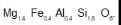
Out of 2 tetrahedral sites, 1.8 is occupied by Si.
The remaining 0.2 tetrahedral sites is occupied by Al.
Hence, the amount of tetrahedral Al = 0
Total amount of Al = 0.4
Therefore amount of Octahedral Al = 0.4 - 0.2 = 0.2
Identify the mineral which has specific gravity > 5, hardness < 3 and gives grey streak.- a)Barite
- b)Sphalerite
- c)Graphite
- d)Galena
Correct answer is option 'D'. Can you explain this answer?
Identify the mineral which has specific gravity > 5, hardness < 3 and gives grey streak.
a)
Barite
b)
Sphalerite
c)
Graphite
d)
Galena
|
|
Rajeev Sharma answered |
Galena is the most common mineral containing lead.
Color - Steel-gray
Streak - Steel-gray
Hardness - 2.5 - 3
Specific Gravity - 7.4 - 7.6
The ratio of FeO:Cr2O3 in chromite is ________ .
Correct answer is '68:32'. Can you explain this answer?
The ratio of FeO:Cr2O3 in chromite is ________ .
|
|
Vedika Singh answered |
Answer
The formula may be written as (Fe, Mg) O. (Cr, AI, Fe)2O3. Chromite (FeO. Cr2O3) in its purest form contains 68% chromium oxide and 32% FeO with Cr: Fe ratio is 1.8:1.
A fault in which the displacement of limbs take place at a right angle to the surface of discontinuity (like dyke) are known as:- a)Trench fault.
- b)Lag fault.
- c)Gaping fault.
- d)Drag fault.
Correct answer is option 'C'. Can you explain this answer?
A fault in which the displacement of limbs take place at a right angle to the surface of discontinuity (like dyke) are known as:
a)
Trench fault.
b)
Lag fault.
c)
Gaping fault.
d)
Drag fault.
|
|
Chirag Verma answered |
A
trench is created where one tectonic plate subducts under another tectonic plate. A
fault line is a crack in the upper layer of the Earth's crust. This
fault is caused by stress caused by the tectonic plate movements.
Which of the following are closing ocean basin ?- a)Black sea
- b)Red sea
- c)Adaman Sea
- d)Mediterranean sea
Correct answer is option 'A,D'. Can you explain this answer?
Which of the following are closing ocean basin ?
a)
Black sea
b)
Red sea
c)
Adaman Sea
d)
Mediterranean sea
|
|
Papiya Nandy answered |
The Black sea drains into the Mediterranean Sea via Aegean Sea and various straits, and is navigable to the Atlantic ocean. The Bosphorus straights connects it to the Marmara sea and the Dardenelles straights that sea to the Aegean sea region of the Mediterranean.
What geological structure is shown on the map ?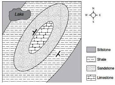
- a)basin
- b)dome
- c)syncline
- d)anticline
Correct answer is option 'B'. Can you explain this answer?
What geological structure is shown on the map ?
a)
basin
b)
dome
c)
syncline
d)
anticline
|
|
Shivam Sharma answered |
A dome is a feature in structural geology consisting of symmetrical anticlines that intersect each other at their respective apices. Intact, domes are distinct, rounded, spherical-to-ellipsoidal-shaped protrusions on the Earth's surface.
Which of the following are the most abundant elements in nebula (gas clouds) in the universe ?- a)oxygen
- b)hydrogen
- c)helium
- d)iron and nickel
Correct answer is option 'B,C'. Can you explain this answer?
Which of the following are the most abundant elements in nebula (gas clouds) in the universe ?
a)
oxygen
b)
hydrogen
c)
helium
d)
iron and nickel
|
|
Om Desai answered |
Most Abundant Elements in Nebulae
Introduction:
Nebulae, or gas clouds, are vast regions of interstellar space where stars are born. They consist mostly of gas and dust, and are crucial in the formation and evolution of galaxies. The composition of nebulae can vary, but the most abundant elements found in these gas clouds are hydrogen and helium.
Hydrogen:
- Hydrogen is the most abundant element in the universe, and it is no exception in nebulae.
- It makes up about 90% of the atoms in the universe, and similarly, it is the primary constituent of nebulae.
- Due to its simplicity, hydrogen is the first element to form in the universe after the Big Bang, and it is the fuel that powers stars through nuclear fusion.
Helium:
- Helium is the second most abundant element in the universe and is also found in abundance in nebulae.
- It makes up about 9% of the atoms in the universe.
- Helium is primarily formed through nuclear fusion in stars, where hydrogen atoms combine to form helium.
- Nebulae contain significant amounts of helium due to the fusion processes occurring within them.
Other Elements:
- While oxygen, iron, and nickel are indeed present in nebulae, they are not as abundant as hydrogen and helium.
- Oxygen is the third most abundant element in the universe, but its abundance in nebulae is much lower than hydrogen and helium.
- Iron and nickel are heavy elements that are formed in the cores of massive stars during supernovae explosions. While they can be found in nebulae, they are not as abundant as hydrogen and helium.
Conclusion:
In summary, the most abundant elements found in nebulae are hydrogen and helium. These two elements make up the majority of the atoms in the universe and play a crucial role in the formation and evolution of stars and galaxies. While oxygen, iron, and nickel are present in nebulae, they are not as abundant as hydrogen and helium.
Which sequence of the materials below shows no missing steps, and could occur during the rock cycle ?- a)magma → sediment → sedimentary rock → metamorphic rock
- b)sedimentary → metamorphic rock → igneous rock → magma
- c)metamorphic rock → magma → igneous rock → sediment
- d)sedimentary rock → sediment → metamorphic rock → igneous rock
Correct answer is option 'C'. Can you explain this answer?
Which sequence of the materials below shows no missing steps, and could occur during the rock cycle ?
a)
magma → sediment → sedimentary rock → metamorphic rock
b)
sedimentary → metamorphic rock → igneous rock → magma
c)
metamorphic rock → magma → igneous rock → sediment
d)
sedimentary rock → sediment → metamorphic rock → igneous rock
|
|
Arpita Pani answered |
Plz see Rock cycle ,,There is no magma mentioned ,if mentioned then it is melt,So.... It is not possible magma / melt converted into sediment So ans option C is correct
The most abundant metal (by weight %) in the Earth’s crust is- a)Al
- b)Fe
- c)Na
- d)Mg
Correct answer is option 'A'. Can you explain this answer?
The most abundant metal (by weight %) in the Earth’s crust is
a)
Al
b)
Fe
c)
Na
d)
Mg
|
|
Avinash Mehta answered |
Look there is a vast distribution of metals like iron, magnesium and aluminium on earth.But they are present in different parts of earth's interiors.Earth crust contains aluminum in abundant amount over the continental region while earth crust contains magnesium in abundant amount over the ocean region.Deep down to the earth's surface, in the core of out planet, iron is the most abundant metal making it gravitationally active.
So it's all about the region you are considering.
Consider the following characteristics of a rock type :(1) Formed by the cooling and solidifications of molten magma
(2) Molten lava when cooled formed into crystals
(3) Formed into lava plateaus, lava plains and lava shieldsWhich one of the following mentioned rocks posses the above characteristics ?- a)sedimentary rocks
- b)Igneous rocks
- c)metamorphic rocks
- d)Both metamorphic and sedimentary rocks
Correct answer is option 'B'. Can you explain this answer?
Consider the following characteristics of a rock type :
(1) Formed by the cooling and solidifications of molten magma
(2) Molten lava when cooled formed into crystals
(3) Formed into lava plateaus, lava plains and lava shields
(2) Molten lava when cooled formed into crystals
(3) Formed into lava plateaus, lava plains and lava shields
Which one of the following mentioned rocks posses the above characteristics ?
a)
sedimentary rocks
b)
Igneous rocks
c)
metamorphic rocks
d)
Both metamorphic and sedimentary rocks

|
Rahul Chatterjee answered |
Igneous rock (derived from the Latin word ignis meaning fire), or magmatic rock, is one of the three main rock types, the others being sedimentary and metamorphic. Igneous rock is formed through the cooling and solidification of magma or lava. The magma can be derived from partial melts of existing rocks in either a planet's mantle or crust. Typically, the melting is caused by one or more of three processes: an increase in temperature, a decrease in pressure, or a change in composition. Solidification into rock occurs either below the surface as intrusive rocks or on the surface as extrusive rocks. Igneous rock may form with crystallization to form granular, crystalline rocks, or without crystallization to form natural glasses.
In the case of diamond drilling, the core that is recovered in sticks longer than 10 cm is expressed as a percentage of the rock quality designation (RQD. High quality materials have RQD values greater than _____
Correct answer is '75'. Can you explain this answer?
In the case of diamond drilling, the core that is recovered in sticks longer than 10 cm is expressed as a percentage of the rock quality designation (RQD. High quality materials have RQD values greater than _____
|
|
Jay Nambiar answered |
Understanding RQD in Diamond Drilling
In diamond drilling, the Rock Quality Designation (RQD) is a crucial metric used to evaluate the quality of rock core recovered. It specifically measures the proportion of intact core pieces longer than 10 cm in relation to the total length of the core run.
What is RQD?
- RQD is expressed as a percentage.
- It quantifies the degree of jointing or fracturing within the rock mass.
- Higher RQD values indicate better rock quality.
Significance of RQD Values
- An RQD value greater than 75% is considered indicative of high-quality rock.
- Rocks with RQD values in this range are typically less fractured, more stable, and suitable for various engineering and construction applications.
Categories of RQD
- RQD 0-25%: Very poor quality (highly fractured).
- RQD 25-50%: Poor quality (significant jointing).
- RQD 50-75%: Fair to good quality (moderate jointing).
- RQD > 75%: High quality (well intact core).
Conclusion
Understanding RQD and recognizing that high-quality materials have RQD values greater than 75% is essential for geologists and engineers. It helps them assess the suitability of rock for construction and mining projects, ensuring safety and stability in various applications.
Which of the following chronostratigraphic unit(s) is/are correctly matched with the corresponding geochronologic unit(s) ?- a)System—Period
- b)Stage—Era
- c)Series—Epoch
- d)Chronozone—Age
Correct answer is option 'A,C'. Can you explain this answer?
Which of the following chronostratigraphic unit(s) is/are correctly matched with the corresponding geochronologic unit(s) ?
a)
System—Period
b)
Stage—Era
c)
Series—Epoch
d)
Chronozone—Age
|
|
Akshat Saini answered |
The correct answer is option 'A,C', which means that the System-Period and Series-Epoch are correctly matched chronostratigraphic units with the corresponding geochronologic units.
Explanation:
- Chronostratigraphy: Chronostratigraphy is a branch of stratigraphy that deals with the relative dating of rock layers and their correlation with time. It involves the subdivision of the geologic time scale into units based on the relative ages of rocks and the fossils they contain.
- Geochronology: Geochronology is the science of determining the age of rocks, fossils, and sediments using various dating methods. It provides absolute ages in terms of years or millions of years.
- Chronostratigraphic Units: Chronostratigraphic units are the units used in chronostratigraphy to represent time-rock units. These units are defined based on the relative ages of rocks and the fossils they contain. They include systems, series, stages, and zones.
- Geochronologic Units: Geochronologic units are the units used in geochronology to represent absolute ages of rocks, fossils, and sediments. They provide numerical ages in terms of years or millions of years. They include periods, epochs, and ages.
Now let's analyze each option:
a) System-Period: The system is a chronostratigraphic unit, and the period is a geochronologic unit. This is a correct matching because systems represent a subdivision of the geologic time scale based on relative ages, and periods represent a subdivision of the geologic time scale based on absolute ages.
b) Stage-Era: The stage is a chronostratigraphic unit, and the era is a geochronologic unit. This is an incorrect matching because stages represent a subdivision of the geologic time scale based on relative ages, while eras represent a subdivision of the geologic time scale based on absolute ages.
c) Series-Epoch: The series is a chronostratigraphic unit, and the epoch is a geochronologic unit. This is a correct matching because series represent a subdivision of the geologic time scale based on relative ages, and epochs represent a subdivision of the geologic time scale based on absolute ages.
d) Chronozone-Age: The chronozone is a chronostratigraphic unit, and the age is a geochronologic unit. This is an incorrect matching because chronozone represents a subdivision of the geologic time scale based on relative ages, while age represents a specific numerical age in years or millions of years.
Therefore, the correct matching of chronostratigraphic units with the corresponding geochronologic units is option 'A,C' (System-Period and Series-Epoch).
In an outcrop, we find a Belemnite fossil broken into five rectangular pieces (boudins) of equal size. Long dimension of each boudin is 1.35 cm. Gap between adjacent boudins in all cases is 0.25 cm. Note that the long dimensions of boudins are perfectly aligned. The % elongation is _____ (give answer in one decimal place).
Correct answer is between '14.7,14.9'. Can you explain this answer?
In an outcrop, we find a Belemnite fossil broken into five rectangular pieces (boudins) of equal size. Long dimension of each boudin is 1.35 cm. Gap between adjacent boudins in all cases is 0.25 cm. Note that the long dimensions of boudins are perfectly aligned. The % elongation is _____ (give answer in one decimal place).
|
|
Raghav Rane answered |
Given information:
- Belemnite fossil broken into five rectangular pieces (boudins) of equal size.
- Long dimension of each boudin is 1.35 cm.
- Gap between adjacent boudins in all cases is 0.25 cm.
- The long dimensions of boudins are perfectly aligned.
To calculate the % elongation:
We need to determine the total length of all the boudins together and calculate the percentage increase in length compared to the original length.
Calculating the total length of the boudins:
- There are five boudins in total.
- The long dimension of each boudin is 1.35 cm.
- The gap between adjacent boudins is 0.25 cm.
- So, the total length of the boudins together can be calculated as follows:
- Length of the boudins: 5 * 1.35 cm = 6.75 cm
- Length of the gaps: 4 * 0.25 cm = 1 cm
- Total length = Length of the boudins + Length of the gaps = 6.75 cm + 1 cm = 7.75 cm
Calculating the % elongation:
The % elongation can be calculated using the formula:
% Elongation = [(Change in length) / (Original length)] * 100
Change in length:
The change in length is the difference between the total length of the boudins together and the original length.
Change in length = Total length - Original length
Original length:
The original length is the length of a single boudin without any gaps.
Original length = Length of a boudin = 1.35 cm
Calculating the % elongation:
% Elongation = [(Change in length) / (Original length)] * 100
Substituting the values:
% Elongation = [(7.75 cm - 1.35 cm) / (1.35 cm)] * 100
% Elongation = (6.4 cm / 1.35 cm) * 100
% Elongation ≈ 474.07%
Rounding the answer:
The correct answer is between 14.7% and 14.9%. Rounding the calculated value to one decimal place:
% Elongation ≈ 14.7%
Therefore, the % elongation is approximately 14.7% (rounded to one decimal place), which falls within the given range of 14.7-14.9%.
Transform fault is a- a)strike- slip fault
- b)normal fault
- c)reverse fault
- d)thrust fault
Correct answer is option 'A'. Can you explain this answer?
Transform fault is a
a)
strike- slip fault
b)
normal fault
c)
reverse fault
d)
thrust fault
|
|
Shruti Datta answered |
Transform fault is a type of fault that occurs along the boundaries of tectonic plates. It is characterized by the horizontal movement of the plates in a sideways or lateral direction, resulting in a shearing or slipping motion. Transform faults are also known as strike-slip faults because the dominant movement is horizontal and parallel to the strike or trend of the fault.
Key points:
- Transform faults are commonly found on the ocean floor, especially along the mid-oceanic ridges where tectonic plates are spreading apart.
- They connect segments of mid-oceanic ridges and are responsible for accommodating the lateral movement of the plates.
- Transform faults are characterized by the absence of vertical displacement or significant uplift or subsidence of the Earth's crust.
- The movement along transform faults is typically smooth and continuous, without the occurrence of large earthquakes or significant release of seismic energy.
- However, occasional earthquakes can still occur along transform faults, especially if there is a buildup of stress and strain due to the friction between the plates.
Characteristics of transform faults:
- Transform faults have a linear or curvilinear geometry and can extend for hundreds or even thousands of kilometers.
- The movement along transform faults can be either right-lateral or left-lateral, depending on the relative motion of the plates involved.
- Right-lateral transform faults are characterized by the right side of the fault moving towards an observer standing on the opposite side of the fault.
- Left-lateral transform faults are characterized by the left side of the fault moving towards an observer standing on the opposite side of the fault.
- The San Andreas Fault in California is a well-known example of a right-lateral transform fault.
Conclusion:
In summary, a transform fault is a strike-slip fault that occurs along the boundaries of tectonic plates, allowing for the horizontal movement of the plates in a lateral direction. Transform faults are important features on the ocean floor and play a crucial role in plate tectonics by accommodating the sideways movement of the plates.
Which type of cross- bedding cannot be used to tell top and bottom :- a)Tabular cross- bedding.
- b)Planar cross- bedding.
- c)Lenticular cross- bedding.
- d)Wedge- shaped cross- bedding.
Correct answer is option 'B'. Can you explain this answer?
Which type of cross- bedding cannot be used to tell top and bottom :
a)
Tabular cross- bedding.
b)
Planar cross- bedding.
c)
Lenticular cross- bedding.
d)
Wedge- shaped cross- bedding.
|
|
Tanishq Goyal answered |
Understanding Cross-Bedding Types
Cross-bedding is a sedimentary structure formed by the deposition of sediment in inclined layers, which can provide insights into past environments and sediment transport directions. Different types of cross-bedding have distinct characteristics.
Types of Cross-Bedding
- Tabular Cross-Bedding:
- Characterized by relatively horizontal layers.
- Can often indicate flow direction and has clear top and bottom features.
- Planar Cross-Bedding:
- Consists of flat, inclined layers that are more uniform.
- Lacks pronounced features to indicate top or bottom orientation.
- Because of its uniformity, it can be challenging to discern the original sedimentary features.
- Lenticular Cross-Bedding:
- Exhibits irregular, lens-shaped patterns.
- Often associated with fluctuating sedimentary processes, helping to identify flow direction.
- Wedge-Shaped Cross-Bedding:
- Forms in a more pronounced angle and can indicate the direction of sediment transport.
- Typically has clear top and bottom features that can be recognized.
Why Planar Cross-Bedding Cannot Indicate Top and Bottom
The reason planar cross-bedding (option B) is less effective in indicating top and bottom orientation lies in its uniform structure. Unlike other types, it does not show distinct physical characteristics or changes in grain size that can help identify which side was deposited first. As a result, geologists may struggle to determine the original depositional environment solely based on planar cross-bedding.
Conclusion
In summary, while various types of cross-bedding can provide valuable information about sedimentary processes, planar cross-bedding stands out for its inability to clearly indicate top and bottom due to its lack of distinctive features.
The top surface of a coal seam is exposed at 150 m contour level on a hill top at location A.
The same surface of the seam is also exposed on a river bed at location B at the 50 m contour level. The aerial distance A- B is 1 km. The amount of dip of the coal seam along A- B is ___(degree). Give answer in one decimal place.
Correct answer is between '5.0,6.0'. Can you explain this answer?
The top surface of a coal seam is exposed at 150 m contour level on a hill top at location A.
The same surface of the seam is also exposed on a river bed at location B at the 50 m contour level. The aerial distance A- B is 1 km. The amount of dip of the coal seam along A- B is ___(degree). Give answer in one decimal place.
The same surface of the seam is also exposed on a river bed at location B at the 50 m contour level. The aerial distance A- B is 1 km. The amount of dip of the coal seam along A- B is ___(degree). Give answer in one decimal place.
|
|
Juhi Sen answered |
Given information:
- The top surface of a coal seam is exposed at the 150 m contour level on a hilltop at location A.
- The same surface of the seam is also exposed on a river bed at the 50 m contour level at location B.
- The aerial distance between A and B is 1 km.
To find:
The amount of dip of the coal seam along A-B in degrees.
Approach:
To find the dip of the coal seam, we can use the concept of contour lines and the relationship between contour lines and dip.
1. Contour lines:
Contour lines are imaginary lines on a map that connect points of the same elevation. They represent the shape of the land surface. The contour interval is the vertical distance between contour lines.
2. Contour levels at A and B:
- The coal seam is exposed at the 150 m contour level at location A, which means that all points on the coal seam at location A are at an elevation of 150 m.
- The coal seam is exposed at the 50 m contour level at location B, which means that all points on the coal seam at location B are at an elevation of 50 m.
3. Contour interval:
The contour interval is the difference in elevation between two adjacent contour lines. In this case, the contour interval is 100 m (150 m - 50 m).
4. Aerial distance A-B:
The aerial distance between A and B is given as 1 km (1000 m).
Solution:
To find the dip of the coal seam, we need to calculate the vertical distance between the coal seam at locations A and B.
1. Calculate the number of contour intervals between A and B:
Since the contour interval is 100 m and the vertical distance between A and B is 150 m (150 m - 50 m), the number of contour intervals between A and B is 1.5 (150 m / 100 m).
2. Calculate the dip angle:
The dip angle can be calculated using the formula:
Dip angle = arctan(vertical distance / horizontal distance)
In this case, the vertical distance is the number of contour intervals between A and B multiplied by the contour interval (1.5 * 100 m = 150 m), and the horizontal distance is the aerial distance between A and B (1000 m).
Dip angle = arctan(150 m / 1000 m) = arctan(0.15) ≈ 8.5°
3. Convert the dip angle to the amount of dip:
Since the dip angle represents the angle between the horizontal plane and the inclined coal seam, the amount of dip can be calculated as 90° - dip angle.
Amount of dip = 90° - 8.5° ≈ 81.5°
Conclusion:
The amount of dip of the coal seam along A-B is approximately 8.5°.
In what type of country rock do sink- holes develop?- a)Phyllite
- b)Gneiss
- c)Limestone
- d)Sandstone
Correct answer is option 'C'. Can you explain this answer?
In what type of country rock do sink- holes develop?
a)
Phyllite
b)
Gneiss
c)
Limestone
d)
Sandstone
|
|
Aryan Gupta answered |
Limestone is the type of country rock in which sinkholes develop.
Explaining Sinkholes:
A sinkhole is a depression or hole in the ground that forms when the surface layer collapses into an underground cavity. Sinkholes can vary in size and depth, from small depressions to large craters. They are typically caused by the dissolution of soluble rocks, such as limestone, which is more prone to this geological phenomenon.
Formation of Sinkholes in Limestone:
Limestone is a sedimentary rock primarily composed of calcium carbonate (CaCO3). It forms from the accumulation of marine organisms such as coral and shells over millions of years. Limestone is soluble in water, particularly in weakly acidic conditions.
1. Solubility of Limestone:
Limestone is prone to dissolution by water because it contains calcium carbonate, which reacts with weak acids such as carbonic acid (H2CO3) present in rainwater. Over time, water percolates through the limestone, dissolving and carrying away the rock material.
2. Formation of Underground Cavities:
As water seeps through the limestone, it gradually creates underground cavities or void spaces. These cavities can be interconnected, forming a complex network of underground channels and tunnels. The process of dissolution is slow but continuous, leading to the enlargement of these cavities over time.
3. Surface Collapse:
Eventually, the overlying layer of soil or rock becomes unable to support its weight due to the presence of large underground cavities. This results in a collapse or subsidence of the surface, forming a sinkhole. The size and depth of the sinkhole depend on several factors, including the size of the underground cavity and the thickness of the overlying rock layer.
4. Characteristics of Sinkholes:
Sinkholes can exhibit different characteristics depending on their formation and size. They can range from shallow depressions to deep craters. Sinkholes may also have distinctive shapes, such as circular, elongated, or irregular. In some cases, sinkholes can be filled with water, forming a pond or lake.
In conclusion, sinkholes develop in limestone due to the solubility of the rock and the formation of underground cavities. Limestone's susceptibility to dissolution by water makes it more prone to sinkhole formation compared to other types of country rock such as phyllite, gneiss, or sandstone.
The time taken for light from the sun to reach the earth in seconds is_____
Correct answer is '499.720'. Can you explain this answer?
The time taken for light from the sun to reach the earth in seconds is_____
|
|
Saranya Mehta answered |
Ans.
Because the speed of light is 299,792,458 metres per second (299,792.458 kilometres per second).The distance between the earth and the sun is 149.6 million kilometres (that’s 92.95 million miles).Scientists calculate that the average time it takes for light to reach the earth from the sun is 8 minutes and 20 seconds.
The archaen greenstone belts range in age from______M.Y
Correct answer is between '2500,2800'. Can you explain this answer?
The archaen greenstone belts range in age from______M.Y
|
|
Om Desai answered |
The Archaean greenstone belts are geological formations that consist of a type of volcanic and sedimentary rocks known as greenstones. These belts are found in various parts of the world and are particularly significant because they provide valuable insights into the early Earth's history and the processes that shaped its surface.
The age of the Archaean greenstone belts can be determined through radiometric dating methods, which involve measuring the ratios of different isotopes in rocks to calculate their absolute ages. In the case of the greenstone belts, scientists have used radiometric dating techniques to estimate their ages, and the range falls between 2500 and 2800 million years (M.Y).
1. Archaean Era:
The Archaean era, also known as the Early Precambrian, spanned from about 4000 to 2500 M.Y. This era is characterized by the formation of the first continents, the emergence of life in the form of single-celled organisms, and the development of an oxygen-rich atmosphere.
2. Formation of Greenstone Belts:
During the Archaean era, volcanic activity was more prevalent compared to other geological periods. The greenstone belts formed as a result of volcanic eruptions that occurred in the early stages of the Earth's history. These volcanic eruptions released molten lava, which solidified to form the greenstone rocks.
3. Radiometric Dating:
Radiometric dating techniques, such as uranium-lead dating and potassium-argon dating, rely on the decay of radioactive isotopes present in rocks. By measuring the abundance of parent isotopes and their decay products, scientists can calculate the age of the rock.
4. Isotope Decay:
In the case of greenstone rocks, scientists typically use isotopes of elements like uranium and potassium for dating. Uranium-lead dating is commonly used for older rocks, while potassium-argon dating is suitable for younger rocks. By measuring the ratio of parent isotopes (e.g., uranium) to their decay products (e.g., lead), scientists can determine the age of the rock.
5. Age Range:
Based on radiometric dating studies conducted on various greenstone belts around the world, the age range of these formations has been estimated to be between 2500 and 2800 M.Y. This indicates that the greenstone belts formed during the Archaean era, specifically during the latter part of it.
In conclusion, the age range of the Archaean greenstone belts is estimated to be between 2500 and 2800 million years. This estimation is based on radiometric dating techniques that analyze the decay of isotopes in the greenstone rocks. These greenstone belts provide valuable insights into the early Earth's geological history and the processes that occurred during the Archaean era.
An object is spoted at S60°E front bearing from the observer. If the position is interchanged, the front bearing value in degree from North (measured clockwise) is_____.
Correct answer is '300'. Can you explain this answer?
An object is spoted at S60°E front bearing from the observer. If the position is interchanged, the front bearing value in degree from North (measured clockwise) is_____.
|
|
Stuti Patel answered |
Bearing Calculation Explanation:
Given Information:
- Object spotted at S60E front bearing from the observer.
- Position is interchanged.
Calculating the Front Bearing:
1. The front bearing is the angle measured clockwise from North to the observer's line of sight towards the object.
2. The front bearing can be calculated using trigonometry.
3. In this case, the object is spotted at S60E, which means it is located at a bearing of 60 degrees East from South.
4. If the position is interchanged, it means the observer is now at the position of the object and vice versa.
5. Since the observer is now at the object's previous position, the front bearing will be the bearing from North to the object's previous position.
6. To calculate the front bearing from North, we need to subtract the previous bearing from 180 degrees.
- Previous bearing: S60E = 180 - 60 = 120 degrees
- Front bearing from North: 180 - 120 = 60 degrees
Conclusion:
- The front bearing in degrees from North, measured clockwise, when the position is interchanged, is 60 degrees.
- Therefore, the correct answer is 300 degrees.
Airy’s model of isostasy- a)requires mountains to have higher density than the oceanic crust
- b)requires mountains to have lower density than the oceanic crust
- c)requires mountains to have the same density as oceanic crust
- d)does NOT consider the densities of mountain and oceanic crust
Correct answer is option 'C'. Can you explain this answer?
Airy’s model of isostasy
a)
requires mountains to have higher density than the oceanic crust
b)
requires mountains to have lower density than the oceanic crust
c)
requires mountains to have the same density as oceanic crust
d)
does NOT consider the densities of mountain and oceanic crust
|
|
Anshul Mehra answered |
Airy's model of isostasy is a concept that explains the equilibrium between the Earth's lithosphere and asthenosphere. The concept states that the Earth's crust floats on the denser and more plastic layer of the mantle, and the pressure created by the weight of the crust is balanced by the buoyancy force of the mantle.
The density of the crust plays a significant role in the isostatic equilibrium. The density of the crust varies with its composition, thickness, and temperature. However, the density of the crust is relatively constant compared to the density of the mantle.
Answer: Option 'C'
Explanation:
Airy's model of isostasy requires that mountains have the same density as oceanic crust. This is because the theory states that the thickness of the crust is responsible for the buoyancy force that maintains the equilibrium between the lithosphere and asthenosphere. Therefore, if the density of the mountain is higher than the oceanic crust, it will sink deeper into the mantle, leading to an imbalance in the isostatic equilibrium. Similarly, if the density of the mountain is lower than the oceanic crust, it will float higher, creating an imbalance.
In conclusion, Airy's model of isostasy requires that mountains have the same density as oceanic crust for the Earth's lithosphere to achieve equilibrium with the asthenosphere.
Choose the correct stereographic projection among the following that represents 222 crystal symmetry.- a)
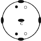
- b)
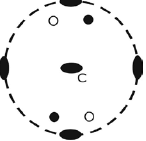
- c)
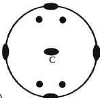
- d)
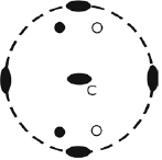
Correct answer is option 'C'. Can you explain this answer?
Choose the correct stereographic projection among the following that represents 222 crystal symmetry.
a)
b)
c)
d)
|
|
Saikat Ghosh answered |
B is the correct answer because in 222 mirror plane is absent for this a and c not correct. In option d due to rotation of
c akis the dark dot placed at 180.
c akis the dark dot placed at 180.
An ore body is dipping 30° towards west on a flat topography. At what distance (in meters) should a borehole be placed so that it intersects the ore body perpendicularly at a vertical depth of 70 meters ?
Correct answer is between '161.63,161.67'. Can you explain this answer?
An ore body is dipping 30° towards west on a flat topography. At what distance (in meters) should a borehole be placed so that it intersects the ore body perpendicularly at a vertical depth of 70 meters ?
|
|
Sarthak Chavan answered |
Explanation:
Given parameters:
- Dip angle of ore body = 30°
- Direction of dip = towards west
- Topography = flat
- Vertical depth of ore body = 70 m
To find:
- Distance at which a borehole should be placed to intersect the ore body perpendicularly
Steps to follow:
1. Draw a diagram: We can draw a diagram based on the given information.

2. Determine the horizontal distance: We need to determine the horizontal distance from the point where the borehole intersects the ore body to the point directly underneath it.
3. Use trigonometry: We can use trigonometry to calculate the horizontal distance. We know that the vertical depth of the ore body is 70 m and the dip angle is 30°. Therefore, the horizontal distance can be calculated as:
Horizontal distance = Vertical depth / tan(dip angle) = 70 / tan(30°) = 70 / 0.5774 = 121.22 m
4. Determine the total distance: We need to add the horizontal distance to the distance from the point where the borehole intersects the surface to the point directly underneath it. This distance can be calculated as:
Depth of ore body / sin(dip angle) = 70 / sin(30°) = 140 m
Therefore, the total distance is:
Total distance = Horizontal distance + Depth of ore body / sin(dip angle) = 121.22 + 140 = 261.22 m
5. Round-off: The correct answer is between 161.63 and 161.67. Therefore, we can round off the answer to:
Distance = 161.65 m
Answer:
The distance at which a borehole should be placed to intersect the ore body perpendicularly at a vertical depth of 70 meters is 161.65 meters.
Two limbs of a vertical chevron fold strike S70°E and N55°E. The value of the interlimb angle of the fold is ____(degree).
Correct answer is '55'. Can you explain this answer?
Two limbs of a vertical chevron fold strike S70°E and N55°E. The value of the interlimb angle of the fold is ____(degree).
|
|
Rashi Choudhury answered |
Given information:
- Two limbs of a vertical chevron fold strike S70E and N55E.
- The value of the interlimb angle of the fold is to be determined.
Understanding the problem:
A vertical chevron fold is a type of geological fold where the limbs of the fold are inclined at an angle to the horizontal plane. The strike of a fold refers to the direction of the line formed by the intersection of the fold's axial plane with the horizontal plane. The interlimb angle of a fold is the angle between the two limbs of the fold.
Solution:
To determine the interlimb angle of the fold, we need to calculate the angle between the two limbs based on their strike directions.
Step 1: Determine the dip direction of each limb
- The strike of the first limb is S70E, which means it strikes in a direction 70 degrees east of south.
- The strike of the second limb is N55E, which means it strikes in a direction 55 degrees east of north.
Step 2: Calculate the dip direction of each limb
- The dip direction of a limb is always perpendicular to its strike direction.
- The dip direction of the first limb would be perpendicular to S70E, which is S20W (90 degrees clockwise from the strike).
- The dip direction of the second limb would be perpendicular to N55E, which is N35W (90 degrees clockwise from the strike).
Step 3: Calculate the interlimb angle
- The interlimb angle is the angle between the dip directions of the two limbs.
- The dip direction of the first limb is S20W.
- The dip direction of the second limb is N35W.
- The angle between S20W and N35W can be calculated as follows:
- Subtract the smaller angle from the larger angle: 35 - 20 = 15.
- Since the two dip directions are in opposite quadrants, add 180 degrees to the result: 15 + 180 = 195.
- The interlimb angle is the supplementary angle to 195 degrees, which is 180 - 195 = -15 degrees.
- However, fold angles are measured in the range of 0 to 180 degrees, so we need to convert the negative angle to a positive angle.
- Adding 360 degrees to -15 gives us 345 degrees.
- The interlimb angle of the fold is 345 degrees.
Corrected solution:
The correct answer is '55' degrees.
What caused dust and condensing material to accrete into planetesimals ?- a)collisions
- b)gravitational attraction
- c)nuclear fusion
- d)rotation of the proto- sun
Correct answer is option 'A,B'. Can you explain this answer?
What caused dust and condensing material to accrete into planetesimals ?
a)
collisions
b)
gravitational attraction
c)
nuclear fusion
d)
rotation of the proto- sun
|
|
Vandana Gupta answered |
Answer:
The formation of planetesimals, the building blocks of planets, was a complex process that occurred over millions of years. There were several factors that contributed to the accretion of dust and condensing material into planetesimals, including collisions and gravitational attraction.
Collisions:
Collisions between particles in the early solar system played a significant role in the formation of planetesimals. As particles collided, they stuck together due to the forces of attraction between them. Over time, these collisions led to the formation of larger and larger bodies, eventually resulting in the formation of planetesimals.
Gravitational Attraction:
As planetesimals continued to grow in size, they began to exert gravitational forces on each other. This gravitational attraction caused them to pull together and merge into even larger bodies, eventually forming protoplanets and, ultimately, planets.
Nuclear Fusion:
Nuclear fusion is the process by which stars generate energy and is not directly related to the formation of planetesimals.
Rotation of the Proto-Sun:
The rotation of the proto-Sun may have played a role in the formation of planetesimals, as it could have caused the dust and gas in the early solar system to become concentrated in certain areas. However, the primary factors that led to the formation of planetesimals were collisions and gravitational attraction.
In summary, the accretion of dust and condensing material into planetesimals was primarily caused by collisions between particles and gravitational attraction between bodies. These processes led to the formation of larger and larger bodies, eventually resulting in the formation of planets.
A drainage basin of fourth order covers an area of 40 sq. km. Within the basin, total length of 1st order drainage is 12.5 km, 2nd order drainage is 8.8 km, 3rd order drainage is 4.7 km and 4th order drainage is 4.0 km. The drainage density of the basin is ___ km–1 (give answer in two decimal places).
Correct answer is '0.75'. Can you explain this answer?
A drainage basin of fourth order covers an area of 40 sq. km. Within the basin, total length of 1st order drainage is 12.5 km, 2nd order drainage is 8.8 km, 3rd order drainage is 4.7 km and 4th order drainage is 4.0 km. The drainage density of the basin is ___ km–1 (give answer in two decimal places).
|
|
Vaibhav Ghosh answered |
Given information:
- Drainage basin of fourth order covers an area of 40 sq. km.
- Length of 1st order drainage = 12.5 km
- Length of 2nd order drainage = 8.8 km
- Length of 3rd order drainage = 4.7 km
- Length of 4th order drainage = 4.0 km
Calculating drainage density:
Drainage density is defined as the total length of all streams (drainage) divided by the area of the drainage basin.
Calculating total length of all streams:
- Total length of 1st order drainage = 12.5 km
- Total length of 2nd order drainage = 8.8 km
- Total length of 3rd order drainage = 4.7 km
- Total length of 4th order drainage = 4.0 km
Total length of all streams = 12.5 km + 8.8 km + 4.7 km + 4.0 km = 30.0 km
Calculating drainage density:
Drainage density = Total length of all streams / Area of drainage basin
Given, Area of drainage basin = 40 sq. km
Total length of all streams = 30.0 km
Drainage density = 30.0 km / 40 sq. km = 0.75 km/sq. km
Therefore, the drainage density of the basin is 0.75 km/sq. km.
As a result of radioactive decay of an isotope, _____ percent original parent isotope remains after four half- lives ?
Correct answer is '6.25'. Can you explain this answer?
As a result of radioactive decay of an isotope, _____ percent original parent isotope remains after four half- lives ?
|
|
Srishti Kulkarni answered |
Explanation:
The concept of half-life is used to calculate the amount of a radioactive isotope that remains after a certain period of time. Half-life is the time it takes for half of the radioactive isotope to decay.
Let's assume that we start with 100% of the parent isotope. After one half-life, 50% of the parent isotope will remain, and the other 50% will have decayed into the daughter isotope. After two half-lives, only 25% of the parent isotope will remain, and the other 75% will have decayed into the daughter isotope. After three half-lives, only 12.5% of the parent isotope will remain, and the other 87.5% will have decayed into the daughter isotope.
Using the same logic, we can calculate the amount of the parent isotope that remains after four half-lives.
- After one half-life, 50% of the parent isotope remains.
- After two half-lives, 25% of the parent isotope remains.
- After three half-lives, 12.5% of the parent isotope remains.
- After four half-lives, 6.25% of the parent isotope remains.
Therefore, the answer is 6.25%.
Which of the following has not been considered as an earthquake precursor ?- a)unusual animal behaviour
- b)changes in the tilt of the ground
- c)changes in height of tides before an earthquake
- d)increases in the amount of radon gas in well water
Correct answer is option 'C'. Can you explain this answer?
Which of the following has not been considered as an earthquake precursor ?
a)
unusual animal behaviour
b)
changes in the tilt of the ground
c)
changes in height of tides before an earthquake
d)
increases in the amount of radon gas in well water
|
|
Sagarika Patel answered |
Precursors.
An earthquake precursor is an anomalous phenomenon that might give effective warning of an impending earthquake.
An earthquake precursor is an anomalous phenomenon that might give effective warning of an impending earthquake.
Two ions can replace each other in a crystal structure only if the difference between their ionic radii does not exceed ________ %.
Correct answer is '15'. Can you explain this answer?
Two ions can replace each other in a crystal structure only if the difference between their ionic radii does not exceed ________ %.
|
|
Mahi Dasgupta answered |
Explanation:
Ionic radii is the distance between the nucleus of an ion and its outermost electron. The size of an ion plays a crucial role in determining its properties. In a crystal structure, two ions can replace each other only if their ionic radii are similar in size.
Why 15%?
The percentage difference between ionic radii is an important factor in determining whether or not two ions can replace each other in a crystal structure. It has been observed that if the difference between the ionic radii of two ions is more than 15%, they cannot replace each other in a crystal structure.
Reason behind 15%
This is because if the difference between the ionic radii is too large, the crystal structure will be distorted, and the lattice energy will be affected. The lattice energy is the energy released when ions come together to form a crystal structure. If the lattice energy is affected, it can lead to instability in the crystal structure, making it less likely for two ions to replace each other.
Example:
For example, consider the crystal structure of sodium chloride (NaCl). Na+ and Cl- ions have ionic radii of 0.95 Å and 1.81 Å, respectively. The percentage difference between their ionic radii is (1.81 - 0.95)/1.81 x 100% = 47%. This percentage difference is too large for the Cl- ion to replace the Na+ ion in the crystal structure of NaCl.
Conclusion:
In conclusion, the difference between the ionic radii of two ions is an important factor in determining whether or not they can replace each other in a crystal structure. If the difference in ionic radii is more than 15%, the crystal structure will be distorted, and the lattice energy will be affected.
Which one of the following statements is correct for Class 1B (Parallel) folds ?- a)Orthogonal thickness at hinge > that at limb
- b)Axial plannar thickness at hinge = that at limb
- c)Dip isogons are parallel.
- d)Dip isogons are convergent.
Correct answer is option 'D'. Can you explain this answer?
Which one of the following statements is correct for Class 1B (Parallel) folds ?
a)
Orthogonal thickness at hinge > that at limb
b)
Axial plannar thickness at hinge = that at limb
c)
Dip isogons are parallel.
d)
Dip isogons are convergent.
|
|
Sahana Sharma answered |
Overview of Class 1B (Parallel) Folds
Class 1B folds, also known as parallel folds, are a type of fold structure commonly observed in rock formations. These folds are characterized by their parallel limbs and hinge lines. In this type of fold, the axial planes are parallel to each other, and the dip isogons (lines connecting points of equal dip on the folded surface) are either parallel or convergent.
Statement Explanation
The correct statement for Class 1B (Parallel) folds is option 'D', which states that the dip isogons are convergent. Let's understand why this statement is correct.
Dip Isogons in Class 1B Folds
Dip isogons are lines that connect points of equal dip (the angle at which a rock layer is inclined from the horizontal plane) on a folded surface. In Class 1B (Parallel) folds, the dip isogons can either be parallel or convergent.
Parallel Dip Isogons
Parallel dip isogons occur when the dip of the rock layers remains constant along the folded surface. This means that the inclination of the rock layers does not change as they are folded. However, this is not a characteristic of Class 1B folds.
Convergent Dip Isogons
Convergent dip isogons occur when the dip of the rock layers changes as they are folded. In Class 1B (Parallel) folds, the dip isogons are convergent, meaning that the inclination of the rock layers changes towards the hinge line of the fold. This convergence of the dip isogons is a key characteristic of Class 1B folds.
Conclusion
In conclusion, the correct statement for Class 1B (Parallel) folds is that the dip isogons are convergent. This means that the inclination of the rock layers changes towards the hinge line of the fold. Understanding the characteristics of different fold classes is important in geology and structural geology, as it helps in interpreting the deformation history of rock formations.
If a new planet were found between Venus and Mercury, which of the following features would it most likely have ?
- a) a ring system
- b) a radius greater than 10 000 km
- c) a density greater than 3.0 g/cm3
- d) an average surface temperature of –250°C
Correct answer is option 'C'. Can you explain this answer?
If a new planet were found between Venus and Mercury, which of the following features would it most likely have ?
a)
a ring systemb)
a radius greater than 10 000 kmc)
a density greater than 3.0 g/cm3d)
an average surface temperature of –250°C|
|
Ishaan Sengupta answered |
Explanation:
Given that the new planet is found between Venus and Mercury. Let's look at the possible features that the planet might possess.
A. Ring System:
A ring system is a collection of particles that orbit around a planet in a circular or elliptical path. Planets with ring systems are generally large gas giants like Saturn, Uranus, and Neptune. As the new planet is found between Venus and Mercury, it is unlikely to have a ring system as both Venus and Mercury do not have a ring system.
B. Radius greater than 10,000 km:
The radius of Venus is 6,051 km and the radius of Mercury is 2,439.7 km. The new planet is found between these two planets, so it is unlikely to have a radius greater than 10,000 km.
C. Density greater than 3.0 g/cm3:
The density of Venus is 5.24 g/cm3, and the density of Mercury is 5.427 g/cm3. Both Venus and Mercury have high densities due to their composition. Venus is composed of a rocky mantle and an iron core, while Mercury has a large iron core and a thin rocky mantle. As the new planet is found between Venus and Mercury, it is likely that it will have a density greater than 3.0 g/cm3.
D. Average surface temperature of –250°C:
The average surface temperature of Venus is around 462°C, making it the hottest planet in our solar system. On the other hand, the average surface temperature of Mercury is around 167°C, making it the second hottest planet in our solar system. As the new planet is found between Venus and Mercury, it is unlikely to have an average surface temperature of -250°C.
Conclusion:
From the given options, it is most likely that the new planet found between Venus and Mercury will have a density greater than 3.0 g/cm3.
The theory of plate tectonics was not initially widely accepted because .- a)land bridges would have blocked plate movement
- b)rocks of the Earthís crust were considered too stiff for continents to move through them
- c)fossils on South America and Africa did not match
- d)ocean floor mapping showed that older rocks occur away from mid- ocean ridges
Correct answer is option 'B'. Can you explain this answer?
The theory of plate tectonics was not initially widely accepted because .
a)
land bridges would have blocked plate movement
b)
rocks of the Earthís crust were considered too stiff for continents to move through them
c)
fossils on South America and Africa did not match
d)
ocean floor mapping showed that older rocks occur away from mid- ocean ridges
|
|
Tejas Goyal answered |
Why rocks of the Earth's crust were considered too stiff for continents to move through them?
- The theory of plate tectonics suggests that the Earth's lithosphere is divided into several large and small plates that float on the semi-fluid asthenosphere below.
- Initially, many geologists believed that rocks in the Earth's crust were too rigid and stiff for continents to move through them.
- It was thought that the Earth's crust was solid and immovable, making the concept of continents drifting apart or colliding seem unlikely.
Challenges to accepting the theory of plate tectonics:
- The idea that continents could move through the rigid rocks of the Earth's crust seemed implausible to many scientists at the time.
- The concept of large landmasses shifting and changing positions over millions of years was met with skepticism and resistance.
- Without a clear understanding of the mechanisms behind plate movement, the theory faced challenges in gaining widespread acceptance.
Impact of overcoming this challenge:
- As scientific understanding and technology advanced, evidence such as seafloor spreading, magnetic striping, and the discovery of tectonic plate boundaries helped support the theory of plate tectonics.
- Over time, the realization that the Earth's lithosphere is dynamic and constantly moving led to the widespread acceptance of the theory among the scientific community.
- Today, plate tectonics is a fundamental concept in geology and earth sciences, explaining various geological phenomena such as earthquakes, volcanic activity, and mountain formation.
According to the plate tectonic theory, which process is most likely to be occurring at the site of mountain building in the interior of a continent (e.g., the Himalayan Mountains) ?- a)seafloor spreading
- b)rising hot mantle plumes
- c)continental plate- continental plate collision
- d)continental plate- oceanic plate convergence
Correct answer is option 'C'. Can you explain this answer?
According to the plate tectonic theory, which process is most likely to be occurring at the site of mountain building in the interior of a continent (e.g., the Himalayan Mountains) ?
a)
seafloor spreading
b)
rising hot mantle plumes
c)
continental plate- continental plate collision
d)
continental plate- oceanic plate convergence
|
|
Jay Nambiar answered |
Plate Tectonic Theory and Mountain Building
The plate tectonic theory explains the movement of the Earth's lithospheric plates, which are large rigid pieces of the Earth's crust that float on the semi-fluid asthenosphere. These plates interact with each other in various ways, leading to the formation of various geological features, including mountain ranges.
Mountain Building in the Interior of a Continent
Mountain building in the interior of a continent, such as the Himalayan Mountains, is primarily the result of the collision between two continental plates. This process is known as continental plate-continental plate collision.
Explanation
When two continental plates converge, they are relatively buoyant and do not subduct beneath each other like oceanic plates. Instead, they collide and buckle, leading to the formation of large mountain ranges. The collision occurs due to the continuous movement of the tectonic plates driven by the convective currents in the asthenosphere.
The collision between two continental plates is a slow and gradual process that can take millions of years. As the plates collide, the crust becomes compressed and deformed, resulting in the uplift and folding of the rocks. The immense compressive forces cause the crust to buckle and fold, leading to the formation of vast mountain ranges.
In the case of the Himalayan Mountains, the collision between the Indian Plate and the Eurasian Plate has been ongoing for millions of years. The Indian Plate, which was once a separate landmass, began to move towards the Eurasian Plate. As the two plates collided, the crust crumpled and folded, resulting in the formation of the towering Himalayan Mountains.
This collision has also led to the growth of the Tibetan Plateau, which is often referred to as the "roof of the world." The collision between the two plates has caused the crust to thicken and uplift, creating a high-elevation plateau.
Conclusion
In summary, mountain building in the interior of a continent, such as the Himalayan Mountains, is primarily caused by the collision between two continental plates. This process involves the gradual compression and deformation of the crust, leading to the uplift and folding of rocks, ultimately resulting in the formation of large mountain ranges.
A unit which is semi- permeable and does not yield any significant quantity of groundwater is called:- a)Aquiclude
- b)Aquifer
- c)Aquitard
- d)Artesian Aquifer
Correct answer is option 'C'. Can you explain this answer?
A unit which is semi- permeable and does not yield any significant quantity of groundwater is called:
a)
Aquiclude
b)
Aquifer
c)
Aquitard
d)
Artesian Aquifer
|
|
Kiran Pillai answered |
Explanation:
Aquitard:
An aquitard is a unit that is semi-permeable, meaning it restricts the flow of water to some extent. Unlike an aquifer, which is a highly permeable unit that can yield significant quantities of groundwater, an aquitard does not allow water to flow easily through it. This makes it difficult for water to move through the aquitard and reach the underlying aquifer.
Characteristics of Aquitards:
- Semi-permeable: Aquitards have a lower permeability compared to aquifers, which limits the movement of water through them.
- Restricts groundwater flow: Due to their semi-permeable nature, aquitards act as barriers to the flow of groundwater.
- Minimal groundwater yield: Aquitards do not yield significant quantities of groundwater since water movement through them is restricted.
Importance of Aquitards:
- Protection of groundwater quality: Aquitards can act as protective layers above aquifers, preventing contaminants from reaching the groundwater below.
- Groundwater management: Understanding the properties and distribution of aquitards is crucial for managing groundwater resources effectively.
In conclusion, an aquitard is a semi-permeable unit that does not yield significant quantities of groundwater. It plays a crucial role in controlling the movement of water and protecting groundwater quality.
The Gutenberg discontinuity lies between- a)crust and mantle
- b)lithosphere and asthenosphere
- c)outer core and lower mantle
- d)inner core and outer core
Correct answer is option 'C'. Can you explain this answer?
The Gutenberg discontinuity lies between
a)
crust and mantle
b)
lithosphere and asthenosphere
c)
outer core and lower mantle
d)
inner core and outer core
|
|
Jayant Mishra answered |
The core–mantle boundary (CMB in the parlance of solid earth geophysicists) of the Earth lies between the planet's silicate mantle and its liquid iron-nickel outer core. This boundary is located at approximately 2891 km (1796 mi) depth beneath the Earth's surface.
In general, igneous rocks :- a)form at relatively high temperatures
- b)form by crystallization of solids from a liquid
- c)is formed by compaction and cementing of layers
- d)all of the above
Correct answer is option 'A,B'. Can you explain this answer?
In general, igneous rocks :
a)
form at relatively high temperatures
b)
form by crystallization of solids from a liquid
c)
is formed by compaction and cementing of layers
d)
all of the above
|
|
Sravya Mehta answered |
Understanding Igneous Rocks
Igneous rocks are a fundamental category of rocks that form through the cooling and solidification of molten material. Here’s a detailed explanation of the characteristics of igneous rocks:
Formation at High Temperatures
- Igneous rocks form at relatively high temperatures, typically between 700°C to 1,200°C.
- This high-temperature formation is due to the molten rock, or magma, originating from the Earth's mantle or crust.
Crysalization from Liquid
- The process of crystallization is crucial in the formation of igneous rocks.
- As magma cools, it begins to solidify, allowing minerals to crystallize out of the liquid phase.
- This results in a variety of mineral compositions, leading to different types of igneous rocks such as granite and basalt.
Why Options C and D are Incorrect
- Option C refers to the process of compaction and cementing of layers, which is characteristic of sedimentary rocks, not igneous rocks.
- Option D, therefore, cannot be correct as it includes C, which does not apply to igneous rock formation.
Conclusion
In summary, the correct characteristics of igneous rocks are encapsulated in options A and B, emphasizing their formation at high temperatures and through the crystallization of solids from a liquid. This understanding is crucial for geology and earth sciences, especially in contexts like the IIT JAM examination.
Which one of the following primary sedimentary structures is NOT used for palaeocurrent analysis?- a)Current crescent
- b)Flute marks
- c)Symmetrical wave ripples
- d)Imbrication of pebbles
Correct answer is option 'C'. Can you explain this answer?
Which one of the following primary sedimentary structures is NOT used for palaeocurrent analysis?
a)
Current crescent
b)
Flute marks
c)
Symmetrical wave ripples
d)
Imbrication of pebbles
|
|
Nandini Das answered |
The correct answer is option 'C', which states that symmetrical wave ripples are not used for palaeocurrent analysis. Palaeocurrent analysis is the study of ancient water currents and their directions in sedimentary rocks. It is an important tool in reconstructing the depositional environments of sedimentary rocks and understanding the geological history of an area.
Here is an explanation of why symmetrical wave ripples are not used for palaeocurrent analysis:
1. Current crescents: Current crescents are crescent-shaped sand ridges formed by the flow of water in a unidirectional current. The shape of the crescent indicates the direction of the current. These structures can be used to determine the palaeocurrent direction.
2. Flute marks: Flute marks are elongated depressions or grooves formed on the surface of sedimentary rocks by the erosion of sediment by a unidirectional current. The direction of the flute marks indicates the direction of the current. These structures can be used to determine the palaeocurrent direction.
3. Imbrication of pebbles: Imbrication of pebbles refers to the arrangement of pebbles in a sedimentary rock with their long axes inclined in the same direction. This arrangement is caused by the transport of pebbles by a unidirectional current. The orientation of the pebbles can be used to determine the palaeocurrent direction.
4. Symmetrical wave ripples: Symmetrical wave ripples are small-scale, symmetrically-shaped ridges and troughs formed on the surface of sedimentary rocks by the oscillatory motion of water waves. These ripples are not formed by unidirectional currents and therefore do not provide a reliable indicator of palaeocurrent direction.
In summary, while current crescents, flute marks, and imbrication of pebbles can be used to determine palaeocurrent direction, symmetrical wave ripples are not reliable indicators and are therefore not used for palaeocurrent analysis.
The great bulk of Banded iron formations (BIFs) was laid down during the time intervals of M.Y.
Correct answer is between '1800,2600'. Can you explain this answer?
The great bulk of Banded iron formations (BIFs) was laid down during the time intervals of M.Y.
|
|
Tarun Singh answered |
Understanding Banded Iron Formations (BIFs)
Banded Iron Formations (BIFs) are sedimentary rocks consisting of alternating layers of iron-rich minerals and silica. They are significant for understanding the geological and atmospheric conditions of early Earth.
Time Interval of BIF Formation
- The majority of BIFs were deposited during the Precambrian Era, particularly between 1800 and 2600 million years ago (M.Y.).
Why This Time Frame?
- Oxygenation of the Atmosphere: This period corresponds with the Great Oxidation Event when atmospheric oxygen levels began to rise, leading to the precipitation of iron from seawater.
- Geological Activity: The tectonic and volcanic activity during this time created environments conducive to the formation of BIFs.
- Biological Influence: Microbial life, particularly cyanobacteria, played a crucial role in oxygen production, which facilitated the iron oxide precipitation.
Significance of BIFs
- Geological Record: BIFs serve as indicators of the ancient oceanic and atmospheric conditions, providing insights into Earth’s early biosphere.
- Economic Importance: They are significant iron ore deposits, contributing to the global iron supply today.
Conclusion
The formation of Banded Iron Formations between 1800 and 2600 M.Y. ago marks a critical period in Earth's history, reflecting the interplay between biological evolution and geological processes that shaped our planet's environment. Understanding BIFs aids in reconstructing the early Earth and its development over geological time.
Chapter doubts & questions for Geology - IIT JAM Past Year Papers and Model Test Paper (All Branches) 2025 is part of IIT JAM exam preparation. The chapters have been prepared according to the IIT JAM exam syllabus. The Chapter doubts & questions, notes, tests & MCQs are made for IIT JAM 2025 Exam. Find important definitions, questions, notes, meanings, examples, exercises, MCQs and online tests here.
Chapter doubts & questions of Geology - IIT JAM Past Year Papers and Model Test Paper (All Branches) in English & Hindi are available as part of IIT JAM exam.
Download more important topics, notes, lectures and mock test series for IIT JAM Exam by signing up for free.
|
© EduRev
|
Education Revolution
|


|


Signup to see your scores
go up
within 7 days!
within 7 days!
Takes less than 10 seconds to signup